I was alone in the forest in my favorite place for the first time in years, so I did the only logical next right thing. I lay down.
There I was, sprawled next to Millard Canyon Falls, listening as the water roaring down the cliff and cool air whooshed past my face. I gained a new perspective when I gazed at an upside-down waterfall. What’s the point of hiking if we don’t play around?
In today’s edition of The Wild, our weekly outdoors newsletter, I provide you with three great hikes where rivers and waterfalls are still flowing. It’s essential information as we head into summer and temperatures start to rise.
If you were to force me to choose my favorite hike, I would stubbornly refuse to pick just one, but my list would include these three.
That’s why I really want to urge you, my dear Wild reader, to treat these places with the reverence they deserve. That includes:
- Refreshing your memory on the seven “Leave No Trace” principles.
- Packing a small trash bag in which you can store empty food wrappers, toilet paper and garbage you spot along the way.
- Observing wildlife from a distance, including California newts, which you shouldn’t pick up because it’s rude and, more important, because they can secrete a neurotoxin through their skin that can be lethal to humans.
- Remember to practice good hiking etiquette.
OK, let’s talk about where your next favorite hike will be!

Millard Canyon Falls in Angeles National Forest.
(Jaclyn Cosgrove / Los Angeles Times)
1. Millard Canyon Falls
Distance: 3.3 to 4.3 miles (see below)
Elevation gained: About 900 to 1,100 feet
Difficulty: Moderate
Dogs allowed? Yes
Accessible alternative: Paved segment of Gabrielino Trail from Windsor Boulevard
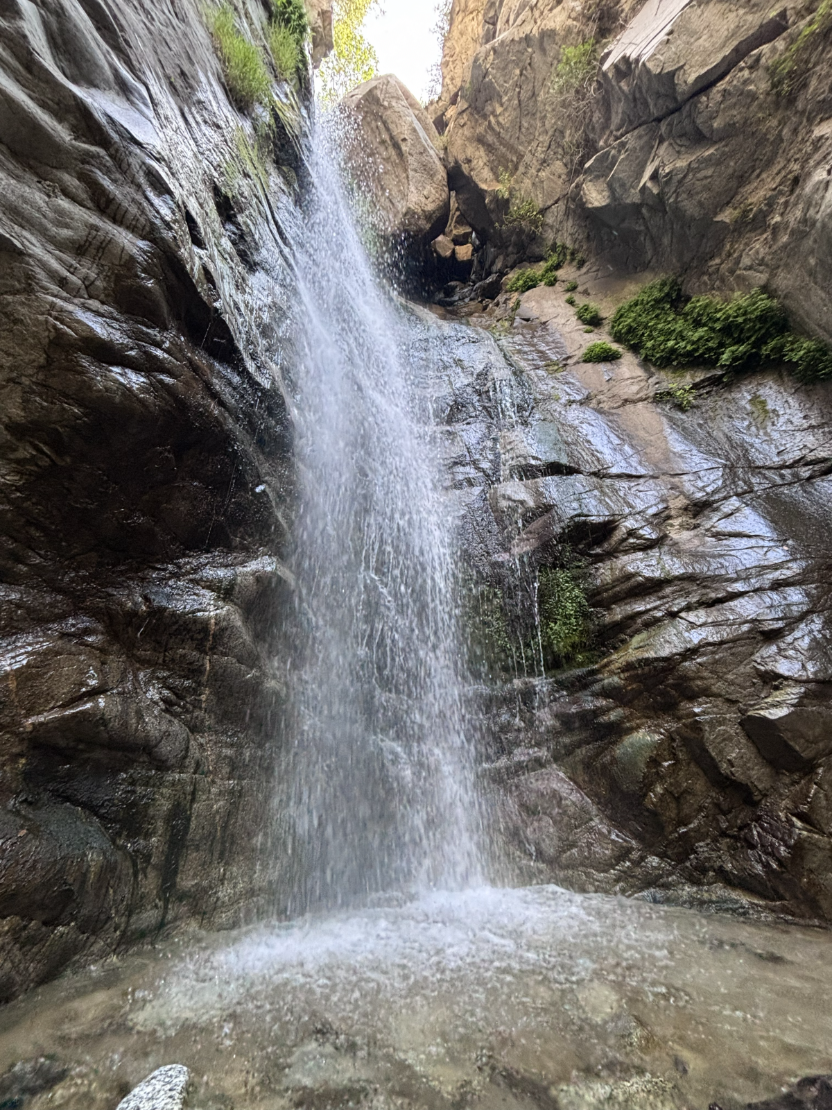
This 3.3- to 4.3-mile hike to Millard Canyon Falls will take you through lush hillsides and beneath the shade of coast live oaks and bigleaf maples as you walk alongside, and sometimes through, Millard Creek. Your journey ends at Millard Canyon Falls, a gorgeous 50(ish)-foot waterfall that gushes past massive boulders perched at the top of the cascade.
This hike is usually much shorter (about 1.5 miles), but a road closure in place since the Eaton fire lengthened it. I will explain more about the closure later. It is important to note, though, that Chaney Trail is the name of the roadway and an actual trail, both of which you’ll take on this hike.
To begin your hike, you can either parallel park near Nuccio’s Nurseries, taking care to obey all parking signage, or if those spots are all taken, park nearby and order a rideshare to drop you at the trailhead. I had cell reception with Verizon here, so it should be possible to order a ride back to your vehicle.

Millard Creek in Angeles National Forest.
(Jaclyn Cosgrove / Los Angeles Times)
From here, you have two options for reaching the Millard Canyon Falls trailhead.
1. Follow Chaney Trail road for about 1.66 miles to the Millard Canyon Falls trailhead. This route will be exposed, so you’ll need to start early if you choose this option.
2. Walk about half a third of a mile north from Nuccio’s, and then, near a bend in the road, you’ll take the Chaney Trail, a winding dirt path that I was delighted to find is in great shape. (Shout out to Restoration Legacy Crew, a volunteer trail maintenance group, for its amazing work in the Millard Canyon area!)
That trail is a bit overgrown in a few spots, so you’ll want to wear pants (or take the road). Additionally, make sure to lightly stomp before heading into overgrown areas, as this helps alert any snakes snoozing in the shade of your presence.

The view from the ground looking up at Millard Canyon Falls.
(Jaclyn Cosgrove / Los Angeles Times)
You’ll take Chaney Trail for about half a mile, pausing to catch your breath and take in the increasingly great views of the San Gabriel Valley. You will next cross over Mt. Lowe Motorway to take the Sunset Ridge Trail down. (See map for greater detail.)
You will boogie down a few switchbacks for 0.7 miles, enjoying shade provided by bay laurels and sumac trees, listening to the sweet songs of canyon wrens and spotted towhees. (That’s who was singing to me, anyway!)
You will reach the Millard Canyon campground, which is closed for overnight camping but does feature a few nice picnic tables shaded by massive coast live oaks. With the creek flowing nearby, I wouldn’t blame you if you stopped and had a little snack here.

Millard Campground in Angeles National Forest. It is closed because of damage from the Eaton fire.
(Jaclyn Cosgrove / Los Angeles Times)
That said, you have finally made it to the Millard Canyon Falls trailhead! Just northwest of the campground, you’ll find a little arrow pointing you northward onto the trail. From here, you will gain minimal elevation, and can actually just frolic. It is about half a mile to the waterfall.
As I mentioned, this trail is usually shorter and easier to access, as there’s a large parking lot near the trailhead and more parking along the roadway.
The roadway Chaney Trail was slated to reopen at the end of April. I frequently checked Los Angeles County Public Works’ road closure website, as I had planned to write about Millard Canyon once the road reopened. But when I checked the website, I saw that the reopening had been moved to the end of August. Huh?
I asked the public information officers at county Public Works about it and was told: “We are currently coordinating with our on-call emergency contractor to complete guardrail repairs on Chaney Trail, just north of the gate. Construction is anticipated to begin in July and be completed by the end of August, weather and field conditions permitting.”

Clockwise from top left: prickly phlox, golden yarrow, cliff aster and a type of larkspur. Center: A little bird on a dried out plant.
(Jaclyn Cosgrove / Los Angeles Times)
I passed a shiny new guardrail just north of the gate when I was hiking there earlier this week. I asked the agency whether there was some other guard rail missing. No, my friends. “The community raised concerns about the roadway narrowing included in this project, and we will be reconstructing the guardrail to address those concerns,” a spokesperson told me via email.
And now ends the saga of the Chaney Trail guardrail.
As for Millard Canyon, I will admit, it quite possibly is my favorite frontcountry natural areas. I was reminded of this fact when I visited this week. Although the road closure adds some steep mileage to reach the canyon, it’s worth it to me. I will be back. I hope to see you there!

The Fish Canyon Narrows near Castaic.
(Jaclyn Cosgrove / Los Angeles Times)
2. Fish Canyon to Fish Canyon Narrows
Distance: About 5.5 miles
Elevation gained: About 400 feet
Difficulty: Moderate
Dogs allowed? Yes
Accessible alternative: San Francisquito Creek Trail
To reach the Fish Canyon Narrows, you will take the Fish Canyon Trail (called Forest Route 6N32 or the Warm Springs Fish Canyon Truck Trail on some maps) on a 5.5(ish)-mile out-and-back journey. You will ascend into narrowing walls of sandstone, granite and conglomerate. A healthy stream flows throughout the canyon, giving you ample opportunity to cool off or have a picnic in a naturally occurring sound bath (which, when you’re lucky, will include a tree frog).
A quick note: This is the most rugged (read: least curated) of the three adventures mentioned in this list. There is no trail signage, and you’re in a less popular corner of Angeles National Forest. You might be entirely alone, especially if you hike this on a weekday. You should plan accordingly. Or skip it if I’ve already freaked you out. (I do this out of love!)
To begin, you’ll park on the road’s shoulder, and head east through a gate. Follow the roadway north and then south as it curves toward a dirt path. Follow the exposed dirt path northeast. You’ll trudge through multiple water crossings and be blessed with the occasional shade of sycamore trees.
The narrows are often cooler than the rest of the area. The first portion of this hike has little to no shade, so make sure to wear plenty of sun protection.
And if you leave the trail but aren’t ready to go home, head over to the swim beach at Castaic Lake. And if you’re not tired, there’s always the Cali Splash Park, a massive inflatable floating park. That’s a full day of adventure!

A hiker lies near the creek along the Icehouse Canyon Trail.
(Brian van der Brug / Los Angeles Times)
3. Icehouse Canyon Trail to Icehouse Saddle
Distance: Around 7 miles
Elevation gained: 2,600 feet
Difficulty: Challenging
Dogs allowed? Yes
Accessible alternative: West Fork National Scenic Bikeway
Icehouse Canyon Trail to Icehouse Saddle is a 7(ish)-mile trek that runs mostly parallel to the gorgeous and crystal clear Icehouse Creek, which often features several short waterfalls as the water rockets down the mountainside.
As they trek through the canyon shaded by bigleaf maple, California incense-cedar and bigcone Douglas-fir, hikers might spot wildflowers including orange-yellow western wallflowers, light purple Grinnell’s Beardtongue and red western columbine.
Icehouse Canyon is popular on weekends and is best visited on a weekday if you can swing it. You’ll need either a $5 Adventure Pass, an annual America the Beautiful pass or other federal public lands pass to park.
To begin your hike, you’ll park at or near the trailhead — in the parking lot if it’s your lucky day. Otherwise, you’ll park along the roadside, taking good care to read signage and not block anyone’s driveway. Once while walking to the trailhead, I was greeted by a local dog whose collar informed me that he was allowed to meander about and knew how to get back home. I love small mountain towns.
After you park — and remember to display your pass, as forest service workers do ticket vehicles without them — you’ll head east to the trailhead.

A visitor cools down in the creek at Icehouse Canyon.
(Jaclyn Cosgrove / Los Angeles Times)
Immediately upon entering the canyon, you’ll be greeted with stunning beauty. Try not to become too distracted by the pools of water surrounded by large boulders. (No one will know if you skip the hike and just take a dip.)
About a mile into your hike, you’ll come to a crossroad where the Chapman Trail and Icehouse Canyon Trail intersect. Continue east on the Icehouse Canyon Trail. A mile farther, you’ll start the switchback portion of the trail, where you’ll gain about 1,200 feet in 1.5 miles. It’s a beautiful suffer fest.
Icehouse Saddle will offer you incredible views of the San Gabriel Mountains and Mojave Desert. You’ll likely meet other hikers here who are planning to continue their journeys to one of several peaks reachable from the saddle, including to popular spots like Cucamonga and Ontario peaks.

Hikers meander past boulders and large pine trees.
(Brian van der Brug / Los Angeles Times)
It can be quite windy at Icehouse Saddle, so if you’re planning to have your lunch here (which I’ve done many times), consider packing a windbreaker.
The Times has been writing about hiking in Icehouse Canyon for more than 100 years, as city dwellers have long been drawn to its beauty. A July 1926 article about Icehouse Canyon started with a headline declaring, “Here’s a nice cool trip” in all caps.
“It is a trip which one will want to take more than once when its lure has gotten into the blood,” an unnamed Times journalist wrote.
May we all be so lucky to return again and again.

3 things to do

Docent Susan Hopkins leads a Pride Month hike during a previous year’s celebrations.
(L.A. County Department of Parks and Recreation)
1. Celebrate Pride across L.A. County
The L.A. County Department of Parks and Recreation will host several events celebrating LGBTQ+ Pride throughout June. Almost 60 county parks are hosting events, including from 5 to 7 p.m. Thursday at Dalton Park in Azusa; from 5 to 7 p.m. Thursday at Dr. Richard H. Rioux Park in Stevenson Ranch; and from noon to 2 p.m. Saturday at Crescenta Valley Community Regional Park in La Crescenta. For a list of all events, visit parks.lacounty.gov.
2. Walk for peace in L.A.
Los Angeles meditation nonprofit InsightLA will lead a free 12-mile Walk for Peace from 9 a.m. to 3 p.m. Saturday. The walk will start at Hollywood Forever Cemetery and end with community picnic at Tongva Park in Santa Monica. Register at insightla.org.
3. Repair trails in remote forest near L.A.
The Lowelifes Respectable Citizens’ Club, a volunteer trail maintenance group, needs volunteers on Saturday and Sunday to help restore an overgrown segment of the Gabrielino Trail in Angeles National Forest. Volunteers will either ride gravel bikes down a 5.5-mile dirt road or hike in. Previous trail work experience not required. Register by emailing trailwork@lowelifesrcc.org.

The must-read

The aedes aegypti mosquito, called the “yellow fever mosquito,” is well-known for spreading nasty illnesses like its namesake and dengue fever.
(Sameer Neamah Mahdi / Associated Press)
Here’s a sentence I didn’t expect to write this year (or ever): Google would like to release up to 64 million sterilized male mosquitoes in California and Florida to help combat mosquito-borne illnesses such dengue, Zika, chikungunya and yellow fever. “Google says it can harness technology to optimize a concept that’s been around for decades, but hasn’t worked at a large enough scale with mosquitoes to rein in disease,” Times staff writer Lila Seidman reported. The project is called Debug —although Google could have gone with WiFly.
I’ll see myself out.
Happy adventuring,

P.S.
You’re sitting there thinking about your weekend, wondering, “Is there anywhere I could go dressed as a shark?” Why, yes, there is! The Cabrillo Marine Aquarium and Cosplay for Science will co-host the Science Entertainment Aquarium Convention from 9 a.m. to 4 p.m. Saturday at the aquarium (3720 Stephen M. White Drive in San Pedro). SeaCon 2026 will feature a beach cleanup, a fictional marine biology panel and a cosplay contest, along with much more. Learn more at the aquarium’s Instagram page. Have a jaw-some time!
For more insider tips on Southern California’s beaches, trails and parks, check out past editions of The Wild. And to view this newsletter in your browser, click here.