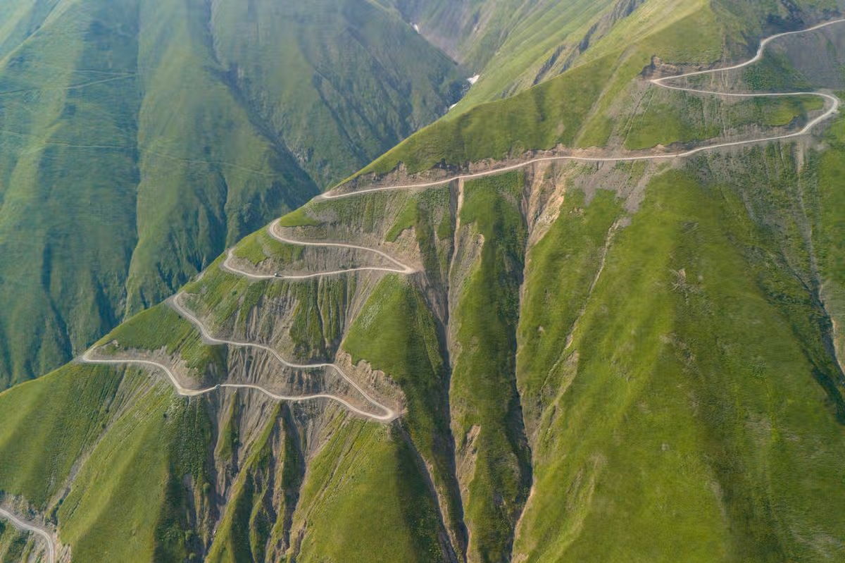
This road has some truly stunning views – but if you’re behind the wheel, it’s safer not to look at them.
This terrifying road is one of the most dangerous in Europe(Image: Getty)
Road trips can be a fabulous way to see the world – but hidden in a back corner of Europe is a road trip unlike any other. This mountain pass is infamous as one of the most dangerous in the world, travelling over the ranges with 70 foot drops, no guard rails and waterfalls crashing over your path.
Known as Europe’s ‘death road ’ the Abano Pass in the Caucasus Mountains of Georgia is widely known as the most dangerous road in Europe. It is the only vehicle route connecting the lowlands of the Kakheti region to the isolated mountain region of Tusheti.
It is approximately 70 kilometres long, but due to the extreme conditions it can take an experienced driver anything between four to six hours.
According to dangerousroads.org, between 10 and 12 people die in crashes every year on this isolated stretch of road.
It is a steep, winding road that is only open to 4×4 vehicles due to its rough and unpredictable surface, tight turns and precipitous climbs.
It is only open during the summer months from around May to October (depending on weather conditions).
Frequent rainfall and melting snow can trigger rockfalls or landslides which can wipe the road out entirely, and several waterfalls mean the road is often wet and slippery.
There are several waterfalls which crash across the road, and these can hide deep potholes beneath the water. If the water is heavier than usual, it also runs the risk of sweeping vehicles sideways off the road and down the sheer cliff face with little warning.
The road is also incredibly slim, making it terrifying if you meet another car coming the other way.
While some people may think there is room to pass by squeezing the two cars in close, this would be a mistake.
According to IsleofNomads, the road can quickly give way and send the car on the outside hurtling into the deep ravine below.
Instead, it is safer to very carefully reverse until you find a spot where you can tuck the car in off the road and allow the other vehicle to pass.
For those brave enough to traverse it, the Abano Pass does boast some truly jaw-dropping views – just make sure your driver is focused on the road, not the scenery.
AIRPORTS are a gateway to travel – but some of them are so much more than that with swimming pools, indoor rainforests and panoramic sky decks.
Travel + Leisure’s ‘World’s Best Awards’ named the top 10 airports – and sadly none are in the UK.
The impressive Singapore Changi Airport has the world’s biggest indoor waterfallCredit: AlamyIt has an airside hotel with a rooftop pool that’s open to allCredit: Unknown
The airports were declared the best by readers who voted in their thousands for their favourites in multiple categories for the publication.
At the very top of the ‘Best International Airports’ is Singapore Changi Airport which got a score of 95.19 out of 100.
Sign up for the Travel newsletter
Thank you!
Travel + Leisure said about Singapore Changi Airport: “Back on top after a two-year hiatus, this legendary hub has efficient operations, excellent hospitality, and eye-catching amenities like a butterfly garden and a swimmingpool.”
It stretches across five square miles and no one could ever say it’s an ordinary airport.
Inside is the world’s tallest indoor waterfall, a tropical rainforest, butterfly garden and even a hedge maze which is the largest in the country.
It also has a swimming pool and hot tub up on the roof at the airside Aerotel Singapore, which is even open to non-guests to watch the planes take off.
Hong Kong Airport has mountain views on Lantau IslandCredit: Hong Kong Airport
She said: “Within a few hours I’d strolled through a tropical rainforest, tucked into traditional sweets in a souq and had a sumptuous massage in a tranquil spa where airport stresses melt into distant memories.”
“The Orchard is the airport’s indoor tropical garden, constructed in 2022 – tall leafy palms and lush, green banana plants flourishing in the sunlight under a glass dome.
“All of the shrubs are real. The birds hiding within them are not, although the chirping sounds floating from hidden speakers nearly had me fooled.
“I wasn’t surprised to catch passengers reading a book on the artificial grass, or cosying down in one of the wooden tipis – with the noise of the nearby waterfall muffling out the chaos of a busy airport, this is surely the most peaceful spot in Hamad International.”
Sophie calls Hamad International Airport the ‘ultimate layover destination’Credit: AlamyZayed International Airport got a score of 91.24 out of 100Credit: Alamy
Coming in third spot is Istanbul Airport followed closely by Zayed International Airport in Abu Dhabi.
Dubai International Airport also made it onto the list even though, surprisingly, the hub will eventually close in around 10 years time.
The airport which has a wellness spa, luxury boutiques and sleepover lounges will close to make way for Al Maktoum International Airport.
Hong Kong International Airport on the list has incredible surroundings from mountains on Lantau Island to the South China Sea.
Visitors can take it in on the Sky Bridge which is the world’s longest airside pedestrian bridge – and there’s a Sky Deck with 360-degree views.
Other winners include Tokyo Haneda Airport and Adelaide Airport in Australia.
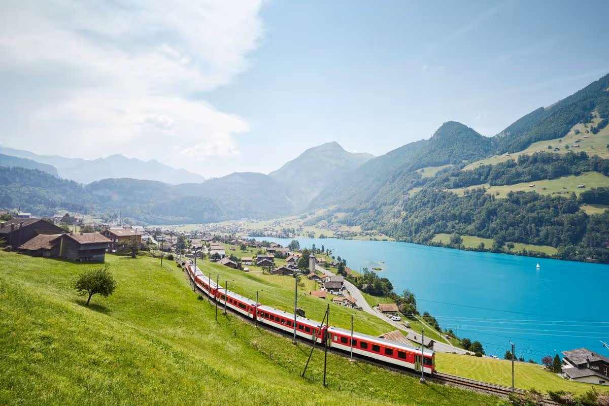
A woman has shared her experience on board a popular train route through Switzerland, which offers stunning views of Alpine lakes, waterfalls and mountain villages – and it’s only £30
The train journey offers stunning views (stock image)(Image: JJ Landscapes via Getty Images)
A train journey boasting spectacular views of sweeping lakes, mountain villages and much more has been turning heads – and it’ll only set you back £30. Visiting new destinations ranks among life’s most fulfilling and thrilling experiences, opening up fresh cultures, cuisines, ways of living, and a wealth of things to see and activities to do.
For those eager to book a trip away but anxious about the financial burden, a scenic rail journey could be just the ticket. Switzerland sits near the top of many people’s travel bucket lists, owing to its breathtaking alpine landscapes, world-class public transport network, and its legendary reputation for chocolate and cheese.
There’s something for everyone, whether you’re after an action-packed outdoor adventure such as skiing or hiking, or something more laid-back like soaking in mineral-rich thermal baths, leisurely cruises across glacial lakes, or exploring car-free alpine villages such as Mürren or Wengen.
One woman has been full of praise for the iconic Luzern-Interlaken Express, which is billed as “an unforgettable journey right into the heart of Switzerland”.
The nearly two-hour trip carries passengers “along the shores” of at least five “crystal-clear lakes”, “past romantic waterfalls and over the magnificent Brünig mountain pass”.
Sweeping panoramic windows ensure travellers can fully soak up the stunning scenery throughout the journey.
Travel enthusiast Dani Dimitrova captured her onboard experience on camera and posted the footage to TikTok. Over the clip, she included text referencing Switzerland’s notoriously pricey reputation: “‘Switzerland is so expensive’. This panoramic train is only £30.”
Content cannot be displayed without consent
In the caption, she went into further detail: “Everyone says Switzerland is expensive… and then I found the panoramic train from Interlaken to Lucerne for around £30.
“The Lucerne-Interlaken Express is one of the most scenic train journeys in Switzerland, taking just under 2 hours and passing lakes, waterfalls, mountain villages and some of the most incredible Alpine views along the way.”
Dani also shared some handy tips for those thinking about making the journey. She said: “Sit on the right-hand side when travelling from Interlaken to Lucerne for some of the best lake and mountain views.”
She also encouraged travellers planning to visit during the busy summer season to “book in advance”. Dani also noted that for those holding a Swiss Travel Pass, the journey is covered but “seat reservations are optional and cost extra”.
Lastly, she suggested keeping cameras at the ready for “the entire trip” as “the views change every few minutes”.
Dani added: “Honestly, if you’re visiting Switzerland and only have time for one train journey, make it this one.”
In the comments section, other TikTok users asked how to book, with one person describing the train route as “magical”.
Train tickets can be booked directly through the Luzern-Interlaken Express website. If you’re eager to secure the best views, seat reservations can be made as early as six months before your departure date.
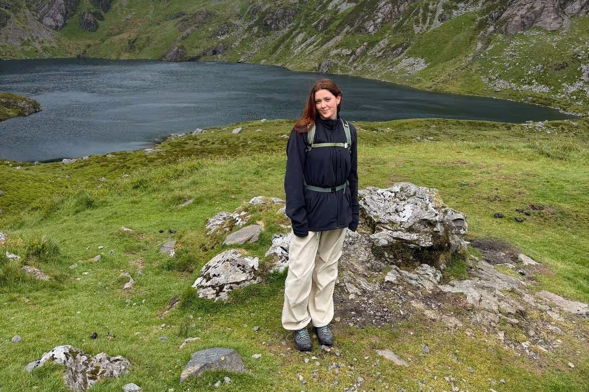
The national park’s a hotspot for tourism, but this particular walk felt like, at points, I could have been hiking in a tropical destination, with its bright green rugged cliffs
You don’t need to leave the UK to experience unreal views(Image: Emily Malia)
The more I travel around the UK, the more I am in awe of its natural beauty which seems to be overlooked by a lot of keen travellers, and this particular spot feels like a real slice of paradise.
You don’t need to hop on a plane to experience a sense of the tropics; it turns out you can immerse yourself in the brightest hues of green and walk along waterfalls in the north of Wales. While, of course, Snowdonia National Park is no secret, especially to avid hikers, cyclists and explorers, it was my first time visiting, and this specific route is one that blew me away.
It’s often cited as one of the best hikes in Snowdonia (Eryri). Cadair Idris is an 893-metre mountain in the southern part of the park and is renowned for its wild and rugged scenery. To me, it looked like its surroundings could belong in the likes of Peru or Southeast Asia, with its tropical plants, waterfalls and vibrancy of its green grass.
But of course, like any beautiful place in Wales, it reminded me exactly where I was when I spotted sheep dotted around its cliffs, even on the steepest parts. It looked as though the sheep could fall off the edge of the world, taking me with them, as I fought for hours against the growing pain in my shins, with each step up and up to the peak.
The route
I was taken up the Minffordd Path route, which is described as the shortest yet steepest route to the mountain’s summit, tackling a demanding 10 km walk. Overall it’s set to take up to four to five hours to complete, and in turn you are rewarded with dramatic and captivating views of the national park’s landscape.
The route begins at Dôl Idris car park and takes you past the Cadair Idris visitor centre, which quickly fills up. We were recommended to get there early in the morning to beat the pile-up and were thankful that we did; setting off on our walk at around 8am meant we got to experience the quietness of the route in all of its natural wonder. Albeit, the lie-in would have also been appreciated.
Running parallel along the stream which runs parallel to the stream which leads to Llyn Cau, the lake at the heart of the base of the mountain. It was immediately, when taking on these steep steps along the river, that I felt like I could be abroad.
Not only was the sun shining down on us, but the water was trickling down, with tropical plants growing around us, and it felt as wild and wonderful as the experiences I had in Thailand or the pictures I’ve seen of hikes in Vietnam or Peru.
This continued as we made our way out of the forest area and into the open air, with nothing but pure greenery around us, and the mountain stood proudly ahead. The second phase levels lightly as you enter a rocky amphitheatre, with up-close and personal views of the lake.
Pushing past slate and rocks, many of which are loose and therefore can be difficult to navigate, this section and throughout the walk, requires concentration and care with each step. A quick trip or fall could have you stumbling, and that’s why lots of hikers opt to go armed with sticks to help gain their balance and push them through.
By the time I made it to the top of the mountain, the weather dramatically changed, from sunny to high winds which were extremely cold. It’s this that can catch a lot of amateur hikers out, and I think it’s always best to go armed with windproof and waterproof layers, as they say ‘don’t dress for the car park’.
The real treat after that consistently steep hike upwards is this – the flat walk along the edge of the entire mountain before reaching its penultimate peak. Seeing it all from a circular angle gave you a real treat at each point whenever I decided to stop and take a breath.
Wales is the gift that keeps on giving when it comes to my explorations, and Cadair Idris was no exception to that. If you’re willing to take on the circular route and the real challenge of its steep and unsteady ground, then you will be rewarded with a touch of paradise and views you’ll continue to daydream about.
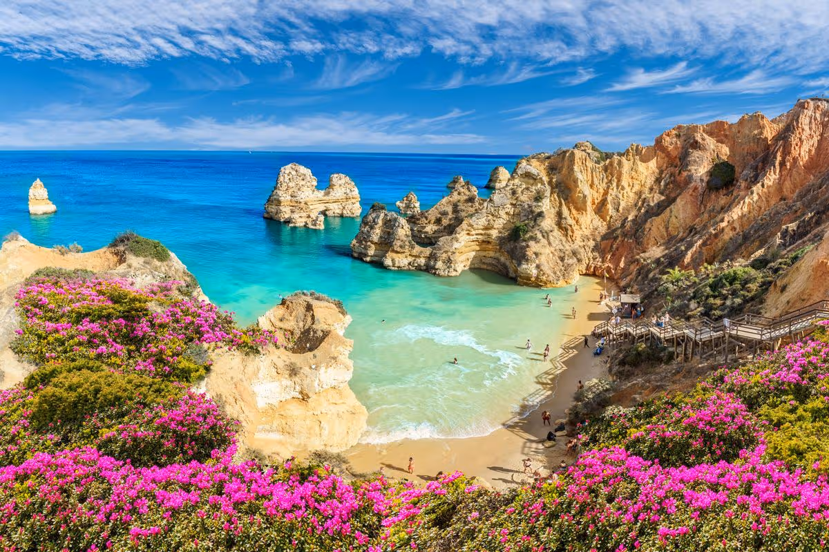
A holidaymaker has shared her experience of visiting what she calls the real ‘paradise’ of Portugal many tourists ignore, where she discovered a hidden waterfall and gorgeous beaches
People were amazed to learn about the ‘hidden gem’ of Portugal (stock image)(Image: Getty Images)
Despite the UK being forecast for another warm and sunny summer, the allure of jetting off abroad to unwind on a sun-drenched beach in a foreign country can prove hard to resist.
Just a two-hour flight from the UK, Portugal has long been a firm favourite among British holidaymakers, particularly given its reliably sunny and warm climate for much of the year. While cities such as Porto and the capital Lisbon remain among the most popular spots for tourists, one traveller now claims to have uncovered the ‘paradise of Portugal’ that many visitors don’t even know exists.
Taking to TikTok, a user going by the name ‘Solo Traveling Joy’ shared her experience of visiting the destination, revealing she had discovered a ‘hidden waterfall’ complete with a natural swimming pool, nestled among breathtaking scenery.
“Portugal is so underrated. And most people stick to Lisbon or Porto, but completely miss out on the Algarve,” she wrote in the caption of her post.
Content cannot be displayed without consent
The Algarve is Portugal’s spectacular southernmost region, stretching for over 200 kilometres along the coast. Whether you’re a nature enthusiast, a beach lover, or simply seeking somewhere to kick back and recharge, the Algarve is unlikely to leave you disappointed.
Celebrated for its year-round sunshine, striking ochre cliffs and sweeping golden beaches, it stands as a premier European hotspot for beach breaks, world-class golf and freshly caught seafood, according to Visit Portugal.
If you’re considering a stay in the Algarve, there’s no shortage of choices. The most sought-after destinations, however, are Lagos in the west and Tavira in the east, both widely regarded as the region’s finest spots. Lagos boasts striking golden cliffs and a lively town atmosphere, whereas Tavira delivers historic, untouched Portuguese character.
The secluded waterfall she featured in the clip is Queda do Vigario, situated near the rural village of Alte, which lies just off the A2 motorway linking Lisbon and the Algarve.
“This was one of my favourite natural swimming pools… peaceful, hidden, and 100% worth the detour,” the woman wrote in the caption accompanying her post.
“Go in the morning when no one is there!” she advised.
Viewers were swiftly captivated by the woman’s footage, with many rushing to the comment section to share their reactions.
“This looks like a hidden gem,” one person wrote, while another user said: “Wow, thanks for the tip.”
Another person said: “Adding this to my Portugal list! Amazing shots.” Someone else shared: “Been here today was lush.”
I was alone in the forest in my favorite place for the first time in years, so I did the only logical next right thing. I lay down.
There I was, sprawled next to Millard Canyon Falls, listening as the water roaring down the cliff and cool air whooshed past my face. I gained a new perspective when I gazed at an upside-down waterfall. What’s the point of hiking if we don’t play around?
In today’s edition of The Wild, our weekly outdoors newsletter, I provide you with three great hikes where rivers and waterfalls are still flowing. It’s essential information as we head into summer and temperatures start to rise.
You are reading The Wild newsletter
Sign up to get expert tips on the best of Southern California’s beaches, trails, parks, deserts, forests and mountains in your inbox every Thursday
By continuing, you agree to our Terms of Service, which include arbitration and a class action waiver. You agree that we and our third-party vendors may collect and use your information, including through cookies, pixels and similar technologies, for the purposes set forth in our Privacy Policy such as personalizing your experience and ads.
If you were to force me to choose my favorite hike, I would stubbornly refuse to pick just one, but my list would include these three.
That’s why I really want to urge you, my dear Wild reader, to treat these places with the reverence they deserve. That includes:
Refreshing your memory on the seven “Leave No Trace” principles.
Packing a small trash bag in which you can store empty food wrappers, toilet paper and garbage you spot along the way.
Observing wildlife from a distance, including California newts, which you shouldn’t pick up because it’s rude and, more important, because they can secrete a neurotoxin through their skin that can be lethal to humans.
OK, let’s talk about where your next favorite hike will be!
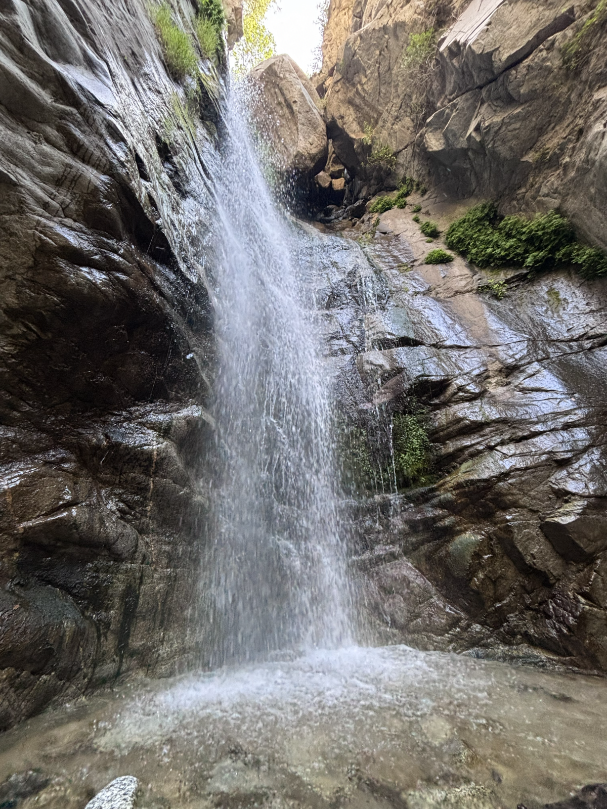
Millard Canyon Falls in Angeles National Forest.
(Jaclyn Cosgrove / Los Angeles Times)
1. Millard Canyon Falls
Distance: 3.3 to 4.3 miles (see below) Elevation gained: About 900 to 1,100 feet Difficulty: Moderate Dogs allowed? Yes Accessible alternative: Paved segment of Gabrielino Trail from Windsor Boulevard
This 3.3- to 4.3-mile hike to Millard Canyon Falls will take you through lush hillsides and beneath the shade of coast live oaks and bigleaf maples as you walk alongside, and sometimes through, Millard Creek. Your journey ends at Millard Canyon Falls, a gorgeous 50(ish)-foot waterfall that gushes past massive boulders perched at the top of the cascade.
This hike is usually much shorter (about 1.5 miles), but a road closure in place since the Eaton fire lengthened it. I will explain more about the closure later. It is important to note, though, that Chaney Trail is the name of the roadway and an actual trail, both of which you’ll take on this hike.
To begin your hike, you can either parallel park nearNuccio’s Nurseries, taking care to obey all parking signage, or if those spots are all taken, park nearby and order a rideshare to drop you at the trailhead. I had cell reception with Verizon here, so it should be possible to order a ride back to your vehicle.
Millard Creek in Angeles National Forest.
(Jaclyn Cosgrove / Los Angeles Times)
From here, you have two options for reaching the Millard Canyon Falls trailhead.
1. Follow Chaney Trail road for about 1.66 miles to the Millard Canyon Falls trailhead. This route will be exposed, so you’ll need to start early if you choose this option.
2. Walk about half a third of a mile north from Nuccio’s, and then, near a bend in the road, you’ll take the Chaney Trail, a winding dirt path that I was delighted to find is in great shape. (Shout out to Restoration Legacy Crew, a volunteer trail maintenance group, for its amazing work in the Millard Canyon area!)
That trail is a bit overgrown in a few spots, so you’ll want to wear pants (or take the road). Additionally, make sure to lightly stomp before heading into overgrown areas, as this helps alert any snakes snoozing in the shade of your presence.
The view from the ground looking up at Millard Canyon Falls.
(Jaclyn Cosgrove / Los Angeles Times)
You’ll take Chaney Trail for about half a mile, pausing to catch your breath and take in the increasingly great views of the San Gabriel Valley. You will next cross over Mt. Lowe Motorway to take the Sunset Ridge Trail down. (See map for greater detail.)
You will boogie down a few switchbacks for 0.7 miles, enjoying shade provided by bay laurels and sumac trees, listening to the sweet songs of canyon wrens and spotted towhees. (That’s who was singing to me, anyway!)
You will reach the Millard Canyon campground, which is closed for overnight camping but does feature a few nice picnic tables shaded by massive coast live oaks. With the creek flowing nearby, I wouldn’t blame you if you stopped and had a little snack here.
Millard Campground in Angeles National Forest. It is closed because of damage from the Eaton fire.
(Jaclyn Cosgrove / Los Angeles Times)
That said, you have finally made it to the Millard Canyon Falls trailhead! Just northwest of the campground, you’ll find a little arrow pointing you northward onto the trail. From here, you will gain minimal elevation, and can actually just frolic. It is about half a mile to the waterfall.
As I mentioned, this trail is usually shorter and easier to access, as there’s a large parking lot near the trailhead and more parking along the roadway.
The roadway Chaney Trail was slated to reopen at the end of April. I frequently checked Los Angeles County Public Works’ road closure website, as I had planned to write about Millard Canyon once the road reopened. But when I checked the website, I saw that the reopening had been moved to the end of August. Huh?
I asked the public information officers at county Public Works about it and was told: “We are currently coordinating with our on-call emergency contractor to complete guardrail repairs on Chaney Trail, just north of the gate. Construction is anticipated to begin in July and be completed by the end of August, weather and field conditions permitting.”
Clockwise from top left: prickly phlox, golden yarrow, cliff aster and a type of larkspur. Center: A little bird on a dried out plant.
(Jaclyn Cosgrove / Los Angeles Times)
I passed a shiny new guardrail just north of the gate when I was hiking there earlier this week. I asked the agency whether there was some other guard rail missing. No, my friends. “The community raised concerns about the roadway narrowing included in this project, and we will be reconstructing the guardrail to address those concerns,” a spokesperson told me via email.
And now ends the saga of the Chaney Trail guardrail.
As for Millard Canyon, I will admit, it quite possibly is my favorite frontcountry natural areas. I was reminded of this fact when I visited this week. Although the road closure adds some steep mileage to reach the canyon, it’s worth it to me. I will be back. I hope to see you there!
The Fish Canyon Narrows near Castaic.
(Jaclyn Cosgrove / Los Angeles Times)
2. Fish Canyon to Fish Canyon Narrows
Distance: About 5.5 miles Elevation gained: About 400 feet Difficulty: Moderate Dogs allowed? Yes Accessible alternative:San Francisquito Creek Trail
To reach the Fish Canyon Narrows, you will take the Fish Canyon Trail (called Forest Route 6N32 or the Warm Springs Fish Canyon Truck Trail on some maps) on a 5.5(ish)-mile out-and-back journey. You will ascend into narrowing walls of sandstone, granite and conglomerate. A healthy stream flows throughout the canyon, giving you ample opportunity to cool off or have a picnic in a naturally occurring sound bath (which, when you’re lucky, will include a tree frog).
A quick note: This is the most rugged (read: least curated) of the three adventures mentioned in this list. There is no trail signage, and you’re in a less popular corner of Angeles National Forest. You might be entirely alone, especially if you hike this on a weekday. You should plan accordingly. Or skip it if I’ve already freaked you out. (I do this out of love!)
To begin, you’ll park on the road’s shoulder, and head east through a gate. Follow the roadway north and then south as it curves toward a dirt path. Follow the exposed dirt path northeast. You’ll trudge through multiple water crossings and be blessed with the occasional shade of sycamore trees.
The narrows are often cooler than the rest of the area. The first portion of this hike has little to no shade, so make sure to wear plenty of sun protection.
And if you leave the trail but aren’t ready to go home, head over to the swim beach at Castaic Lake. And if you’re not tired, there’s always the Cali Splash Park, a massive inflatable floating park. That’s a full day of adventure!
A hiker lies near the creek along the Icehouse Canyon Trail.
(Brian van der Brug / Los Angeles Times)
3. Icehouse Canyon Trail to Icehouse Saddle
Distance: Around 7 miles Elevation gained: 2,600 feet Difficulty: Challenging Dogs allowed? Yes Accessible alternative:West Fork National Scenic Bikeway
Icehouse Canyon Trail to Icehouse Saddle is a 7(ish)-mile trek that runs mostly parallel to the gorgeous and crystal clear Icehouse Creek, which often features several short waterfalls as the water rockets down the mountainside.
As they trek through the canyon shaded by bigleaf maple, California incense-cedar and bigcone Douglas-fir, hikers might spot wildflowers including orange-yellow western wallflowers, light purple Grinnell’s Beardtongue and red western columbine.
Icehouse Canyon is popular on weekends and is best visited on a weekday if you can swing it. You’ll need either a $5 Adventure Pass, an annual America the Beautiful pass or other federal public lands pass to park.
To begin your hike, you’ll park at or near the trailhead — in the parking lot if it’s your lucky day. Otherwise, you’ll park along the roadside, taking good care to read signage and not block anyone’s driveway. Once while walking to the trailhead, I was greeted by a local dog whose collar informed me that he was allowed to meander about and knew how to get back home. I love small mountain towns.
After you park — and remember to display your pass, as forest service workers do ticket vehicles without them — you’ll head east to the trailhead.
A visitor cools down in the creek at Icehouse Canyon.
(Jaclyn Cosgrove / Los Angeles Times)
Immediately upon entering the canyon, you’ll be greeted with stunning beauty. Try not to become too distracted by the pools of water surrounded by large boulders. (No one will know if you skip the hike and just take a dip.)
About a mile into your hike, you’ll come to a crossroad where the Chapman Trail and Icehouse Canyon Trail intersect. Continue east on the Icehouse Canyon Trail. A mile farther, you’ll start the switchback portion of the trail, where you’ll gain about 1,200 feet in 1.5 miles. It’s a beautiful suffer fest.
Icehouse Saddle will offer you incredible views of the San Gabriel Mountains and Mojave Desert. You’ll likely meet other hikers here who are planning to continue their journeys to one of several peaks reachable from the saddle, including to popular spots like Cucamonga and Ontario peaks.
Hikers meander past boulders and large pine trees.
(Brian van der Brug / Los Angeles Times)
It can be quite windy at Icehouse Saddle, so if you’re planning to have your lunch here (which I’ve done many times), consider packing a windbreaker.
The Times has been writing about hiking in Icehouse Canyon for more than 100 years, as city dwellers have long been drawn to its beauty. A July 1926 article about Icehouse Canyon started with a headline declaring, “Here’s a nice cool trip” in all caps.
“It is a trip which one will want to take more than once when its lure has gotten into the blood,” an unnamed Times journalist wrote.
May we all be so lucky to return again and again.
3 things to do
Docent Susan Hopkins leads a Pride Month hike during a previous year’s celebrations.
(L.A. County Department of Parks and Recreation)
1. Celebrate Pride across L.A. County The L.A. County Department of Parks and Recreation will host several events celebrating LGBTQ+ Pride throughout June. Almost 60 county parks are hosting events, including from 5 to 7 p.m. Thursday at Dalton Park in Azusa; from 5 to 7 p.m. Thursday at Dr. Richard H. Rioux Park in Stevenson Ranch; and from noon to 2 p.m. Saturday at Crescenta Valley Community Regional Park in La Crescenta. For a list of all events, visit parks.lacounty.gov.
2. Walk for peace in L.A. Los Angeles meditation nonprofit InsightLA will lead a free 12-mile Walk for Peace from 9 a.m. to 3 p.m. Saturday. The walk will start at Hollywood Forever Cemetery and end with community picnic at Tongva Park in Santa Monica. Register at insightla.org.
3. Repair trails in remote forest near L.A. The Lowelifes Respectable Citizens’ Club, a volunteer trail maintenance group, needs volunteers on Saturday and Sunday to help restore an overgrown segment of the Gabrielino Trail in Angeles National Forest. Volunteers will either ride gravel bikes down a 5.5-mile dirt road or hike in. Previous trail work experience not required. Register by emailing trailwork@lowelifesrcc.org.
The must-read
The aedes aegypti mosquito, called the “yellow fever mosquito,” is well-known for spreading nasty illnesses like its namesake and dengue fever.
(Sameer Neamah Mahdi / Associated Press)
Here’s a sentence I didn’t expect to write this year (or ever): Google would like to release up to 64 million sterilized male mosquitoes in California and Florida to help combat mosquito-borne illnesses such dengue, Zika, chikungunya and yellow fever. “Google says it can harness technology to optimize a concept that’s been around for decades, but hasn’t worked at a large enough scale with mosquitoes to rein in disease,” Times staff writer Lila Seidman reported. The project is called Debug —although Google could have gone with WiFly.
I’ll see myself out.
Happy adventuring,
P.S.
You’re sitting there thinking about your weekend, wondering, “Is there anywhere I could go dressed as a shark?” Why, yes, there is! The Cabrillo Marine Aquarium and Cosplay for Science will co-host the Science Entertainment Aquarium Convention from 9 a.m. to 4 p.m. Saturday at the aquarium (3720 Stephen M. White Drive in San Pedro). SeaCon 2026 will feature a beach cleanup, a fictional marine biology panel and a cosplay contest, along with much more. Learn more at the aquarium’s Instagram page. Have a jaw-some time!
For more insider tips on Southern California’s beaches, trails and parks, check out past editions of The Wild. And to view this newsletter in your browser, click here.