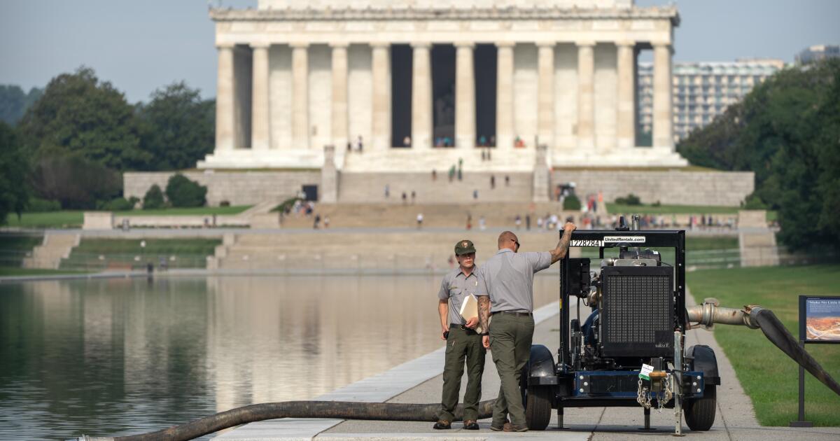
WASHINGTON — Crews are again draining the Lincoln Memorial Reflecting Pool as President Trump’s problem-plagued efforts to revamp the waterway pushes well past his initial goal of having it ready by July 4 to mark the nation’s 250th birthday.
The president at first suggested his renovations would last a century. But within weeks of the project originally reaching completion last month, the water was beset by an algae bloom and pieces of the new coating appeared to be peeling off the bottom.
Trump has blamed the peeling on vandals, though critics allege it’s from shoddy repair work.
Interior Secretary Doug Burgum, whose agency oversees the National Park Service, told conservative podcaster Katie Miller in an interview released earlier this week that the new round of draining was planned. He also said that the water might still contain debris from an extensive Independence Day fireworks display over the National Mall.
“Drain the water, clean up the fireworks stuff,” Burgum told Miller, who is the wife of deputy White House chief of staff Stephen Miller. “Repair the vandalism that was done. Fill it back up again.”
The work on the Reflecting Pool is just one of a number of projects Trump has spearheaded across the nation’s capital. Most prominently, he demolished the White House’s East Wing to build a $400-million ballroom and plans to build a towering arch between the Lincoln Memorial and Arlington National Cemetery.
He initially announced his intentions to beautify the Reflecting Pool this spring, saying he wanted it completed before the nation’s 250th birthday celebrations.
Water was drained and Trump directed that the bottom be painted what he called “American flag blue.” In May, the president posted on his social media site of the pool: “The goal is to have it done, at this higher level, prior to July 4th — We are ahead of schedule!”
But problems began quickly after the initial work was finished. Trump blamed vandals, and court documents later showed that the National Park Service reported to the U.S. Park Police a June 9 incident in which a sharp knife or razor cut the pool’s new liner.
On Thursday, former Olympic canoe racer David Hearn pleaded not guilty in D.C. Superior Court to deliberately damaging the Reflecting Pool. Hearn has said he reached inside the pool to examine the peeled sealant and let go of a chunk when he was told to by a park worker.
His attorneys and other Trump administration critics have derided the case as an abuse of prosecutorial power and maintain he is being scapegoated for the poor job done fixing up the Reflecting Pool.
At least three other people have been charged in the same court with misdemeanors for allegedly removing pieces of paint from the Reflecting Pool, according to online court records. All three pleaded not guilty during their initial court appearances Wednesday.
The pool was closed for the Independence Day celebration, which featured what Trump said was the largest fireworks display in the world. The president had said that the pool would have to be drained anew as part of the new round of repairs.
Burgum has also said that the Trump administration won’t seek bids for the new rounds of repairs. He told CNN’s “State of the Union” last weekend: “We’ll use the same company because they did a fantastic job.”
Ohio-based Green Water Solutions, also known as Greenwater Services, was given a $1.7-million contract to install a water-purification system in the Reflecting Pool, while Virginia-based Atlantic Industrial Coatings was awarded $14.7 million to repaint and waterproof the pool’s concrete floor.
Democratic senators and House members are investigating the pool project, including seeking answers about how much taxpayer funding is involved.
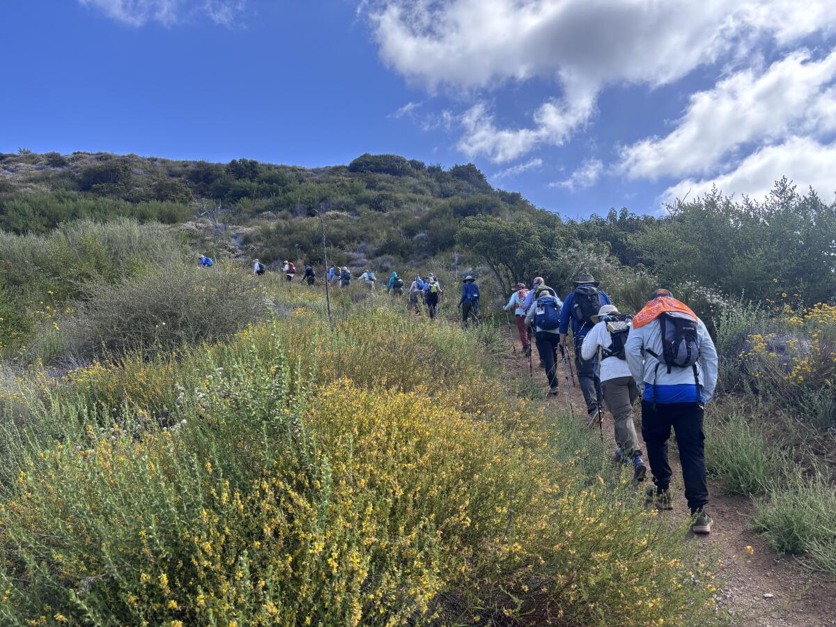
It’s a Tuesday evening, just before sunset, and I am in a meadow thrashing an air guitar with a dozen strangers in Griffith Park.
We take the lyrics to Prince’s “Let’s Go Crazy” literally as we gyrate and bend to the song’s iconic guitar solo, which lasts almost 45 seconds. Huffing and puffing, we leave the meadow, laughing together at the beautiful end of the hourlong “silent disco” hike we completed along one of the park’s dirt trails.
I stay for an extra 45 minutes, talking to two other dancers whom I hope become future friends — and that we all dance together again soon.
You are reading The Wild newsletter
Sign up to get expert tips on the best of Southern California’s beaches, trails, parks, deserts, forests and mountains in your inbox every Thursday
By continuing, you agree to our Terms of Service, which include arbitration and a class action waiver. You agree that we and our third-party vendors may collect and use your information, including through cookies, pixels and similar technologies, for the purposes set forth in our Privacy Policy such as personalizing your experience and ads.
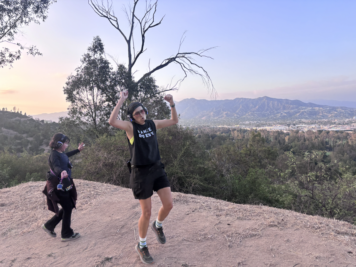
That night, I participated in Dance Quest’s silent disco hike, a new way to experience Griffith Park where participants shimmy and shake on a trail alongside L.A. improviser and comedian Kristen Smith.
For a suggested donation of up to $25 — Smith emphasizes that no one will be turned away for lack of funds — participants don headphones and hike as they listen to a playlist that Smith has curated. That Tuesday night’s playlist included Donna Summer, Madonna and Carly Rae Jepsen (whom Smith unapologetically stans).
Smith plans to host at least two night hikes a month, but will schedule more if those events sell out. She’s taking a brief pause, though, because her wife gave birth to their second child last Thursday.
Dance Quest leader Kristen Smith pumps her fists in the air on an overlook along a trail in Griffith Park.
(Jaclyn Cosgrove / Los Angeles Times)
I’m kind of an experiential purist when it comes to hiking — never headphones, never music. I love putting my phone away and just being there with the trees and bees. I couldn’t help but wonder: Would this silent disco ruin or enhance the outdoors experience?
I was pleasantly surprised by the answer, but I think it largely depends on who leads the dancing.
Smith, a tribal member of the Chickasaw Nation who identifies as two spirit and uses she/they pronouns, said they were inspired to start Dance Quest while on a trip to Scotland in 2024 to celebrate their mother’s 70th birthday.
Kristen Smith of Dance Quest leads hikers on a silent disco trek through Griffith Park.
(Jaclyn Cosgrove / Los Angeles Times)
While out and about, Smith and her mom spotted Guru Dudu, a character created by Melbourne-based performer David Naylor, leading a silent disco through the streets of Edinburgh.
“That looks fun,” Smith’s mom said.
They both signed up for a tour, led by Dudu, who wore a purple sequin jumpsuit.
“We danced through the very crowded streets of Edinburgh, and it was the most fun I’d had in such a long time,” Smith said.
L.A. artist Heidi Neilson, center, dances alongside other silent disco hikers in Griffith Park.
(Jaclyn Cosgrove / Los Angeles Times)
Smith, who’d spent years performing on stages throughout L.A., had been stuck inside and away from people for much of the COVID-19 pandemic.
In summer 2021, just as vaccines were becoming available and it was becoming safer to gather with groups indoors, Smith was diagnosed with follicular lymphoma, a type of non-Hodgkin lymphoma.
Smith’s summer was soon full of surgeries and tests until they started chemotherapy that September, receiving a dose every three weeks until early 2022, when their doctors switched Smith to chemotherapy every three months.
Smith’s treatment was going well, but that didn’t mean an immediate return to normalcy was on the horizon. Her doctors said Smith and her family needed to assume Smith’s COVID-19 vaccine didn’t give her immunity to the virus.
As Smith watched her friends return to a semblance of their pre-pandemic lives, she worked inside at her Nickelodeon job, grateful for health insurance and employment in the entertainment industry, but missed the joy and connection that comes with performing.
Kristen Smith of Dance Quest is surrounded by silent disco dancers in Griffith Park.
(Jaclyn Cosgrove / Los Angeles Times)
Smith kept wondering how they could find a way to remain active and connect with others. Plus, being outside remains the safest option for Smith to be around people, as the type of cancer they have is not considered curable and is managed like a chronic illness.
“I know that one of the things that I offer to the world is joy and sparkly effervescence,” Smith said. “I was like, ‘What can I do to be my own boss, is something that’s of service to people in this time of darkness and is also good for me as well?’”
During the silent disco in Edinburgh, Smith realized as they danced alongside others that they felt like they were performing and letting go in a way they hadn’t been able to do in a long time. “When we finished, I was like, ‘I can do this,’” Smith said.
Smith told their mentor at Nickelodeon about their idea to start Dance Quest and they immediately encouraged them to give it a shot. Smith bought the equipment the next week and launched Dance Quest, her company that hosts the silent disco hikes, earlier this year. After doing a test run with friends and family, they started hosting events in the park.
When I arrived to the silent disco, I quickly met my fellow dancers, a welcoming group of people ages 5 and older. I liked that I could adjust the volume on my headphones rather than listen to music all at the same volume.
Holly Gray, an L.A. event planner, throws her arms in the air alongside other dancers in Griffith Park.
(Jaclyn Cosgrove / Los Angeles Times)
We took a wide dirt path in the park that’s not as popular as other routes, which allowed us to spread out and really do whatever we wanted. I quickly realized this was primarily going to be a lot of frolicking to a good beat, which was exactly what I wanted.
Along the way, Smith pointed out invasive plants like black mustard and native plants and animals that live in the park. Whenever a hiker headed our way, we made a tunnel of “spirit fingers” for them to pass through, which I detected 95% of people actually enjoyed. In today’s fast-paced and often negatively focused world, it’s kind of nice to turn a corner and find strangers cheering for you.
Smith, who taught improv to children, teenagers and business professionals, will not force participants to dance. That isn’t the purpose of Dance Quest.
Kristen Smith of Dance Quest, center, leads two children along a dirt path in Griffith Park.
(Jaclyn Cosgrove / Los Angeles Times)
Rather, it’s to find joy with others and escape the harsh political environment that queer and BIPOC people face on a daily basis.
“When you put on the headphones, you forget how you look, and hopefully I provide a no-pressure environment where, however your body tells you to move, you move that way,” Smith said. “And there’s strength in numbers with the silent disco.”
3 things to do
Families play volleyball at an L.A. County overnight camping event at a local park.
(Los Angeles County Department of Parks and Recreation)
1. Camp with family and friends around L.A. Los Angeles County Parks and Recreation will host family campouts on weekends in July and August at five of its parks. That includes campouts at Castaic Lake Recreation Area at 6 p.m. Friday; Frank G. Bonelli Regional Park in San Dimas at 6 p.m. Friday; Kenneth Hahn State Recreation Area at 6 p.m. July 17; and 6 p.m. July 24 at Santa Fe Dam Recreation Area. Those parks, along with Whittier Narrows Recreation Area, will host additional family campouts in August. General admission is $15. Children age 13 and younger are free. To register, visit anc.apm.activecommunities.com.
2. Clear out streambeds in L.A. Friends of Griffith Park needs volunteers from 8:30 to 11 a.m. Saturday in the park’s Fern Dell hiking area. Participants will clean streambeds and trails, yanking weeds and restoring habitat. Learn more at friendsofgriffithpark.org.
3. Kayak the L.A. River near Van Nuys L.A. River Expeditions will host a two-hour kayak tour at multiple times Saturday through the Sepulveda Basin, a lush area of the Los Angeles River. Paddlers will move through the tree-lined, mud-packed riverbanks, observing local fish and birds. Trips are at 9 a.m., 12:30 p.m. and 3:30 p.m. Tickets are $53.74. Register at eventbrite.com.
The must-read
Mary Saba Tehran takes part in a Mindful Archery class at the Woodley Park Archery Range in Van Nuys.
(Eric Thayer / Los Angeles Times)
Times staff writer Deborah Vankin recently learned via a bow and arrow the importance and freedom that can come with literally letting go. Vankin wrote about her experiencing at Mindful Archery, a course led by spiritual counselor and archer Angie Fadel at Woodley Park Archery Range in Van Nuys. Fadel said her goal is to help female and BIPOC participants release something holding them back or take aim at a goal. “An archery range can be a very white, male-dominated space,” she said. “And the stance, with a bow and arrow in your hand, shooting — it’s very male. And [men] don’t have any problem, most of the time, taking up space. So it is a practice to remind ourselves, as a queer woman, a trans person, nonbinary person, anybody that’s kind of othered in our society, to be able to take up space. To adopt a power stance and be, like, ‘I’m allowed to be here.’”
Happy adventuring,
P.S.
Great news! State lawmakers have selected the California State Library park pass to receive ongoing funding in future budget cycles. Previously, lawmakers had to approve funding every year for the program to be added into the state’s budget, according to the California State Parks Foundation. This development means Californians will be able to check out a state parks pass for free at their local library for the foreseeable future, unless a governor or the Legislature announces otherwise. In L.A. County, participating parks include the Antelope Valley California Poppy Reserve, Leo Carrillo State Park, L.A. State Historic Park and Malibu Creek State Park. You can find out which library near you offers the pass by visiting this interactive map. Have fun out there!
For more insider tips on Southern California’s beaches, trails and parks, check out past editions of The Wild. And to view this newsletter in your browser, click here.
Like many outdoors lovers, I love a last-minute camping trip.
There’s a special kind of magic when the stars align, you snag a reservation and realize you’ll soon be sleeping under the stars in a place you’ve never been.
But given the popularity of California’s campgrounds, is it really possible to book a campsite on short notice? In this edition of The Wild, our weekly outdoors newsletter, I will explain not only how you can but also where you will be more likely to find open spots (even, if lucky, on a holiday weekend).
You are reading The Wild newsletter
Sign up to get expert tips on the best of Southern California’s beaches, trails, parks, deserts, forests and mountains in your inbox every Thursday
By continuing, you agree to our Terms of Service, which include arbitration and a class action waiver. You agree that we and our third-party vendors may collect and use your information, including through cookies, pixels and similar technologies, for the purposes set forth in our Privacy Policy such as personalizing your experience and ads.
L.A. sits within a quick drive to both the San Gabriel and Santa Monica mountains, two expansive ranges that offer multipleopportunities.
But first, I want to share what I learned in my conversation with Mike Lee, owner of Campsite Tonight, a website and app that monitors campgrounds throughout California for cancellations so its users can book sites.
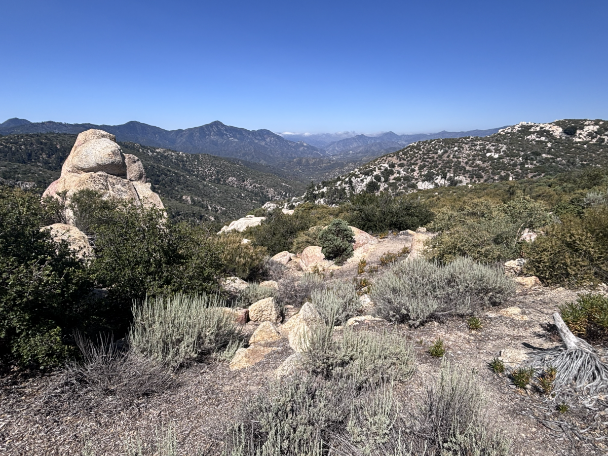
One of the expansive views of the San Gabriel Mountains that can be found at Chilao Campground.
(Jaclyn Cosgrove / Los Angeles Times)
I’ve long been a skeptic of using private websites to book a campsite on public lands. But given Lee is an avid camper, dad and Californian running the site on his own, I wanted to hear him out.
Lee was motivated to take over Campsite Tonight a few years ago after finding himself frequently frustrated with how challenging it was to book campsites at state and national parks in California at times when his busy family could take a vacation.
Campsite Tonight frequently scans several websites throughout California and several other states (including Utah for those dreaming of a trip to Zion National Park). His site checks the popular campgrounds every 12 seconds for cancellations while less popular campgrounds are scanned often but less frequently.
He also offers data for popular campsites too, so users can learn more about when to look. For example, at Yosemite’s Upper Pines Campground, Lee includes that 11 a.m. Pacific is the peak hour when cancellations appear (and about 31% of reservations there are booked within seven days of arrival).
A tent in the evening light at Upper Pines Campground in Yosemite National Park.
(William Hale Irwin / For The Times)
Lee’s app offers limited-but-still-useful features to free users, including some ability to search for open sites, and is $29.99 a month or $59.99 a year for advanced features, including the option to more rapidly book a campsite at a national park by essentially linking your Campsite account with your Recreation.gov account.
Running the website has “taught me, as I’ve looked at the data more and more, that last-minute camping is actually pretty achievable,” Lee said while sitting inside a tent in a campground near Yosemite. “The biggest thing is being flexible. Before, if I didn’t book it in advance or if I didn’t get [a site when I wanted], I would never look again. Now I look more.”
Lee said he’s noticed fewer cancellations on long weekends, although there will still be families that can’t make their trips. After we initially spoke, Lee built a page specifically to scan for campsites available over Fourth of July weekend. I was surprised by just how much remained open.
Leo Carrillo State Beach.
(Mike Cilantro / For The Times)
Scanning the page on Tuesday, I noticed a spot at Leo Carrillo State Park. Although it was for Wednesday night, I was tempted. Multiple campsites remained open in Los Padres National Forest, even over the weekend. A random campground in Sequoia National Forest made me look at just how far of a drive it would be from my apartment. And I noticed there was even a spot free at a Big Sur campground on Sunday evening. “No, you can’t, er, you shouldn’t drive that far for one night of camping,” I told myself. (Should I, though?)
That said, there are several first-come, first-served campgrounds near L.A., especially in Angeles National Forest, for those who’d like to stay closer to home or can’t find something online.
Here is a quick guide to what I recommend trying to snag. Given it’s a holiday weekend, it will still be more challenging, but if you can leave early Friday, I don’t think it’ll be impossible to camp at one of these spots.
For those looking for simple car camping (beginner)
A campsite at Chilao Campground with a large campfire ring.
(Jaclyn Cosgrove / Los Angeles Times)
Each of these campgrounds are in Angeles National Forest, offer piped water and vault toilets, and have sites with picnic tables, parking spots and campfire rings.
Chilao Campground: A large campground with 84 sites spread over two loops, Little Pines and Manzanita. Its landscape features large boulders, sweeping views and pine trees (especially the eponymous loop). Piped water is available, although it is at times turned off, so please check the campground website before heading out. The Chilao Visitor Center, open on the weekends, is nearby.
A campsite in Chilao Campground shaded by several pine trees.
(Jaclyn Cosgrove / Los Angeles Times)
Crystal Lake: A 120-site campground north of Azusa. It sits at 5,539-feet elevation and features great views of nearby peaks, including Mt. Islip and Windy Gap. Visitors can fish in Crystal Lake when it’s deep enough and find a hot meal at Crystal Lake Cafe and General Store.
Monte Cristo: A campground with 19 individual drive-in sites, including some with large shady sycamore trees. A small seasonal creek runs through the middle of the campground and has small pools in spring and early summer. (Note: Because of its proximity to L.A., this one can fill up quickly.)
For adventurers willing to plan just a bit, even last minute (intermediate)
Oak Flat Campground.
(Jaclyn Cosgrove / Los Angeles Times)
These sites offer their own escape, but because they lack potable water (unless otherwise noted) and are farther away from L.A., they require more planning than those on the “beginner” list. Each site has picnic tables and campfire rings. The campgrounds below are in Angeles National Forest unless otherwise noted.
Horse Flats: A shaded 26-site campground that offers easy access to nearby trails, including Mt. Hillyer and the Silver Moccasin Trail.
Oak Flat: A campground north of Castaic just off the 5 Freeway with 20 sites situated around a nice small meadow shaded by several oak trees.
Musch Trail Camp: This small-but-charming backpacking campground in Topanga State Park features flush toilets and sinks and requires only a one-mile hike in, a trek that’s on the easier end of moderate.
Sawmill: A rustic eight-site campground whose main challenge, outside of its lack of water, is just reaching it, as campers must take a steep gravel road off Pine Canyon Road (see website for information on road closure).
For experienced trekkers looking for quick escapes (expert)
One of a handful of sites at the Valley Forge Trail Camp in Angeles National Forest.
(Jaclyn Cosgrove / Los Angeles Times)
These backpacking sites offer backcountry adventures for those with the time and the right gear.
Glenn Camp: A 10-site forested haven next to the West Fork of the San Gabriel River that’s reached via a seven-mile paved road that can be hiked or biked; no restrooms available, so campers will need to follow Leave No Trace principles.
Valley Forge: Reachable via 2.4-mile hike along the Gabrielino Trail from Red Box Picnic Area, this six(ish)-site campground has picnic tables, campfire rings, vault toilets and is a sylvan refuge of mighty pines next to the pristine West Fork of the San Gabriel River.
Cooper Canyon: A backcountry campground shaded by towering old pine trees with about five sites, offering vault toilets, campfire rings, klamath stoves, large picnic tables and bear-proof boxes. Because of the Angeles Crest Highway closure, you will need to reach the site either by walking the closed road or Pacific Crest Trail.
Regardless of where and when you go, I hope you have a wonderful time enjoying our public lands. Please remember to practice the Leave No Trace principles and, in short, leave it cleaner than you found it!
3 things to do
A volunteer waters plants in the nursery at North East Trees in Ascot Hills Park in El Sereno.
(William Hallstrom)
1. Restore native plants in Ascot Hills North East Trees, a climate resiliency nonprofit, needs volunteers from 9 a.m. to noon Saturday at its native plant nursery in Ascot Hills Park (4371 Multnomah St.). Participants will get hands-on experience working with native plants as they help water and restore habitat. Learn more at the group’s Instagram page.
2. Sketch plankton in Playa del Rey Nature Nexus Institute, an environmental equity nonprofit, will host two beach ecology sketching events: an online option Tuesday from 6:30 to 8 p.m. and then an in-person event on July 12 in Playa del Rey. Learn more at the group’s Instagram page.
3. Check out the birds in Calabasas Two National Park Service volunteers will host an easy bird walk from 8:30 to 10 a.m. Saturday at King Gillette Ranch in Calabasas. Participants will walk less than a mile at an easy pace, stopping often to observe the birds. Children are welcome. Register at eventbrite.com.
The must-read
A visitor walks on the Redwood Canopy Trail at Trees of Mystery in Klamath.
(Andrew Cullen / For The Times)
If you’re sitting there, daydreaming over your next adventure, consider this California wildlife factoid: Our state is home to 139,000 acres of protected public lands where nearly half of the world’s remaining old-growth redwood forests live. The allure of walking beneath these giants is what drew writer Edwin Goei to head to Humboldt County. Goei maps out a guide for The Times of how an Angeleno can make the long-but-worthy trip there (including how to snag an $80 round-trip flight). “I learned that Humboldt County — including the cities of Eureka, Arcata and Ferndale — is full of treasures beyond its abundance of the Earth’s tallest trees,” Goei wrote.
Excuse me while I go research flights there.
Happy adventuring,
P.S.
You have until Monday to snag a free California State Parks Historian Passport. In honor of both Juneteenth and the 250th anniversary of the signing of the Declaration of Independence, the state is offering the pass — which typically costs $50 — to anyone who registers for it through ReserveCalifornia.com, but just for a few more days. The pass will be good through the rest of 2026 and will allow unlimited entry for up to four people to state historic parks and museums that charge a per-person admission fee or a vehicle day-use fee. I was amazed that it took less than 10 seconds once I was logged into my ReserveCalifornia account to secure my pass. Enjoy!
For more insider tips on Southern California’s beaches, trails and parks, check out past editions of The Wild. And to view this newsletter in your browser, click here.
I was explaining the location of my broken-down car in Angeles National Forest to the tow truck dispatcher when I suddenly found myself shouting.
“Bear!” I yelled.
A black bear ambled across the road and into Red Box Picnic Area. I hollered at the bear, as did another person in the lot.
The bear ignored us both, focused on where it would find its dinner that night: a bear-proof trash can.
You are reading The Wild newsletter
Sign up to get expert tips on the best of Southern California’s beaches, trails, parks, deserts, forests and mountains in your inbox every Thursday
By continuing, you agree to our Terms of Service, which include arbitration and a class action waiver. You agree that we and our third-party vendors may collect and use your information, including through cookies, pixels and similar technologies, for the purposes set forth in our Privacy Policy such as personalizing your experience and ads.
In this edition of The Wild, our weekly outdoors newsletter, I will share the three bear encounters I had last week with black bears in Angeles National Forest. They were my first, second and third times to experience bruins in the San Gabriels. The third time, when a bear slapped my backpacking tent, was the most memorable moment. We’ll get to that later.
For anyone feeling rusty on the best course of action when you see a black bear in our local mountains, here’s a quick refresher on the tips I got previously from a conservation biologist.
🙅🏃Don’t run. You will look like prey.
🗣️ Let bears know you’re there. Say something loudly and calmly — don’t shriek! — like “Hey, bear!” in a deep voice.
💪 Make yourself big. Put your hands up and out — don’t shake them around — and try to get the bear’s attention without indicating that you’re scared or that you’re a threat to that bear.
👀👀👀 Keep your eye on the bear. But don’t look it in the eye. That can be perceived as threatening or like you’re trying to be dominant.
🤔 Observe its behavior and react accordingly. To learn more about this portion of my tips, check out No. 4 on my list.
🏔️ Carry bear spray. Bear spray is legal to carry in Angeles National Forest and generally on national forest land unless otherwise posted. It is prohibited in Yosemite National Park and other California national parks.
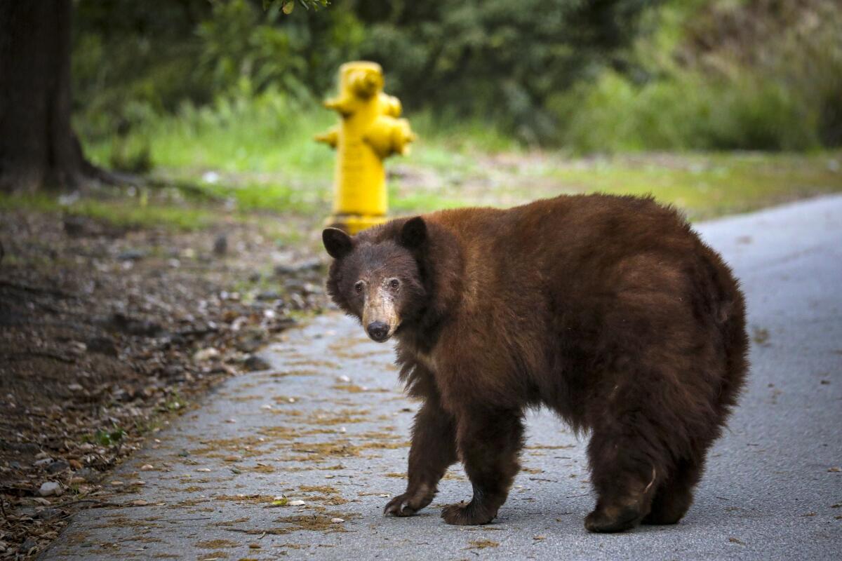
A black bear wanders along Canyon Road in March 2020 in Arcadia.
(Irfan Khan / Los Angeles Times)
Anyone who hikes in Angeles National Forest is likely familiar with Red Box Picnic Area. It’s where adventurers park to hike up to Strawberry Peak or other nearby trails, like the Gabrielino Trail, which I wrote about last week. That’s how I found myself briefly stranded in the forest.
I had spent the day hiking past gorgeous wildflowers and splashing around in the Arroyo Seco. I got back to my car around 7:30 p.m., discovered my car’s battery was dead and, after realizing I had cellphone reception, called for help.
As I waited, I chatted with a good Samaritan, an outdoors woman reading a book in her car who decided she’d wait with me until a service technician arrived.
The bear arrived in the lot around 8:30 p.m. As the sun dipped lower into the horizon, we watched the hungry fluffball knock over the brown metal trash can that was specifically designed to keep its species out.
A bear with its head inside a bear-proof trash can.
(Jaclyn Cosgrove / Los Angeles Times)
After knocking the trash can down, the bear easily shoved its arms inside. Over the next several minutes, it repeatedly shook the can toward its (adorable) face. It was kind of like watching a human shake a potato chip bag toward their mouth to get the very last bits of delicious fried starch.
My new friend and I agreed, in all our travels throughout California, we hadn’t seen anything like this. I contacted the California Department of Fish and Wildlife to ask them: How normal is it for a bear to deftly navigate the mechanisms of a trash can built to resist it?
“It’s pretty uncommon that the bears actually break in,” agency spokesman Cort Klopping said. “When I was talking to our biologist about it yesterday and a couple people in the office, the reactions were all kind of like, ‘Wow.’ Either somebody didn’t secure that thing or that bear was an absolute hulk of a bear to get into a bear-proof or bear-resistant trash can. … I was joking with the biologist that I think I’ve actually had trouble opening those.
“You were witness to what I would refer to as a pretty rare sight,” Klopping added.
I’d known there was a bear in the area when I started my hike earlier that day. At Switzer Picnic Area, I read signs posted around the picnic tables warning visitors, “Active Bear Area: Do not feed bears or leave food unattended.” The flier featured an image of a bear standing on a picnic table, eating through some family’s meal.
A sign posted at the Switzer Picnic Area in Angeles National Forest.
(Jaclyn Cosgrove / Los Angeles Times)
Angeles National Forest spokesperson Keila Vizcarra said in an email that since last August, forest officials have received at least four reports from the public and staff about two bears active in the Switzer area.
Earlier this month, recreation staff spotted two bears at the Switzer Picnic Area eating food left unattended at a picnic table. They notified state wildlife officials.
“The animals may be the same bears seen last year, but it is difficult to confirm because tag numbers are not always visible or provided; in this case, one of the bears did not appear to be tagged,” Vizcarra said.
Forest staff use various hazing methods to discourage bears and other wildlife from eating human food, like making loud noises, securing or repairing trash cans and educating visitors about how to keep their food safe from animals, she said.
“A major contributing factor continues to be unsecured or unattended food, which attracts bears from long distances,” Vizcarra said.
The bear at Red Box finished its trash-inspired tasting menu and then walked past our cars. We both honked, but it was so unfazed, I wondered aloud whether it was deaf. (It wasn’t.)
It then headed south from the parking lot, and we didn’t see it again. I had already planned to write this week’s newsletter about that experience.
Then I went backpacking as a little treat to myself.
On Friday afternoon, my dog, Maggie May, and I headed out from near Pasadena down the Gabrielino Trail with a plan to camp overnight at the Gould Mesa Trail Camp. Despite loving the outdoors, I’d never been backpacking, but after my parents bought me a tent and sleep pad for my birthday in late May, I was itching to go. Gould Mesa is close to a city. It’s next to the Arroyo Seco with water to filter and reachable by a short two-mile mostly flat hike. It felt like the perfect first trip.
About a mile in, a mountain biker warned us of a “big bear, really big bear” at the campground before he sped off. A female hiker told me the bear was average, probably 5 feet on its haunches. Others hadn’t seen it.
I was talking to another mountain biker, who was telling me the bear had been active in the area for about a month, when a man came racing down the trail, shouting about how the bear was aggressive and dangerous. The man said he’d lunged at the bear, trying to protect his food, and proceeded to make several choices that would likely be found on a “What not to do when you encounter a bear” list. Maggie and I continued onward.
We arrived at the campground around 4:30 p.m. and didn’t see anything. I asked a mother and son set up at the site next to mine about the bear, and they pointed to a large coast live oak where a small, young bear laid over a thick branch, its small feet dangling down, right above the trail. One reason hikers hadn’t seen the bear was that they’d walked right under it.
A young bear lies on the branch of a large coast live oak above the Gabrielino Trail near Pasadena.
(Jaclyn Cosgrove / Los Angeles Times)
The bear had entered the campground from near the river, and without the mother-son duo realizing that the bear was approaching them, it grabbed their food right off their picnic table. The mom told me that she considered trying to pull the food back, but the bear made noises suggesting that it preferred she didn’t. It then left the campground, and presumably after eating the meal that her son told me had “a lot of protein” in it, the bear climbed into the tree and took a nap.
I’d camped in areas with bears before, including in Kings Canyon National Park where bears came into the campground every night. This bear wasn’t being aggressive. Instead, it seemed young and like it was testing out how easy it was to get food from these weird animals — we humans — in its backyard.
I decided to stay, especially after the bear left around 7:30 p.m., and none of us saw it again. The campground was full, and two of us, myself included, had bear spray.
Maggie and I got into the tent around 9 p.m. and soon fell asleep to the sweet serenade of frogs and toads singing their nightly songs.
Then, at 2:39 a.m., I woke up to the sound of something slapping the corner of my tent next to my head.
“What the f—?” I screamed.
I lay there, heart racing, listening.
I had put my tent’s rain fly on, so I couldn’t see outside, but I could hear the bear as it left. A large whoosh-whoosh sound headed away from my tent.
For the next 20 minutes, I listened intently to every single sound the forest made. Then, after checking that my bear spray and satellite communicator were close by, I fell back asleep. In the morning, I found a small cut in my rain fly that the bear’s paw had left. My dad later suggested that I date the hole with a marker.
A small cut left after a bear swiped the rain fly of Wild writer Jaclyn Cosgrove’s backpacking tent.
(Jaclyn Cosgrove / Los Angeles Times)
Maggie and I left around 10:30 a.m. to beat the day’s heat. Once at my car and with strong cellphone reception, I must admit that I opened ChatGPT. I don’t have a bear biologist on speed dial — yet! — and I wanted to talk to someone about why the bear hit my tent.
I explained that there wasn’t any food or toiletries in my tent. I had packed everything inside a bear canister that I then placed inside the bear vault in the campground. The chatbot and I soon agreed: This bear was likely making its rounds for a late-night snack, hoping someone had dropped a marshmallow or hot dog, when it encountered my tent. Maybe my tent was in its way. Maybe it looked weird.
Later, I called Klopping with the California Department of Fish and Wildlife again.
When we’d spoke earlier in the week about the trash-can bear, I’d asked him whether that bruin was at risk of euthanasia.
I told him that Goldie, a mama bear euthanized by the state earlier this year after swiping at and injuring two people, was top of mind for me, along with Victor, a beloved bear in Mammoth who was euthanized in 2024.
Goldie was the first California black bear to be euthanized in 2026, Times staff writer Clara Harter reported. “There were two bears euthanized in 2025, three bears in 2024 and five bears in 2023, according to Fish and Wildlife,” Harter wrote.
Klopping said the trash-can bear was just out for an easy meal and would be classified as a “no harm, no foul bear,” defined by the agency as “a bear that has strayed into an area where an incident could occur, has not engaged in nuisance activity or caused property damage, and may require assistance to return to nearby suitable habitat.”
He said it was unlikely, based on what I reported, that the bear would be moved since it was already in a forest far from any neighborhood. Instead, the only action would probably be that someone secure the bear-proof trash can so it actually functions properly. (Sorry, bear.)
“As much as I don’t want to say it, this bear is doing bear things,” Klopping said. “This is a natural thing for a bear to do. It’s searching out calories to sustain itself — they’re there, readily available. This bear knows how to get to them.”
When I called Klopping back to talk about the bear (or bears) at the campground, I was more worried. I reported the incident through the agency’s website because I know its biologists use the data for several reasons, including discerning when to implement bear-resistant measures in an area or relocate a bear. But again, I worried about what would happen to the bear or bears.
A black bear peeks its head around the vault toilets in the Red Box Picnic Area in Angeles National Forest.
(Jaclyn Cosgrove / Los Angeles Times)
Klopping had told me it was rare for the agency to euthanize a bear: California Department of Fish and Wildlife received 2,735 calls and reports regarding black bears in 2025, including some duplicates where multiple people were reporting the same incident, compared with the two bear euthanizations that same year.
During our second call, he told me that a biologist would review the report I made and might call me to get additional information, but again, this wasn’t “aggressive” behavior, he said.
When bear yearlings separate from their mothers at around 18 months old — which often happens in June — Klopping said the agency will get reports of these adolescent bears wandering closer to populated areas.
“You would use the term ‘testing boundaries’ — that may have been exactly what happened here,” he said. “Odds are pretty good you probably scared it just as much as it scared you.”
I hope the bears I encountered soon return to foraging for forest delicacies that don’t come in fast-food wrappers.
As interesting as last week was, I really hope the only bears I see the rest of the summer are at the pride festivals I attend. They’re absolutely welcome to go camping with me!
3 things to do
Cyclists ride down an open street at a previous CicLAvia event.
(CicLAvia Los Angeles)
1. Frolic through the streets in South L.A. CicLAvia will host a free car-free open streets event from 9 a.m. to 4 p.m. Sunday through the Leimert and Exposition Park neighborhoods. The 3.6-mile pop-up park includes a short segment of Crenshaw Boulevard and mostly stretches along Martin Luther King Jr. Boulevard from Crenshaw to Figueroa Street. Visitors are welcome to walk, skate, bike, play and explore along the route. For more details, visit ciclavia.org.
2. Celebrate Pride along the river in Long Beach Friends of the L.A. River will co-host an LGBTQ Pride nature walk from 10 a.m. to noon Saturday through the Dominguez Gap Wetlands with the California Native Plant Society South Coast Chapter. Plant enthusiast Tory Jaimez will guide the walk, teaching participants about local ecology. Register at support.folar.org.
3. Listen to the birds in Huntington Beach We Explore Earth, a local outdoors community group, will co-host with Save Orange Hills and Friends of Shipley Nature Center a peaceful bird walk from 8:30 a.m. to 11:30 a.m. Saturday at Shipley Nature Center in Huntington Beach. Guides will help participants learn about local bird species and ecosystems. Register at eventbrite.com.
The must-read
Perched atop a tall pine tree, resident bald eagles Jackie, left, and Shadow protect their latest offspring in their 5-foot-wide nest. The nest is viewable via a live feed from the nest cam.
(Gina Ferazzi / Los Angeles Times)
Friends of Big Bear Valley, the nonprofit behind a popular eagle nest camera, is rushing to raise $10 million by July 31 to buy land that could become a lakeside gated community, leading to the destruction of crucial habitat that celebrity birds Jackie and Shadow use for foraging, along with other wildlife who call it home. Times staff writer Lila Seidman wrote that if the nonprofit can raise the money, then the San Bernardino Mountains Land Trust would conserve the roughly 63 acres and might transfer it to the U.S. Forest Service (a common practice of land conservancies). That’s if they meet the July deadline. “Failure is not an option,” said Jenny Voisard, media and website manager for Friends of Big Bear Valley. “We’re not going to let them build on it.”
Happy adventuring,
P.S.
After Goldie the bear was euthanized, lawmakers listened to the public’s demand for a more transparent process of when the California Department of Fish and Wildlife plans to kill a bear that the agency has deemed a threat to public safety. That includes Senate Bill 1135 by state Sen. Catherine Blakespear (D-Encinitas) that would “create the Wildlife Coexistence Program, which would provide public education, offer technical assistance and maintain a statewide incident reporting system. It would help communities deploy nonlethal devices to deter predators, like barriers or noise and light machines,” former Times staff writer Katie King wrote. The bill is set to have a hearing before the state Assembly’s Committee on Water, Parks and Wildlife on Tuesday at the state Capitol. Although the deadline to submit a letter to the committee has passed, residents can still attend the hearing, where they’re allowed to give their name, organization (if with one) and their position on the bill. You can still also contact your Assembly member or the committee.
For more insider tips on Southern California’s beaches, trails and parks, check out past editions of The Wild. And to view this newsletter in your browser, click here.
PHILADELPHIA — The Trump administration can replace a slavery exhibit at George Washington’s home in Philadelphia, a federal appeals court panel said Thursday, striking down a lower court’s injunction that required the National Park Service to reinstall the interpretive panels.
The unanimous ruling by the three-judge panel of the 3rd U.S. Circuit Court of Appeals said a lower court judge wrongly interpreted Philadelphia’s contract claims involving Independence National Historical Park, saying the city merely having standing to sue did not mean its arguments had merit. The panel also praised the plans for the replacement installation, writing that they were “full of historical context,” despite objections from historians and city officials that the content appears whitewashed.
The ruling comes a week after a Massachusetts federal judge ordered the Trump administration to restore sites changed under an executive order calling for the nation’s museums, parks and landmarks to not display elements that “inappropriately disparage Americans past or living.” The federal government has asked for a stay on that ruling while it appeals.
It was unclear how the Massachusetts ruling would affect the restoration or replacement of the panels at the President’s House Site. About half the large panels at the outdoor exhibit had been restored before a February pause in the work.
Messages to spokespeople for the Department of Interior and the National Park Service were not returned.
In a statement on Instagram late Thursday, Philadelphia Mayor Cherelle Parker vowed to pursue legal avenues to reverse the decision.
“We cannot and WILL not rest until the full story of American history – including the existence of Slavery at the President’s House here in Philadelphia – is told, for our Nation and the World to see,” she wrote.
Dawn Chavous, a volunteer for Avenging the Ancestors Coalition, one of the advocacy groups that helped develop the site in the 2000s, said they are disappointed with the decision but are speaking to their attorneys and considering options.
“For decades, ATAC has worked to ensure that the stories of the enslaved African descendants who lived and labored at the President’s House are not erased, overlooked, or misrepresented,” the group said in an emailed statement. “That commitment remains unwavering. We believe that historical truth matters, and we will continue to advocate for the protection, preservation, and accurate interpretation of this important chapter of American history.”
The city of Philadelphia sued in January after the National Park Service, in response to President Trump’s executive order, removed the explanatory panels from the President’s House Site, where George and Martha Washington lived with nine of their slaves in the 1790s, when Philadelphia was briefly the nation’s capital.
The city had worked in tandem with the federal government, historians and private partners to create the exhibit in the early 2000s — as part of a longstanding cooperation agreement over the downtown historical park — and contributed $1.5 million toward its creation.
The city argued that the federal government must consult with the city before making changes to the President’s House Site. Justice Department lawyers argued the administration alone can decide what stories are told at National Park Service properties.
In its ruling Thursday, the appeals panel said the maintenance portion of the contract between the city and the federal government could not be interpreted to mean the site would remain as it was when it was completed.
“The duty to ‘maintain’ is better understood as a general management obligation that accompanies ownership, not a promise that the exhibits will forever remain in place regardless of the owner’s wishes,” the opinion said.
Casey and Lauer write for the Associated Press. Casey contributed to this report from Boston.
I was only about 30 minutes from my home, but there I was in the solitude of the San Gabriel Mountains without another soul on the trail.
Dozens of butterflies, likely variable checkerspots with hints of yellow and red on their wings, fluttered all around. A territorial hummingbird repeatedly buzzed past my head, resembling the sound of either the world’s largest bumblebee or a tiny angry drone zipping past my face. Western whiptails flitted across the trail and onto rocks. A cacophony of birdsong and calls filled my ears, including, per my birding app, spotted towhee, Western wood-pewee, wrentit, bushtit and a purple finch I looked long and hard to try to identify in the treetops. Later, a gray squirrel expressed its displeasure at an interloper disrupting its peace.
These are special and common experiences that I frequently find hiking along the Gabrielino Trail, a 28(ish)-mile route through the San Gabriel Mountains that runs from Chantry Flat north of Arcadia to a lush riparian area along the Arroyo Seco east of NASA’s Jet Propulsion Lab near Pasadena. Although it offers hikers an epic close-to-home backpacking experience, you do not need to complete the entire trail to enjoy it.
Because of its length and proximity to other trails, it is replete with epic day-hike opportunities and, because of that, it’s a great place to spend the summer solstice, both the mark of the beginning of summer and the longest day of the year.
You are reading The Wild newsletter
Sign up to get expert tips on the best of Southern California’s beaches, trails, parks, deserts, forests and mountains in your inbox every Thursday
By continuing, you agree to our Terms of Service, which include arbitration and a class action waiver. You agree that we and our third-party vendors may collect and use your information, including through cookies, pixels and similar technologies, for the purposes set forth in our Privacy Policy such as personalizing your experience and ads.
This weekend, we will see just over 14 hours of sunlight on Friday, Saturday and Sunday. The sun will rise around 5:40 a.m. and set just after 8 p.m. It offers hikers the opportunity to not only travel longer distances, but also take rests along the way to really savor their surroundings.
In this edition of The Wild, our weekly outdoors newsletter, I will suggest a few routes along the Gabrielino Trail. I encourage you, though, to take a look at a paper map of Angeles National Forest (available at most local outdoors gear stores) or use a mapping service such as CalTopo or onX Backcountry to discern what would be the most fun for you and your hiking party.
Before we discuss the hikes, a few safety reminders:
🙅 Don’t drink water straight from the creek (unless in a serious emergency). Always use a filter or pack your own water.
🫗 Pack more water in summer than you would in other seasons. Dehydration can evolve into a serious and life-threatening situation.
🤮 Never relieve yourself in or next to a river, as it’s a major contributor to pollution; never leave toilet paper in the woods.
🥾 Wear water-resistant or waterproof footwear with good traction, and pack extra wool socks to better ensure you won’t get blisters.
📡 Bring a cellphone with satellite messaging capabilities or a satellite communicator to ensure you can call for help; you likely won’t have cellphone reception in the San Gabriel Mountains.
🤔 Freshen up on Leave No Trace principles and how to best pack your bag for the safest best day.
Additionally, please note that the segment of the Gabrielino Trail in and around the West Fork and Devore Trail camps was damaged in recent storms. The Lowelifes Respectable Citizens’ Club, a trail maintenance crew, is repairing it and hopes to have it online soon.
OK, here’s what I recommend along the Gabrielino Trail. Have fun out there!
A hiker meditates near the Brown Mountain Dam just off the Gabrielino Trail in Angeles National Forest.
(Jaclyn Cosgrove / Los Angeles Times)
1. Gabrielino Trail near JPL to Brown Mountain Dam (or beyond)
Distance: 7.6 miles Elevation gained: About 650 feet Difficulty: On the easier end of moderate Dogs allowed? Yes Accessible alternative: Paved segment of Gabrielino Trail from Windsor Avenue
This 7.6-mile out-and-back trek takes hikers along the Arroyo Seco, under the canopy of massive coast live oaks and past aromatic native plants such as California bay laurel.
You will park in the large dirt parking lot and take the steep paved road a very short jaunt to join the trail. If hiking with a wheelchair or if you’re a hiker who prefers pavement, it’s better to park in the lot south of the dirt lot.
Once on the Gabrielino Trail, you can hike as far as you’d like. Short on time? Hike two miles to Gould Mesa campground, have a little snack (and maybe a swim) and head back.
To reach the dam, follow the trail in the northwesterly direction for about 3.4 miles from the starting point. You’ll come to an intersection where the Gabrielino Trail continues northwest, leading you away from the river. Instead, you’ll want to follow the footpath along the river to reach the man-made-but-still-lovely waterfall.
1a. Want a longer day?
If you want a longer day, you could continue on the Gabrielino Trail after your side quest to the Brown Mountain Dam waterfall and ask a friend to pick you up at this gate off Angeles Crest Highway at a specific time. This point-to-point journey will be about 7.6 miles. The extension is also much more challenging than the first 3.7 miles, as it gains about 1,500 feet over 3.9 miles. This trail through Dark Canyon can be overgrown, so please plan accordingly, including downloading a map and bringing a paper map with you. (See map)
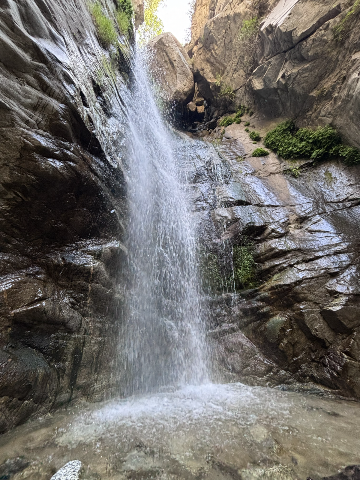
Switzer Falls in Angeles National Forest.
(Raul Roa / Los Angeles Times)
1b. Big adventure day
For an even longer point-to-point journey, leave the Brown Mountain Dam waterfall and take the Gabrielino Trail all the way to Switzer Falls, asking a friend to pick you up at the Switzer Picnic Area at a specific time. This point-to-point route will be about 11 miles, and you will gain about 2,350 feet in elevation. This is the most rugged option, and this trail can be overgrown in places. Plan accordingly! (See map)
The Gabrielino Trail, a 28-mile trek through Angeles National Forest, passes through various plant communities and canyons, providing pockets of shade along the way.
(Jaclyn Cosgrove / Los Angeles Times)
2. Red Box to Valley Forge Trail Camp via Gabrielino Trail
Distance: 4.8 to 6.6 miles, depending on your route Elevation gained: About 1,200 feet Difficulty: Moderate Dogs allowed? Yes Accessible alternative:Mt. Wilson Observatory paved walking path
This 4.8- to 6.6-mile out-and-back trek will take you along a delightful path that always feels a little bit like a fairy wonderland to me. You’ll pass under shady oak canopies and past moss-covered rock walls. You end at the Valley Forge Trail Camp, which has lovely tall conifers and a vault toilet (that’s usually clean).
To begin, you’ll park in the Red Box Picnic Area parking lot, which can fill up on the weekends and does require you to display an Adventure Pass or other federal public lands pass. You’ll find the trail’s start down some rock steps in the southern area of the lot.
Valley Forge Trail Camp, left, and mossy rocks.
(Jaclyn Cosgrove / Los Angeles Times)
Just over two miles in, you’ll near the trail camp. Take good care to ensure you’re on the right trail. Instead of following the Gabrielino Trail, keep your eyes peeled for the trail that descends toward the riverbed. After a nice rest at the trail camp, you can take the trail or fire road back. (See map)
As of mid-June, the Red Box Picnic Area is experiencing active bear activity, so be mindful if returning to your car around dusk.
2a. For those feeling hardcore
From near Valley Forge Trail Camp, you could consider taking the very steep Valley Forge Trail, a 2.6-mile trek that gains about 1,550 feet, to the Eaton Saddle. From here, you could take the Mt. Lowe Motorway to the San Gabriel Peak Trail, head north briefly using the Mt. Disappointment Road to take the Bill Riley Trail down to Mt. Wilson Red Box Road. The downside is that you’ll have to then take the road about a third of a mile down to Red Box, and drivers zoom through here like they suddenly learned burgers at In-N-Out are free for only the next hour. That’s to say: Proceed with caution.
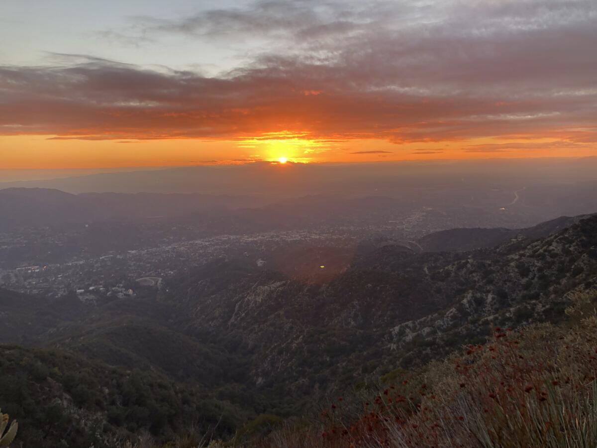
City lights glow after sunset in a view along the road to Mt. Disappointment in Angeles National Forest.
(Brian van der Brug / Los Angeles Times)
Additionally, parts of this trip extension might be overgrown. It is about 5.5 miles and gains 2,300 feet in elevation. It will be through a beautiful area of the forest though! (See map)
Regardless of which route you take, please make sure to check the weather, pack smart and be OK with turning around if the conditions on the trail aren’t passable. Additionally, please be mindful of trails that remain closed under the Eaton fire area closure order.
The stretch of the Gabrielino Trail between Red Box and Switzer picnic areas offers great views of nearby peaks in the San Gabriel Mountains.
(Jaclyn Cosgrove / Los Angeles Times)
3. Red Box Picnic Area to Switzer Picnic Area
Distance: About 8.6 miles Elevation gained: About 1,450 feet Difficulty: Moderate Dogs allowed? Yes Accessible alternative: West Fork National Scenic Bikeway
Earlier this week, I took this 8.6-mile moderate route, parking at the Red Box Picnic Area before heading down into the canyon on the segment of the Gabrielino Trail that runs parallel to Angeles Crest Highway. (See map)
This trail is both beautiful — lush with native plants and the last blooms of wildflower season with great views of nearby peaks — and exposed. There will be shady patches as you hike under healthy oak and maple tree canopy, but wear ample sun protection.
One of many deep pools along the rivers that run next to the Gabrielino Trail.
(Jaclyn Cosgrove / Los Angeles Times)
Although the trail runs parallel to the Arroyo Seco for a stretch, you cannot easily access the river because of a steep drop-off from the trail to the river. I didn’t cross the river until 3 miles in, and by then, I was feeling hot and ready for a quick dip.
That said, when I arrived at the Switzer Picnic Area, I felt like I’d won the lottery. I had skipped the nightmare that it has become to park here, but I still got to swim around in one of the river’s deep pools. It was 1.8 miles farther to Switzer Falls, one of the best cascades in Angeles National Forest.
Great views from the Gabrielino Trail.
(Jaclyn Cosgrove / Los Angeles Times)
***
If you have any questions or feedback about the suggested routes, you can simply reply to this email if you’re a Wild subscriber. It will go directly to me. I love hearing from you. Have fun out there and happy summer!
3 things to do
Volunteers work at a Channel Islands Restoration event.
(Channel Islands Restoration)
1. Serve the river in Santa Paula Channel Islands Restoration, a Santa Barbara-based habitat restoration nonprofit, needs volunteers from 9 a.m. to noon Sunday at Santa Clara River Preserve (1368 Mission Rock Road in Santa Paula). The preserve spans almost two miles and is about 1,000 acres. All ages and skill sets welcome. The site is ADA-friendly, and restrooms are on-site. Register at cirweb.networkforgood.com.
2. Eradicate invasive plants in Irwindale The California Native Plant Society San Gabriel Mountains Chapter needs volunteers from 8 to 10:30 a.m. Saturday to yank weeds from the Santa Fe Dam natural area. Volunteers will also learn from plant society members about the local flora and fauna. Learn more at chapters.cnps.org.
3. Investigate the invertebrates in Rowland Heights The Invertebrate Club of Southern California will host a 1.5- to 3-mile hike from 6:30 p.m. to 9 p.m. June 26 through Big Dalton Canyon. Participants will learn about scorpions, beetles and other interesting creatures. Learn more at the group’s Instagram page.
The must-read
The Malibu coastline just south of Point Dume.
(Jackie Snow)
Freelance writer Jackie Snow was feeling inspired to get outdoors. After reading my 2024 piece about walking the entire 27.4 miles of Washington Boulevard, she came up with an idea: Walking the entire L.A. County shoreline. Snow took 10 trips from November through mid-January to accomplish her goal, walking 70(ish) miles in total. She maps out in her piece how you can do that too! “I have seen whale-watch perches, burned-out Malibu lots, crowded boardwalks and magnificent waves. The coastline is both fragile and welcoming — and walkable — if you’re willing to chase the tides,” Snow wrote in her article for The Times.
Happy adventuring,
P.S.
It’s ladybug season in Los Padres National Forest. Volunteers with the Los Padres Forest Assn. recently discovered thousands of the insects while they were working on the Piedra Blanca Trail. “If you know where to look, you can find them hibernating on rocks, leaf litter, and trees in masses called ‘lovelinesses,’” the association wrote on Instagram. “But, have you ever seen the next generation hatch and fly away in the springtime?” No, but I hope to someday.
For more insider tips on Southern California’s beaches, trails and parks, check out past editions of The Wild. And to view this newsletter in your browser, click here.
I wanted to know more the moment I read “Sister Elsie Peak” on an old map.
I discovered the name while researching trails around Mt. Lukens, the highest peak in Los Angeles proper. Looking at the peak’s location on a historical map of L.A. County’s mountains, I noticed that it was previously named for a woman I’d never heard of.
Few of Southern California’s mountain peaks are named after women, so Sister Elsie Peak stuck with me. Who was she? And why was her mountain renamed to instead honor local leader Theodore Lukens?
In this edition of The Wild, our weekly outdoors newsletter, I will take you with me on my arduous journey to find the origins of the first known name for Mt. Lukens. Over the past week, I enlisted help from multiple librarians, map experts and one gracious historian (who you’ll meet later). We all scoured newspaper archives and history books, catching the fever of curiosity that seems to consume anyone who tries to find out who Sister Elsie was.
You are reading The Wild newsletter
Sign up to get expert tips on the best of Southern California’s beaches, trails, parks, deserts, forests and mountains in your inbox every Thursday
By continuing, you agree to our Terms of Service, which include arbitration and a class action waiver. You agree that we and our third-party vendors may collect and use your information, including through cookies, pixels and similar technologies, for the purposes set forth in our Privacy Policy such as personalizing your experience and ads.
What we collectively found was this: Sister Elsie was most likely not a real person, and her legend was most widely shared in the early 20th century by a local landowner who was known to embellish, including claiming that Josephine Peak near Mt. Lukens was named after his daughter. (It wasn’t.)
There appears to be no record anywhere — in newspapers, in history books, in Catholic Church records — as to the existence of a Sister Elsie or, as you’ll learn more about below, an alleged orphanage, ranch or school that she ran in the Tujunga area for Indigenous children or the broader Indigenous community.
In that same vein, I want to call something out before we begin: Stories about the relationships between colonizers and Indigenous peoples often get romanticized (see: Thanksgiving), with storytellers and early historians intentionally leaving out any details of forced assimilation or the American genocide. I cannot report anything concrete about how Sister Elsie actually treated Indigenous people in large part because I don’t believe she was real.
The sunset as viewed from a trail near Mt. Lukens in the San Gabriel Mountains.
(Jaclyn Cosgrove / Los Angeles Times)
OK, I’ve held you in suspense long enough. Let’s jump into everything under the actual sun that I could find about Sister Elsie Peak.
To begin my reporting, I contacted Times editorial library director Cary Schneider, who is always eager to help me with prospective stories (i.e. highly specific internet rabbit holes I’ve fallen down).
Cary found what might be the earliest mention in a local newspaper: A story in the Monrovia Daily News on April 23, 1910, in which a writer mentions a new trail leading to Sister Elsie Peak, but tragically gives no details of its namesake.
Next, we jump 20 years into the future when The Times and the Pasadena Star-News covered the dedication of Sister Elsie’s Well in Tujunga. Both publications described the well in their stories on April 28, 1930, as named after “the Catholic nun” who ran a school for Indigenous children “in the days of the Spanish missions.” The Times called her a “pioneer nun and teacher.”
Multiple radio towers and other infrastructure sit at the top of Mt. Lukens, as seen on a 2022 hike there.
(Jaclyn Cosgrove / Los Angeles Times)
The dedication occurred on the land of Philip Begue, a crucial character to understand in the Sister Elsie legend, as he’s believed to have either spread or made up the story, according to a local historian. Begue’s family bought land around Tujunga and La Crescenta in 1882, and later, Begue was an early pioneer and one of the first forest rangers in what would later become Angeles National Forest.
Throughout the late 1920s and 1930s, Begue seemed set on sharing the story of Sister Elsie. In 1934, he told the Pasadena Star-News that the sister “ministered to the sick and needy” Indigenous people.
A Times story on Sept. 29, 1935, announced a barbecue fundraiser for a local Catholic institution at the “old Basque rancho” owned by Begue. “The ranch on Honolulu avenue was famous in early days when Los Angeles was a pueblo and Sister Elsie had a children’s home where the ranch now stands.” The Begue family planned to cook “hundreds of pounds of meat for the affair.”
Times columnist Harry Carr offered in his column, the Lancer, a completely different take. Carr wrote on April 3, 1935, that Sister Elsie Peak was named “for a nun who lost her life trying to walk from San Fernando to San Gabriel.” No, he doesn’t provide a source for where he learned that information. Trust me: I too shook my fist at the sky.
The last rays of sun blanket across Mt. Lukens, as seen from Dunsmore Canyon in Deukmejian Wilderness Park near Glendale.
(Jaclyn Cosgrove / Los Angeles Times)
I would be remiss to mention that the oldest reference to a “Sister Elsie” in The Times’ archives appears to be an 1889 story about — buckle up — a psychic medium in Azusa. For a brief and beautiful moment, Cary and I hoped Sister Elsie Peak would turn out to be named after Elsie Wheeler, a spiritualist medium whose own story relates to an astrological tool. Alas, the peak was named before she was born (which doesn’t work unless she was a really good psychic). That said, a peak named after a mythical nun and a clairvoyant feels arguably appropriate for the highest point in L.A.
Cary also discovered one of my favorite facts about the Sister Elsie legend — that it was turned into a play titled “Sister Elsie in Tujunga.” It was written by Frances Muir Pomeroy, superintendent of summer school at Our Lady of Lourdes Catholic Church. It was said to be about “the experiences of Sister Elsie when she conducted an orphanage here many years ago,” according to a 1938 Times story.
There are other references to Sister Elsie in The Times’ archives over the next several decades, but nothing that gives concrete evidence that she actually existed.
Cary advised me to contact the Los Angeles Public Library. Librarian Kelly C. Wallace, who specializes in California history, quickly got back to me.
Knowing that Cary had already scoured The Times’ archives, Wallace sifted through the agency’s Los Angeles Area Historical Newspapers database, which contains the Los Angeles Daily Star (1870-1879), the Los Angeles Evening Post-Record (1896-1936) and the Los Angeles Star (1851-1871), along with community newspapers such as the Eagle Rock Sentinel and the Highland Park Herald. She found little there.
The trail through Stone Canyon to reach Mt. Lukens.
(Mary Forgione / Los Angeles Times)
This is especially puzzling if Sister Elsie did exist because, before the advent of television, newspapers reported seemingly everything that we now post on social media — detailed trip reports, the attendees of parties, birth announcements, and even basic road repairs.
Wallace did discover a few interesting tidbits in books, but curiously nothing before 1930.
The earliest reference that Wallace found was in the 1938 book “History of La Crescenta-La Canada Valleys” by Grace J. Oberbeck. She spoke to Begue, who spun quite the yarn:
“On El Rancho de las Hermanas, the ranch of the sisters, a group of nuns who had an orphanage not far distant, kept a herd of cows which was looked after by” local Indigenous people “who supplied milk to the school whenever needed. Sister Elsie was the much loved nun in charge of” the Indigenous dairy workers, “and her name was given to the well. Almost directly north from here towers a high peak of the Sierra Madre range and this bears the name of Sister Elsie Peak.”
Legendary outdoors writer and historian John W. Robinson, Wallace found, told the Sister Elsie story in his 1977 book “The San Gabriels,” but followed it up with a correction in his 1983 tome, “The San Gabriels II”: “The derivation of Mt. Lukens’ original name, Sister Elsie Peak, is clouded in uncertainty. Exhaustive research into Catholic Church records fails to find any evidence of a nun named Sister Elsie nor an orphanage named El Rancho de Dos Hermanas.”
You’re telling me, John!
Wallace also found an entirely different story about Sister Elsie on page 47 of “The San Fernando Valley” by Jackson Mayers, published in 1976.
“Sister Elsie, a Sister of Charity, came to Tujunga from Los Angeles between 1850 and 1875 to work with” Indigenous people “at a school and orphanage. Near Haines Canyon was Sister Elsie’s well; Sister Elsie’s Peak was named, it is said, because when troubled she would gain strength by raising her eyes to that eminence, one whose top she was to be buried. Others held that two nuns on their way from Mission San Fernando to Mission San Gabriel lost their way in Tujunga and died atop the peak.”
There is tragically no footnote on the page, so I have no idea who Mayers’ source was.
I hoped that finding out when Sister Elsie Peak was named would help, but that also proved to be a dead end.
Local historian Mike Lawler, former president of the Historical Society of the Crescenta Valley, told Realtor Sharon Hales in a 2016 interview that cartographer George M. Wheeler and his team named the mountaintop Sister Elsie Peak during their survey of California in the late 1800s.
“We don’t know why he named it Sister Elsie Peak,” Lawler said. “The reasons why he named everything are lost to history. They were destroyed in the 1906 San Francisco earthquake.”
This led me to contact the staff at the David Rumsey Map Center at Stanford University Library, as its collections are vast, and I hoped maybe they’d somehow find half a charred page of notes with Sister Elsie’s biography scrawled in quill pen.
Instead, Kristina Larsen, the center’s associate curator, came up short, finding only that a misspelling, “Sister Else Pk” was on the 1881 land classification map from Wheeler.
Evan Thornberry, the center’s head and curator, unearthed “Vignettes of California Catholicism,” a 1988 book by Monsignor Francis J. Weber, longtime archivist for the Archdiocese of Los Angeles at the San Fernando Mission.
Weber conducted an exhaustive search for the existence of Sister Elsie and found no proof of any existence of Sister Elsie or a Catholic orphanage in the Tujunga area at the time.
Weber offered my favorite suggestion for why no one can find any hint of Sister Elsie’s existence: “Maybe the good Sister was kidnapped by Martians!”
If so, I hope someone there takes better care to protect knowledge regarding the names of that planet’s mountains.
You’d think I’d give up here, right?
Instead, I contacted historian Kristine Gunnell, who wrote “Daughters of Charity: Women, Religious Mission and Hospital Care in Los Angeles, 1856-1927” (Vincentian Studies Institute).
I hoped Gunnell would have an answer, as Sister Elsie was said to be in the Sisters of Charity, an American version of the Daughters of Charity, a group that was founded in France in the 1600s with an aim of serving low-income and sick people.
The Daughters group eventually inspired American Catholic women to serve in a similar way, first forming the Sisters of Charity until the groups essentially merged. In the 1850s, as more people moved to the American West, a bishop in the L.A. area requested that Daughters of Charity come to L.A., Gunnell said.
But, there’s no Sister Elsie referenced in Gunnell’s book.
Gunnell said after hearing from me, she contacted a history professor from DePaul University who is compiling a database about all the Daughters of Charity who served in California. He found no one referred to as “Sister Elsie” between 1850 and 1900.
A 1931 news story references that Sister Elsie treated Indigenous children diagnosed with typhoid fever.
Tujunga “was only a day’s wagon ride from Los Angeles, and if these Tongva were Catholic or had Catholic connections, the sisters may have considered their request,” Gunnell wrote to me. “I was hoping that I’d be able to find a record of the typhoid outbreak in Tujunga in the 1860s or 1870s and cross reference it with the Daughters’ records. It’s a good story, and the sisters likely would’ve reported it if it’s true. However, I can’t isolate a specific outbreak.”
Later, Gunnell and I hopped on a Zoom call to commiserate.
With all of our research before us, we reached the same conclusion: A Catholic sister could have feasibly traveled to Tujunga at the request of a bishop to help Indigenous people, but currently there is no record of a woman known as Sister Elsie who did so. There’s no record of much of anything told in the Sister Elsie story. It seems, instead, to have been an urban legend of its time.
At least for now.
Hikers in Elysian Park.
(Dania Maxwell / Los Angeles Times)
3 things to do
1. Reach for the rainbow in L.A. One Down Dog, an L.A. yoga and fitness studio, will host a Pride hike from 10:30 a.m. to noon Saturday in Elysian Park. Guests will hike a loop trail through the park. For more details, register at eventbrite.com.
2. Marvel at mollusks in Malibu The Wishtoyo Chumash Foundation will host a tidepooling event from 8 a.m. to 1 p.m. June 19 near the Wishtoyo Chumash Village (33904 Pacific Coast Highway) in Malibu. Guests will learn about Wishtoyo Village, which is typically not open to the public. All experience levels welcome. Learn more at the foundation’s Instagram page.
3. Learn along the L.A. River in Downey The California Native Plant Society and Friends of the L.A. River will host a guided bike ride along the L.A. River. Naturalist Cris Sarabia will teach participants about local ecology during the ride. Binoculars will be provided. Guests should bring safety gear and water. Learn more at the group’s Instagram page. Register at folar.org.
The must-read
Burn damage to the Torrey pine grove at Santa Rosa Island.
(Kayla Bartkowski / Los Angeles Times)
The length of time that it will take for Santa Rosa Island to recover after a blaze scorched about one-third of the island remains unclear, Times staff writer Grace Toohey wrote after a recent visit to the island. The fire, which grew to 18,379 acres, is now fully contained. Firefighters faced vicious winds and, at times, 30-foot flames. “They held the line, and we have them to thank for saving housing, saving the island, saving the history of the Santa Rosa Island,” said Ethan McKinley, superintendent of Channel Islands National Park. The island has long been a respite for hikers and backpackers, including Times staff writer Lila Seidman, who shared her experiences on the island and her grief that came in the wake of the blaze. “Now fear clouds the memories: Does the rugged, magical place of my mind’s eye still exist?” Seidman wrote.
Happy adventuring,
P.S.
I have a flurry of good California animal news to share. First, three mule deer were the first animals to walk over California’s first wildlife crossing over State Route 97 in Siskiyou County. Second, scientists have feared that the population of endangered steelhead trout in the Santa Monica Mountains were killed in massive debris flows after the Palisades fire. However, researchers recently spotted the fish — and their babies — in Topanga Creek. And finally, the California Department of Fish and Wildlife shared earlier this week that five orphaned black bear cubs that were rehabilitated and released into northern California in November successfully hibernated through the winter and returned to the landscape this spring healthy and active, according to recent data reviewed by the agency’s scientists.
For more insider tips on Southern California’s beaches, trails and parks, check out past editions of The Wild. And to view this newsletter in your browser, click here.
I was alone in the forest in my favorite place for the first time in years, so I did the only logical next right thing. I lay down.
There I was, sprawled next to Millard Canyon Falls, listening as the water roaring down the cliff and cool air whooshed past my face. I gained a new perspective when I gazed at an upside-down waterfall. What’s the point of hiking if we don’t play around?
In today’s edition of The Wild, our weekly outdoors newsletter, I provide you with three great hikes where rivers and waterfalls are still flowing. It’s essential information as we head into summer and temperatures start to rise.
You are reading The Wild newsletter
Sign up to get expert tips on the best of Southern California’s beaches, trails, parks, deserts, forests and mountains in your inbox every Thursday
By continuing, you agree to our Terms of Service, which include arbitration and a class action waiver. You agree that we and our third-party vendors may collect and use your information, including through cookies, pixels and similar technologies, for the purposes set forth in our Privacy Policy such as personalizing your experience and ads.
If you were to force me to choose my favorite hike, I would stubbornly refuse to pick just one, but my list would include these three.
That’s why I really want to urge you, my dear Wild reader, to treat these places with the reverence they deserve. That includes:
Refreshing your memory on the seven “Leave No Trace” principles.
Packing a small trash bag in which you can store empty food wrappers, toilet paper and garbage you spot along the way.
Observing wildlife from a distance, including California newts, which you shouldn’t pick up because it’s rude and, more important, because they can secrete a neurotoxin through their skin that can be lethal to humans.
OK, let’s talk about where your next favorite hike will be!
Millard Canyon Falls in Angeles National Forest.
(Jaclyn Cosgrove / Los Angeles Times)
1. Millard Canyon Falls
Distance: 3.3 to 4.3 miles (see below) Elevation gained: About 900 to 1,100 feet Difficulty: Moderate Dogs allowed? Yes Accessible alternative: Paved segment of Gabrielino Trail from Windsor Boulevard
This 3.3- to 4.3-mile hike to Millard Canyon Falls will take you through lush hillsides and beneath the shade of coast live oaks and bigleaf maples as you walk alongside, and sometimes through, Millard Creek. Your journey ends at Millard Canyon Falls, a gorgeous 50(ish)-foot waterfall that gushes past massive boulders perched at the top of the cascade.
This hike is usually much shorter (about 1.5 miles), but a road closure in place since the Eaton fire lengthened it. I will explain more about the closure later. It is important to note, though, that Chaney Trail is the name of the roadway and an actual trail, both of which you’ll take on this hike.
To begin your hike, you can either parallel park nearNuccio’s Nurseries, taking care to obey all parking signage, or if those spots are all taken, park nearby and order a rideshare to drop you at the trailhead. I had cell reception with Verizon here, so it should be possible to order a ride back to your vehicle.
Millard Creek in Angeles National Forest.
(Jaclyn Cosgrove / Los Angeles Times)
From here, you have two options for reaching the Millard Canyon Falls trailhead.
1. Follow Chaney Trail road for about 1.66 miles to the Millard Canyon Falls trailhead. This route will be exposed, so you’ll need to start early if you choose this option.
2. Walk about half a third of a mile north from Nuccio’s, and then, near a bend in the road, you’ll take the Chaney Trail, a winding dirt path that I was delighted to find is in great shape. (Shout out to Restoration Legacy Crew, a volunteer trail maintenance group, for its amazing work in the Millard Canyon area!)
That trail is a bit overgrown in a few spots, so you’ll want to wear pants (or take the road). Additionally, make sure to lightly stomp before heading into overgrown areas, as this helps alert any snakes snoozing in the shade of your presence.
The view from the ground looking up at Millard Canyon Falls.
(Jaclyn Cosgrove / Los Angeles Times)
You’ll take Chaney Trail for about half a mile, pausing to catch your breath and take in the increasingly great views of the San Gabriel Valley. You will next cross over Mt. Lowe Motorway to take the Sunset Ridge Trail down. (See map for greater detail.)
You will boogie down a few switchbacks for 0.7 miles, enjoying shade provided by bay laurels and sumac trees, listening to the sweet songs of canyon wrens and spotted towhees. (That’s who was singing to me, anyway!)
You will reach the Millard Canyon campground, which is closed for overnight camping but does feature a few nice picnic tables shaded by massive coast live oaks. With the creek flowing nearby, I wouldn’t blame you if you stopped and had a little snack here.
Millard Campground in Angeles National Forest. It is closed because of damage from the Eaton fire.
(Jaclyn Cosgrove / Los Angeles Times)
That said, you have finally made it to the Millard Canyon Falls trailhead! Just northwest of the campground, you’ll find a little arrow pointing you northward onto the trail. From here, you will gain minimal elevation, and can actually just frolic. It is about half a mile to the waterfall.
As I mentioned, this trail is usually shorter and easier to access, as there’s a large parking lot near the trailhead and more parking along the roadway.
The roadway Chaney Trail was slated to reopen at the end of April. I frequently checked Los Angeles County Public Works’ road closure website, as I had planned to write about Millard Canyon once the road reopened. But when I checked the website, I saw that the reopening had been moved to the end of August. Huh?
I asked the public information officers at county Public Works about it and was told: “We are currently coordinating with our on-call emergency contractor to complete guardrail repairs on Chaney Trail, just north of the gate. Construction is anticipated to begin in July and be completed by the end of August, weather and field conditions permitting.”
Clockwise from top left: prickly phlox, golden yarrow, cliff aster and a type of larkspur. Center: A little bird on a dried out plant.
(Jaclyn Cosgrove / Los Angeles Times)
I passed a shiny new guardrail just north of the gate when I was hiking there earlier this week. I asked the agency whether there was some other guard rail missing. No, my friends. “The community raised concerns about the roadway narrowing included in this project, and we will be reconstructing the guardrail to address those concerns,” a spokesperson told me via email.
And now ends the saga of the Chaney Trail guardrail.
As for Millard Canyon, I will admit, it quite possibly is my favorite frontcountry natural areas. I was reminded of this fact when I visited this week. Although the road closure adds some steep mileage to reach the canyon, it’s worth it to me. I will be back. I hope to see you there!
The Fish Canyon Narrows near Castaic.
(Jaclyn Cosgrove / Los Angeles Times)
2. Fish Canyon to Fish Canyon Narrows
Distance: About 5.5 miles Elevation gained: About 400 feet Difficulty: Moderate Dogs allowed? Yes Accessible alternative:San Francisquito Creek Trail
To reach the Fish Canyon Narrows, you will take the Fish Canyon Trail (called Forest Route 6N32 or the Warm Springs Fish Canyon Truck Trail on some maps) on a 5.5(ish)-mile out-and-back journey. You will ascend into narrowing walls of sandstone, granite and conglomerate. A healthy stream flows throughout the canyon, giving you ample opportunity to cool off or have a picnic in a naturally occurring sound bath (which, when you’re lucky, will include a tree frog).
A quick note: This is the most rugged (read: least curated) of the three adventures mentioned in this list. There is no trail signage, and you’re in a less popular corner of Angeles National Forest. You might be entirely alone, especially if you hike this on a weekday. You should plan accordingly. Or skip it if I’ve already freaked you out. (I do this out of love!)
To begin, you’ll park on the road’s shoulder, and head east through a gate. Follow the roadway north and then south as it curves toward a dirt path. Follow the exposed dirt path northeast. You’ll trudge through multiple water crossings and be blessed with the occasional shade of sycamore trees.
The narrows are often cooler than the rest of the area. The first portion of this hike has little to no shade, so make sure to wear plenty of sun protection.
And if you leave the trail but aren’t ready to go home, head over to the swim beach at Castaic Lake. And if you’re not tired, there’s always the Cali Splash Park, a massive inflatable floating park. That’s a full day of adventure!
A hiker lies near the creek along the Icehouse Canyon Trail.
(Brian van der Brug / Los Angeles Times)
3. Icehouse Canyon Trail to Icehouse Saddle
Distance: Around 7 miles Elevation gained: 2,600 feet Difficulty: Challenging Dogs allowed? Yes Accessible alternative:West Fork National Scenic Bikeway
Icehouse Canyon Trail to Icehouse Saddle is a 7(ish)-mile trek that runs mostly parallel to the gorgeous and crystal clear Icehouse Creek, which often features several short waterfalls as the water rockets down the mountainside.
As they trek through the canyon shaded by bigleaf maple, California incense-cedar and bigcone Douglas-fir, hikers might spot wildflowers including orange-yellow western wallflowers, light purple Grinnell’s Beardtongue and red western columbine.
Icehouse Canyon is popular on weekends and is best visited on a weekday if you can swing it. You’ll need either a $5 Adventure Pass, an annual America the Beautiful pass or other federal public lands pass to park.
To begin your hike, you’ll park at or near the trailhead — in the parking lot if it’s your lucky day. Otherwise, you’ll park along the roadside, taking good care to read signage and not block anyone’s driveway. Once while walking to the trailhead, I was greeted by a local dog whose collar informed me that he was allowed to meander about and knew how to get back home. I love small mountain towns.
After you park — and remember to display your pass, as forest service workers do ticket vehicles without them — you’ll head east to the trailhead.
A visitor cools down in the creek at Icehouse Canyon.
(Jaclyn Cosgrove / Los Angeles Times)
Immediately upon entering the canyon, you’ll be greeted with stunning beauty. Try not to become too distracted by the pools of water surrounded by large boulders. (No one will know if you skip the hike and just take a dip.)
About a mile into your hike, you’ll come to a crossroad where the Chapman Trail and Icehouse Canyon Trail intersect. Continue east on the Icehouse Canyon Trail. A mile farther, you’ll start the switchback portion of the trail, where you’ll gain about 1,200 feet in 1.5 miles. It’s a beautiful suffer fest.
Icehouse Saddle will offer you incredible views of the San Gabriel Mountains and Mojave Desert. You’ll likely meet other hikers here who are planning to continue their journeys to one of several peaks reachable from the saddle, including to popular spots like Cucamonga and Ontario peaks.
Hikers meander past boulders and large pine trees.
(Brian van der Brug / Los Angeles Times)
It can be quite windy at Icehouse Saddle, so if you’re planning to have your lunch here (which I’ve done many times), consider packing a windbreaker.
The Times has been writing about hiking in Icehouse Canyon for more than 100 years, as city dwellers have long been drawn to its beauty. A July 1926 article about Icehouse Canyon started with a headline declaring, “Here’s a nice cool trip” in all caps.
“It is a trip which one will want to take more than once when its lure has gotten into the blood,” an unnamed Times journalist wrote.
May we all be so lucky to return again and again.
3 things to do
Docent Susan Hopkins leads a Pride Month hike during a previous year’s celebrations.
(L.A. County Department of Parks and Recreation)
1. Celebrate Pride across L.A. County The L.A. County Department of Parks and Recreation will host several events celebrating LGBTQ+ Pride throughout June. Almost 60 county parks are hosting events, including from 5 to 7 p.m. Thursday at Dalton Park in Azusa; from 5 to 7 p.m. Thursday at Dr. Richard H. Rioux Park in Stevenson Ranch; and from noon to 2 p.m. Saturday at Crescenta Valley Community Regional Park in La Crescenta. For a list of all events, visit parks.lacounty.gov.
2. Walk for peace in L.A. Los Angeles meditation nonprofit InsightLA will lead a free 12-mile Walk for Peace from 9 a.m. to 3 p.m. Saturday. The walk will start at Hollywood Forever Cemetery and end with community picnic at Tongva Park in Santa Monica. Register at insightla.org.
3. Repair trails in remote forest near L.A. The Lowelifes Respectable Citizens’ Club, a volunteer trail maintenance group, needs volunteers on Saturday and Sunday to help restore an overgrown segment of the Gabrielino Trail in Angeles National Forest. Volunteers will either ride gravel bikes down a 5.5-mile dirt road or hike in. Previous trail work experience not required. Register by emailing trailwork@lowelifesrcc.org.
The must-read
The aedes aegypti mosquito, called the “yellow fever mosquito,” is well-known for spreading nasty illnesses like its namesake and dengue fever.
(Sameer Neamah Mahdi / Associated Press)
Here’s a sentence I didn’t expect to write this year (or ever): Google would like to release up to 64 million sterilized male mosquitoes in California and Florida to help combat mosquito-borne illnesses such dengue, Zika, chikungunya and yellow fever. “Google says it can harness technology to optimize a concept that’s been around for decades, but hasn’t worked at a large enough scale with mosquitoes to rein in disease,” Times staff writer Lila Seidman reported. The project is called Debug —although Google could have gone with WiFly.
I’ll see myself out.
Happy adventuring,
P.S.
You’re sitting there thinking about your weekend, wondering, “Is there anywhere I could go dressed as a shark?” Why, yes, there is! The Cabrillo Marine Aquarium and Cosplay for Science will co-host the Science Entertainment Aquarium Convention from 9 a.m. to 4 p.m. Saturday at the aquarium (3720 Stephen M. White Drive in San Pedro). SeaCon 2026 will feature a beach cleanup, a fictional marine biology panel and a cosplay contest, along with much more. Learn more at the aquarium’s Instagram page. Have a jaw-some time!
For more insider tips on Southern California’s beaches, trails and parks, check out past editions of The Wild. And to view this newsletter in your browser, click here.
Seemingly at every single turn, a hiker blazed past me, ignoring any semblance of trail etiquette.
A house party near the mouth of the canyon blared music that reverberated throughout the hillsides, blocking any chance to hear birdsong. Although I’m nonbinary, I felt my gender rapidly evolving into grumpy old man.
“The privilege of living here,” I grumbled to myself. “Never hiking on Memorial Day ever again.”
Then, I realized just how much my own attitude was ruining what could otherwise be a beautiful day outdoors. I paused, took a few deep breaths and made myself look at the flowers, take in the smile of a passing hiker, and say a few things I felt grateful for. This gentle reframing saved the day.
You are reading The Wild newsletter
Sign up to get expert tips on the best of Southern California’s beaches, trails, parks, deserts, forests and mountains in your inbox every Thursday
By continuing, you agree to our Terms of Service, which include arbitration and a class action waiver. You agree that we and our third-party vendors may collect and use your information, including through cookies, pixels and similar technologies, for the purposes set forth in our Privacy Policy such as personalizing your experience and ads.
It was my first time hiking around Santa Ynez Canyon, and I laughed at myself for expecting serenity on Memorial Day, when seemingly half of L.A. heads to the beach and mountains for a quick escape. I had high expectations for the canyon’s Los Leones Trail. Several friends and colleagues had told me how beautiful it was. But those expectations were what put me in such a bad head space at the start of my hike.
I share this experience because I want to remind us all how lucky we are to live in a place where we can hike near the Pacific Ocean and then go swim and bounce in its waves.
In this edition of The Wild, our weekly outdoors newsletter, I will share three great hikes near some of the best (and cleanest!) beaches in Los Angeles County.
I chose trails near beaches that made our “15 best beaches in L.A. County” list this year, including two that feature tide pools. (Don’t know what a tide pool is? Check out my guide on how to explore them!)
A few quick things to remember:
Plan for hotter temperatures as summer creeps up: 🥵 Make sure to pack more water than you typically need, especially on hikes with minimal shade.
Bring your sun protection: Lately, I’ve been using my hiking umbrella that I reviewed for last year’s holiday gift guide. Its silver top deflects heat while its black underside traps harmful UV rays.
Leave no trace: Please refresh your memory of the seven “Leave No Trace” principles, including being mindful of how loud you’re talking and not playing music audibly from your phone or a speaker.
Tell someone where you’re going: Complete this form (or something like it) and leave a copy with a friend or family member, and another on your car’s dash. This will better ensure rescuers can find you, should an emergency occur.
OK, now that we’ve covered some essential safety measures, let’s dive into this week’s hikes. Soon, you could gaze upon a stretch of coastline from one of these hikes, only to go swimming later in the day at the same spot!
A popular lookout spot near the Los Leones Trail in the Santa Monica Mountains.
(Jaclyn Cosgrove / Los Angeles Times)
1. Los Leones Trail to Parker Mesa Overlook
Distance: About 7.4 miles out and back Elevation gain: About 1,500 feet Difficulty: Moderately challenging Dogs allowed? No Accessible alternative: Will Rogers State Park’s Inspiration Loop Trail Beach to visit nearby: Will Rogers State Beach at Temescal Canyon
This 7.4-mile out-and-back journey in the Santa Monica Mountains starts with taking the Los Leones Trail about 1.3 miles up before joining with East Topanga Fire Road for a steep 2.4-mile trek to the Parker Mesa Overlook.
To begin your hike, you’ll park in or around the Los Leones trailhead near Topanga State Park. Hopefully, you’ll snag a spot in the small lot near the trailhead. This reporter did not get that lucky, but I did find there was plenty of street parking, although it adds a little mileage to the trip.
There are flush toilets and water fountains near the trailhead, which always feels like a luxury. And even just from the restrooms, you can already see the deep blue ocean, a visual hint of what’s to come.
A large swath of the L.A. County coastline is visible from the East Topanga Fire Road.
(Jaclyn Cosgrove / Los Angeles Times)
You’ll find the trailhead marked by a wood and rock archway with a “Los Leones Canyon” sign. From here, you’ll hike north along steep rocky stretches. Poles and shoes with good traction are essential. I saw multiple hikers fall without them.
Immediately upon entering, it’s easy to see where last year’s Palisades fire charred several trees along the hillside. There is a little bit of mustard popping up, but it’s not overtaking the California sagebrush and other native plants just yet. I was pleased to see wildflowers still blooming in this canyon, including bush monkey flower, cardinal catchfly and just a bit of canyon sunflower. There were also several sumac and Southern California black walnut trees.
Watch out for roots and rocks along the Los Leones Trail, as I noticed several that could easily catch the feet of tired hikers headed down.
From left: Douglas nightshade, bush monkey flower, and canyon sunflower.
(Jaclyn Cosgrove / Los Angeles Times)
As mentioned, there was a loud house party at one of the houses down the canyon. Once I turned a corner about half a mile in, I could finally hear nature’s music over the All-American Rejects.
At just under 1.3 miles, you’ll find the Los Leones Trail meeting with East Topanga Fire Road (called the Paseo Miramar Trail on some maps). There’s an optional side quest here where you can take the fire road south to an overlook spot with a tree prominent on its bare hilltop.
Otherwise, you’ll take the East Topanga Fire Road northwest for about 1.8 miles before turning south to walk just over half a mile to the Parker Mesa Overlook. Along the way, you’ll find several spots to pause and take in the views.
To the east, you will see the wood frames of dozens of houses being rebuilt after the Palisades fire. It offers a sobering perspective on the long journey to getting one’s house back after wildfire.
I could also see downtown L.A., the Santa Monica Pier, the Palos Verdes Peninsula, sailboats and maybe some dolphins. (If you want to learn how to spot whales and dolphins from the trail, check out my tips on how to do just that!)
As hikers ascend the East Topanga Fire Road, the views of the Pacific Ocean grow only more expansive and panoramic.
(Jaclyn Cosgrove / Los Angeles Times)
As I left the trail, I noticed the house party had ended, as had my bad mood.
The short trails around White Point Preserve meander through coastal prairie and coast sage scrub.
(Jaclyn Cosgrove / Los Angeles Times)
2. Vista Trail & Grasslands Loop Trail
Distance: From 1.6 to 2.2 miles Elevation gain: About 250 feet Difficulty: Easy, but does include hills Dogs allowed? Yes, but not on beach Accessible alternative: Paths around the White Point Nature Education Center and some portions of the Grassland Loop Beach to visit nearby: White Point/Royal Palms Beach
This gentle 1.6-mile trek through White Point Nature Preserve in San Pedro combines two trails: Grasslands Loop Trail (0.8 miles) and the Vista Trail (0.8 miles). You’ll experience a coastal prairie, a rare habitat that used to cover an estimated 36 square miles, “extending north-south from the crest of the Ballona Bluffs to Palos Verdes and inland from the lee of the El Segundo sand dunes for three to six miles,” according to research compiled by the Urban Wildlands Group.
The White Point Nature Preserve, a 102-acre expanse, also houses a nature education center that’s open weekends from 10 a.m. to 3:30 p.m. The preserve’s trails are open daily from dawn to dusk.
Maggie May, canine hiking companion of Wild writer Jaclyn Cosgrove, trots along the trail past native plants in the White Point Preserve.
(Jaclyn Cosgrove / Los Angeles Times)
The preserve was previously owned by the U.S. military and was a Nike missile site, a Cold War-era missile defense system. The Palos Verdes Peninsula Land Conservancy now manages the L.A. city-owned property, regularly hosting volunteer opportunities to continue the conservancy’s efforts to restore the preserve’s native plant system that was destroyed by human activities.
After your hike, you can head just west of the preserve to White Point/Royal Palms Beach, which Times contributor Jenna Belhumeur wrote in our beach guide offers “some of the most diverse tide pools in Southern California.”
To begin your hike, you’ll park either in a large dirt lot at the preserve or along the street. Then, it’s choose your own adventure. If you’d like to do both loops (see map), you could head west from the parking lot, briefly walking on the Grassland Loop before joining the Vista Trail. Take the Vista Trail clockwise as it wraps around the preserve.
Catalina Island is often visible from White Point Preserve.
(Jaclyn Cosgrove / Los Angeles Times)
At the top of Vista Trail, the conservancy notes that: “Catalina Island is often visible less than 20 miles away. On the northeast portion of the trail are two gun emplacements built in 1942 as part of the US coastal defense system, each housing a 16-inch gun.” It was a clear enough day when I hiked the trail that I thought I saw a dolphin jump in the nearby water!
You can head from the Vista Trail and join back up with the Grasslands Trail to take its full loop around, too. There is also a nice path around the nature center with several educational signs about the local culture, flora and fauna.
The White Point Nature Education Center in San Pedro.
(Jaclyn Cosgrove / Los Angeles Times)
I visited the preserve on a weekday and found it to be somewhat meditative, especially when I realized there was a labyrinth near the nature center. The loudest sound was the crunching of my feet as I headed down the path, my trusted hiking dog Maggie May at my side.
The Nicholas Flat Trail in the Santa Monica Mountains, as seen last May.
(Jaclyn Cosgrove / Los Angeles Times)
3. The Willow Creek Trail to Nicholas Flat Loop
Distance: 1.8 miles (with an option to extend) Elevation gain: About 575 feet (more if you extend) Difficulty: Moderate Dogs allowed? No Accessible alternative: Nicholas Flat ADA Trail Beach to visit nearby: Leo Carrillo State Beach
The Willow Creek Trail to Nicholas Flat Loop is a 1.8-mile jaunt through coastal sage scrub at Leo Carrillo State Park that quickly rewards hikers with breathtaking ocean views.
You start near the park’s campground and take the Willow Creek Trail about 0.7 miles northeast before it jags to the west. There, you will find a sign for an ocean vista lookout point, which I recommend as long as body and spirit allow. It’s steep but does provide panoramic views of the mountains and coastline.
From here, you can either take the Nicholas Flat Trail back down to the parking lot, or you can continue on another section of the Nicholas Flat trail that takes you north and eventually to a quaint stock pond in the Nicholas Flat Natural Preserve.
The hike to the stock pond is about 2.3 miles with about 1,100 feet of elevation gained. Round trip, it will add up to 4.6 miles to your hike, depending on whether you incorporate other trails in the preserve into your hike. I’ve found this stretch of the hike to be uncrowded and serene, albeit challenging on the way up.
What I love about this hike is, it’s a buffet serving up some of the best features of the Santa Monica Mountains hikes: great views of the ocean, gorgeous wildflowers and lots of lizards and birds skirting here and there along the trail.
Over the past two weeks, users on iNaturalist have documented golden yarrow, cliff aster, Blochman’s dudleya, Plummer’s mariposa lily and other native plants still with blooms. You might be able to catch wildflowers, too, if you hike it soon!
3 things to do
Volunteers are needed to help at one of the native plant nurseries that the Santa Monica Mountains Fund manages.
(Christina Jimenez, SAMO Fund)
1. Free plants of weeds in Thousand Oaks The Santa Monica Mountains Fund needs volunteers from 9 a.m. to 2 p.m. Saturday at its Rancho Sierra Vista nursery to process cuttings, transplant seeds and tend to more than 50,000 plants being grown for local restoration. Volunteers who give at least two hours of their time will be thanked with three native plants. Participants should wear outdoor working attire and bring a reusable water bottle and sun protection. Register at eventbrite.com.
2. Learn about mobility justice in L.A. BikeLA, Los Angeles Walks and the Willowbrook Inclusion Network will host a soft launch gathering of a new community space from 3 to 5 p.m. Sunday at the Willowbrook/Rosa Parks Station. Guests can visit local vendors, including artists and small businesses, and see a portrait exhibit honoring mobility justice leaders. Learn more at the groups’ Instagram pages.
3. Celebrate the planet in Santa Ana OC Habitats, a Santa Ana-based conservation nonprofit, will host the “Earth for Everyone” festival from 12:30 to 3:30 p.m. Saturday at 1505 E. 17th Street in Santa Ana. Several local groups, including Bolsa Chica Conservancy, California Native Plants Society’s Orange County chapter and Orange County Coastkeeper, will be in attendance. Guests can play games, listen to live music, win prizes and more. Register at eventbrite.com.
The must-read
A view of the “Texas Dip” on Borrego Springs Road, near where San Diego Gas and Electric has proposed running miles of high voltage power lines and structures through a long stretch of the Anza-Borrego State Park.
(Robert Gauthier/Los Angeles Times)
One of my favorite sounds while I’m out hiking is the strange, discomforting buzz that comes from large transmission towers often found in our mountains. Just kidding! That’s one of many reasons that environmentalists are puzzled as to why San Diego Gas & Electric has proposed a 140-mile transmission line that would cut right through Anza-Borrego Desert State Park — again. As Times staff writer Hayley Smith reported, experts say the project would disrupt habitat for the park’s 1,500 plant and animal species, including bighorn sheep who already face the U.S. border wall as a migratory barrier. In 2008, a project was proposed along a similar route through the park, “but it was rejected by the California Public Utilities Commission as ‘environmentally unacceptable and infeasible’ because it would result in more than 50 significant and unavoidable impacts to the park,’” Smith wrote. It remains unclear what, if anything, has changed since then.
Happy adventuring,
P.S.
The Santa Rosa Island Fire has been devastating for many of us in the outdoors community to witness. The fire started May 15 and burned more than 18,000 acres of the island’s southeastern end. Santa Rosa is the second largest island in California at about 53,000 acres. It is a special place for many reasons, including its Torrey pines, island foxes, lizards, spotted skunks and several rare birds. Do you have any memories from hiking or camping on Santa Rosa Island that you’d like to share? Please either reply to this newsletter if you received it in your inbox, or if reading from the Times website, email me at jaclyn.cosgrove@latimes.com. We might use your responses in an upcoming article or newsletter. Thank you for sharing what makes this place special!
For more insider tips on Southern California’s beaches, trails and parks, check out past editions of The Wild. And to view this newsletter in your browser, click here.
I stood last week in the middle of a highway, marveling as construction workers used large excavators to repair the collapsed roadway.
I was walking a segment of Angeles Crest Highway that closed about five months ago when winter storms pummeled the roadway, ripping off hunks of pavement and collapsing large sections of the road. I wanted to survey the damage and also enjoy a car-free highway in the beautiful backcountry.
In this edition of The Wild, The Times’ weekly outdoors newsletter, I will share what I observed and include details about how you can repeat my trip. I’d say it is a rare opportunity, but it’s starting to feel, especially as human-caused climate change worsens, like Angeles Crest Highway is closed more often than it’s open.
You are reading The Wild newsletter
Sign up to get expert tips on the best of Southern California’s beaches, trails, parks, deserts, forests and mountains in your inbox every Thursday
By continuing, you agree to our Terms of Service, which include arbitration and a class action waiver. You agree that we and our third-party vendors may collect and use your information, including through cookies, pixels and similar technologies, for the purposes set forth in our Privacy Policy such as personalizing your experience and ads.
Angeles Crest Highway, completed in 1956 (in part by prison labor), is a 66-mile curvy road that climbs from around 1,300 feet to nearly 8,000 feet, taking travelers from La Cañada Flintridge to the mountain town of Wrightwood. A large segment, 55 miles, received federal distinction in 1990 as a National Scenic Byway.
For the record:
4:04 p.m. May 21, 2026A previous version of this article said Angeles Crest Highway climbs from 800 feet. The highway begins at an elevation of around 1,300 feet.
In case, like me, you’ve lost the plot of the many recent closures and reopenings of Angeles Crest Highway, here’s a brief refresher.
Winter 2022/spring 2023: Winter and early spring storms, including atmospheric rivers, blow out multiple sections of the roadway, prompting several closures, including: from near Mt. Wilson Red Box Road to Upper Big Tujunga Road; from Upper Big Tujunga Road to Islip Saddle; and from Islip Saddle to Vincent Gap.
October 2023: A 20-mile stretch from Upper Big Tujunga to Islip Saddle reopens; road remains closed from Mt. Wilson Red Box Road to Upper Big Tujunga, requiring drivers to take a detour to reach a newly open section; segment from Islip Saddle to Vincent Gap remains closed.
July 2024: Mt. Wilson Red Box Road to Upper Big Tujunga reopens, ending the need for a detour.
A portion of Angeles Crest Highway where the curved shoulder broke off.
(Jaclyn Cosgrove / Los Angeles Times)
The hiking community celebrated when that final 10-mile stretch from Islip Saddle to Vincent Gulch reopened. The closure blocked access to Dawson Saddle and made the drive to Vincent Gulch to hike the Mt. Baden-Powell trail much longer, as you had to take multiple freeways to maneuver from L.A. around the San Gabriels.
For the first time in three years, all of Angeles Crest Highway was open — for about five months.
Grape soda lupine, left, Grinnell’s beardtongue, snow plant and western wallflower.
(Jaclyn Cosgrove / Los Angeles Times)
Last December, Southern California experienced another round of a damaging atmospheric river. “More than 10 inches of rain fell in parts of the San Gabriel Mountains in Los Angeles County during a 48-hour period,” The Times reported.
Soon, photos emerged of washed-out segments of Angeles Crest Highway, and the California Department of Transportation announced that, yet again, the highway was closed, this time from 3.3 miles east of Newcomb’s Ranch to State Route 138.
Curious to see the damage for myself, I headed up the highway last week to walk a segment of the closure. My plan was to park at the large lot at the 6,000-foot snow play area and then walk along Angeles Crest Highway for about 4½ miles to Buckhorn Campground, a forested enclave where I’ve spent many nights staring up at the stars.
After having lunch at Buckhorn, I planned to backtrack to Cloudburst Summit where I would take the Pacific Crest Trail back to where I parked. The total trip is just shy of nine miles and gains about 1,200 feet in elevation.
The closed gate near the 6,000-foot snow play area in Angeles National Forest.
(Jaclyn Cosgrove / Los Angeles Times)
I walked from the lot past the closed gate, appreciating several grape soda lupine, one of my favorite native wildflowers, blooming along the hillside.
I was alone on the empty highway, a scene that was stunningly gorgeous and eerily dystopian. For the first three-fourths of a mile, the road appeared to be in good condition. But then, I trudged around a bend and observed the first segment of collapsed roadway on my trip.
For anyone considering cycling this route, I am happy to report that CalTrans and its contractors have done a nice job creating dirt and rock berms around the damaged portions of road that I observed. I mention that in case, like me, you watched the 1991 TV series “Land of the Lost” and developed an illogical fear of dropping through a crack in the road and unknowingly discovering a time portal to the Jurassic period.
I continued past this first damaged section, listening to the dark-eyed junco and mountain chickadee, laughing as the chipmunks scampered to and fro.
An excavator works to repair a segment of Angeles Crest Highway.
(Jaclyn Cosgrove / Los Angeles Times)
Soon, at 1.2 miles, I encountered construction workers driving excavators to move earth and repair a drainage area where it appeared water had rushed down the steep mountains and blasted the road away. As you hike or bike, please respect instructions from construction workers and also make sure they see you before you try to pass them.
Just a fifth of a mile farther, and I saw more portions of the roadway that had collapsed, although these sections were smaller than the area the heavy machine operators were trying to repair.
As you hike along, you’ll likely realize that the pavement warms up quickly. It’s important to either start this journey early in the day or on a cooler day — and pack plenty of water.
At about 1.75 miles in, you will reach a junction where the Pacific Crest Trail, a 2,650-mile route that spans from Mexico to Canada, intersects with the roadway. You can turn and head back to your car here if you’d like by taking the PCT. You’ll initially walk west before the trail starts moving southward.
I continued eastward on the highway, pausing at times to appreciate the vista points that you can only observe for a few seconds in a car. At one turnout, I paused to smell the delicious bark of a Jeffrey pine, which has an aroma similar to butterscotch or vanilla.
A view of the San Gabriel Mountains and desert beyond.
(Jaclyn Cosgrove / Los Angeles Times)
For about a mile-and-a-half, there’s minimal damage, enough of a break to briefly forget why the road is closed. But as you near the Buckhorn Campground entrance, you’ll find serious damage, including where the Mt. Waterman ski lifts used to take travelers up the mountain.
I turned off the highway onto the Buckhorn Campground road, finding it to be in fairly good condition — until you get to the creek crossing. A massive chunk of the road is just gone, washed away presumably by water charging down the steep hillsides. This is the only technically tricky part of the hike, and you’ll want to take good care to discern the best path here. There are a lot of branches and boulders that aren’t stable and could be napping spots for rattlesnakes.
Past here, you’ll find rocks and other debris scattered along the roadway. As I neared the campground, I noticed a Stellar’s jay observing me. Maybe it misses the days when all it had to do for food was wait for clumsy campers to drop bits of sandwiches and trail mix that it could swoop down and enjoy.
A washed-out segment of the road that leads to Buckhorn Campground in Angeles National Forest.
(Jaclyn Cosgrove / Los Angeles Times)
I sat atop a picnic table at Buckhorn, comforted that the campsites and tall old pines that I’ve camped under multiple times were still there. Although much of the campground remains intact, some campsites near the creek were washed away. I’ve always wanted to camp there. This is why you shouldn’t put off adventure!
After enjoying lunch and chatting with a few PCT hikers, including one who was lost and grateful for my map, I headed back down the highway. Just over a mile in, you’ll turn left near Cloudburst Summit onto the PCT. Your feet will thank you from this break from pavement.
As I trudged along, the quiet monotony of the day allowed me to make oh-so-brilliant observations to myself, like, “Wildflowers are like spring’s Christmas lights,” a note I left for my future self to remember. I bet you’re glad I wrote that down.
Grape soda lupine blooms along the Pacific Crest Trail in Angeles National Forest.
(Jaclyn Cosgrove / Los Angeles Times)
I was pleased to see so many wildflowers still in bloom along the trail, including several grape soda lupine plants, the alienlike snow plants and a bit of Grinnell’s beardtongue.
Returning to my car, I thought about how much I enjoyed the walk but also how special Highway 2 is, regardless of how you traverse it.
There is no timeline of when the road will reopen. The analysis from CalTrans of what it will take to repair Highway 2 is grim.
“To date, Caltrans crews have identified approximately 40 locations requiring repair, though this number may increase as assessments continue. In several areas, portions of the highway were washed out and remain temporarily inaccessible,” according to the CalTrans website.
A damaged segment of Angeles Crest Highway near the Buckhorn Campground entrance.
(Jaclyn Cosgrove / Los Angeles Times)
It’s becoming increasingly difficult to remain optimistic that we won’t see a growing number of closures along Angeles Crest Highway.
Highway 2 seems to face similar challenges to its coastal cousin, California’s Highway 1, which is increasingly plagued by storms exacerbated by human-caused climate change.
My colleague Grace Toohey spoke to an expert about Highway 1, who made a point that’s unfortunately equally applicable to the plight of Highway 2.
“If our storm and other conditions were normal, we would expect closures and losses at some points,” said Michael Beck, director of UC Santa Cruz’s Center for Coastal Climate Resilience. “The challenge is that we’re now clear that the events that are going to cause impacts — these particularly extreme events — are getting more common. … Climate change is here and now, it’s no longer a problem of the future.”
3 things to do
Hikers head up Icehouse Canyon Trail.
(Brian van der Brug / Los Angeles Times)
Editor’s note: Because of recent wildfires, events might be canceled on short notice. Check event pages before heading out.
1. Eliminate trail obstacles near Mt. Baldy The San Gabriel Mountains Trailbuilders need volunteers on Sunday to help clear fallen trees and remove overgrown brush along the Chapman Trail in Icehouse Canyon near the Mt. Baldy community. Volunteers will meet at 7:30 a.m. at the Glendora Park and Ride before heading to the worksite. Volunteers will hike between four miles and seven miles with an elevation gain of up to 2,000 feet. Register at meetup.com.
2. Mosey past movie scenes near Calabasas Retired park ranger Mike Malone will guide a three-mile moderate hike from 10 a.m. to 12:30 p.m. Sunday through Malibu Creek State Park, highlighting locations where the park served as a backdrop for film and TV productions. Malone will also share history about when the park was owned by 20th Century Fox from 1946 to 1974. Hikers should meet at 10 a.m. at the park’s main trailhead by the restrooms. Learn more at parks.ca.gov.
3. Hike along historical routes in Chatsworth A docent at Santa Susana Pass State Historic Park will host a 3½-mile hike from 8 to 11 a.m. Monday through the Santa Susana Mountains. Hikers will learn about the park’s ancient quarry, Indigenous culture and the Butterfield Overland Stagecoach route. Hikers will meet at the Andora trailhead in Chatsworth. Learn more and register at meetup.com.
The must-read
A trash interceptor made by the Dutch nonprofit the Ocean Cleanup grabs trash from Ballona Creek that could otherwise end up in the Pacific Ocean. Since its installation in 2022, the interceptor has collected more than 200 tons of trash.
(Christina House / Los Angeles Times)
It can be peaceful to take a stroll along the San Gabriel or Los Angeles rivers amid the cottonwood trees, willows and herons. But it’d be impossible not to notice the garbage too. For years, our local rivers have suffered at the hands of humans and the heaps of waste we produce. That could change. “By the 2028 Olympics, a coalition of city, county, state and private partners hopes to change that by deploying trash-intercepting devices in the Los Angeles and San Gabriel rivers, officials announced [last] Wednesday,” Times staff writer Lila Seidman wrote. “The plan is to prevent hundreds of tons of garbage from getting to the ocean.” Could our rivers be clean that soon?
Happy adventuring,
P.S.
Will Southern California’s roving wolf ever find a mate? I can’t be the only one stressing about this. BEY03F, affectionately called “bae” or “Valentine” by some, has been making headlines since early this year when she became the first wolf to enter L.A. County in more than 100 years. She has since traversed hundreds of miles and through multiple counties, with her latest travels bringing her to Sequoia National Park. This again marks the first time in a century that a wolf was documented there. BEY03F keeps making history because humans wiped out her canine kin. Will she ever find a connection that helps her repair some of the harm done?
For more insider tips on Southern California’s beaches, trails and parks, check out past editions of The Wild. And to view this newsletter in your browser, click here.
WASHINGTON — When Kash Patel visited Hawaii last summer, the FBI took pains to note the director was not on vacation, highlighting his walking tour of the bureau’s Honolulu field office and meetings with local law enforcement.
Left out of the FBI’s news releases was an exclusive excursion that Patel took days later when he participated in what government officials described as a “VIP snorkel” around the USS Arizona in an outing coordinated by the military. The sunken battleship entombs more than 900 sailors and Marines at Pearl Harbor.
The swim, revealed in government emails obtained by The Associated Press, comes to light amid criticism of Patel’s use of the FBI plane and his global travel, which have blurred professional responsibilities with leisure activities. The FBI did not disclose the snorkeling session or that Patel had returned to Hawaii for two days after his initial stopover on the island.
“It fits a pattern of Director Patel getting tangled up in unseemly distractions — this time at a site commemorating the second deadliest attack in U.S. history — instead of staying laser-focused on keeping Americans safe,” said Stacey Young, who founded Justice Connection, a network of former federal prosecutors and agents who advocate for the Department of Justice’s independence.
With few exceptions, snorkeling and diving are off-limits around the USS Arizona. The battleship, now a military cemetery reachable only by boat, has stood as one of the nation’s most hallowed sites since Japan bombed and sank it in 1941. Marine archaeologists and crews from the National Park Service make occasional dives at the memorial to survey the condition of the wreck. Other dives have been conducted to inter the remains of Arizona survivors who wanted to rest eternally with their former shipmates.
Still, since at least the Obama administration, the Navy and the park service have quietly allowed a handful of dignitaries, including military and government officials responsible for management of the memorial, to swim at the site. The Navy and park service declined to provide details of those permitted to take such excursions.
Former FBI directors have visited Pearl Harbor on official business, but none going back to at least 1993 has gone snorkeling at the memorial, according to those familiar with their activities and a former government diver who spoke to AP on condition of anonymity for fear of retribution. The diver said it was unusual for a director or anyone not connected to the memorial to be granted such access because the swims come with physical risks and present security, safety and logistical challenges.
Patel has faced scrutiny over his leadership for the past year, with his use of government resources emerging as a recurring storyline of his tenure. The issue flared in February when video surfaced of Patel partying in the locker room with members of the U.S. men’s hockey team after their gold medal win at the Winter Olympics in Milan. Patel defended the trip as recently as this week as “purposely planned” in connection with a cybercrime investigation involving the Italian authorities.
Unanswered questions about exclusive outing
Patel’s excursion was in August as he spent two days in Hawaii on his return to the United States from official visits to Australia and New Zealand. On his way to those countries, he stopped in Hawaii to visit the Honolulu field office. An FBI spokesman did not answer questions about the snorkeling session.
The FBI said in a statement that top regional commanders hosted Patel at Joint Base Pearl Harbor-Hickam “as they commonly do with US government officials on official travel.” The Pearl Harbor visit, the spokesman said, “was part of the Director’s public national security engagements last August with counterparts in New Zealand, Australia, our Honolulu Field Office, and the Department of War.”
It was not clear how Patel’s snorkeling session was arranged. A Navy spokesperson, Capt. Jodie Cornell, confirmed the outing but said the service was not able to track down who initiated it.
Participants in Patel’s swim were told “not to touch/come into contact with” the sunken ship in any way, Cornell said. She added that the snorkelers were also briefed about “the historic significance of the Memorial as the final resting place/tomb for hundreds of service members.”
A ‘VIP Snorkel’
Government emails obtained by the AP through a public records request show military officials coordinated logistics and personnel for the “VIP Snorkel.”
The National Park Service, which administers the site in coordination with the Navy, told AP it was not involved in Patel’s swim and declined to comment on the excursion. It also declined to answer questions about any other such outings.
Among those afforded invitations to snorkel have been Navy admirals, secretaries of defense and interior, according to the former government diver. The diver added that the swims were intended to provide officials with insights into the memorial and its operations.
The Navy declined to provide examples or numbers showing how frequently it organizes such excursions. It described Patel’s outing as “not an anomaly.”
Hack Albertson, a Marine veteran, is part of a select group from the Paralyzed Veterans of America trained to dive on the Arizona annually to check on the condition of the wreck. He said it was inappropriate for Patel and other political figures to snorkel or dive at the memorial.
“It’s like having a bachelor party at a church. It’s hallowed ground,” he said. “It needs to be treated with the solemnity it deserves.”
Some family members don’t object to snorkeling
Some family members of Pearl Harbor survivors said they were not bothered by such official excursions, though some expressed a desire to also be permitted to snorkel at the site. They said they have not been permitted to do so.
“I have not heard of anyone who would object to these visits as they are very rare and there aren’t any survivors of the Arizona left alive,” Deidre Kelley, national president of the Sons and Daughters of Pearl Harbor Survivors, wrote in an email. “Their children might have some objections but I haven’t heard any.”
Patel visited Pearl Harbor several years ago during a trip he made to Hawaii while serving as chief of staff to Christopher Miller, then the acting secretary of defense, according to the former government diver.
Miller said he snorkeled over the Arizona during an official visit to the base, but Patel was not present for that excursion. Miller said he was invited to snorkel by regional military officials and was told such a tour was for “special occasions and for special visitors, of which you’re one.” He called it a “meaningful” experience.
“It was a very somber and meaningful event,” Miller said in an interview. “It was a historical tour. It wasn’t a recreational thing.”
FBI will not discuss Patel’s return to Hawaii
Beyond the snorkeling excursion, it is not clear what else Patel did during his second stop in Hawaii.
Flight tracking data for the Gulfstream G550 typically used by the FBI director show the jet remained on the island two nights during that stay before flying on to Las Vegas, Patel’s adopted hometown. The jet has a published range of about 7,700 miles, meaning the plane would have needed to refuel somewhere between New Zealand and Washington.
The snorkeling session happened one day after Patel stopped in Wellington to open the FBI’s first standalone office in New Zealand. The visit sparked controversy after the AP revealed that Patel had gifted that country’s police and spy bosses inoperable 3D-printed replica pistols that were illegal to possess under local gun laws.
Mustian, Tucker and Biesecker write for the Associated Press. Mustian reported from New York. AP writers Audrey McAvoy in Honolulu, and Konstantin Toropin contributed to this report.
The 67-mile Backbone Trail through the Santa Monica Mountains is a bucket-list trip for many Southern California hikers.
Often, though, it’s hard to carve out time to tackle the whole thing at once. There are limited backcountry camping options, and water can be sparse on the trail. That’s why hikers, myself included, often complete it in sections, similarly to how people will hike the Pacific Crest Trail or Appalachian Trail in segments.
Last week, I ticked off a segment that runs through Latigo, Solstice and Corral canyons that my friends who frequently hike the Santa Monica Mountains have told me is a “must” to try out. I can now see why!
I am eager to share my experience with you and how this hike offers essentially everything there is to love about hiking in the Santa Monicas: incredible ocean views, massive rock formations, native wildflowers and diverse wildlife experiences — all within a short drive from L.A. How lucky are we?
You are reading The Wild newsletter
Sign up to get expert tips on the best of Southern California’s beaches, trails, parks, deserts, forests and mountains in your inbox every Thursday
By continuing, you agree to our Terms of Service, which include arbitration and a class action waiver. You agree that we and our third-party vendors may collect and use your information, including through cookies, pixels and similar technologies, for the purposes set forth in our Privacy Policy such as personalizing your experience and ads.
I often hike alone on the weekdays, and I have come to enjoy the solitude. But last week, I hiked a 9.8-mile segment of the Backbone Trail alongside almost 30 other hikers.
Hikers from the Santa Monica Mountains Trails Council’s annual Backbone Trek trudge along the trail.
(Jaclyn Cosgrove / Los Angeles Times)
It is an annual trip organized by the Santa Monica Mountains Trails Council, a volunteer-run group that maintains trails throughout the Santa Monica Mountains and nearby public lands. (The council has regular volunteer opportunities, including three trail workdays this month; RSVP required.)
This was its 21st year to offer the trip at a cost of $625 per person. Trail council volunteers set the route, provide daily hike leaders, set up camp for the group and lug most of the equipment — outside of daypacks, water and snacks — to the group’s next campsite.
The trip usually ends at the eastern terminus of the Backbone Trail in Will Rogers State Park. That area remains closed after the Palisades fire damaged the trail, destroying the Chicken Ridge Bridge. The bridge “is an important link on the [Backbone Trail] and will be the biggest single reconstruction effort for State Parks,” Rachel Glegg of the Sierra Club’s Santa Monica Mountains Task Force wrote last year.
A view from the Backbone Trail around the Newton Canyon area of the Santa Monica Mountains.
(Jaclyn Cosgrove / Los Angeles Times)
I joined the trail council‘s Backbone Trek last Wednesday as an enthusiastic interloper. I showed up late because of horrendous traffic on the 101 Freeway, earning me the trail nickname “Late Edition,” in honor of my punctuality and newspaper job. I felt immediately welcome (and forgiven).
We took a bus from Malibu Creek State Park’s lush group campsite over to the Latigo Canyon trailhead. There is a dirt parking lot there, making it an easy starting point for a day hike.
Our goal was to trek four miles east to the Corral Canyon area, where we’d have lunch among giant rock formations. Shaded by laurel sumac, oak trees and other native plants, we began our journey through the canyons. We were immediately greeted by a resplendence of wildflowers, including purple-pink woolly bluecurls, bright orange southern bush monkey flower, red bursts of cardinal catchfly and at least one Catalina Mariposa lily.
Clockwise from top left: Southern bush monkey flower, Catalina Mariposa lily, keckiella corymbosa and San Bernardino larkspur. Center: Variable checkerspot.
(Jaclyn Cosgrove / Los Angeles Times)
Because I love to dillydally, photographing flowers and taking in the views, I became fast friends with Denise Pomonik, a trail council leader who served as the day’s sweeper, making sure no one got left behind.
Pomonik, who lives in the San Fernando Valley north of the mountains, started volunteering with the council in early 2019 after seeing the 2018 Woolsey fire rip through the Santa Monica Mountains. “The more you hike an area or mountain-bike it, the more personal it gets,” Pomonik said. “I couldn’t control the fire, but I could control what I could do afterward.”
Denise Pomonik of the Santa Monica Mountains Trails Council waves from a large rock formation where the Backbone Trek group had lunch.
(Jaclyn Cosgrove / Los Angeles Times)
The council organizes the annual Backbone Trek not as a fundraiser but instead as a means of creating new land stewards who they hope will fall in love enough with the landscape to want to help protect it, either by donations, volunteerism or activism.
“The more people who fall in love with this mountain range, the more it will be protected,” said Pomonik, who works in the entertainment industry and had no prior trail work experience.
I did not anticipate how expansive the views would be, both of the Pacific Ocean to the south and the nearby peaks, hillsides and valleys to our north. I felt grateful and small.
Chatting with several of the hikers on the trip, I found they had signed up for two main reasons: adventure and healing.
A hiker on the Backbone Trek takes a photo of another as they trek along large boulders and ancient rock formations.
(Jaclyn Cosgrove / Los Angeles Times)
Vidya Oftedal, of Soldotna, Alaska, heard about the trip from a friend who serves on the trails council. Having someone else set up and haul all the gear was the biggest draw for her, she said, because then she could just simply focus on the hiking.
Oftedal, 71, said she loved pushing herself every day on the trip, finding a balance between knowing her limits and learning more about what her body can do.
“I’ve always loved the outdoors,” Oftedal said. “It speaks to me. I feel oneness with nature. Everybody is such an inspiration here. A lot of the women have done solo [trips] … and they’re all seniors like me. It’s like, ‘Wow, maybe I can pick up some courage and do things like that.’”
The camaraderie among the group was easy to see. Although many of them had been strangers just a few days prior, the hikers checked on each other and cheered one another on. After especially steep stretches, we’d pause to catch our breath, and someone would undoubtedly offer snacks to their fellow group members, including roasted fox nuts, or makhana, which the group had become especially taken with.
A raven flies over the rock formation that hikers along the Backbone Trail often say resembles an elephant’s eye.
(Jaclyn Cosgrove / Los Angeles Times)
At lunch, we sat in an area full of large, dramatic rock formations, including one that resembled an elephant’s eye. A few group members perched into small shady alcoves within the boulders. I commented that people had probably been sharing meals together in this area for thousands of years.
I was surprised by how many hikers on the trip were from Southern California but had never visited the Backbone Trail.
I spoke to Bill Edmonds, who told me he’d wanted to tackle the Backbone Trail for years. He grew up in Culver City and around the San Fernando Valley.
Edmonds said he led an active lifestyle, regularly running and skiing, and hiking with his wife, Kathy, who died last June after 51 years of marriage together.
“This has been special,” Edmonds said. “It helped me think about how much she would have enjoyed this.”
A view of the Pacific Ocean from a high point along the Backbone Trail.
I headed out as the group grabbed showers and prepared their taco dinner. I got into my car with a deeper appreciation for what the Santa Monica Mountains can provide us all, along with a few new friends — and a new trail nickname.
3 things to do
Cyclists on a previous Glow Ride hosted by People for Mobility Justice.
(People for Mobility Justice)
1. Illuminate the streets of Florence-Firestone People for Mobility Justice, an L.A.-based transportation equity collective, will host a bike ride from 6:30 to 8:30 p.m. Wednesday starting at Ted Watkins Memorial Park. Riders are encouraged to decorate their bikes with colorful and creative lights for this free Glow Ride through the streets of the Florence-Firestone neighborhood. Register at eventbrite.com.
2. Ascend to new heights in L.A. The Saturday Hike Crew will host a trek at 8:30 a.m. Saturday through Ascot Hills Park. Hikers will ascend steep hillsides to lookout points with sweeping views of L.A. Sturdy shoes are recommended. Register at eventbrite.com.
3. Pack out trash in Fullerton Friends of Coyote Hills needs volunteers at 9 a.m. Saturday to clean up a trail in Fullerton. Participants are encouraged to bring their own gloves and water. You can also bring a trash grabber if you own one. Volunteers should wear sun protection and comfortable sneakers or boots. Register at eventbrite.com.
The must-read
A sign is posted on a eucalyptus tree stating, “Stop killing our trees,” on Glenrose Avenue, where the trees were previously cut down.
(Carlin Stiehl / Los Angeles Times)
Trees in and around the Palisades and Eaton fire burn scars are dying — or being inappropriately removed — at an alarming rate, Times staff writer Noah Haggerty wrote. After a fire, surviving trees in a burn scar often need support, including watering, to survive. Neither city nor county officials prioritized such efforts in the Palisades or Eaton fire scars. Additionally, contractors have removed trees that they were authorized to take down. Builders have also pressured homeowners to cut down trees that they claimed would die anyway, although advocates say native oaks incorrectly identified as dead could have recovered.
It makes me wonder about the fates of trees along hiking trails in the burn scars.
Happy adventuring,
P.S.
Angeles National Forest is home to at least three new ursine residents. Wildlife photographer Robert Martinez documented three cubs following their mom through the forest in late April. Interestingly, the Chaney Trail Corridor Project documented a mama bear and three cubs walking through the foothills of the San Gabriel Mountains near Altadena in early May. I asked them: Could it be the same family? “In theory possible, but unlikely as the locations are more than 20 miles apart,” a volunteer from the Chaney Trail Corridor Project told me via Instagram. “Black bears with young cubs usually keep a smaller home range of just a few square miles. Both families are equally adorable though and about the same size and age!” If this news gives you a bit of the heebie-jeebies, then head over to my article where I explain how to best protect yourself if you encounter a bear while hiking. Be safe out there!
For more insider tips on Southern California’s beaches, trails and parks, check out past editions of The Wild. And to view this newsletter in your browser, click here.
I excitedly followed my uncle down the narrow dirt path along Wildhorse Creek, a canopy of oaks, maples and other deciduous trees above us.
“What’s this?” I asked, picking up a stick that looked like it’d gotten into a fight with a wood chipper.
“That’s a beaver stick,” my Uncle Dale told me, explaining that one of the cute rodents had chewed on it, probably in the midst of making a dam along the river.
“Can I keep it?” I asked, a little in awe that I could hold such a magical thing.
We were trekking along a trail that my uncle had created on my family’s land in Oklahoma. For years, the stick was in my childhood bedroom, a memento from my earliest hiking memory.
You are reading The Wild newsletter
Sign up to get expert tips on the best of Southern California’s beaches, trails, parks, deserts, forests and mountains in your inbox every Thursday
By continuing, you agree to our Terms of Service, which include arbitration and a class action waiver. You agree that we and our third-party vendors may collect and use your information, including through cookies, pixels and similar technologies, for the purposes set forth in our Privacy Policy such as personalizing your experience and ads.
Spending time hiking with my uncle helped me fall in love with the outdoors, and I hope this week’s edition of The Wild, The Times’ weekly outdoors newsletter, helps you make memorable moments with the kids in your life too.
I chose three hikes for children of all ages, including for us kids at heart. The trails are all either easy or some level of moderate. They don’t require technical skills, but curiosity, sunscreen and a reusable water bottle are all encouraged. They each feature a mix of native plants and trees and offer opportunities to see a range of wildlife.
I chose trailheads where parking isn’t too challenging (at least, I hope it isn’t). There are restrooms at two out of the three trails. You’ll want to pack snacks and water, as two of the three hikes don’t have water refill stations available.
Logistics done, let’s dive into the hikes!
The Park to Playa Trail offers panoramic views of L.A. County, including views of the Pacific Ocean and San Gabriel Mountains.
(Jaclyn Cosgrove / Los Angeles Times)
1. Park to Playa Trail to Baldwin Hills Scenic Overlook
Distance: 2.6 miles Elevation gain: 304 feet Difficulty: Easy Dogs allowed? Limited (see below) Accessible alternative: Gwen Moore Lake path at Kenneth Hahn State Recreation Area
The Park to Playa Trail is a 13-mile regional trek that starts near Leimert Park and takes hikers all the way to the Pacific Ocean. It’s also fun to break into small adventures, like the one I outline below.
You can take Park to Playa from Culver City up to the Baldwin Hills Scenic Overlook, a fun day for adults and kids (and teenagers who enjoy taking selfies with great views). If visiting Friday through Sunday, you and your kids can pop into the Baldwin Hills Scenic Overlook Visitor Center, which offers educational exhibits, maps and more.
Although Culver City Park allows dogs, canines aren’t allowed on trails in Baldwin Hills Scenic Overlook, so you and Fluffy would need to use roads or sidewalks once you enter state parkland.
To begin your hike, park in or near this Culver City Park lot. The lot offers two-hour parking. If you’d like to stay longer, you can pay to park in the 10-hour parking along the street. Either way, you’ll follow the Park to Playa Trail signs northeast out of the lot.
A wood bridge trail leads hikers to great views of L.A.
(Jaclyn Cosgrove / Los Angeles Times)
You’ll take a well-built wood bridge trail that’s shaded by several large oak and other trees. At the top of the bridge, you’ll arrive at a small picnic area with a public art piece that’s also an equatorial sundial. You’ll get your first glimpse here at the views you can expect the higher you climb.
Head north, either taking the short stairs or ramp, to then hike east past green sports fields. You’ll follow the Park to Playa Trail around a field before entering Baldwin Hills Scenic Overlook via a charming metal archway.
From here, the dirt path widens, and you’ll start to notice more native plants such as California brittlebush and a variety of sages (which offer a fun sensory experience when you pause to give them a sniff).
The Park to Playa Trail passes through the Baldwin Hills Scenic Overlook area.
(Jaclyn Cosgrove / Los Angeles Times)
Just under a mile in, you’ll reach your first large overlook. Look east toward the Hollywood Hills, and you can likely spot the Hollywood sign and Griffith Observatory. I paused here to watch a red-tailed hawk dip and fly above the city below.
Follow Park to Playa as it winds around, turning left (east) onto a separate trail that will take you up to the main overlook. You’ll soon pass the famous Culver City Stairs, which you could take the rest of the way up to the overlook, or follow the gentler dirt path before you. The path will head southeast before leading you to the overlook where it’s mandatory to pause and take it all in: the ocean, the mountains, the views of why we live here.
From the overlook, you can take the path south to the visitor center, where you’ll also find flush toilets and water fountains. You have the option to turn back around and head down with your crew to where you parked — or continue onward on Park to Playa, which if you feel adventurous, you could take to Kenneth Hahn State Recreation Area.
The Antonovich Trail runs alongside Walnut Creek in San Dimas.
(Jaclyn Cosgrove / Los Angeles Times)
2. Antonovich Trail
Distance: 7.8 miles out and back Elevation gained: 385 feet Difficulty: On the easier end of moderate Dogs allowed? Yes Accessible alternative: The Antonovich Trail, but instead of entering the trail off San Dimas Avenue, where you must navigate a steep hill, start the trail from this parking area; the trail is not paved, but it is mostly flat if you head in the westerly direction from the parking lot.
The Antonovich Trail is a 7.8-mile out-and-back trail that follows gently flowing Walnut Creek, shaded by canopies of coast live oak, fig and Southern California black walnut. Besides a steep descent from the parking lot into the canyon, the route is mostly flat.
Unfortunately, there’s no easy restroom access along the trail. If that’s a deal-breaker, then I’d recommend the Placerita Canyon and Waterfall Trail, which I wrote about here, if you’d like to hike in a similarly shaded canyon vibes. You’ll park near the Placerita Canyon Nature Center, which I’d highly recommend visiting for its educational exhibits and animal ambassadors. It has flush toilets and water fountains.
As shown on this map, there are multiple places to start the Antonovich Trail. If starting it from the lot off San Dimas Avenue, you will navigate an exposed, steep dirt path down into the canyon. As you descend, take in the views of the San Gabriel Mountains.
The trail is popular with horse riders and locals who enjoy bringing their dogs to frolic in the cool creek waters. Keep a keen eye out for birds commonly spotted here, including black phoebe, acorn woodpeckers and hawks. Also watch out for poison oak.
The path splits off into multiple unofficial trails, so keep an eye on your hiking app or map as you scurry along. The first time I hiked this trail, I was diverted from the main route a few times, including once when, to my delight, my detour brought me to a tire swing (which I tested out, flying over a nearby sparkling pool of water).
The trail appears to just abruptly end, but it actually connects to a larger local trail network.
The Devil’s Chair Trail in Devil’s Punchbowl Natural Area leads to an incredible overlook point on a small boulder.
(Jaclyn Cosgrove / Los Angeles Times)
3. The Devil’s Chair Trail
Distance: 7.4 miles Elevation gain: About 1,500 feet Difficulty: Moderate Dogs allowed? Yes Accessible alternative: Prime Desert Woodland Preserve walking trail in Lancaster
The Devil’s Chair Trail is a 7.4-mile out-and-back hike that takes visitors through ancient sandstone formations of every imaginable shape and size. It’s a great all-day adventure for adults, teenagers and older kids.
About an hour-and-a-half drive from L.A. near Pearblossom, the hike starts in the Devil’s Punchbowl Natural Area, a 1,310-acre L.A. County park with massive sandstone rock formations and a healthy desert landscape of juniper and Joshua trees, along with native wildlife, including bighorn sheep.
Upon arriving in the large parking lot, you’ll find vault toilets and a visitor check-in area. The nature center is a great stop with live snakes, bugs and other crawly creepers inside. The rosy boa and tarantula are among my favorites to view.
The Devil’s Chair Trail was previously closed because of storm damage, but reopened about two weeks ago, thanks to the diligent work of county staff.
Its trailhead is in the southeast corner of the parking lot. The first mile of this hike is arguably the hardest part because you gain 500 feet in just under a mile.
After catching your breath, you’ll turn left (or east), cross a seasonal creek and hike for just over 2½ miles on a gentle path.
As you hike along the trail, you’ll likely spot chipmunks and gray squirrels. I frequently hear a variety of birds when I hike in the park, including hawks, ravens, white-crowned sparrows and dark-eyed juncos (which are very cute).
You also get incredible views of the desert below and mountains in the distance, including nearby Table Mountain in Angeles National Forest and the Tehachapi Mountains in Kern County.
To reach the trail’s namesake, you will walk down a narrow fenced path to a small boulder, surrounded by a short fence, that overlooks the valley below. This is the aforementioned devil’s chair. It’s a great spot to take a family selfie, share snacks and reminisce. And if you’re lucky, you might spot bighorn sheep in the valley below.
***
Regardless of how you spend time in the outdoors, with your immediate or chosen family, I hope you make great memories on our public lands.
3 things to do
A guest at Clockshop’s Kite Festival flies a large octopus kite at L.A. State Historic Park.
(Gina Clyne / Gina Clyne Photography)
1. Fly a kite with friends in Chinatown Clockshop’s Kite Festival, an annual free celebration, is scheduled from 2 to 6 p.m. Saturday at L.A. State Historic Park. Visitors can attend free art and kite-making workshops, compete in a kite competition and dance to local music. This year, The Times collaborated with Clockshop to publish a newspaper kite design. We will have a booth where you can get a copy of our newspaper kite design while supplies last. RSVP and donate at clockshop.org.
2. Yank weeds in Northeast L.A. The Ascot Hills Green Team and local hiking group We Explore Earth will host a volunteer day from 8 to 10:30 a.m. Saturday at Ascot Hills Park. Participants will yank out castor bean and black mustard, two invasive species that turn into serious fire hazards when they dry out. Closed-toe shoes, long pants and a reusable water bottle are recommended. Register at eventbrite.com.
3. Restore the land in Santa Clarita TreePeople, an L.A. climate resilience nonprofit, will co-host a volunteer restoration day with CalFire from 8 a.m. to noon Saturday in San Francisquito Canyon in Santa Clarita. Volunteers will remove invasive weeds and water native plants over uneven ground. Register at treepeople.org.
The must-read
(Photo illustration by Jim Cooke / Los Angeles Times; source photo / Getty Images)
Cute animal videos are a huge part of what makes the online world go round, including a recent viral video where Big Bear’s bald eagle Shadow appears to give his famous mate Jackie a nice massage. Too bad it was fake. Times staff writer Lila Seidman wrote that deepfake wildlife videos are taking over social media, prompting much concern from animal experts. “Far from benign, some experts say the videos can skew how people view and even interact with wildlife — potentially leading to perilous encounters,” Seidman wrote. “They may also undermine viewers’ growing desire to tune into nature to escape the frenetic rhythms of daily life.”
Happy adventuring,
P.S.
Any hiker who has driven into Angeles National Forest has undoubtedly forgotten to buy a $5 day pass or mistakenly left their annual pass at home. Good news, forgetful ones! Angeles National Forest installed an automated day pass dispenser at the pull-off at the intersection of Angeles Crest Highway and Angeles Forest Highway. The lot previously housed the Clear Creek information center and sits just west of the entrance to Switzer Picnic Area. The machine only takes cards. Better to stop and grab a pass than risk a ticket!
For more insider tips on Southern California’s beaches, trails and parks, check out past editions of The Wild. And to view this newsletter in your browser, click here.
Correction: A previous version of the April 30 edition of The Wild instructed readers to take Griffith Avenue outside the Audubon Center at Debs Park. The street’s name is Griffin Avenue.
WASHINGTON — Debris from the demolition of the White House East Wing that was dumped at a nearby public golf course has tested positive for lead, chromium and other toxic metals, the National Park Service said.
An interim report by a Virginia engineering firm says the toxic metals, along with PCBs, pesticides, petroleum byproducts and other chemicals were detected at levels above laboratory reporting limits in soil at the East Potomac Golf Links, a historic golf course that President Trump plans to renovate.
The park service began dumping debris from the East Wing onto the golf course in October, and more than 810,000 cubic feet of excavated soil had been transported to the site as of last month, the report by Jacobs Engineering Group Inc. said. The report was requested by the park service.
The nonprofit DC Preservation League has sued the Trump administration, arguing that the dumping was unlawful and possibly hazardous. The group also is challenging the Republican administration’s takeover of the golf course, about two miles southeast of the White House, and others in the city.
The suit is one of several legal battles challenging Trump’s extraordinary efforts to put his mark on public spaces in the nation’s capital, including renaming and shuttering the Kennedy Center and building a 250-foot-tall triumphal arch near the Lincoln Memorial.
At the end of last year, a separate group of preservationists filed a lawsuit seeking to prevent the administration from demolishing the East Wing so it could build a ballroom, a project slated to cost $400 million.
A spokesperson for the Interior Department, which oversees the park service, said in an email Tuesday that the soil removed from the White House “was tested multiple times by multiple parties, and this project passed all standards set by law.”
Although the agency does not comment on litigation, “this thorough process was followed to ensure the transfer was safe for the public,’’ the email said.
The Preservation League’s executive director, Rebecca Miller, said Tuesday that experts were still analyzing the engineering report. The group also is concerned about whether the Trump administration is complying with federal laws including the National Historic Preservation Act and the National Environmental Policy Act, she said.
Debris from the East Wing demolition is so prevalent that it causes golfers to detour around piles of it, Miller said. “If you Google you’ll see lots of photos of golfers walking past it,” she said in an interview.
The Trump administration’s plans to renovate the 105-year-old course to make it a professional-level course would permanently alter its historic character and layout, Miller said.
A federal judge told the government on Monday not to cut down more than 10 trees without first providing notice amid the legal dispute.
U.S. District Judge Ana Reyes said during a remote hearing that she wasn’t going to issue a temporary restraining order just yet, but she indicated she would take a harsh view of any major alterations made without prior notice.
Democracy Forward, a national legal organization that is co-representing the Preservation League, said in a press release that “further scrutiny will be required related to potential toxins that were dumped at East Potomac Park by the administration as part of the destruction of the East Wing of the White House.”
Test results released by the government “suggest the Defendants dumped a cocktail of contaminants — and despite indications of the refuse’s contents, they continued dumping it,” the group said.
Kevin Griess, the superintendent of the National Mall and Memorial Parks for the park service, said during Monday’s court hearing there was no immediate plan to begin tree removal but added that a safety assessment was underway.
Trump, an avid golfer, also plans on renovating a military golf course just outside Washington that has been used by past presidents going back decades.
In its statement, the Interior Department said it is “committed to continuing the relationships we have built with the local golf communities to ensure these courses are safe, beautiful, open, affordable, enjoyable, accessible, and world-class for people living in and visiting the greatest capital city in the world.”
As the spines of the invasive thistle bit into my legs, I worried I had failed.
I had spent hours at my computer staring at maps of northeast Los Angeles in hopes I could develop an urban hike that used existing trails to connect at least four of the area’s parks.
But there I was, standing in a narrow footpath on a hilltop, realizing I’d essentially hit a dead end, because to get into Ascot Hills Park, I would need to trespass (not allowed) or do something dangerous (also not allowed).
I headed down the steep hillside and told myself, “It’s OK. It’s your job to fail a little.” It was time to try again!
You are reading The Wild newsletter
Sign up to get expert tips on the best of Southern California’s beaches, trails, parks, deserts, forests and mountains in your inbox every Thursday
By continuing, you agree to our Terms of Service, which include arbitration and a class action waiver. You agree that we and our third-party vendors may collect and use your information, including through cookies, pixels and similar technologies, for the purposes set forth in our Privacy Policy such as personalizing your experience and ads.
In today’s edition of The Wild, I will introduce you to a 13.5-mile urban hike that I developed and fact-checked myself from the ground. I have admittedly been a mountain hiking snob since arriving in L.A., running off to the San Gabriels or Santa Monicas any chance I get. This experience opened my eyes to the joy and potential of urban hiking. I’m so excited to share what I learned with you.
I was inspired to develop this route for a few reasons. For one, I love going to Ernest E. Debs Park and Elephant Hill Open Space, and because I could see one park from a hilltop in the other, I’d wondered: “Could these be connected?”
A view of downtown L.A. and the surrounding city, as seen from the City View Trail in Ernest E. Debs Park.
(Jaclyn Cosgrove / Los Angeles Times)
Secondly, I attended the California Trails & Greenways conference earlier this month where I learned in sessions about hikers connecting existing trails, including San Francisco’s Crosstown Trail and the American Discovery Trail, which I wrote about in last week’s Wild.
Each time I visit one of L.A.’s open spaces, I am in awe of how hard local residents fought to protect the space and how each space has a dedicated fleet of volunteers lovingly restoring it to its glory by ripping out invasive plants (like thistles) and bringing back oaks, sumac and gorgeous wildflowers.
Some quick logistics before I dive into the route:
I developed the route using CalTopo, an online mapping software with a desktop site and mobile app. You can download the trail from CalTopo to use on your Garmin or other device. I also uploaded it to my AllTrails profile.
I called the trail “River to the Hilltops” in CalTopo. I kept it simple. If you have a clever name, feel free to suggest it.
I haven’t marked everywhere you can find a restroom or water, but will try to add those as time allows. Please plan accordingly, as some stretches run through neighborhoods or open spaces where there isn’t much nearby.
There is no single place to start this route. You can start and stop this route in several spots.
Trail access and conditions can change. Please follow all posted signage (and contact me if you encounter major issues).
This route travels through several neighborhoods. Please refrain from using Bluetooth speakers and anything else that would be disruptive to residents.
At several junctures along the suggested route, you will have an option to take a different path that will essentially get you the same place. Do what’s best for you, and most important: Have fun, be safe and don’t trespass!
Elephant Hill Open Space and the San Gabriel Mountains, as seen from near Ascot Hills Park.
(Jaclyn Cosgrove / Los Angeles Times)
Now let’s talk more about the route.
To begin my “River to the Hilltops” hiking adventure, my friend Patrick and I met last week at the entrance of Flat Top Park, parking on the shoulder of the north side of Montecito Drive. Our plan was to check the route I’d mapped out from Flat Top to Rose Hill Park, Ernest E. Debs Regional Park and the Arroyo Seco. I planned to walk the rest of the route a few days later.
Neither of us had been to Flat Top, an open space of more than 120 acres with several private owners. Local residents have advocatedfor years for Flat Top to be turned into a public park. North East Trees, a local environmental justice group, manages about 37 acres of the site that feature trails and native plant installations.
A snake skin hangs atop buckwheat in Flat Top Park.
(Jaclyn Cosgrove / Los Angeles Times)
From the gate, we trekked southwest along its wide dirt path. Patrick soon spotted a buckwheat plant with a snake skin draped over it, a gift from a previous visitor for all to appreciate.
We headed onward and were greeted by the park’s panoramic views of L.A. County and the San Gabriel Mountains. It’s a quiet respite in the middle of the city.
As we left Flat Top, we spotted a large gopher snake that we both mistook for a rattler. Our day was already off to a cool start!
We traveled northeast on Montecito Drive, watching for cars while observing interesting stilt houses and one home that reminded us of Storybook architecture. Just over half a mile from Flat Top, we found the trail I’d noticed in my research. Its entrance has two barriers in the middle that I interpreted as an attempt to keep out motorized vehicles.
The narrow dirt footpath, called Rose Hill Link Trail on some maps, featured multiple Southern California black walnut trees and at least two healthy Canary Island palms. I paused Patrick mid-sentence because I really wanted to know who was providing us with such loud birdsong. It was a mix of house finch and red-whiskered bulbul.
Weeds crowd the Rose Hill Link Trail, but it remains passable.
(Jaclyn Cosgrove / Los Angeles Times)
Portions of the trail were overgrown with castor bean and other invasives, but some park workers or kind volunteers are doing their best to keep it clear enough to pass.
We took a quick detour to Rose Hill Park in search of a restroom. Both facilities with flush toilets were closed as of Saturday, but there are portable toilets with a hand-washing station.
We headed north from Rose Hill Park onto a steep, direct route to Peanut Lake, a small pond with benches, shade and turtles. We walked around the pond clockwise and took a route on the north end of the pond to continue northward.
After just a tenth of a mile from the pond, we turned left (or west) onto the aptly named City View Trail. The route started to descend steeply after just a third of a mile. I criss-crossed the path to create my own switchbacks, which helps with gaining traction and makes traveling downhill easier on your joints.
We did not take the first left turn off the City View Trail because a hiker carrying a toddler on their back told us it was kind of steep — and they seemed more hardcore than we were. Instead, you’ll find my route suggests you take the Scrub Jay Trail, the second left turn from the City View Trail.
Wild writer Jaclyn Cosgrove and friend Patrick crab-walk down the river embankment.
(Jaclyn Cosgrove / Los Angeles Times)
Patrick and I actually took a different path because I thought the map had suggested there was an entrance to the Arroyo Seco Bike Path from near South Avenue 52. I can’t recommend that option, as it involves an unofficial trail and crab-walking down the side of the concrete river bank.
Instead, you’ll essentially follow the Scrub Jay Trail to a road that leads hikers past the Audubon Center at Debs Park and onto Griffith Avenue. There’s a crosswalk you can take across to an actual entrance to the river bike path.
We ended our day here, taking a rideshare car back to our vehicles. Our driver was curious enough about our day to want to subscribe to The Wild to learn more. I felt that was a good sign!
A few days later, I walked about 9.2 miles to check the rest of the route. I walked up steep hills through South Pasadena before passing through a green space (with a significant history) and into El Sereno. Soon, after chatting with a resident feeding her beloved speckled hens some fresh fruit and complimenting a man’s classic restored truck, I arrived at Elephant Hill Open Space.
The view of downtown L.A. from a high point at the Elephant Hill Open Space in El Sereno.
The agency has worked with community activists to develop the open space’s first official hiking trail, which I had the pleasure of hiking before the grand opening this Saturday. I trekked past the L.A. Conservation Corps workers and contractors busily working to complete the new path. Boulders and oak trees along gates to tamp down illegal off-roading have been added to the space.
After saying hello to a friend who lives nearby, I took Collis Avenue for two blocks and turned onto Yoakum Street, a dirt path, up to Harriman Avenue.
I followed the path labeled “Elephant Hill/Ascot Hills Connector” on my map, where I foraged for a Diet Coke and pretzels at a convenience store and grabbed a poetry book from a free book rack outside Son of a Vet thrift shop. There are many perks to urban hiking!
Soon, I faced my next surprise.
A metal stool sits along a trail in Debs Park where hikers can see great views of L.A.
(Jaclyn Cosgrove / Los Angeles Times)
For reasons unclear to me, someone labeled a spot north of Ascot Hills as the “Ascot Hills Northern Trailhead.” Maybe they were manifesting what could someday be a great walk, because what I found was not a trail I’d repeat.
As I mentioned up top, I hoofed up through thistle and dried-out mustard, thinking I’d find a connection to the well-maintained trails I knew were in Ascot Hills Park. I got to about here, and although I could see the park’s actual trails, I could not safely or legally reach them. Cursing, whining, bemoaning, I made it back down the path that was about a 20% grade.
I stood in the neighborhood, looking like a sad weirdo with a backpack. I decided to try one last thing. It looked like, from the map, there was a northern entrance.
I headed west on Bedilion Street and then turned south onto Bowman Boulevard. After two-tenths of a mile, I turned west onto Lynnfield Street. On the fence, I noticed a wooden sign with green, white and red letters. “Victor’s Walk starts here,” it read.
A memorial for a neighbor near Ascot Hills.
(Jaclyn Cosgrove / Los Angeles Times)
“Who was Victor?” I asked a resident cleaning the street.
He told me that Victor had died recently. He’d helped Victor, who walked daily, keep the street tidy by tending to the plants and picking up trash, and he was doing his best to make his late neighbor proud. We chatted more, and he confirmed that there was a nearby way to reach Ascot Hills. (He’d helped other hikers who’d taken the thistle-filled route.)
I soon found a locked gate with access for hikers, and farther down a paved road and a razor-wire-lined fence, an opening to the park.
Ascot Hills Park in Northeast L.A.
(Jaclyn Cosgrove / Los Angeles Times)
Reaching a vista point, I took in the views of downtown L.A. and the rest of the city, grateful for my first visit to the park and the people I met along the way to get there.
Before finishing the final 2.6 miles, I stopped at the Village Mart & Deli near Ascot Hills for a sandwich.
The rest of my day included more life-affirming surprises.
Lincoln Park in Los Angeles.
(Jaclyn Cosgrove / Los Angeles Times)
I reached Lincoln Park as a Union Pacific train rumbled past. A Muslim man performed his late afternoon prayer with his mat under a shade tree. Kids played baseball in an adjacent field. I followed the concrete path to the lake, where I navigated around ducks and geese and watched a fisherman catch a bass.
Continuing north, I stopped at the Wall Las Memorias AIDS Monument and ran my fingers over the names etched into one of the panels honoring the dead. I felt chills as I took in the reverence for human life communicated in the memorial’s art and design. I hope you’ll stop by as a part of your walk too.
The entrance to the Wall Las Memorias AIDS Monument in Lincoln Park.
(Jaclyn Cosgrove / Los Angeles Times)
I had fooled myself into believing the end of my walk would be easy — like somehow I’d gently ride off into the sunset.
Instead, after taking Gates Street to North Broadway, I looked up to discover what I told a friend in a text message was my “final boss”: North Thomas Street. In just under a third of a mile, the street gains about 260 feet, similar in steepness to the start of a challenging mountain trek.
North Thomas Street, a steep road along the 13.5-mile path.
(Jaclyn Cosgrove / Los Angeles Times)
I rallied, reminding myself of the time I walked all 27.4 miles of Washington Boulevard in one day, and headed up. Just under half a mile in, I reached the top. I thrust my arms into the air and cheered like I’d won a race.
Ever since moving to L.A., I’ve been blown away by just how many people truly care about our public lands and open spaces. It has taken decades for the parks on this route to be as protected as they are, although much of the space remains threatened by development.
My route is a kind of thank-you to those of you who’ve been doing this work. I hope more people see it, appreciate it and want to show their gratitude too.
3 things to do
Stargazers observe the celestial bodies at the Star Party, hosted by the Los Angeles Astronomy Society, last year.
(Carlin Stiehl / For The Times)
1. Jump for Jupiter in Silver Lake The Los Angeles Astronomical Society will host a free star party from 8 to 10:30 p.m. Thursday at the Sunset Triangle Plaza in Silver Lake. Guests will listen to local musicians while hopping among telescopes. Learn more at the group’s Instagram page.
2. Notice the nighttime critters in Orange County We Explore Earth will host a 3-mile nocturnal wildlife hike from 7 to 9 p.m. Saturday through Black Star Canyon about 15 miles east of Santa Ana. Hikers will look for evidence like burrows, nests and tracks of tarantulas, toads, scorpions, glowworms and other nighttime creatures. The trek is along a wide dirt trail with minimum elevation gain. Register at eventbrite.com.
3. Hike in solidarity and support in Claremont Hiking With Bill, a sober hiking group, will host a hike at 7 a.m. Saturday at Claremont Hills Wilderness Park. The group aims to provide a safe, sober and supportive community outdoors experience. To learn more about the group’s exact meeting location, either email hikingwithbill935@gmail.com or visit the group’s Instagram page.
The must-read
An opening date for later this year was announced at the Wallis Annenberg Wildlife Crossing in Agoura Hills on April 22.
(Christina House / Los Angeles Times)
Apparently, social media still has the power to create sudden outrage over seemingly the most random of targets: the Wallis Annenberg Wildlife Crossing. Times staff writer Lila Seidman wrote that after a conservative think tank dubbed the bridge a $114-million “bridge to nowhere,” conservative media and politicians jumped on the opportunity to criticize the effort (and Gov. Gavin Newsom, a Democrat considering a presidential run). Curiously, the bridge is a fourth of the cost of President Trump’s White House ballroom — as the bridge’s original price has increased in part due to worsening inflation and tariff-driven price increases. The bridge is set to open Dec. 2.
Happy adventuring,
P.S.
Although I find most trails around L.A. County are largely free of litter, I have seen metallic balloons deep within the San Gabriel Mountains, far beyond wherever they were released. I wasn’t surprised when I saw, via a post from Steampunk Farms Rescue Barn, a Ranchita-based farmed animal sanctuary, that the balloons can make it far into the Mojave too. The image of a desert tortoise considering a lunch of a “Congrats, Grad!” balloon still made my stomach lurch. The organization asked readers to consider: “Don’t release balloons. Any of them — mylar, latex, ‘biodegradable,’ sky lanterns. Weight them, pop them, recycle them indoors,” among other helpful ideas.
For more insider tips on Southern California’s beaches, trails and parks, check out past editions of The Wild. And to view this newsletter in your browser, click here.
BILLINGS, Mont. — President Trump is withdrawing his nomination of a hospitality company executive to lead the National Park Service, the White House announced Monday.
The withdrawal of nominee Scott Socha comes as the park service has been shaken by widespread firings as part of the Trump administration’s pledge to sharply reduce its size.
The park service is currently overseen by an acting director, agency comptroller Jessica Bowron. It did not have a Senate-confirmed director during Trump’s first term, when it was led by a series of acting directors.
Socha is president for parks and resorts at Buffalo, N.Y.-based Delaware North, which has service contracts with numerous parks and describes itself as one of the world’s largest privately owned entertainment and hospitality companies. A White House spokesperson had said when he was nominated in February that Socha was “totally qualified” to execute Trump’s plans for the park system.
But some conservation groups had questioned whether Socha’s private sector work provided the experience he would need to oversee hundreds of national parks and monuments that range from the Statue of Liberty and other cultural sites to remote sites in the Utah desert.
The Associated Press sent email messages to the White House and the Interior Department seeking comment on Socha’s withdrawal.
Thousands of employees have been fired or otherwise left the park service since Trump took office.
Emily Douce with the National Parks Conservation Assn., an advocacy group, said Monday that the next director for the service needs to “undo the damage.”
“It’s very unfortunate that our parks have gone more than a year without a permanent director at a time when they need strong, steady leadership the most,” Douce said.
The Republican administration’s proposed budget for next year would reduce staffing to 9,200 employees. That’s down almost 30% compared to 2025 levels.
The park service’s operating budget would be cut by more than $1 billion, to $2.2 billion, for the 2027 fiscal year that starts in October.
Similar cuts proposed for 2026 were blocked by lawmakers in Congress after park supporters and former employees warned the administration’s proposal would have effectively gutted the agency.
The administration also has faced blowback for the removal or planned removal of national park exhibits about slavery, climate change and the destruction of Native American culture. In February, a federal judge said an exhibit about nine people enslaved by George Washington must be restored at Washington’s former home in Philadelphia after the Trump administration had taken it down.
Administration officials have said they are removing “disparaging” messages under an order last year from Trump. Critics accuse it of trying to whitewash the nation’s history.
Under Trump’s interior secretary, Doug Burgum, the park service has started charging millions of international tourists who visit U.S. parks each year $100 each to visit sites including Yellowstone and Grand Canyon. The service also has put Trump’s image onto its annual passes for U.S. citizens, drawing a lawsuit from environmentalists who said the move was illegal.
WASHINGTON — When families flocked to Yosemite National Park during their recent spring breaks, some met two-hour waits at the entrance gates. At a lakeside spot in the North Cascades in Washington state, there hasn’t been enough staff to open the visitors center. And in Death Valley, water was shut off at two campgrounds.
National parks staff and advocates fear that such issues could only worsen this summer, as the park system faces the busy season with a dramatically reduced staff. At Yosemite, concerns are compounded by the National Park Service’s recent elimination of the park’s timed-entry reservation system, which led to the long spring-break lines.
“We’re definitely really nervous and anxious about the upcoming season, especially with the staff shortage we already have,” said a National Federation of Federal Employees union member at Yosemite who requested anonymity to speak candidly.
The National Park Service has lost nearly a quarter of its staff to buyouts, early retirements and other departures since the Trump administration took office last year, according to an estimate by the National Parks Conservation Assn. This month, the administration proposed cutting nearly 3,000 more positions in its 2027 budget. It also offered a recent new round of buyouts.
The push to cut the park system even further — ahead not only of peak season but of America’s 250th birthday, which the Trump administration has promoted in relation to national parks — has underscored ongoing questions about how smoothly parks can operate as warm weather and summer vacations draw tourists.
Interior Secretary Doug Burgum defended the budget proposal on Capitol Hill last week, telling senators that the visitor experience to parks can be improved even while spending and staff reductions are made.
He said the agency plans to hire 5,500 seasonal workers and asked Congress to approve funding for those employees to work for nine-month stints rather than six months.
“All of that’s going to help us get this thing in shape, even with an overall reduction,” Burgum said Wednesday.
He was met with skepticism by Democrats, who confronted him over the spending proposal.
“That is just a recipe for disaster,” Sen. Patty Murray (D-Wash.) told Burgum.
Congress will have the final say on the proposed cuts, but in the meantime, the reductions that have already occurred presented challenges last season and appear likely to do so again, said Cheryl Schreier, a retired superintendent of Mount Rushmore National Memorial and chair of the Coalition to Protect America’s National Parks.
Whether the parks will get enough qualified candidates to hire the number of seasonal workers needed is also “a really big concern,” she said. “It’s really important to have all of those individuals to be able to operate a park in a good fashion.”
Campers prepare food in Yosemite Valley last December. 9, 2025 in Yosemite, CA.
(Eric Thayer/Los Angeles Times)
The lower staffing has prompted worry about parks’ capacity for emergency response, protection of the natural landscape and custodial maintenance. Fewer rangers could mean, for instance, fewer people to reach dehydrated, stranded or lost hikers, said Chance Wilcox, California desert director for the National Parks Conservation Assn.
A park service spokesperson said Friday that staffing decisions are made based on local conditions at each park and that the agency is “focused on ensuring parks remain open, accessible, and safe for visitors.”
About 323 million people visit America’s national parks annually, according to the Interior Department. While the parks can expect heavy traffic, a drop in international tourism and the rise in gas prices has injected additional uncertainty into the tourism industry this year.
The number of Canadians visiting the United States has dropped since Trump took office, according to the Canadian government — with the number of Canadians making car trips to the United States this March declining by 35% compared with March 2024.
The Interior Department also instituted a new $100-per-person fee for non-Americans entering 11 of the most popular parks, a move to raise money for the parks but an extra squeeze for Canadians coming across the border and other international visitors.
At the Senate and House hearings on the Interior budget, Burgum presented a vision of the national parks system as one where most employees should be working at a park and interacting with visitors, and said he was more focused on filling those roles than jobs in regional offices.
“Our goal is to have more people actually working in the parks,” he told senators.
An Interior Department spokesperson said the agency was “advancing high-priority improvements” across the system.
“Secretary Burgum has been clear that resources should be prioritized toward visitor-facing services, public safety, maintenance, and projects that improve the experience for the American people,” an Interior Department spokesperson said in a statement Friday.
Critics say that strategy displays a misunderstanding of how the 109-year-old agency functions. Employees who work on contracts, human resources, IT, communications and other organizational and administrative jobs are essential to keeping the parks running, Wilcox said.
“If everything were visitor- or front-facing, the entire agency would collapse from behind,” said Wilcox, of the National Parks Conservation Assn.
The decision to discontinue the reservation system at Yosemite — as well as at Arches and Glacier national parks — is another part of Interior’s mission to bring more people into the parks. The concept was “designed to expand public access” this summer, the park service said in announcing the policy in February. It kept the timed-entry reservation system in Rocky Mountain National Park for the peak season.
Visitors take pictures while walking through Muir Woods National Monument on July 24, 2025 in Muir Woods National Monument, California.
(Justin Sullivan / Getty Images)
In addition to causing long lines, cramming too many people into the parks at once could lead to environmental damage, particularly if people park cars in natural areas, said Don Neubacher, a retired Yosemite superintendent and member of the Coalition to Protect America’s National Parks.
“It’s going to be mass chaos,” he said.
On a Saturday at the end of March, Jon Christenson of Coarsegold, Calif., drove to the park with his 38-year-old son. They were surprised to encounter a two-hour wait to get into the park, plus at least a half-hour hunt for parking after they made it through the gates, he said.
“It was almost like Disneyland. It was really uncomfortable from the standpoint of just so many people,” said Christenson, 82. “It’s kind of troubling to see that they’ve opened up the floodgates and now it’s kind of ruining the experience for everybody.”
Rangers there are doing multiple jobs, and last summer they helped clean bathrooms in the absence of custodial staff, the Yosemite union member said. Now they, too, are concerned about the potential for gridlock.
The worker asked summer visitors to bring patience: “The folks at the National Park Service … they will be grateful for any compassion and empathy.”
It was my first time hiking through Tilden Regional Park, a 2,079-acre wooded hilly expanse near Berkeley, and I was looking for one very specific thing: a small red, white and blue rounded triangular trail marker with a tiny map of the United States.
I’d already struck out twice, parking at the wrong trailheads, and I was really hoping the third time would be the charm. I trudged up the Upper Big Springs Trail, a wide dirt path lined with fragrant eucalyptus, pine trees and California bay laurels and, peeking out of the invasive grasses, California poppies and orange bush monkey flower.
I crested a hill after about two-thirds of a mile, and there I saw a sign, both literal and metaphorical, on a small brown post letting me know I was exactly where I needed to be. I was officially hiking along the American Discovery Trail, a contiguous 6,800-mile coast-to-coast nonmotorized route of multiuse trails that runs from Point Reyes National Seashore in Marin County to Cape Henlopen State Park in Delaware.
The American Discovery Trail sign in Tilden Regional Park near Berkeley.
(Jaclyn Cosgrove / Los Angeles Times)
“The ADT is all about connections — people to people, community to community, urban areas to wilderness,” according to a website outlining its history. “… The ADT connects five National Scenic, 12 National Historic, and 34 National Recreational Trails; passes through urban centers like Cincinnati and San Francisco; leads to 14 National Parks and 16 National Forests” and visits thousands of historic, cultural and natural sites.
I’m excited to share not only about the joy that can be found along this route, but also how you can join a relay in July across America along the trail. I certainly plan to!
You are reading The Wild newsletter
Sign up to get expert tips on the best of Southern California’s beaches, trails, parks, deserts, forests and mountains in your inbox every Thursday
By continuing, you agree to our Terms of Service, which include arbitration and a class action waiver. You agree that we and our third-party vendors may collect and use your information, including through cookies, pixels and similar technologies, for the purposes set forth in our Privacy Policy such as personalizing your experience and ads.
I’d never heard of the American Discovery Trail until last week when I attended the California Trails & Greenways conference in San Ramon. There, I met with American Discovery Trail co-founder John Fazel and John Mercurio, the trail’s California coordinator, to learn more.
The idea to create a coast-to-coast trail was born out of a 1980-81 hike across America called “HikaNation,” where several members of the American Hiking Society trekked more than 4,000 miles across the country. That adventure inspired Backpacker magazine and the American Hiking Society in 1989 to start developing the American Discovery Trail.
A view of the San Francisco Bay from the Seaview Trail in Tilden Regional Park near Berkeley. The route is a part of the American Discovery Trail.
Then, in 1991, the American Hiking Society hired a national coordinator to work with volunteer state coordinators to develop the route, and in 1996, trail advocates formed the American Discovery Trail Society to ensure their dreams became a reality.
“It’s an opportunity to get to know America up close and personal and not as a flyover,” said Fazel, who grew up in Iowa.
The San Pablo Reservior as seen from Tilden Regional Park near Berkeley.
(Jaclyn Cosgrove / Los Angeles Times)
Most people don’t complete the trail in one trip, Fazel said, as it takes months to finish and requires participants to leave the East Coast around February to ensure that enough snow has melted by the time they reach the mountains in Colorado and California.
Although the trail has existed for several years, Fazel and Mercurio admit that they don’t know exactly how much of the route is a recreational trail, sidewalk or roadway. That’s in part because it’s a technically complicated task to complete, especially for a mostly volunteer group. But it’s also because the route is ever-evolving (which is actually exciting).
“Since we got involved, small towns, counties, even states are funding millions of dollars to build trails in their area, and when they see a national trail goes across the country, they want to connect to it, and when they do, where it is on back roads, we can move it off,” Fazel said. “And it happens.”
A labyrinth in Tilden Regional Park along the American Discovery Trail.
(Jaclyn Cosgrove / Los Angeles Times )
In California, the only place hikers are on pavement for a significant amount of time is from the Antioch Bridge north to Sacramento as they travel through the Sacramento-San Joaquin Delta, Fazel said.
Mercurio said he is working with local officials to try to move the trail from this narrow roadway onto an old railroad track that’s owned by the state.
“It’s been sitting there vacant for many, many years,” Mercurio said. “Now, they should know that there’s this national trail, this coast-to-coast trail, [that] is interested in utilizing that to provide a safe way for us to make our way across the delta.”
Unlike the Pacific Crest Trail, Appalachian Trail and other multistate routes, the American Discovery Trail is not federally designated under existing law.
The National Park Service studied the American Discovery Trail in the mid-’90s and acknowledged that the American Discovery Trail doesn’t fit neatly into any of the existing categories outlined in the National Trails System Act, Mercurio said. The agency mapped out three options for Congress to consider, including creating a new category for discovery trails, he said.
A lush tree canopy along the Seaview Trail, part of the American Discovery Trail, in Tilden Regional Park.
(Jaclyn Cosgrove / Los Angeles Times)
Trail advocates have been pushing Congress for more than 25 years to create such a category. They came close in 2021 when U.S. Rep. Mark DeSaulnier (D-Concord) introduced such legislation that garnered 63 co-sponsors.
“We had people on the House resources committee who were far right and killed it,” Fazel said, adding the trail has otherwise garnered bipartisan support for decades in states it passes through.
There was a mix of suspicion and concern that the recognition of the trail would lead to eminent domain and requests for federal money, neither of which the trail’s organizers want, Fazel and Mercurio said.
“The thing is, we don’t build any trail at all,” Mercurio said. “All we do is route onto stuff that’s already there, and our presence influences local jurisdictions to create trail that would be good for our route. But they’re in this anti-federal feeling, so they just knee-jerk don’t want to support it.”
The Golden Gate Bridge as seen from Tilden Regional Park.
(Jaclyn Cosgrove / Los Angeles Times)
The duo remains optimistic that their trail will get national recognition. In the interim, they’ve got other big plans.
On July 1, as long as everything goes according to plan, the American Discovery Trail Society will launch its “America 250 Relay,” aiming to cross the Golden Gate Bridge by July 4 and ending in Delaware at the Atlantic Ocean on Thanksgiving Day.
Anyone can join to traverse the trail in a people- or horse-powered way. Participants will carry a copy of the Declaration of Independence in a celebration of America and the outdoors. (I’ve already texted two best friends to entice them to do part of the relay with me!)
A flax-leaved blue pimpernel in Tilden Regional Park.
(Jaclyn Cosgrove / Los Angeles Times)
In a time of rising authoritarianismacross the globe, it’s important we seek both joy and connection, focusing less on what we’re fed by algorithms and more on our shared humanity. I know that sounds fairly Pollyanna, but especially as a transgender American who constantly worries about whether I can safely visit my family in the Midwest, where lawmakers are seemingly seeking to outlaw my existence, I do actually mean it.
As I neared the end of the trail, a golden Labrador retriever greeted me, and after lots of head scratches, I met the dog’s owner. He and I started chatting, and soon realized that, although we belonged to different generations, we had both grown up as farm kids.
He started to tell me the story of when his dad ran himself over with a tractor.
“My dad ran himself over with a tractor too!” I said. “Did your dad start the tractor from the ground even though he’d told you a million times as a kid not to?”
“No, but he did try to get off and get back on a moving tractor,” he said, which my new friend’s father had repeatedly told him not to do.
I didn’t expect to discuss tractors and hay bales with a stranger in the East Bay, but I found that these experiences are a part of what the American Discovery Trail provides.
3 things to do
A human and canine guest travel along a previous CicLAvia event route.
(CicLAvia Los Angeles)
1. Wander the car-free streets of West L.A. CicLAvia, an L.A. nonprofit, will host a free three-mile, car-free open streets event from 9 a.m. to 4 p.m. Sunday through West L.A. The event marks the 65th open streets event the organization has held around L.A., but it’s the first time that one has been held in West L.A. The route includes portions of Santa Monica and Westwood boulevards. Attendees are invited to traverse the route in any people-powered device, although there are certain restrictions on e-bikes. Learn more at ciclavia.org.
2. Prop up the pollinators in Castaic TreePeople will host Pollinator Palooza from 9 a.m. to 1:30 p.m. Saturday at Castaic Lake. Volunteers will plant milkweed and restore habitat. The event will also feature plant giveaways, an environmental resource fair and a pollinator-themed fashion show. Learn more at treepeople.org.
3. Orient yourself in Irvine Save Orange Hills and Naturalist For You will host a hike, yoga and meditation event from 8 to 10 a.m. Sunday at Irvine Regional Park. After a short warm-up hike, guests will take part in an all-levels yoga session. Tickets are $17.85, but no one will be turned away due to lack of funds. Register at eventbrite.com.
The must-read
San Joaquin River Parkway, currently operated by the San Joaquin River Conservancy, would join various properties into an 874-acre state park, expanding recreation opportunities and greater access along the river. The park would complement nearby Millerton Lake State Recreation Area.
(California State Parks)
California could soon see the development of three new state parks in the Central Valley. State officials announced the proposed parks on Wednesday, which are Feather River Park in Yuba County, San Joaquin River Parkway near Fresno and Dust Bowl Camp in Bakersfield, Times staff writer Hayley Smith wrote. State officials also aim to expand three existing parks in Mendocino County, Nevada County and San Mateo County. “California’s state parks are nothing short of iconic — with locations like Big Sur, Southern California beaches, and the world’s tallest trees — but our state has even more to offer,” said Wade Crowfoot, California’s natural resources secretary.
Happy adventuring,
P.S.
Hikers and trail builders have until April 30 to complete the California Trails Survey, which state officials will use to help shape how nonmotorized recreational trails are developed in the state — and how officials use millions from Prop 4, often called the “climate bond” because its money is supposed to be spent to combat climate change. The survey includes two portions, one for trail users and another for trail builders and advocates. If you fit both categories, you are invited to complete both portions. Early data, released at a trails conference I attended last week, suggested that white hikers were overrepresented in the results, so please spread the word, especially to BIPOC hiking organizations in your area!
For more insider tips on Southern California’s beaches, trails and parks, check out past editions of The Wild. And to view this newsletter in your browser, click here.
I’ve come to resent the frenzy around superblooms.
You are reading The Wild newsletter
Sign up to get expert tips on the best of Southern California’s beaches, trails, parks, deserts, forests and mountains in your inbox every Thursday
By continuing, you agree to our Terms of Service, which include arbitration and a class action waiver. You agree that we and our third-party vendors may collect and use your information, including through cookies, pixels and similar technologies, for the purposes set forth in our Privacy Policy such as personalizing your experience and ads.
Not because I don’t love seeing our hillsides blanketed with nature’s bounty, but because it misses the point that every wildflower that bursts out of the ground is its own sort of miracle. Have you ever slowed down on the trail just to stare at an individual California poppy and considered how in the world a seed that’s a fraction of an inch (1/20 to be exact-ish) became this bright orange delicate thing before you?
For me, each wildflower I spot on the trail is an opportunity to practice gratitude. I hope I can persuade you to consider the same.
With that same energy, I’d like to teach you how I find wildflowers and other plants I love, both as a hiker and outdoors journalist. Here is what I consider as I’m searching for the best spring hikes.
A large oak tree provides shade over a trail in Franklin Canyon Park.
(Jaclyn Cosgrove / Los Angeles Times)
1. Learn the landscapes
L.A. County is home to a multitude of diverse plant habitats, with each offering its own range of wildflowers, shrubs, trees and more. And often, these landscapes can be interspersed among each other.
Hikers around L.A. commonly encounter plant habitats and ecosystems that include:
Coastal sage scrub: Found at lower elevations (generally below 3,000 feet), this fire-adapted plant community often includes bright yellow bush sunflower, sticky monkey flower (orange blooms), deerweed (orange and yellow blooms) and fragrant California sagebrush and black sage, which features white and bluish blooms; this is a great plant habitat to hike when you want to really stop and smell things.
Chaparral: Often said to be the most extensive vegetation type in California, chaparral is found throughout Southern California’s mountain ranges up to about 5,000 feet, although it does grow higher; chaparral is a “continuous cover of low-growing shrubs creating a mosaic in shades of green,” according to research by the U.S. Forest Service; common flowering plants found in chaparral include woolly bluecurls, chamise (white flowers), ceanothus (shrubs with fragrant purple, white and sometimes pink blooms) and manzanitas.
Oak woodlands: A plant habitat often found in low- to mid-elevations (generally below 5,000 feet) in foothills and valleys, this ecosystem is “officially defined as an oak stand in which at least 10% of the land is covered by oaks and other species, mostly hardwoods,” writes author Kate Marianchild in “Secrets of the Oak Woodlands”; wildflowers that often grow here include California buttercup (yellow blooms), Collinsia heterophylla (purple and white blooms), hummingbird sage (super cool plant with magenta flowers) and more.
Several coast live oaks, including this one with a swing, live along the Gabrielino Trail, left. Top right, there are several native plants and wildflowers along the Gabrielino Trail, including golden yarrow. Bottom right, Bush monkey flower, sometimes called sticky monkey flower, is a native shrub found along the Gabrielino Trail.
(Jaclyn Cosgrove / Los Angeles Times)
Riparian habitats: This is the term used to describe the lush landscape found around rivers, creeks and in moisture-rich canyons and includes riparian woodlands; it is less defined by elevation and more so is used to describe the life found around water. Wildflowers and plants that bloom include western columbine, scarlet monkey flower and miner’s lettuce (white and pale pink blooms). You can often also find California bay laurels, which have a zesty pungent smell (that not everyone loves).
Where to see it: Essentially anywhere along the 28.8-mile Gabrielino Trail, which runs parallel in several sections to the San Gabriel River and Arroyo Seco.
The snow plant (sarcodes sanguinea Torr.) is starting to come up around pine trees at the Chilao Picnic Area in the Angeles National Forest. It grows in the spring, after snow has melted, has no chlorophyll and gets its nutrition from fungi growing on conifer roots in the soil.
(Raul Roa / Los Angeles Times)
2. Go higher for late-season blooms
Thanks to our proximity to the San Gabriel Mountains, the wildflower season often extends into late spring and early summer.
In Angeles National Forest, you can easily hike above 5,000 feet and even farther into the sub-alpine regions where you’ll find mixed conifer forests and a range of wildflowers and other interesting plants. One of my favorites to spot is the snow plant, a funky red parasitic plant that “derives sustenance and nutrients from mycorrhizal fungi that attach to roots of trees,” according to the California Native Plant Society. Other blooms you might spot include various types of lupine, pumice alpine gold and some types of paintbrushes.
Grape soda lupine grows in Angeles National Forest, including here along the Cooper Canyon trail.
(Jaclyn Cosgrove / Los Angeles Times)
3. Determine whether an area has burned in recent years
Many of the most beloved areas of the Santa Monica and San Gabriel mountains have burned in recent years. The immediate aftermath is devastating to witness: blackened hillsides with shrubs and trees burned down to nubs and stumps.
But, as the ecosystem starts to heal, several wildflowers known as “fire followers” will start popping up.
“Often boasting beautiful blooms, some germinate only when their seeds are exposed to heat, while others take advantage of the charred, mineral-rich soil left behind, helping to secure the land and reduce erosion,” according to TreePeople.
I’ve found this to be true in areas that burned in the 2020 Bobcat fire, where trails burst with blooms from several types of lupine (including grape-soda lupine, my personal favorite), phacelias, including large flowered phacelia and caterpillar phacelia, and withered snapdragon.
California poppies bloom next to the California State Route 138 near the Antelope Valley California Poppy Reserve State Natural Reserve on March 12. The state’s wildflowers typically bloom from mid-March through April.
(Kayla Bartkowski / Los Angeles Times)
4. Check the data and help others do the same
Before heading out, I often head to iNaturalist, a citizen science app where users submit photos of animals, plants and other living organisms they observe. I will usually look at what other users have submitted in recent weeks. And on every hike, I typically submit at least 20 observations of wildflowers, lizards and trees I noticed. (As of today, I’ve submitted 675 observations of 341 species, including eight California poppy observations and seven black bear observations, which are really just photos of scat.)
To use iNaturalist, you can either visit its desktop site or use the app, which is available for iPhone and Android. You can easily search specific plants — although rare and endangered specimens will have their locations hidden — to discern whether any have been spotted along the trail you’re headed to. This is one of the ways I discovered an abundant showing of wildflowers in Towsley Canyon and in the Santa Monica Mountains, which hopefully is still there thanks to the recent rainfall.
As you can tell, there is much to learn about the diverse landscapes covering Southern California. I hope this newsletter prompts you to learn even more as you venture out there.
May your adventures lead you to a day full of springtime color and a deep sense of gratitude for whatever you find!
3 things to do
Violet Tiul, 12, removes invasive mustard weed at Friends of the Los Angeles River’s Habitat Restoration & Earth Month Celebration at the Sepulveda Basin Wildlife Preserve in Los Angeles on May 24, 2025.
(Carlin Stiehl / Los Angeles Times)
1. Celebrate Earth Month at the L.A. River Friends of the L.A. River needs volunteers from 8 to 11 a.m. Saturday at the Sepulveda Basin for its Earth Month habitat restoration day. Other local groups at the event will include the California Native Plant Society and the L.A. and San Fernando Valley chapters of the Audubon Society. Volunteers will yank weeds and install native plants and be rewarded with guided nature walks around the native reserve. Binoculars will be provided. Learn more at support.folar.org.
2. Explore the night sky in Joshua Tree The Mojave Desert Land Trust will host an interactive evening exploring the night skies from 7 to 10 p.m. Friday at its headquarters in Joshua Tree. Interns from the trust’s Women In Science Discovering Our Mojave (or WISDOM) will share their research findings, and afterward, guests will be treated to s’mores and a night sky viewing with a National Park Service ranger. Learn more and register at mdlt.org.
3. Hike with bats and more in Calabasas Malibu Creek State Park will host a guided night hike from 7:30 to 9 p.m. in Calabasas. Guests will learn about nocturnal animals as they hike about three miles round trip. Register at eventbrite.com.
The must-read
Carrizo Plain National Monument in San Luis Obispo County.
(Christopher Reynolds / Los Angeles Times)
If you’re feeling up for a road trip, may I suggest heading to the Carrizo Plain National Monument? Times staff writer Christopher Reynolds outlined how, even though we are past its peak wildflower season, the monument is still a gorgeous display of springtime blooms. “By the time my wife and I arrived in the first days of April, the flowers were past their peak, but the hills were still green and many meadows popped with yellow, purple and blue,” Reynolds wrote. “If I’m reading my wildflowers handbook right, these were tidy tips, Goldfields, Owl’s Clover, thistle sage, Valley Larkspur, coreopsis, phacelia and hillside daisies.”
We are so lucky to live among such rich biodiversity!
Happy adventuring,
P.S.
Would you like to meet me IRL? I am hosting “L.A. Hiking 101” at 1:45 p.m. Sunday at Mudd Hall 203 during the L.A. Times’ Festival of Books at USC. The festival is free to attend, as are several of the panels, mine included. I will share how to find some of the best hikes around L.A., what I’ve learned writing about our local wildlands and, as a fun show-and-tell, what I carry in my pack when I’m out on a day hike. Space is limited, so grab your ticket now for my talk. I am eager to hear what questions you have. See you there!
For more insider tips on Southern California’s beaches, trails and parks, check out past editions of The Wild. And to view this newsletter in your browser, click here.