I miss the ease with which I used to hop into my car, gear and dog loaded, and head to the Mt. Waterman trailhead deep in Angeles National Forest for a day of serenity and adventure. It was one of my go-to happy places.
But the segment of Angeles Crest Highway to reach the trailhead has been closed since last December when heavy rain destroyed several sections of the roadway. I could technically reach the trail by taking the closed highway 3.8 miles on foot from the closure’s start to the trailhead, or the Pacific Crest Trail for part of the way. But as I said, I miss the ease of it all.
This winter, Southern California is expected to be pummeled by a “super” El Niño that could bring record-breaking amounts of rain — and maybe snow — to the region. I have been worried about whether storms will blast away the progress that construction crews have made repairing Angeles Crest Highway, a 66-mile stretch of California 2 through the San Gabriel Mountains, along with causing more damage.
In anticipation of further closures of California 2 in the San Gabriel Mountains, I have compiled a list of trails that would be most inaccessible should the roadway close. I hope you can use the list below to either hike trails you’ve never tried or haven’t visited in a while.
First, let’s talk about the current state of California 2.
Over the last four years, the route has seen multiple months-long closures after storms blasted out massive chunks of roadway, leading to lengthy repairs.
Since January, the California Department of Transportation and its contractors have worked on three emergency projects on Angeles Crest Highway. The work stretches over nearly 30 miles and includes about 40 places identified as needing to be repaired. The projects are noted below by postmile value, a numerical identifier used by state and federal officials to identify precise locations on a specific route:
- From Postmile 79.2 in L.A. County to Postmile 1 in San Bernardino County; construction completed: 80%; anticipated completion date:
Winter 2026/27 - From Postmile 55 to 66.39; construction completed: 40%; anticipated completion date: Summer 2027
- From Postmile 64 to 74.3; construction completed: 20%; anticipated completion date: Winter 2027/28
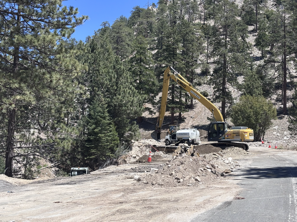
Crews have and will continue installing K-rail barriers around washed-out shoulders and road; repairing eroded slopes and embankments under the road; reconstructing shoulders and slopes to their “original design grades,” which is a feat of engineering I’m personally impressed by; and installing erosion control measures to better ensure a future storm does not cause the exact same issues that prompted previous repairs, according to a Caltrans fact sheet of the project.
Caltrans spokesperson Eric Menjivar said in an email Tuesday that at least some of the repairs are on hold as the agency obtains supplemental funding through an internal review process to finish the repairs.
Contractors have continued work to prep the roadway for El Niño, he said, including slope erosion control work.

An excavator works to repair a segment of Angeles Crest Highway.
(Jaclyn Cosgrove / Los Angeles Times)
In terms of the timing of when we will start to see rainfall, it could be as early as this month.
“Forecasters say there’s a 75% chance this latest El Niño — a climate pattern characterized by warmer ocean waters in the central and eastern tropical Pacific — will be stronger than any other since 1950,” Times staff writer Iris Kwok wrote. “There is a 98% chance that El Niño will be ‘very strong’ for the three-month period ending in December, according to the National Oceanic and Atmospheric Administration’s Climate Prediction Center.”
That’s why I wanted to dig into which trails would be most affected by a California 2 closure. Below, I’ve listed trails that are primarily accessed using a trailhead off the route, while also noting how hikers might still reach a peak or vantage point using another option.
I am not suggesting where damage will or won’t occur, but rather encouraging you to get out on these trails soon — especially if they’ve been on your list for a while — while it remains easy enough to drive to their trailheads. Additionally, we cannot predict how our trails will fare during a significant El Niño winter.

A sweeping view of Angeles Crest Highway and the San Gabriel Mountains from the Hoyt Mountain trail.
(Jaclyn Cosgrove / Los Angeles Times)
Here are trails primarily accessed off California 2:

The Gabrielino Trail is a multiuse trail frequented by hikers, bikers and horseback riders.
(Jaclyn Cosgrove / Los Angeles Times)
- Grizzly Flat Trail: A challenging 7.4-mile out-and-back route where you climb up and then down the mountainside, reaching the Stonyvale picnic area where you can have a lunch break before clambering back up the mountain.
- Hoyt Mountain via Grizzly Flat: A 4.6-mile steep jaunt up to Hoyt Mountain, a 4,415(ish)-foot peak in the front range of the San Gabriel Mountains in Angeles National Forest. There are multiple routes to reach it (see map), which you can read about in a previous Wild.
- Switzer Falls and picnic area: The 4.6-mile Switzer Falls hike, one of the most popular in the forest, is primarily reached via the Switzer picnic area off California 2; note that my distance includes walking down from the parking area adjacent to the road, as the gate has been closed recently because of bear activity; if that trailhead became inaccessible, Switzer Falls could be reached off the Gabrielino Trail, but it’s a much longer hike (about 20 miles one way from Azusa, or about 8.8 miles one way from near Pasadena).

One cascade of Switzer Falls.
(Brian van der Brug / Los Angeles Times)
- Colby Canyon Trail: This difficult 9.2-mile out-and-back trail takes hikers to Strawberry Meadow, a flat area in the San Gabriels with nice views. Note: Do not attempt to use the mountaineering route to reach Strawberry Peak. There is an option, as noted on the map, to also hike to Josephine Peak during the same excursion.
- Strawberry Peak Trail: This 7-mile out-and-back route takes hikers to the highest peak in the front range of Angeles National Forest. Said to resemble an upside-down strawberry, the summit is reached through a moderately strenuous hike that offers great views of the surrounding mountains. The route is exposed and should not be attempted on warm weather days.
- Mt. Wilson area: If California 2 shuts down before Mt. Wilson Red Box Road, which leads to the Mt. Wilson Observatory, several trails will be either inaccessible or much more challenging to reach. That includes reaching Mt. Disappointment, Mt. Deception or Mt. Markham. Hikers would technically be able to access those peaks by first summiting Mt. Wilson, but that requires a 7-mile journey up Little Santa Anita Canyon where you gain about 4,800 feet. There’s a limited number of people who want to hike more after that.
- Redbox to Valley Forge: A beautiful 4.8-mile out-and-back trek to Valley Forge Trail Camp via the Gabrielino Trail, where hikers can go farther in multiple directions should they choose.

The Vetter Mountain lookout tower in Angeles National Forest.
(Jaclyn Cosgrove / Los Angeles Times)
- Vetter Mountain Lookout: A 5(ish)-mile round trip that includes a stop at a fire lookout where you will get sweeping views of the surrounding peaks and valleys.
- Devils Canyon Trail: A 5.8-mile out-and-back stretch down 1,400 feet into a shaded canyon where a seasonal stream runs.
- Mt. Hillyer from Chilao via Silver Moccasin Trail: A 6(ish)-mile journey in a corner of the San Gabriel Mountains that has both high desert vibes and pine trees — and boulders! (One of my favorites.)
- Three Points to Sulphur Springs: This is a 7.4-mile out-and-back hike along the Pacific Crest Trail where you reach Sulphur Springs Trail Camp. The camp sits at 5,300 feet and features about six tent-camping sites. Its campsites are shaded by tall pine trees, ideal for hanging a hammock. It has vault toilets but no potable water or bear boxes.
- And more!
There are obviously others, including some I’m not listing because I know they’re not in great condition. Additionally, several hikes remain accessible under the current closures only by hiking or biking to them. That includes the Burkhart Trail, Cloudburst Summit to Cooper Canyon Trail Camp, Throop Peak, and, as mentioned, the Mt. Waterman Trail.
I found a few hikes I’ve never done thanks to this week’s Wild. I hope it serves a similar purpose for you. Let me know if you get out there and where you go! If you received this newsletter as an email, you can simply reply, and your messages come right to me. See you out there!

3 things to do

Skaters meander through Little Tokyo during a previous CicLAvia event.
(CicLAvia Los Angeles)
1. Dilly-dally through downtown L.A.
CicLAvia will host a 6.5-mile open streets event from 9 a.m. to 4 p.m. Sunday via a route that connects Echo Park, downtown L.A., Chinatown, Little Tokyo, the Arts District and Boyle Heights. Guests are welcome to walk, bike or use other people-powered mobility devices to traverse the route. See rules for e-bikes. Learn more at ciclavia.org.
2. Craft local clay in L.A.
Clay artist Evelyn Hernández will host from 10 a.m. to 1 p.m. Sunday a hike through Griffith Park and teach participants along the way to identify clay and earthen pigments in their natural habitat. Attendees will also create a ceramic piece using locally processed clay. Tickets are $48.05 to $63.63 based on your economic ability to pay. Register at events.humanitix.com.
3. Haunt the hillsides near Atwater Village
Dance Quest will host a Halloween-themed silent disco from 9:30 to 10:30 a.m. Saturday through Griffith Park. Attendees will dance along a 1.5-mile loop trail while wearing headphones with a curated playlist. Halloween costumes and flair welcomed and encouraged. Suggested donation of $15 to $25. Register at eventbrite.com.

The must-read

George Jensen records audio of geese and ducks during a Los Angeles Field Recording meetup at the Sepulveda Basin Wildlife Reserve.
(Kayla Bartkowski / Los Angeles Times)
One of the best parts of hiking is the unexpected sounds that nature provides, from the crunch of your boots on the sandy soil to the surprisingly thunderous sounds a covey of quail makes as it leaves a shrub (which has maybe scared a certain outdoors journalist more than once). And because L.A. has a club for truly everyone, there’s now a place nature sound lovers can go to really appreciate what they find outdoors, the Los Angeles Field Recording Club. “I feel like now everything’s so … doctored. But when you’re recording, this is what’s really happening. You’re hearing real sound. You’re engaged with the world in a real way,” said George Jensen, founder of the Los Angeles Field Recording Club.
Happy adventuring,

P.S.
Everyone is looking for a way to escape this heat wave, including the black bears of the San Gabriel Mountains. Wildlife photographer Robert Martinez shared a video this week of one of our ursine neighbors taking a dip into cool water deep in Angeles National Forest. The bear even takes time to exfoliate, using what appears to be a concrete barrier to scratch its back. Now that’s self-care!
For more insider tips on Southern California’s beaches, trails and parks, check out past editions of The Wild. And to view this newsletter in your browser, click here.