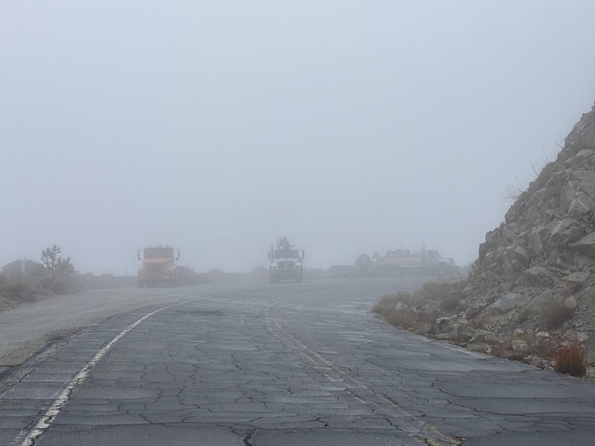
I was so focused on looking ahead to make sure a mountain lion or bear wasn’t emerging from the fog that I didn’t notice the semitruck headed straight for me.
I simultaneously gasped and panicked.
Then my brain caught up with my body. I remembered I was hiking on a closed highway. And I was staring at, thankfully, stationary construction equipment. My heart rate slowed, and then I wondered aloud: “What’s this doing here?”

Construction equipment sits on a turnout on Highway 39 on a closed segment. Caltrans is, yet again, tending to emergency repairs the highway requires after serious storms last winter.
(Jaclyn Cosgrove / Los Angeles Times)
Last week, I hiked on a foggy, misty day along a 4.4-mile stretch of Highway 39 that’s been closed for almost 50 years, after massive landslides left the road impassable (and too expensive and dangerous to fix). It’s since been a popular hiking and biking route, offering a quiet escape and easy connection to the larger Angeles National Forest. But how long can this road survive the elements, especially with El Niño increasing the odds of substantial storms this winter?
In this week’s edition of The Wild, our weekly outdoors newsletter, I will try to answer that question, which per a recent Reddit discussion, is weighing on local hikers. I can say that, after reporting this out, I actually feel some hope about Highway 39’s future.
On Friday, I began my hike at the start of the highway’s current closure, which lengthens the journey from 4.4 miles to about 6 miles. I parked in a large lot just past the Crystal Lake turnoff.

The gate that leads to the 4.4-mile segment of Highway 39 that has been closed almost 50 years.
(Jaclyn Cosgrove / Los Angeles Times)
The stretch of Highway 39 that runs from Crystal Lake to Islip Saddle was constructed by inmates from San Quentin and other prisons, opening to traffic on Nov. 6, 1961, according to Times archives. This was part of a long history of California using prison labor — or commonly referred to as “involuntary servitude” by civil rights groups — to construct its roadways. The state is said to have granted workers credits toward reducing their sentences based on the number of days they worked.
The road was quickly at odds with Mother Nature.
Rain during an El Niño winter caused a major landslide in January to February of 1969 near Snow Spring and then again, in February and March of 1978, according to a Caltrans analysis and Times archives.
The roadway has been closed since and remains one of the Caltrans L.A. office’s biggest headaches, as massive boulders frequently tumble down from the jagged mountain side, and landslides remain common. Caltrans, meanwhile, remains bound by state law to maintain the roadway to some degree.

Heaps of scree and dirt line much of the shoulder along the closed segment of Highway 39.
(Jaclyn Cosgrove / Los Angeles Times)
After my mosey down the closed road, I can easily see why the road is such a headache to repair. A massive boulder blocked most of the right lane (the lane that drivers would take to travel from Azusa to Islip Saddle). Several hillsides had collapsed, sending heaps of scree onto the shoulder or roadway.
One of the biggest challenges, though, for Caltrans is 2.3 miles from the first gate where storms have almost washed out the entire road. The large hole, covered in a thick white material that appears to be plastic, has a steep drop-off into the valley below, resembling someone trying to build an infinity pool in the middle of the forest.
I was surprised to find an active construction project underway.
Highway 39 is often said by influencers and bloggers to be an “abandoned” highway, and although that’s inaccurate, Caltrans has actually tried to relinquish its responsibility of this troubled road. In 2012, the agency asked if either the U.S. Forest Service or Los Angeles County officials would take the reins. Both agencies essentially said, “No thanks!” with the U.S. Forest Service adding that its interpretation of the contract between the state and federal agencies was that Caltrans would actually have to remove the roadway and “return the area to the natural landscape,” according to Times archives.

A large hole where storms destroyed a segment of Highway 39.
(Jaclyn Cosgrove / Los Angeles Times)
All that‘s to say: Caltrans remains stuck with this road for the foreseeable future and thus has to keep working on it.
Caltrans spokesman Marc Bischoff said in an email that multiple severe winter storms between December 2025 and January 2026 produced higher-than-normal rainfall “that resulted in concentrated runoff down a slope at post mile 40.8 that eroded the slope, berm, and shoulder, and undermined and collapsed the roadway.”
“This section of highway must be repaired as soon as possible to provide access to emergency service response and maintenance vehicles,” Bischoff said. “Work includes excavation and removal of failed roadway and unstable slope material; disposal of material; reconstruction of the embankment; reconstruction of the roadway and shoulder with hot mix asphalt; and placement of erosion control mesh, turf reinforcing mat, fiber rolls, and hydroseeding to stabilize the disturbed slopes and reduce future erosion.”

Tall rock piles line the roadway that’s been closed to vehicles for almost 50 years.
(Jaclyn Cosgrove / Los Angeles Times)
But Caltrans has plans beyond emergency repairs.
For several years, Caltrans has studied how it should address the future of Highway 39. After weighing several options (including doing nothing) with other state and federal agencies, the agency will move forward with a plan (called Alternative 2) to reopen State Route 39 as an evacuation route for emergency service responders and maintenance crews only. Caltrans will continue to allow hikers and bikers “informal” access to the roadway, according to its January 2025 environmental impact report.
This project is in its design phase. Construction is expected to begin in winter 2032, Bischoff said.
Some of the challenges that Caltrans will face include that, “the highway ascends from an elevation of 5,560 feet above mean sea level (AMSL) at the southern end to 6,670 feet AMSL at the northern end where it intersects with SR-2. The project area is located in the San Gabriel Mountains, within the Transverse Ranges geomorphic province, which is characterized by a complex series of mountain ranges and valleys with dominant east–west trends. Most of the roadway alignment and immediate area is predominantly underlain by slightly to moderately weathered and moderately to intensely fractured igneous intrusive bedrock … Due to the geologic conditions, significant rockfall events have occurred at numerous locations throughout the project area,” according to its environmental impact report.

A view of an open stretch of Highway 39 that leads to Crystal Lake Recreation Area, which includes a large campground and cafe.
(Jaclyn Cosgrove / Los Angeles Times)
During construction, Caltrans might restrict access, though, when it is unsafe for hikers and bikers to pass through. I didn’t see any construction workers or signage barring access when I went. Please follow posted signage, as it’s generally there for your safety.
This closed stretch is even more important to hikers after a massive storm pummeled Angeles Crest Highway, leading Caltrans to close the roadway just past Three Points. (If you’re wondering about what El Niño could potentially do to Highway 2, check out my recent article.)

Clouds dissipate in the late afternoon above an open stretch of Highway 39 north of Azusa.
(Jaclyn Cosgrove / Los Angeles Times)
With the Angeles Crest Highway closure, hikers could take Highway 39 about six miles to Islip Saddle, rather than the 10-mile journey required by parking at the Angeles Crest Highway closure and walking that stretch of closed road.
Caltrans has tried for years to address Highway 39’s long-term future. The agency projects its current plan will cost an estimated $46 million.
Meanwhile, the agency remains bound by California Streets and Highway Code to maintain the highway. If El Niño brings storms that damage the road again, history suggests Caltrans will fix it, seemingly stuck in an endless loop of patchwork repairs for one of California’s most challenging mountain highways to maintain. That’s a strange silver lining to a bureaucratic nightmare.

3 things to do

A Cabrillo Marine Aquarium staffer teaches children about life in a tide pool.
(Cabrillo Marine Aquarium)
1. Search for cephalopods in San Pedro
Educators from the Cabrillo Marine Aquarium will host tide-pool walks on Saturday (12:30 to 2 p.m.) and Sunday (1:30 to 3 p.m.) at the Point Fermin tide pools in San Pedro. Guests can attend a brief orientation and then head on a naturalist-led hike to see the animals in their natural habitats. Outdoor clothing and closed-toed sneakers are recommended. Learn more about the Saturday and Sunday hikes at cma.recreation.parks.lacity.gov.
2. Assist the land’s recovery near Altadena
We Explore Earth, a community-building outdoors nonprofit, is organizing a volunteer group to repair habitat from 8 to 11:30 a.m. Friday at Eaton Canyon Nature Area. Volunteers should wear close-toed shoes, long pants, work gloves and other protective gear, along with their own water and snacks. Park staff will provide hand tools. Sign up at signupgenius.com.
3. Seek out snowy egrets in Santa Paula
The Ventura County Resource Conservation District will host a free 3-mile walk from 8:30 to 10:30 a.m. Saturday through the Santa Clara River Preserve (1368 Mission Rock Road in Santa Paula). A bilingual biologist will answer questions as guests meander the habitat, looking out for local bird species. Register at eventbrite.com.

The must-read

Times staff writer Deborah Vankin, left, participates in a 50-minute walking therapy session with therapist Ismary Colón Angueira on the Fern Dell Trail in Griffith Park.
(Genaro Molina / Los Angeles Times)
I often tell my wife as I return home that a hike felt “therapeutic,” but I mean it more in a holistic sense. I leave the trail often in an improved mood with more clarity — sometimes after talking through a problem with myself as the trees listen. But I hadn’t thought about meeting my therapist on the trail. Times staff writer Deborah Vankin recently explored the practice of walking therapy by taking a hike through Griffith Park with psychotherapist Ismary Colón Angueira, who specializes in the modality. “Bringing people back into relationship with nature,” Colón Angueira said, “is the bigger point of all this. In my ideal world, my clients continue walking after they stop seeing me. And they reconnect to this relationship with place. Being in nature is our birthright. It’s something that everybody has access to. And it’s healing.”
Happy adventuring,

P.S.
The Trans-Catalina Trail is a 38.5-mile journey across Santa Catalina Island, taking hikers through rugged landscape with incredible views of the island’s mountains, pristine coast and the Pacific Ocean. Planning a multi-day backpacking trip there is no easy feat, as visitors must pack for significant elevation gain and loss — more than 6,000 feet total, according to the Catalina Island Conservancy — on a route with minimal shade. Sports and outdoors store Sports Basement will host a free seminar about how to prepare for hiking the Trans Catalina Trail at 6:30 p.m. Wednesday at its Long Beach location. Regardless of how long this trek has been on your adventure bucket list, this sounds like a great opportunity to learn more.
For more insider tips on Southern California’s beaches, trails and parks, check out past editions of The Wild. And to view this newsletter in your browser, click here.