For scientists, measuring the water in a river or a lake is relatively straightforward. It’s much more complicated to figure out how much water lies underground.
After years of research, a team of scientists has finally mapped what remains of these hidden waters across the United States, and they’ve produced the most extensive estimate of the country’s groundwater to date.
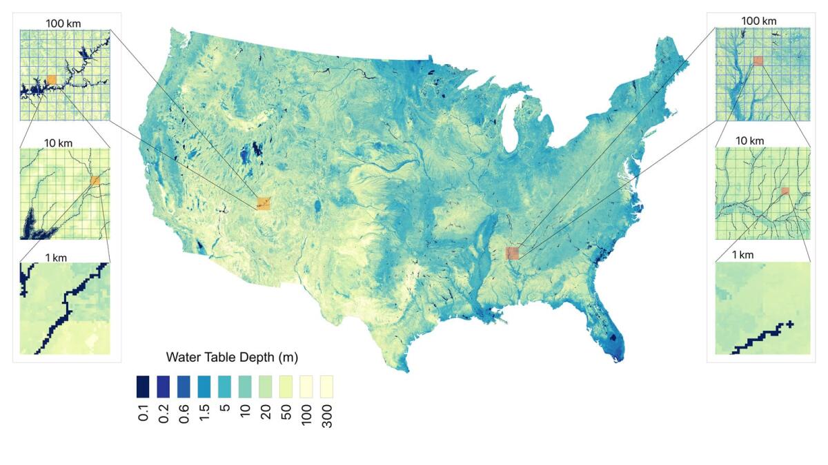
Researchers at Princeton University and the University of Arizona took data from about 800,000 wells and applied a machine-learning model to estimate the depth of the water table nationwide.
“Groundwater is out of sight and out of mind for most people,” said Reed Maxwell, a hydrologist at Princeton and co-author of the recent study in the journal Nature. “Knowing how much we have will be helpful in knowing how to use it wisely.”
They incorporated data on the geology of aquifers and estimated down to nearly 1,300 feet, far deeper than most wells.
The scientists say their detailed map and data could help local decision-makers address overpumping from stressed aquifers, and help researchers estimate how much water has been depleted.
California has seriously depleted groundwater in the San Joaquin, Salinas and Cuyama valleys, Ventura County and other places, with some of the fastest rates of water decline in the world.
In parts of the Central Valley, where large farms draw heavily from wells, aquifer levels have plummeted. The U.S. Geological Survey estimates it has lost 128 million acre-feet, comparable to the volume of Lake Tahoe, since pumps started pulling it out in the early 20th century.
That was as of 2019, and water levels have continued to decline.

(Yueling Ma et al. / Princeton University)
In the desert Southwest, the groundwater is largely considered “fossil water” because it took millennia to accumulate. So once it is pumped out, it’s in effect gone for good.
Even depleting small amounts of water can be a problem, said co-author Laura Condon, a University of Arizona hydrologist. “We see this in Arizona and in Southern California too, where long before you run out of water, you start disappearing wetlands, disappearing small tributaries.”
The total quantity of water underground is still immense. The scientists found nationwide there is roughly 250 billion acre-feet, or 13 times the volume of the Great Lakes.
Data compiled by lead author Yueling Ma show the Colorado River watershed has about as much groundwater as the volume of the Great Lakes, while California has about 70% of that.
Those are vast quantities, but the researchers said that definitely doesn’t mean there is plenty of water to recklessly use up. Declines in groundwater levels have in recent years caused household wells to sputter and run dry, streams and wetlands to dry up, and land to sink, damaging canals and levees. California’s database of dry wells shows about 6,000 have run dry since 2013, but in the last year, only 13 dry wells were reported. So that problem has slowed down for now. It could soon worsen again.
The new map shows groundwater varies widely across the country. In some places, you have to drill down 300 feet to reach it. In others, it’s just a few feet below the soil.
The map can help scientists studying where slow-flowing aquifers are feeding nature, nourishing streams and wetlands.
Jay Famiglietti, a hydrologist and professor at Arizona State University who wasn’t involved in the research, called the researchers’ map and estimates a “remarkable achievement for modeling and understanding groundwater” in the United States.
The scientists “convincingly show that it is now possible to simulate groundwater depths and availability at very high resolutions,” he said, and they have made their results “accessible and useful for water managers across the country.”
He said the research adds to satellite measurements that scientists now use to track shifts in water over time. What the country still needs, he said, is a “national-scale network of deep groundwater wells” to track the quantity and quality of water all the way down to bedrock.
More water news
Two years ago, Gov. Gavin Newsom announced a strategy to save declining salmon. Now, as Rachel Becker reports for CalMatters, members of the Winnemem Wintu Tribe say the state is ending its support for an effort to reintroduce endangered winter-run Chinook to waters upstream of Shasta Lake reservoir, and they feel betrayed.
The Trump administration recently announced it will spend $40 million to begin a plan to raise the height of Shasta Dam, which would expand California’s largest reservoir. As Camille von Kaenel reported for E&E News by Politico, dozens of environmental, fishing and tribal groups sent a letter to Newsom urging him to oppose the Trump administration’s renewed effort to raise the dam.
I followed up to ask Newsom’s office about the idea of raising Shasta Dam. “We aren’t getting distracted by conceptual projects, years from viability,” Newsom spokesperson Tara Gallegos said. Instead, she said the governor is focusing on getting the planned Sites Reservoir built northwest of Sacramento, which “will benefit regions throughout California and is much farther along towards construction.” Gallegos added that the state already is “a significant investor in the project, and the federal government should join us in ensuring this project comes to fruition.”
In the San Joaquin Valley, the Delta-Mendota subbasin has become the fourth farming area to avoid being placed on groundwater probation by state regulators. The State Water Resources Control Board voted this week not to impose enforcement measures on the area, Monserrat Solis reported for SJV Water.
More climate and environment news
The Trump administration has a budget proposal that calls for increasing military spending while slashing funding for clean energy and federal science programs. My colleague Hayley Smith wrote about the proposed cuts, which are strongly opposed by Democrats and environmental groups.
A wolf that captured national attention when she ventured into L.A. County earlier this year continues to make history. As Lila Seidman reports for The Times, it’s the first time a wolf has ventured into Inyo County in the Eastern Sierra in more than a century.
Imperial County supervisors voted to combine several parcels of land to clear the way for construction of a massive data center, which has faced opposition from residents who worry about the complex’s environmental footprint, Kori Suzuki reports for KPBS.
California’s last remaining nuclear power plant has received federal approval to run through at least 2030. My L.A. Times colleague Blanca Begert reports that the federal Nuclear Regulatory Commission has renewed Diablo Canyon Power Plant’s license to operate.
A couple more things
Los Angeles Climate Week started April 8, with a big lineup of community events running through April 15. Here is the full calendar of events, which include a day of activities along the L.A. River and an interfaith climate gathering.
PBS SoCal’s new season of its locally produced environmental series Earth Focus premieres April 22, Earth Day, at 7:30 p.m., with an episode focusing on how L.A. stadiums are taking steps to be more environmentally friendly.
This is the latest edition of Boiling Point, a newsletter about climate change and the environment in the American West. Sign up here to get it in your inbox. And listen to our Boiling Point podcast here.
For more water and climate news, follow Ian James @ianjames.bsky.social on Bluesky and @ByIanJames on X.