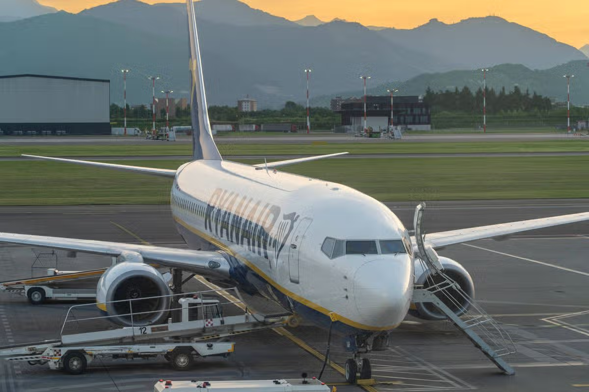
Ryanair has consistently railed against Nats(Image: Mrkit99 via Getty Images)
Budget carrier Ryanair has issued an update, confirming that it cancelled 1,000 flights.
It partly attributed the recent “collapse” of Britain’s air traffic control system for the scrapping more than 1,000 flights in September. The Irish airline said the cancellations stemmed from two separate air traffic control (ATC) failures within a fortnight of one another last month, alongside ATC strikes in Belgium and widespread disruption across Europe caused by volcanic ash clouds from eruptions at Mount Etna.
The head of Britain’s National Air Traffic Services (Nats), Martin Rolfe, has faced mounting calls to quit following a string of air traffic failures that led to thousands of flight cancellations across the industry last month, leaving hundreds of thousands of passengers stranded.
The most recent incident was triggered by a “connectivity issue” at its Prestwick centre in Scotland, which was unrelated to an ATC software fault on September 8 that sparked widespread travel chaos.
Ryanair has been among those demanding Mr Rolfe’s resignation, while Transport Secretary Heidi Alexander has arranged a meeting with Nats chairman Sir Warren East, the former chief executive of Rolls-Royce, in the coming weeks to address the ongoing issues.
Latest Ryanair figures
Ryanair’s most recent traffic statistics revealed the airline operated over 111,700 flights last month, carrying 20.1 million passengers, a rise of 4% year on year. Wizz Air also released passenger data showing a 24% increase year on year in passengers flown last month, reaching 7.78 million, with capacity up 25.3%.
Yet Wizz announced recently it would slash its flight schedule by 5% over the second half of 2026 owing to broader Iran war pressures on the travel sector and spiralling fuel costs.
Following the latest disruption, easyJet said it “calls into question the resilience of Nats’ systems” and Jet2 said customers and airlines need “action, accountability and proper resilience”.
Calls to resign
On September 21, chief operations officer for Ryanair Neal McMahon said: “Martin Rolfe has presided over repeated system failures, repeated passenger disruption and repeated failures to deliver an effective back-up system.
“Enough is enough. Martin Rolfe should resign today.”
Tim Alderslade, chief executive of industry body Airlines UK, said ATC was “critical national infrastructure” which “must be resilient enough to keep people moving”.
He added: “Yet another Nats failure is causing delays and disruption for passengers and airlines alike, and comes just days after its report into the most recent major outage. Passengers and airlines deserve better and the independent CAA (Civil Aviation Authority) report, together with the forthcoming Civil Aviation Bill, must address the underlying weaknesses in the system so that these failures stop happening.”
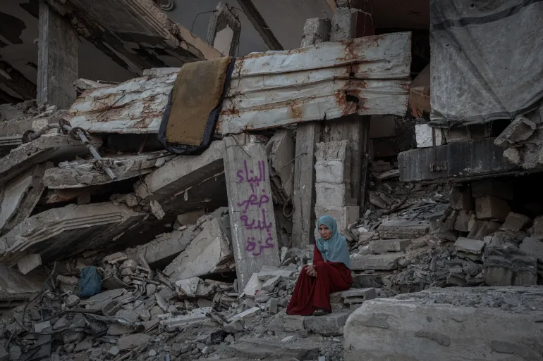
Gaza City, Gaza Strip – The partially collapsed roof above Masada Abu Jarad’s apartment is now made up of broken concrete with twisted steel bars protruding from its edges.
And underneath the section of the room that is now open to the elements after the building’s partial collapse, Masada’s family have pitched a tent to provide shelter.
Recommended Stories
list of 3 itemsend of list
The 60-year-old knows the structure is dangerous. The Palestinian Red Crescent and the Civil Defence visited the family last week and warned them that they should leave. But in Gaza, where Israel refuses to allow proper reconstruction to take place after almost three years of its genocidal war, there are few places for them to go.
“We have no options,” Masada says. “I want to leave, but who will give me an alternative?”
She has lived in the building in Gaza City’s Palestine Square area for the past year, after returning to northern Gaza from displacement earlier in the war. But this still isn’t home. Masada’s family is originally from Beit Lahiya in the far north of the Strip, but had to leave early in the war after Israel decimated the area. They are still unable to return.
After repeated displacement, the prospect of moving again without a safe destination has become exhausting. And even if they could move, the cost is prohibitive.
“Even if there is a better place, tell me how I can afford to rent it,” Masada said.
Masada’s experience reflects a wider housing crisis across Gaza for the Palestinians who have survived Israel’s war, which has killed more than 73,000 Palestinians.
A joint assessment by the United Nations, World Bank, and European Union found that 371,888 housing units, 76.6 percent of the housing stock, had been destroyed or damaged as of October 2025. The assessment also found that rebuilding Gaza will need more than $71bn over the next decade.
The dangers of Gaza’s depleted and damaged housing stock became starkly visible on September 16, when a six-storey war-damaged residential building in Gaza City collapsed, killing 21 people, including 12 children, according to the UN and Gaza Civil Defence.
The collapse has become a warning for families living in other damaged structures.
Gaza’s municipality and civil defence have warned residents to evacuate buildings at risk of collapse [Abdelhakim Abu Riash/Al Jazeera]
‘I stay awake so they can sleep’
Abdullah Abu Hajar, 40, lives with his wife and five children in the al-Najma building in Gaza City’s southern Remal neighbourhood.
The six-storey building is severely damaged and unstable. About 17 families, roughly 50 to 60 people, are living there, according to Abdullah.
On the outside walls, municipal notices warn residents and passers-by that the building is unsafe and at risk of collapse.
At night, while his wife and children try to sleep, Abdullah stays awake and listens.
Every unfamiliar sound, such as concrete shifting, stones moving or an unexplained creaking somewhere inside the building, puts him on alert.
“I stay awake all night, keeping watch,” he said. “I can’t close my eyes. I keep just listening to sounds around me.”
Abdullah Abu Hajar stands near the damaged building where he lives with his family [Abdelhakim Abu Riash/Al Jazeera]
Abdullah explained that he feels worried for his children, even though they have adapted to the danger. But he has not.
And after the September 16 building collapse, he grew even more fearful. Since then, he said, he has barely slept.
“I’m already on edge,” he said. “But I don’t know where I can go.”
Abdullah and his family were displaced from Beit Hanoon in northern Gaza after it was attacked by Israel, and moved repeatedly during the war, eventually finding the al-Najma building.
His extended family faces the same uncertainty. Abdullah said that one of his relatives has been moving between southern and northern Gaza, looking for a place where he can pitch a tent.
“I told him to come and stay with us,” Abdullah said. “But he is hesitant because of the condition of this building. At the same time, he has nowhere else to go.”
Islam Hassanein is particularly worried about how weather conditions in the winter will affect the partially collapsed building she lives in [Abdelhakim Abu Riash/Al Jazeera]
A room among the rubble
For Islam Hassanein, 36, the same fears are entwined with the place she calls home.
A mother of five, Islam has spent nearly a year living with her family in a single room on the third floor of a damaged building.
She found the room after searching for somewhere to stay. It was filled with rubble and debris.
“We cleaned it and stayed in it,” she said.
The building is leaning and visibly damaged. The plumbing doesn’t work, so the family uses a bathroom outside. There is little that resembles a family home.
But leaving has proved no easier than staying. “We keep looking, but we can’t find anywhere,” she says. “They might even force us out of here. What are we supposed to do?”
Islam says she would leave immediately if she were offered a safe place.
“If they find us a good place and provide us with a tent, we will leave from the morning,” she says. “But where is this place? And where is the tent?”
Islam’s daughters sit inside the room where they live in the al-Najma building, which is at risk of collapse. [Abdelhakim Abu Riash/Al Jazeera]
The building itself regularly reminds her of the dangers.
“Every day, you hear the cracking,” she says. “People who live here tell us, ‘It’s cracking.’ Then a column fell, and they took us out of the building temporarily.”
The potentially deadly risks will become harder to manage as winter approaches, with its colder and wetter weather.
Water can enter through exposed roofs and walls, and the already weakened structure will face additional pressure from heavy rain.
“Last winter was terrifying,” Islam said. “We were constantly afraid that the building would collapse. I spent most days in my family’s tent because this building was full of openings and would flood whenever it rained.”
“Now, I am very afraid of this winter, and I don’t know what we are going to do.”
The UN says thousands of people are sheltering in damaged buildings considered unsafe because better housing options are unavailable.
Israeli restrictions on the entry of tents, tarpaulins and other essential shelter materials are making the situation more difficult, leaving Gaza in a state of limbo, unable to move on from the war, particularly as Israel can choose to escalate the conflict at any time.
UNICEF estimates that nearly 84 percent of Gaza’s population, more than 1.76 million people, are living in overcrowded displacement sites or damaged and inadequate shelters, with little protection from cold, heavy rain and flooding.
Islam says the war has forced families to take risks they once would have considered unthinkable.
She worries about her five children, but sees few choices available to her.
“They are all afraid,” she said. “But what can we do? If there is an alternative, I will leave. We leave it to God.”
The damaged al-Najma building is among the structures at risk of collapse in Gaza [Abdelhakim Abu Riash/Al Jazeera]
A gold mine collapse in northern Sudan has killed at least 10 people and injured 21, according to survivors, bringing renewed attention to the dangers facing workers in one of the country’s most important and least regulated industries.
The collapse took place on Sunday at the Awny mining area near Sudan’s border with Egypt. Miners told the AFP news agency they had recovered 10 bodies and pulled 21 injured workers from the site, while the search continued for people believed to be trapped beneath the rubble. It is unclear how many people are trapped in the collapsed mine.
The disaster comes just days after another deadly accident at a gold mine in West Kordofan State. A collapse at the al-Zaraa mine near en-Nahud, a town in central Sudan, left at least 82 people dead.
Sudan is one of Africa’s top gold producers, recording 70 tonnes of production last year, according to the Sudanese government.
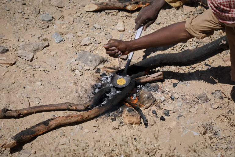
Miners heat processed gold concentrate over an open fire at an artisanal mining site in Dalago Mahas, Sudan’s Northern State, Friday, May 8, 2026 [Mohaned Bilal/AP Photo]
Since fighting broke out in April 2023 between Sudan’s army and the paramilitary Rapid Support Forces (RSF), businesses have been devastated, agriculture has been disrupted, millions of people have been displaced, and Sudan’s formal economy has weakened. In that environment, gold has remained one of the country’s most valuable sources of income.
In July 2025, it was reported by local agencies that Sudan’s gold production rose sharply despite the ongoing conflict, reaching 64 tonnes in 2024, 53 percent higher than the 41.8 tonnes recorded in 2022, and generating $1.57bn in legal export revenues.
However, the gold trade has also become a point of international scrutiny. Most of the gold exports end up in the UAE. In March 2025, Sudan went to the International Court of Justice (ICJ), accusing the UAE of supporting and funding the RSF using gold. The UAE has denied accusations that it supplies weapons to the RSF.
Sudan’s gold deposits are spread across the country, with the majority in the northeast. Port Sudan, the country’s main port, is home to most of the deposits and has been largely controlled by the Sudanese Army since the war began. However, areas controlled by the RSF are also populated by gold deposits.
At the moment, “much of Sudan’s gold is taken out of the country through smuggling or illicit networks instead of passing through government channels that could directly contribute to public revenue,” said Joseph Tucker, senior analyst on the Horn of Africa at the International Crisis Group.
But amid that diplomatic battle and the accusations surrounding gold, the mining deaths in northern Sudan have also raised larger questions over how the country manages the sector, analysts say.
“This disaster is yet another example of the deadly hazards facing those working in Sudan’s gold mines,” Tucker told Al Jazeera. “Most of these (gold mines) are informal, artisanal mines in remote areas that are unregulated and lack modern mining technology, adequate infrastructure, and specialised safety equipment.”
This year, Sudanese Prime Minister Kamil Idris met with the minister of minerals and spoke on the policies for regulating traditional mining and the management and control of various mineral markets. According to French-based Sudanese media, Sudanese authorities called for swift action to address the environmental damage and public health hazards caused by mining activities across the country.
Yet, despite the dangers, Tucker said the state of the Sudanese economy made gold mining appear lucrative to many Sudanese.
During the war, the Sudanese currency’s value has crashed. Before the outbreak of fighting in 2023, about 570 Sudanese pounds could buy a US dollar. By April 2026, the currency had slid to a sixth of that value: It cost 3,500 pounds or more to afford a dollar. That has led to sharp food inflation and a surge in the costs of transport and fuel.
According to estimates by the United Nations Development Programme, Sudan lost $6.4bn of its gross domestic product (GDP) in 2023 alone: That’s a quarter of the country’s $26bn GDP that year. In August, the UN agency reported that 90 percent of the agrarian nation’s farmers had seen yields drop over the previous year.
That economic crisis, Tucker said, “fuels the demand for gold and willingness of miners to work in poor conditions” – even if it proves deadly.
New Delhi, India – On the morning of August 26, the Himalayan landscape above Nepal’s Rasuwa district changed in minutes.
A mass of ice and rock broke loose high in the mountains and sent a violent surge of water, mud and debris down the Lhende Khola River. The torrent travelled through valleys, swept away settlements and infrastructure and eventually reached the Nepal-China border.
What followed was not simply a flood.
It was a chain reaction.
By mid-September, more than 1,400 people had been reported dead and at least 6,000 remained missing in Nepal and across the border in Tibet. Twelve hydropower plants were destroyed, while roads, bridges and homes were buried or washed away.
The scale of the destruction has left scientists and disaster managers confronting a difficult question: How do you warn communities about a disaster whose trigger may occur high above them, in terrain that is difficult to monitor and where there may be only minutes to react?
Basanta Raj Adhikari, director of the Centre for Disaster Studies at Tribhuvan University in Kathmandu, described the event to Al Jazeera as unprecedented in size, affected area and mechanism. His estimate suggested that the energy involved was greater than that released by the Hiroshima atomic bomb, a comparison intended to illustrate the scale of the physical forces involved rather than suggest that the event was equivalent to a nuclear explosion.
For scientists who study the Himalayas, the disaster demonstrated how quickly an event originating in a remote, high-altitude environment can become a regional catastrophe.
And Nepal is not alone.
The warning problem
A warming climate is altering glaciers, snow cover, permafrost and high-altitude lakes. At the same time, roads, hydropower projects, tourist facilities and settlements have pushed deeper into mountain valleys.
That combination is creating a new risk landscape in which one hazard can trigger another.
An avalanche can block a river. A blocked river can form a temporary lake. A sudden release can become a debris flow. That debris can destroy a road or bridge, block another river and create another flood downstream.
The August disaster in Nepal showed how quickly such a sequence can unfold. It also exposed a weakness in the way early-warning systems are often designed.
Many systems are built around a particular hazard: rainfall, river level or glacial lake outburst flood. But the Himalayas do not always respect those categories.
In July, the International Centre for Integrated Mountain Development, or ICIMOD, warned that a below-normal monsoon should not be interpreted as a safer one.
“The biggest misunderstanding is that less seasonal rainfall means lower flood risk,” said Saswata Sanyal, a disaster risk reduction specialist at ICIMOD.
“A drier monsoon can still be a dangerous monsoon,” he added, warning that seasonal averages cannot capture the cloudbursts capable of producing catastrophic flooding in mountain valleys.
The Nepal disaster went a step further.
The immediate trigger was not simply heavy rainfall.
Scientists have been examining an ice-rock avalanche and other possible processes that temporarily obstructed the river system before releasing a destructive surge. ICIMOD has described the event as an ice avalanche rather than a conventional glacial lake outburst flood, while other scientists have examined the role of local seismic activity and other high-altitude processes.
That distinction matters.
A warning system waiting for rainfall or a rising river may not provide enough time when the real trigger happens several kilometres upstream and above the line of sight of the communities below.
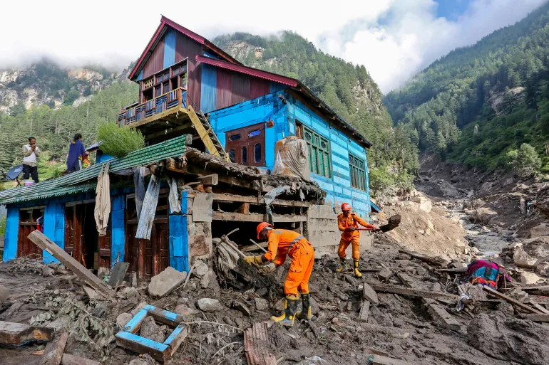
Indian National Disaster Response Force (NDRF) personnel conduct a search and rescue operation at the site of a flash flood at a village in the Kishtwar district of Indian-administered Kashmir on August 16, 2025 [AFP]
Kashmir’s warning signs
Thousands of kilometres away, scientists studying Kashmir’s Himalayas are seeing another part of the same problem.
A study published in the Journal of Glaciology this year mapped 155 glacial lakes above 2,500 metres (8,200ft) across the Himalayas in Indian-administered Kashmir.
The researchers found that the area of ice-contact proglacial lakes – bodies of water that form directly against the margin of a melting glacier, trapped by moraine ridges, bedrock basins, or ice dams – had increased by 26 percent between 1992 and 2024.
Five lakes were classified as having very high susceptibility to glacial lake outburst floods.
An outburst from those lakes, the researchers found, could threaten several thousand buildings, 15 major bridges, roads and a hydropower project.
More significantly, the study warned that hazards could occur in chains, with an upstream lake outburst potentially triggering secondary events downstream.
For Irfan Rashid, a glaciologist and associate professor at the University of Kashmir who co-authored the study, the implications extend beyond individual lakes.
Rashid recently told Al Jazeera that without action, the melting, thinning, and destabilisation of glaciers, seasonal snow cover, and permafrost along the Hindu Kush-Himalayas system would increase, and water shortages could become a major problem across the Upper Indus, Ganga and Brahmaputra basins by the end of the century.
That is why the Nepal disaster resonates in Kashmir.
The landscapes are different, the rivers are different and the individual hazards may differ. But the underlying problem is increasingly similar: Communities living downstream of a rapidly changing high-altitude environment may have little time to respond when something breaks loose above them.
The challenge is particularly acute in places where roads, bridges and hydropower projects occupy narrow valleys.
Once a mountain river begins carrying enormous quantities of rock, ice and mud, infrastructure designed for conventional floods can quickly become irrelevant.
Volunteers rescue flood-affected victims along with their livestock using a boat following heavy rains and overflowing of the Sutlej River, on the outskirts of Multan in Punjab province, Pakistan, on September 4, 2025 [Shahid Saeed Mirza/AFP]
Pakistan has already begun building a warning network
The same concern runs across the western Himalayas and Karakoram ranges.
The Gilgit-Baltistan region in Pakistan-administered Kashmir contains hundreds of glaciers and glacial lakes, while communities and infrastructure sit along valleys exposed to sudden floods and landslides.
Pakistan has responded by expanding early-warning infrastructure.
Under a United Nations-supported programme, early-warning systems, evacuation shelters, disaster-management centres and other protective measures have been established in vulnerable valleys.
But technology alone cannot solve the problem. A sensor can detect a change. Someone still has to receive the message. Someone has to understand what it means. And people downstream have to have a route to safety.
That last part is often the weakest link. A siren is useful only if the people hearing it know where to go. An automatic warning is useful only if it arrives before the flood. A satellite image is useful only if the information can be converted into a decision quickly enough to save lives.
This is why disaster scientists increasingly talk about anticipatory action rather than simply disaster response.
“The era of preparing for a single, predictable hazard is over,” Sanyal said earlier this year. “Anticipatory action and early warning must now be the foundation.”
Nepal army soldiers work during a search and rescue operation outside a tunnel near a hydropower project site, following deadly flash floods and mudslides, in Rasuwa district, Nepal, on September 1, 2026 [Reuters]
The infrastructure trap
The Himalayas are also becoming more heavily engineered.
Hydropower is central to Nepal’s economy. Roads are being expanded. Border crossings are growing in importance. Tourism is pushing deeper into remote valleys.
The benefits are obvious. So are the risks.
The August disaster struck an area where hydropower infrastructure was concentrated along the river corridor. At least 900 workers were believed to have been inside tunnels and other facilities in the aftermath, making rescue operations extraordinarily difficult. Two workers were eventually pulled alive from a hydropower tunnel nine days after the disaster.
The question is no longer simply whether infrastructure can withstand a flood. It is whether planners have adequately considered what happens when a flood is carrying an enormous mass of rock and ice, when a river changes course, or when one mountain hazard triggers another.
For decades, engineering risk assessments have often relied on historical records. But history becomes a less reliable guide when the physical conditions producing disasters are changing.
A river that flooded once every several decades may no longer behave according to the same pattern. A glacier that appeared stable from satellite imagery may sit beneath an increasingly unstable slope. A lake that was considered remote may suddenly become a threat to a road, village or power plant hundreds of metres below.
Relatives of victims and missing people react outside the morgue of the Tribhuvan University Teaching Hospital (TUTH), in Kathmandu, Nepal, August 29, 2026 [Narendra Shreshtha/EPA]
The border problem
There is another complication that no satellite can solve on its own.
Borders.
The Himalayas are divided among countries with different political systems, security concerns and approaches to sharing information. But rivers do not stop at international boundaries. Neither do floods.
The August disaster reached the Nepal-China border and damaged the Gyirong crossing, an important trade and pilgrimage route. The disaster also raised questions about how quickly information about hazards in high mountain areas can move between countries.
This is where regional cooperation becomes more than a diplomatic slogan, experts say. A sensor positioned in one country can provide warning to people in another. A satellite image collected over one mountain range can reveal a developing hazard that threatens a valley downstream. A river gauge can provide critical information before floodwaters reach a settlement.
The technical capability already exists in many cases. The missing piece is often the architecture connecting it.
A 2026 assessment of Himalayan disaster risks has argued for stronger monitoring, early-warning systems and regional coordination because hazards are increasingly interconnected.
The idea is simple: Information about a mountain hazard should not stop at the same line where a political boundary begins.
Buildings are inundated after flash floods triggered by sudden heavy rainfall swamped Rangpo town in Sikkim, India, Friday, October 6, 2023 [Prakash Adhikari/AP Photo]
From Nepal to Sikkim to Kashmir
The August disaster in Nepal isn’t a tragedy belonging to one country, point out experts.
The Kashmir Himalayas study has already identified lakes capable of producing destructive outburst floods and has warned of cascading processes.
Northeast India’s Sikkim provides another example.
Today, 40 high-risk glacial lakes have been identified in Sikkim, including 16 placed in the highest-risk category, with authorities working on drainage, flood-retention and other protective measures.
But the lesson from each disaster is broadly the same: Waiting for a disaster to prove the risk is the most expensive form of preparedness.
The world’s second largest mountain, the 8,611-metre- (28,251ft-) high K2 (seen in the distance), and the 8,051-meter- (26.414ft-) high Broad Peak (R), are illuminated by the moon at Concordia, the confluence of the Baltoro and Godwin-Austen glaciers, in the Karakoram mountain range in Pakistan, September 7, 2014 [Wolfgang Rattay/Reuters]
The Third Pole test
The Himalayas are sometimes called the Third Pole because they contain one of the world’s largest concentrations of snow and ice outside the Arctic and Antarctic.
Major Asian rivers depend on water originating in these mountains. Hundreds of millions of people live downstream.
That makes the changing Himalayas not only an environmental issue but a security, infrastructure and humanitarian one.
The August disaster demonstrated the most frightening version of that future. A mountain can collapse without warning. A river can become a weapon of debris. A hydropower tunnel can become a trap. A border crossing can disappear in minutes. And by the time people downstream understand what is happening, the water may already be there.
It’s a future that a region stretching from northeast India, spanning Tibet, Nepal, Kashmir and Pakistan, can no longer ignore. Yet disaster management remains largely divided by national boundaries. That contradiction is becoming harder to navigate.
The next glacial collapse could begin in Kashmir. It could begin in Pakistan’s high mountains. It could begin in Sikkim, Nepal or Tibet.
Wherever it starts, the same question will follow the mountain downstream: Who knew, how early did they know, and did the warning reach the people in time?
For a region entering an era of increasingly complex mountain hazards, that may be the real measure of whether the Third Pole is prepared.
France is accelerating work on the Rafale F5 standard, bringing forward development of a major new configuration of its combat aircraft at a time when the country’s planned next-generation fighter with Germany has effectively collapsed in its original form. The contracts cover the equipment judged to have the highest technical risk, ahead of the overall development contract for the F5 standard, expected for the end of this year.
The French defense procurement agency, the Direction générale de l’armement (DGA), ordered the first upstream development work for F5 from Dassault Aviation, Thales, MBDA, and Safran. The contracts cover key areas including navigation, datalinks, radar, electronic warfare, and propulsion, laying the groundwork for the next configuration of the Rafale, which is planned to enter service with the French Air and Space Force and the French Navy starting around 2033.
The most extensive modernization of the Rafale yet, the F5 standard was originally part of a longer transition toward France’s next-generation combat-air capability. But with the Franco-German New Generation Fighter (NGF) effort now effectively dead in its original configuration, the accelerated F5 program is taking on a much larger strategic role.
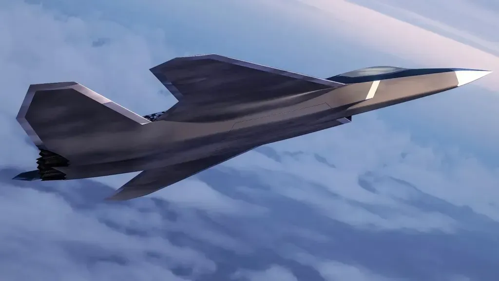
Concept artwork of the NGF future fighter. Dassault Aviation
Rather than simply keeping the Rafale relevant until NGF arrives, France is now developing a version of the aircraft that is set to carry much of the country’s high-end combat-air capability well into the 2030s and potentially beyond.
The increasingly capable F5 could, in turn, reduce the urgency of finding a replacement for the Rafale — while potentially adding to the fighter’s export appeal. After a slow start, Dassault has recorded export sales of 299 new-build Rafales to eight nations.
The DGA’s contracts engage four of France’s principal combat-aircraft industrial players. Dassault Aviation remains responsible for the aircraft and its overall integration; Thales is involved in major sensor, electronic warfare, and communications capabilities; MBDA is responsible for much of the weapons system; and Safran is responsible for propulsion.
The Rafale assembly line at the Dassault Aviation facility in Mérignac, France. Dassault Aviation – V. Almansa ALMANSA
Previous Rafale standards have largely consisted of incremental upgrades, focusing on software and other improvements to the existing aircraft configuration. F5 is notably more extensive, addressing many of the critical systems that determine how the aircraft senses the battlespace, communicates with other platforms, conducts electronic warfare, and generates the power needed to operate increasingly demanding equipment.
The DGA has specifically identified the Thales RBE2-XG radar as one of the major technological advances associated with F5.
The RBE2-XG is expected to feature gallium nitride (GaN) semiconductors. Compared with previous technology, GaN generates less heat and has the capacity to operate at higher voltages, meaning that output power can be increased, while component size can be reduced. Overall, using GaN should help to get more power out of the radar without increasing its size.
According to the DGA, “This new radar will benefit from a substantial increase in power, and consequently in detection range, as well as improvements in the identification of targets with an extremely low radar cross-section (RCS). Its computing capabilities will also be enhanced to facilitate the integration of artificial intelligence.”
The RBE2-XG will also be “designed with collaborative combat in mind, featuring sensors capable of working together without the need for pilot intervention.” It is also planned to have enhanced resilience, including against cyber threats.
France is already working on the concept of a combat drone to accompany the Rafale, with the future F5 standard providing the crewed aircraft around which those systems can operate.
A Rafale during a test mission with a Dassault nEUROn combat drone demonstrator. Dassault Aviation – A. Pecchi
The new radar will be combined with more capable electronic warfare equipment, improved communications and datalinks, expanded processing capacity, and a more capable propulsion system.
To be developed by MBDA and Thales, the forthcoming F5 version of the SPECTRA self-protection suite is intended to significantly improve detection and jamming capabilities, the DGA says, “through a fully digital approach, enabling a complete overhaul of the core electronic warfare system to counter the increasing density and broadening of the threat spectrum, as well as the growing complexity of threat waveforms, expected by 2035.”
Thales à bord du Rafale de Dassault Aviation
Thales will also be responsible for the new Inter-Vehicle Data Link (IVDL) system, described as a “stealthy and resilient datalink.” The DGA says the new datalink will expand connectivity “thanks to a new high-speed, discreet, and jamming-resistant waveform. IVDL will allow the Rafale to penetrate hostile areas where jammers are widespread, while maintaining optimal quality of communication and dialogue between aircraft.”
Safran will begin preliminary design work on the M88 T-Rex engine, which is planned to increase the turbofan’s thrust from around 16,500 pounds to nearly 19,850 pounds, an increase of roughly 20 percent.
M88 T-REX: A 9-ton thrust predator serving the Rafale
In terms of armament, the contract announcement mentions the ASN4G missile, set to be introduced to service by 2035, which will allow the Rafale F5 to continue to serve as the airborne nuclear component. The munition remains in the early stages of development, but it will be capable of hypersonic speeds — defined as speeds greater than Mach 5 — with a range in excess of 1,000 kilometers (621 miles).
Other likely new missiles include a beyond-visual-range air-to-air missile to succeed the current Meteor. As you can read about here, France’s Comet program, apparently led by the French side of MBDA, is already looking into this requirement, with an apparent plan to introduce the weapon around 2030.
An older video from MBDA showing some of the company’s weapons integrated on earlier versions of the Rafale:
PARIS AIR SHOW 2021: MISSILES ON THE RAFALE
For France, the original logic behind the pan-European FCAS program was that Rafale would eventually give way to the NGF as its principal crewed combat aircraft, operating from land bases and aircraft carriers.
With the collapse of the Franco-German effort, France cannot simply wait for a next-generation fighter program whose industrial and political future is uncertain. Instead, the Rafale has to remain capable against rapidly evolving threats throughout the 2030s and beyond.
With the F5 standard, however, France is looking to incorporate some of the concepts envisaged for NGF. These include distributed architectures in which crewed fighters, uncrewed aircraft, remote carriers, missiles, and offboard sensors cooperate across a battlespace.
The nEUROn drone and a Rafale M in flight over the aircraft carrier Charles de Gaulle, during tests to investigate the use of a UCAV in a naval context. Dassault Aviation – A. Pecchi
For now, F5 also sidesteps the central problem in the now-defunct Franco-German effort: whether the two countries could agree on the requirements, industrial structure, and workshare behind a new-generation combat aircraft.
Despite its advances, the F5 airframe remains derived from a design dating back to the 1980s, which first entered French service in the early 2000s. In particular, it falls well short of fifth-generation designs — let alone sixth-generation ones — in terms of low observability. This is one area where collaborative drones could potentially help compensate for the Rafale’s inherent limitations.
France has therefore bought itself some time with the F5 program. But it may eventually decide that it needs a future high-end crewed fighter to provide capabilities that an upgraded fourth-generation airframe cannot fully replicate, particularly in terms of survivability against advanced integrated air-defense systems, signature reduction, internal weapons carriage, and operations deep inside heavily contested airspace.
On an industrial level, F5 is also significant because it brings together the same French industrial heavyweights that would have formed the backbone of its FCAS effort. Dassault Aviation, Thales, Safran, and MBDA are now well-positioned to work together on whatever comes after F5, whether that is a crewed combat aircraft, uncrewed CCA-type platforms, or a combination of both. Based on its experience with the nEUROn program, France would be well placed to develop a UCAV that can work cooperatively as well as independently, taking over the deeper-penetrating fighter mission set, and potentially skipping a sixth-generation fighter altogether.
https://www.youtube.com/watch?v=frNsu7g7r94
Meanwhile, success with F5 — and, in particular, with the wider combat ecosystem planned around it — could put France in an even stronger position when it comes to any future European fighter project.
For the time being, Britain, Italy, and Japan are pursuing the GCAP/Tempest pathway toward a new combat aircraft. Germany and Spain remain tied to the wider FCAS architecture, even as the original Franco-German NGF arrangement has fractured. Sweden’s position is less clear, with indications that it could collaborate with either France or Germany.
France, for its part, is now investing heavily in an increasingly sophisticated Rafale architecture while maintaining its own sovereign industrial base.
In terms of acqusition, France is expected to pursue a mixed approach, buying new-build Rafales while upgrading suitable aircraft already in service to the F5 standard. The oldest jets are unlikely to receive the full F5 treatment, however.
The irony is that the failure of the NGF effort may ultimately make Rafale F5 more important — and potentially more capable — than it was ever expected to be.





![Indian National Disaster Response Force (NDRF) personnel conduct a search and rescue operation at the site of a flash flood at a village in the Kishtwar district of Indian-administered Kashmir on August 16, 2025 [AFP]](https://i0.wp.com/occasionaldigest.com/wp-content/uploads/2026/09/afp_68aac36f5150-1756021615.jpg?w=640&ssl=1)