
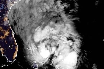
Tropical Storm Imelda gained a bit of strength early Monday and was expected to be a hurricane on Tuesday. Photo courtesy of NOAA
Sept. 29 (UPI) — Tropical Storm Imelda, which formed in the Atlantic on Sunday, strengthened slightly overnight, according to forecasters, who said recent modeling showed the risk of dangerous wind impacts along the southeastern U.S. coast was diminishing.
Imelda, the ninth named storm of the 2025 Atlantic hurricane season, had maximum sustained winds of 45 mph, up 5 mph from late Sunday, the National Hurricane Center said in its 2 a.m. EDT update.
It was located about 130 miles northwest of the Central Bahamas and about 315 miles southeast of Cape Canaveral, Fla., according to the forecasters, who said it was moving north at 8 mph.
“Strengthening is expected during the next few days, and Imelda is forecast to become a hurricane by Tuesday,” the NHC update said.
“On the forecast track, the center of the system is expected to move across the northwestern Bahamas today and then turn east-northeastward, moving away from the southeastern U.S. by the middle part of this week.”
A tropical storm warning is in effect for the Central Bahamas and San Salvador, as well as portions of the northwestern Bahamas.
Eastern Cuba is expected to see 2 to 4 inches of rain, while the northwest Bahamas could receive between 4 and 8 inches through Tuesday, the forecasters said.
“This rainfall will likely produce flash and urban flooding,” NHC said. “Mudslides are also possible in areas of higher terrain across eastern Cuba.”
Coastal southern North Carolina and southeast areas expected to see between 2 and 4 inches of rainfall with a maximum of 6 inches through Tuesday. This could also result in flash and urban flooding, the forecasters warned.
Swells generated by the cyclone, as well as Hurricane Humberto, are affecting parts of the Bahamas and are predicted to spread to the southeast U.S. coast early next week.
The potential for swells could cause life-threatening surf and rip current conditions, NHC said.