Microsoft warns customers of ‘increased latency’ in connectivity and says efforts are under way to resolve the issue.
Published On 7 Sep 20257 Sep 2025
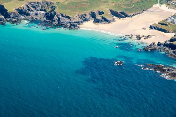
Internet disruptions have been reported in the Middle East and South Asia after multiple undersea cable cuts in the Red Sea, tech giant Microsoft, which has been criticised for its links to Israel as its war on Gaza rages on, said in a statement.
The statement on Sunday did not give further details about what caused the cuts.
Recommended Stories
list of 2 itemsend of list
In a status update published to its website, Microsoft said “network traffic traversing through the Middle East may experience increased latency due to undersea fiber cuts in the Red Sea”. The global software giant said its Azure cloud computing services, the world’s second largest after Amazon, were affected by the cuts but added that general network traffic was not impacted.
“Network traffic that does not traverse through the Middle East is not impacted. We’ll continue to provide daily updates, or sooner if conditions change,” it said.
Microsoft said the disruptions started at 05:45 GMT on September 6.
The internet connectivity watchdog NetBlocks reported “degraded” internet connectivity in several countries, including Saudi Arabia, Pakistan, the United Arab Emirates and India, “resulting in slow speeds and intermittent access”.
NetBlocks said the connectivity issues were due to failures in the SMW4 and IMEWE cable systems near Jeddah, Saudi Arabia.
Pakistan Telecommunications, one of the country’s largest telecoms providers, released a statement on X warning customers that the country “may experience some degradation during peak hours”, adding that its international partners were working to resolve the issue.
Undersea cables form the internet’s backbone, carrying global data traffic. The Middle East serves as a critical hub linking Asia and Europe. They are vulnerable to damage by ships’ anchors, but can also be targeted in attacks, which can cause widespread disruption.
In early 2024, Yemen’s internationally recognised government-in-exile alleged that the Houthis planned to attack undersea cables in the Red Sea. Several were cut, but the Houthis denied being responsible.
On Sunday morning, the Houthis’ Al Masirah TV acknowledged the cuts, citing NetBlocks.
Microsoft’s Azure has been storing information, including intercepted Palestinian phone calls in the occupied West Bank and the Gaza Strip for Israel’s military, according to an investigation by The Guardian, +972 Magazine and Local Call.
Microsoft has denied knowledge that Israel’s cyber-intelligence division, Unit 8200, was using its cloud services for material obtained through mass surveillance, but launched an investigation in August.
Microsoft has fired four employees who participated in protests on company premises over the firm’s ties to Israel.
Weekly insights and analysis on the latest developments in military technology, strategy, and foreign policy.
The U.S. Navy, together with 11 of America’s allies, is working to develop a follow-on to the Block 2 version of the RIM-162 Evolved Sea Sparrow Missile (ESSM). The ESSM is an air defense staple on a wide array of American and foreign naval vessels, but concerns about an increasingly complex aerial threat ecosystem are now driving interest in a missile with improved capabilities.
The Office of Naval Research (ONR) posted a notice online yesterday inviting prospective contractors to a meeting in October to discuss what is currently described as a “Next Significant Variant (NSV) missile system” to succeed the ESSM Block 2. NavalX, a technology incubator within ONR charged with fostering innovation for the Navy and Marine Corps, is currently partnered with the NATO SEASPARROW Project Office (NSPO) on this effort. The NSPO consortium, which dates back to 1968, currently includes the United States, Australia, Belgium, Canada, Denmark, Germany, Greece, the Netherlands, Norway, Portugal, Spain, and Turkey. Despite the name, Australia is not a member of NATO, but is one of America’s top allies. The U.S. arm of NSPO falls under Naval Sea Systems Command’s (NAVSEA) Program Executive Office for Integrated Warfare Systems (PEO IWS).
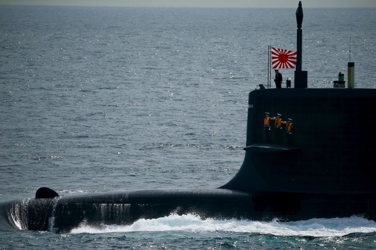
A RIM-162 Evolved Sea Sparrow Block 2 missile. Canadian Department of National Defense
The ESSM is a short-to-medium range surface-to-air missile primarily designed to offer an additional layer of defense against anti-ship cruise missiles (ASCM), but that is also capable of engaging other aerial threats. The baseline semi-active radar-guided Block 1 ESSM, which evolved from the earlier RIM-7 Sea Sparrow surface-to-air missile, itself based on the AIM-7 Sparrow air-to-air missile, was developed in the 1990s and entered service in the early 2000s. The Block 2 version, which began entering service in the early 2020s, features a much-improved seeker with semi-active and active modes, the latter of which does not require a radar on the launching ship to ‘illuminate’ the target. It also has a data link so the missile can receive targeting updates after launch, an especially useful capability for longer-range engagements.
“The NSPO is exploring technology to be incorporated into a Next Significant Variant (NSV) missile system,” yesterday’s notice says. “This successor to the ESSM Block 2 must be able to engage current and future threats while maintaining existing quad-pack sizing with a 10” missile diameter.”
The ESSM’s ability to be quad-packed into Mk 41 Vertical Launch System (VLS) cells, giving ships valuable added magazine depth, is another one of the missile’s key features. Ships equipped with Mk 48, Mk 56, or Mk 57 VLS arrays, as well as deck-mounted Mk 29 box launchers, can also use them to fire ESSMs.
“To develop the NSV missile system, the NSPO will lean heavily on digital engineering and model-based systems engineering to communicate missile designs and requirements efficiently among consortium nations and industry partners in a shared development environment. These tools will be used to evaluate weapon systems and missile technologies through a design alternative evaluation process,” the ONR notice explains. “White papers are expected to include all aspects of the NSV missile including seeker technologies, autopilot, computing stack, internal communications, rocket motor alternatives, warhead design, missile to missile communications, data links, combat system integration, etc.”
No specific requirements are laid out in the notice. A multi-mode seeker that incorporates an imaging infrared (IIR) capability is one feature commonly discussed in the context of future anti-air missiles. An IIR mode would be immune to electronic warfare jamming and would not be impacted by a target’s radar-absorbing or deflecting stealth features. As a passive seeker mode, it would also not pump out signals that a threat could detect to alert them that they are being targeted. A new highly loaded grain rocket motor could also offer extended range without changing the missile’s form factor. These are just some of the possible features that could be included in a successor to the ESSM Block 2.
“The Next-Generation Highly Loaded Grain project team has matured the technology and seeded the development of future mission-modular propulsion systems that can increase weapon ranges by up to 1.5x while maintaining inner boundaries for short-range and time-critical… pic.twitter.com/gA7mlcSSi7
The notice about the NSV missile system does say that “potential industry partners,” as well as “existing” ones, are welcome at the upcoming meeting on the NSV missile system, which would seem to at least leave open the possibility of a follow-on to the ESSM Block 2 that has a substantially different design.
“Drivers for development include stressing simultaneous engagement scenarios, the need to develop fully releasable technologies using open architecture standards for all consortium partners to openly share, and the need to maintain capability with current consortium systems to the greatest extent possible while limiting ship support,” the notice also says, without further elaborating.
It is worth noting here that the Block 2 variant of the ESSM was itself developed in response to what the Navy described as a need for improved “capability against the most stressing ASCM threats in challenging environments.”
An old Navy briefing slide discussing the differences between the Block 1 and Block 2 ESSMs, as well as driving factors behind the Block 2’s development. USN
Navy warships, as well as those belonging to other members of the NSPO consortium, now face an aerial threat matrix that includes even more advanced supersonic, as well as hypersonic ASCMs. There is also the increasing likelihood that they could be layered in with anti-ship ballistic missiles and multiple tiers of drones, creating additional complexity for defenders. While an ESSM successor would not be tasked with ballistic missile defense, improved capability against other threats would give the crew of a ship greater flexibility to respond to an incoming complex attack. The Navy has been trying to accelerate work on high-power microwave directed energy weapons for the same general reasons.
The US Navy’s Arleigh Burke class destroyer USS Carney fires a Standard Missile-2 (SM-2) against a Houthi threat while sailing in the Red Sea in October 2023. USN The US Navy’s Arleigh Burke class destroyer USS Carney fires an SM-2 missile at Houthi aerial threats on October 19, 2023. USN
U.S. lessons learned from naval operations against the Houthis, as well as in the defense of Israel from Iran on multiple occasions since April 2024, have underscored the importance of magazine depth, even in the face of attacks involving relatively modest volumes of threats. Those experiences have also highlighted the vital need for at-sea reloading capabilities. Navy ships would be subjected to a wider array of threats in substantially larger volumes, and would burn through interceptors at a higher rate, in any future high-end fight, such as one against China in the Pacific.
Overall, much remains to be learned about the plans for a follow-on to the Block 2 ESSM, but there are clear threat drivers that would prompt a desire for a successor.
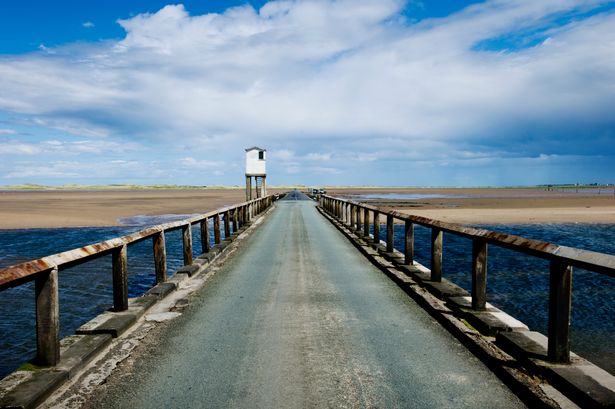
While this road doesn’t sound real – it certainly is, there are a dozen over the world but for the UK – there is only one which leads to the ‘Holy Island’ – but some get stuck
At high tide the road is submerged and Holy Island becomes an island again(Image: Getty Images/iStockphoto)
For many, this sounds like a made up road, something you may hear about but never see.
But for some living on the northeast coast of England – this isn’t a fairytale but the only road connecting to ‘Holy Island’. The Lindisfarne causeway is swallowed by the north sea twice every day and at certain parts of the day – you may not even be able to tell where it is located.
It sure is magical – but is very dangerous. For visitors, the disappearing act is part of the allure. The drive itself feels surreal: a strip of road gliding over glistening sands, marked by wooden poles that guide you towards the island.
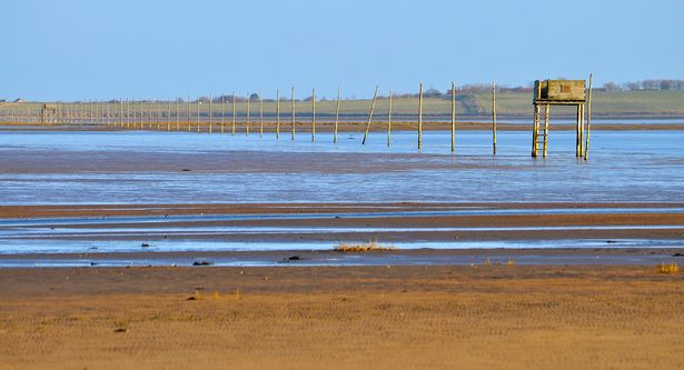
The road leads to the ‘Holy Island’(Image: Getty Images)
At low tide, it looks like an open invitation; at high tide, it’s as if the road never existed. And it happens fast, the sea doesn’t creep in politely, it races across the sand and covers the tarmac in minutes.
“The Lindisfarne Causeway is unlike any other road in the UK. If you’re planning to drive it, always check the official tide timetable first – don’t rely on sat-navs. The sea comes in quickly, and once the water starts covering the road, it’s already too late, said experts at Show Plates World.
Why do people choose to go?
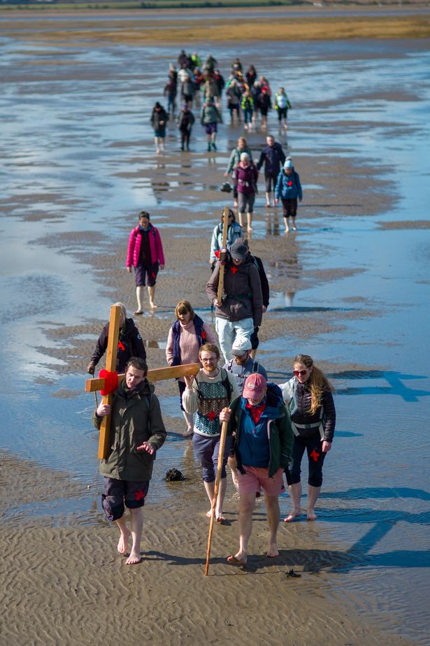
With Holy AIsland having so much history and charm – many run to the opportunity to visit and the tidal road is the only way. The island is home to the haunting ruins of Lindisfarne Priory which is birthplace to Lindisfarne Gospels and the well known castle.
Pilgrims travelled to the island for centuries and today, visitors are continuing the tradition – some travel by car while others walk across the tidal sands at a low tide.
The island has a lot to offer(Image: Flickr Vision)
However, besides the history of the island – it also offers sandy beaches that stretch on for miles, attracting huge flocks of migrating birds and the village pubs serve Northumberland seafood.
The island even produces its own mead, first brewed by monks hundreds of years ago. But for a lot of people, it’s just for the thrill the tidal road brings.
How long do you have before the road disappears?
The causeway is only safe to cross during low tide, usually for around seven hours between each high tide. That means two “safe windows” every day, published by Northumberland County Council. Locals swear by it, tourists sometimes ignore it and that’s when trouble strikes.
Many people each yet get stuck(Image: Getty Images)
Each year, unlucky or overconfident drivers end up stuck in the refuge box halfway across, waiting for the tide to drop or at worst, the coastguard to pluck them to safety.
It’s certainly a road trip you can never forget and one of the most unforgettable drives in Britain, but if you are travelling to Holy Island, make sure you check low tide times, otherwise you could end up stranded for a few hours
Footage shows cars parked in the Cornish seaside town of Polzeath as the tide rises around their tyres, with visitors rushing to rescue their vehicles before they are submerged.
A tourist who left their car at Polzeath beach got a nasty shock when they returned (Image: UCG, UCG/Universal Images Group via Getty Images)
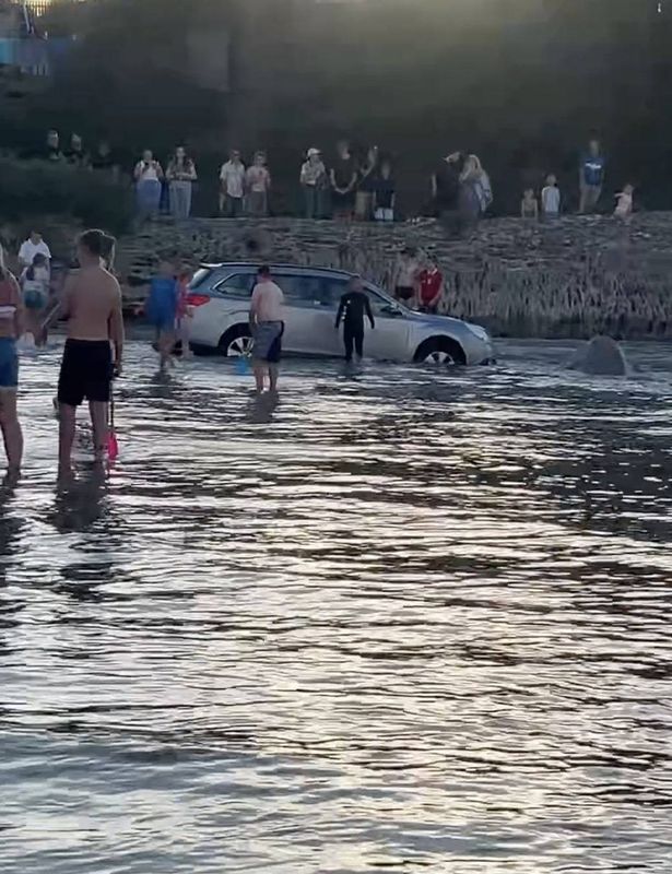
Holidaymakers visiting the Cornish seaside town of Polzeath were left stunned to discover their cars slowly disappearing beneath the waves over the bank holiday weekend.
Video footage captures vehicles parked in the town on Cornwall’s north coast as the tide creeps up around their wheels, with panicked visitors scrambling to save their cars before they vanished underwater.
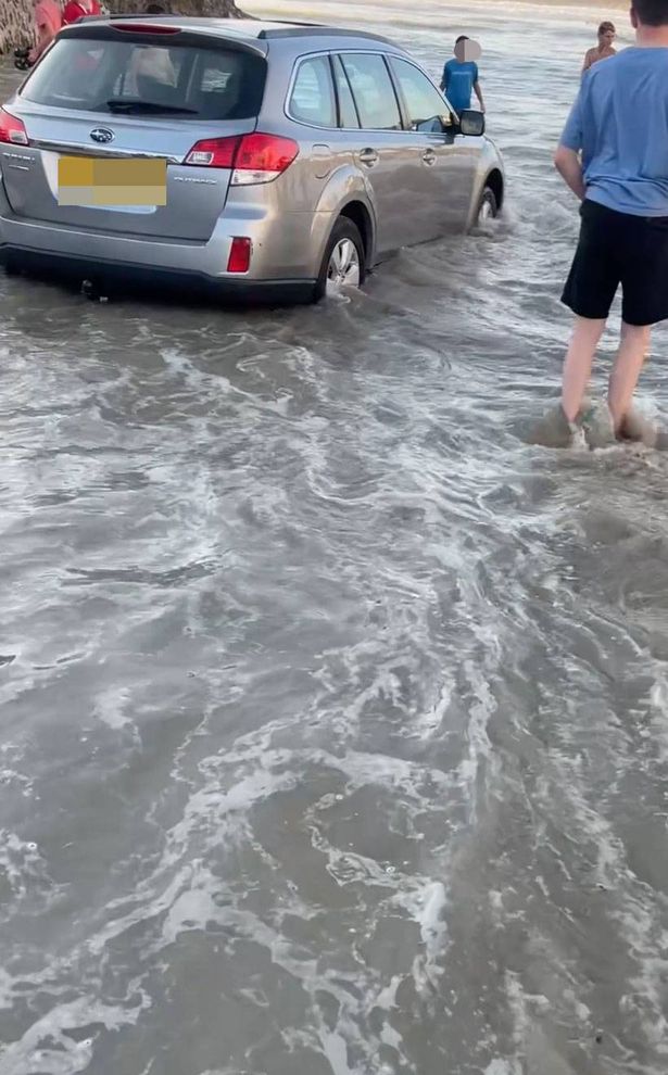
Dramatic scenes showing a 2010 Subaru Outback in danger were filmed by 34-year-old Sam Peters, who witnessed the mayhem as good Samaritans rallied to help the motorist retrieve their vehicle.
He said: “Everyone was panicking and it caused much distress. Many onlookers were surprised and concerned, and some tried to help.
“Several cars got caught in the rising tide and became stuck on the beach. The car finally got pushed out by many supporters on the beach.”
This marks yet another occasion that tourists and residents have witnessed cars stranded by the waves at Polzeath, reports Cornwall Live.
People attempting to rescue one of the cars(Image: Sam Peters / Jam Press)
Further footage, filmed in May, revealed a Mini falling foul of the tide on the same stretch of sand. The clip, recorded by the Polzeath Beach Ranger Service, depicted the vehicle parked and encircled by water.
In a Facebook post, they cautioned drivers about the perils of parking on sand. They said: “If you drive over seaweed to get to your parking space, consider how the seaweed might have been delivered.”
Despite the cheeky comment, the service confirmed that the owner managed to rescue their car before it was carried off during one of the May bank holidays.
People attempting to rescue a car(Image: Sam Peters / Jam Press)
A spokesperson for the service, speaking to Cornwall Live, offered some advice to drivers on how to avoid a similar situation.
They explained: “On this occasion, the tide was at its highest that day, but we do sometimes have higher spring tides. Many factors affect the height of the tide, including sun and moon phases, wind, waves and atmospheric pressure.
“It’s a beach car park – one of the last in the region – and it serves as a valuable resource for tourism and the community. It also helps to raise money to pay for necessary services like lifeguards, beach cleaning, road sweeping, bin emptying and toilets.
“As with all coastal destinations, there are risks associated with tides, weather and the landscape, and we encourage visitors to be aware of that. There are visible warning signs.”
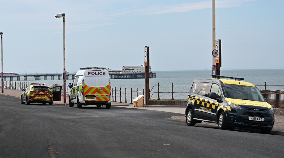
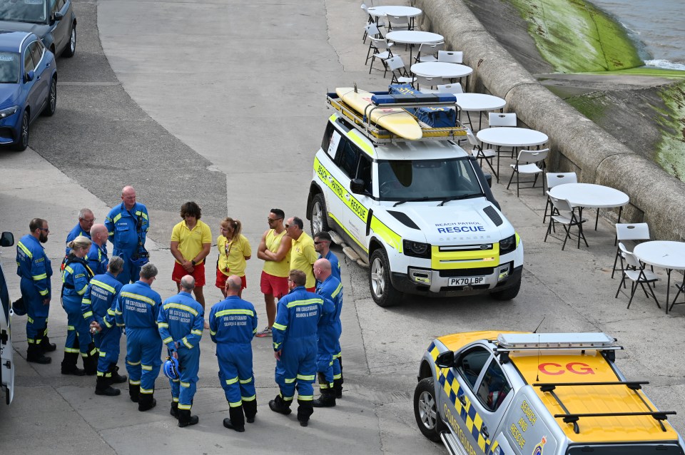
A spokesperson for the force said: “We were called at about 10am today, August 25, following reports a woman had been pulled from the sea opposite the Belvedere Hotel at Blackpool.
“Despite the best efforts of emergency services at the scene and at the hospital, the woman sadly later died.
“Following enquiries, the woman, in her thirties, has now been identified and her next of kin has been informed.
“Our thoughts are with her loved ones.
“The death is not being treated as suspicious, and a file will be prepared for HM Coroner.”
3
Locals noted a massive emergency services presence on the Promenade
Beachgoers love the ‘hidden gem’ swimming spot with clear water and stunning views
The idyllic spot is popular with beach lovers(Image: Getty)
With more sunny weather on the way, beachgoers will be searching for the perfect spot to get away from it all. For anyone lucky enough to find themselves near Cornwall, a social media user has found a ‘hidden gem’ spot.
Of course, there is no shortage of stunning bays along the Cornish coast, and most will be familiar to locals. However, for those travelling from further afield, Treyarnon Bay Beach might be a lesser-known spot that’s well worth a visit.
Found in North Cornwall, the beach is approximately 11 miles from Newquay, and dogs are allowed all year. The Cornwall Beach Guide says: “Treyarnon Bay Beach is an excellent family beach with lots of sand and rock pools and can be used for surfing.”
The stunning spot was recently showcased in a TikTok video by @hannahrebecca__, who told followers: “You need to visit this hidden gem in the UK.” Meanwhile, her video showed families jumping off rocks into the clear water. An impressed commenter wrote: “Soooo blue.” Hannah replied: “Just so pretty.”
Treyarnon Bay Beach is popular with visitors on Tripadvisor, where it is ranked as one of the best things to do in St Merryn. One reviewer wrote: “What a stunning place. If food and drinks are your thing, visit Treyarnon beach. If diving into blue lagoons and rock pools is your thing, visit Treyarnon beach.
Content cannot be displayed without consent
“If lounging around on beautiful sandy beaches watching the sea wash up onto the sand is your thing, visit Treyarnon beach. Rock pooling, building sand castles, swimming, relaxing, what ever you like to do – you don’t need to go on a plane to anywhere else in the world with places like this in England. Breathtakingly stunning. A must visit if you’re in Cornwall!!”
Another praised: “Incredible bay with beautiful beach and surfers worth watching! Dog friendly enabling our Staffy to have a great time chasing his football up and down the beach. With the tide out there are some amazing “secret” rock pools with some large and deep enough to swim in!”
A different response read: “What a fabulous bay. Great for wave watching/jumping/boards although strong currents so make sure you stay between the lifeguard flags. The tide goes out a long way revealing rock pools as well as a tidal pool.
The beach has glowing reviews on Tripadvisor (Image: Getty)
“All day parking was £5 (June 2025) and there is a little shop, burger van (great burgers!) and ice cream van. Toilets were available at the YHA. Coastal path takes you round to Constantine bay which is also lovely.”
Someone else said: “Superb beach. Probably my fave beach along with Mawgan Porth, with Constantine a short yet beautiful coastal walk away. Great facilities, lots of rock pools to discover. A definite must to visit if you love sandy beaches and crystal blue sea and waves to surf/bodyboard in.”
Kuala Lumpur, Malaysia– When four Chinese vessels joined with Russian ships earlier this month in joint naval drills in the Sea of Japan, few eyebrows were raised.
Moscow and Beijing have been reinforcing their military partnership in recent years as they seek to counterbalance what they see as the United States-led global order.
But what did raise eyebrows among defence analysts and regional governments had occurred several weeks earlier when China sent its aircraft carriers into the Pacific together for the first time.
Maritime expert and former United States Air Force Colonel Ray Powell described the “simultaneous deployment” of China’s two aircraft carriers east of the Philippines as a “historic” moment as the country races to realise Chinese President Xi Jinping’s ambition of having a world-class navy by 2035.
“No nation except the US has operated dual carrier groups at such distances since [World War II],” said Powell, director of SeaLight, a maritime transparency project of the Gordian Knot Center at Stanford University.
“While it will take years for China’s still-nascent carrier capabilities to approach that of America’s, this wasn’t just a training exercise – it was China demonstrating it can now contest and even deny US access to crucial sea lanes,” Powell told Al Jazeera.
China’s state-run news agency Xinhua described the exercise by the aircraft carriers as a “far-sea combat-oriented training”, and the state-affiliated Global Times reported that China was soon poised to enter the “three-aircraft-carrier era”, when its Fujian carrier enters service later this year.
East Asia is a ‘home game’ for China
China currently has two operational aircraft carriers – the Liaoning and Shandong – and the Fujian is undergoing sea trials.
While the Chinese navy operates the world’s largest naval fleet with more than 370 ships compared with the US’s 251 active ships in commission, Beijing still lacks the global logistics network and advanced nuclear submarine technology required of a truly mature blue water force, Powell said.
Beijing’s three aircraft carriers run on diesel compared with Washington’s 11 carriers, all of which are nuclear powered.
“[China] fully intends to close these gaps and is applying tremendous resources toward that end, and with its rapidly improving technical prowess and vastly superior shipbuilding capacity, it has demonstrated its potential to get there,” Powell said.
Beijing’s more immediate focus is not directed towards competing with the US globally, Powell added.
Rather, China is focused on changing the balance of power and convincing its allies and adversaries to accept China’s dominance within its chosen sphere of influence in East Asia.
The second option, if ever necessary, is to defeat them.
“East Asia is a ‘home game’ for China – a place where it can augment its small carrier force through its far larger land-based air and rocket forces – including so-called [aircraft] ‘carrier killer’ missile systems that can strike targets up to 4,000km [2,485 miles] away,” Powell said.
Regionally, while the Philippines engages in increasingly frequent high seas confrontations with the Chinese coastguard, it is Japan that is watching China’s naval build-up with concern, experts said.
Japan’s Defence Minister Gen Nakatani said in June – after confirming that China’s two carriers had operated simultaneously in the Pacific for the first time – that Beijing apparently aims “to advance its operational capability of the distant sea and airspace”.
With the US increasingly perceived as becoming more inward-looking under President Donald Trump, Japan is considered a growing force in the contested maritime terrain in the Asia Pacific region amid what Tokyo has called “the most severe and complex security environment since the end of World War II”.
‘Preparation for a more uncertain future’
Even before Trump’s second stint as US president, Japan had embarked on the most pivotal shift in post-World War II military spending.
Tokyo’s defence spending and related costs are expected to total 9.9 trillion yen (about $67bn) for fiscal year 2025, equivalent to 1.8 percent of Japan’s gross domestic product (GDP), and the government has committed to raising spending on defence to 2 percent of GDP by 2027, according to Japanese media reports.
“[Japan’s] naval capacity is growing steadily, not just in support of the US alliance but in quiet preparation for a more uncertain future – perhaps even one in which America withdraws from the Pacific,” said Mike Burke, lecturer at Tokyo-based Meiji University.
Collin Koh, senior fellow at the Singapore-based Institute of Defence and Strategic Studies (IDSS), also said that China’s growing military might, assertiveness and proclivity to resort to coercive behaviour have “aggravated Japan’s threat perception”.
But Japan alone cannot guarantee security in such a regional hotspot as the South China Sea, said Burke.
Instead, Tokyo’s goal is to check Beijing’s growing power through a Japanese presence and building partnerships with other regional players.
This year alone so far, Japan has deployed two naval fleets to “realise” what Japanese officials describe as a free and open Asia Pacific region. The first fleet was deployed from January 4 to May 10 and docked in 12 countries, including Malaysia, Singapore, the Philippines, Saudi Arabia, Bahrain and Oman.
The second was deployed on April 21 and is ongoing until November, with port calls in some 23 countries, as well as roles in multilateral military exercises.
Sailors stand on board the Kokuryu submarine of the Japanese Maritime Self-Defence Force during its fleet review at Sagami Bay, off Yokosuka, south of Tokyo, in 2015 [File: Thomas Peter/Reuters]
Japan aims to build trust with other allies, Burke said, noting that Japan has worked on its soft power by funding radar systems, investing in civil infrastructure from ports to rail networks in Southeast Asia, and supporting maritime domain awareness initiatives in the region.
Noriyuki Shikata, Japan’s ambassador to Malaysia, described Tokyo’s approach as a strength at home and reinforcing collaboration abroad with “like-minded countries and others with whom Japan cooperates”, in order to uphold and realise a free and open international order.
“Japan has been strengthening its defence capabilities to the point at which Japan can take the primary responsibility for dealing with invasions against Japan, and disrupt and defeat such threats while obtaining the support of its [US] ally and other security partners,” the ambassador told Al Jazeera.
Zachary Abuza, professor of Southeast Asia studies and security at Washington, DC-based National War College, said the Japan Maritime Self-Defence Force (JMSDF) is a world-class navy that is focused on building the highest level of capabilities.
Abuza also described Japan’s submarine force as “exceptional”, while it is also building up its capabilities, including more high-end antiship missiles.
“All of these developments should give the Chinese some pause,” Abuza told Al Jazeera in a recent interview.
“That said, they [the Japanese] are nervous about Trump’s commitment to treaty obligations, and you can see the Japan Self-Defence Force is trying to strengthen its strategic autonomy,” he said.
‘Chinese assertiveness could result in an accident’
Geng Shuang, charge d’affaires of China’s permanent mission to the United Nations, said earlier this year that China was committed to working with the “countries concerned” to address conflicting claims in the South China Sea through peaceful dialogue.
He also lambasted the threat posed by the US navy’s freedom of navigation operations in the contested sea.
“The United States, under the banner of freedom of navigation, has frequently sent its military vessels to the South China Sea to flex its muscles and openly stir up confrontation between regional countries,” Geng was quoted as saying by Xinhua.
China claims almost all of the South China Sea, a vast area spanning approximately 3.6 million square kilometres (1.38 million square miles) that is rich in hydrocarbons and one of the world’s major shipping routes.
Vietnam, the Philippines, Taiwan, Malaysia and Brunei are claimants to various parts of the sea.
Ralph Cossa, chairman of the Honolulu-based Pacific Forum research institute, said “the challenge to freedom of navigation is a global one”.
But the challenges posed are particularly worrying when it comes to the rival superpowers China and the US.
“I don’t think anyone wants a direct conflict or is looking to start a fight,” Cossa said.
“But I worry that Chinese assertiveness could result in an accident that it would prove difficult for either side to walk away or back down from,” Cossa said.
Speaking on the sidelines of the Institute of Strategic and International Studies’ Asia Pacific Roundtable 2025 summit in Kuala Lumpur earlier this year, Do Thanh Hai, deputy director-general at Vietnam’s East Sea Institute Diplomatic Academy, said no one will emerge unscathed from an incident in the disputed region.
“Any disruption in the South China Sea will affect all,” he told Al Jazeera.
When the fires this year upended Los Angeles and put into question what it even means to return to normal, I was reminded of a chapter in “California Against the Sea” that had expanded my own understanding of what it takes to truly adapt our built environment — and to reimagine the places that we have come to love and call home.
This chapter, which opens with a radical shoreline reconfiguration just north of San Francisco, came not without controversy, but it provided a glimpse into what compromise might need to look like for so many communities struggling to keep up with climate change. Rather than hold the line with increasing futility, here was a humbling example of what can be possible when we transcend the throes of politics — and when we choose to set aside our differences and think beyond just reacting to the same disasters time and time again.
Since the book was published in 2023, the bridge described in the following excerpt has been completed, and the creek is finally free. Accommodating nature in this way called for some tough and unfamiliar changes, but go out to the beach today, and you can see the marsh starting to recover and the entire ecosystem gently resetting with the rhythms of the sea.
So much of the climate debate is still framed around what it is that we have to give up, but does it have to be this way? Rather than confront these decisions as though it’s our doom, can we embrace change and reconsider each effort to adapt as an opportunity — an opportunity to come together and build more bridges to the future?
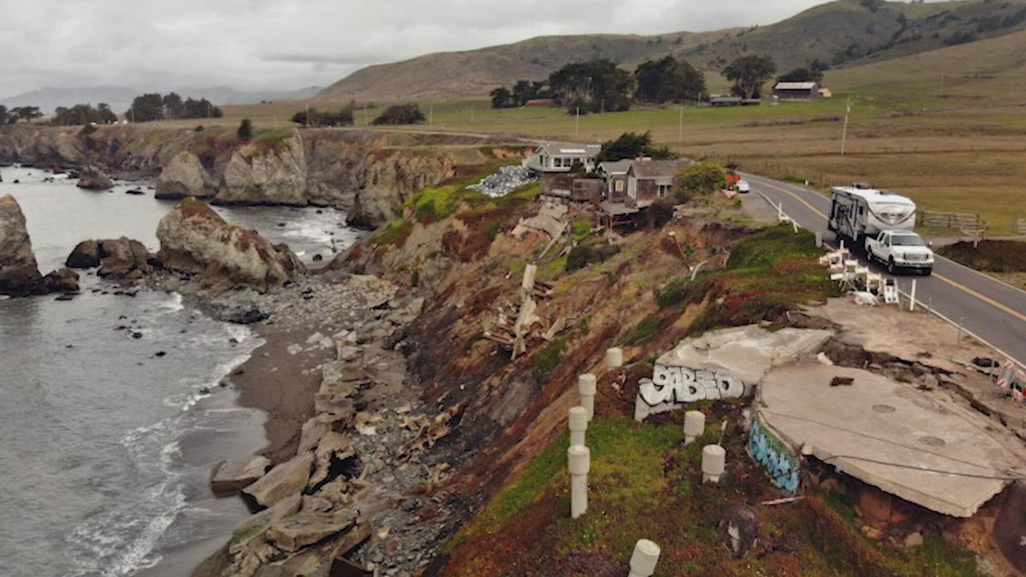
A few winding turns past Bodega Bay, about an hour north of San Francisco, relentless waves pound against a stretch of coastline in dire need of re-imagining. Gleason Beach, once reminiscent of a northern version of Malibu, is now mostly just a beach in name. Sand emerges only during the lowest of tides. Bits of concrete and rebar are all that remain of 11 clifftop homes that once faced the sea. A graveyard of seawalls, smashed into pieces, litters the shore. Here along the foggy bluffs of the Sonoma coast, the edge of the continent feels more like the edge of the world — a window into the future if California does not change course.
Los Angeles knows how to weather a crisis — or two or three. Angelenos are tapping into that resilience, striving to build a city for everyone.
These wave-cut cliffs, a brittle mélange of ancient claystone and shale, have been eroding on average about a foot a year, exacerbated since the 1980s by a hardened shoreline, intensifying El Niños and, now, sea level rise. With the beach underwater, the seawalls destroyed and so many homes surrendered, the pressure is now on Highway 1 to hold the line between land and sea. Year after year, residents have watched the waves carve away at the two-lane road — their only way to get to work, their only way to evacuate, their only way to reach all the rocky coves, beaches and seaside campgrounds that make this coast a marvel.
Broken concrete is all that’s left of a number of clifftop homes at Gleason Beach on the Sonoma Coast, pictured here in 2019.
(Carolyn Cole/ Los Angeles Times)
So, with every storm and every knock from the ocean, officials have scrambled to save the highway, pouring millions of tax dollars into a vicious cycle of sudden collapses and emergency repairs. From 2004 to 2018 alone, state transportation officials spent about $10 million in emergency defenses and failed repairs. In 2019, almost half a mile had to be reduced to one lane.
This lifeline for the region now hangs inches from the edge. The once spectacular coastline had seemingly morphed overnight — an apocalyptic transformation, decades in the making, seen with stark clarity now that orange caution tape and makeshift traffic lights mark what’s left of the shore.
“This is what unmanaged retreat looks like, and it is quite frankly a hot mess of septic systems, old house parts and armoring that have fallen into the intertidal zone with no real mechanism for cleaning it up,” Sonoma County supervisor Lynda Hopkins declared. “If we don’t start planning ahead and taking proactive measures, Mother Nature will make the decisions for us.”
With the realities of climate change looming ever closer, California transportation officials agreed it was time to try something different: make peace with the sea and move the crumbling highway more than 350 feet inland. They knew nailing down the details would be fraught, but, if done right, this would be the first radical effort by the state to plan for a reimagined coast — a coast that could support California into the next century. It was the rare managed retreat proposal that intentionally sought to both raise and relocate critical infrastructure far enough from the shore to make room for the next 100 years of rising water.
Compromise wasn’t easy. Officials studied more than 20 alternatives that tried to balance safety codes, traffic needs, fragile habitats, public access to the coast and other competing requirements that were tricky to meet given the topography. There were also all the nearby property owners who needed persuading, not to mention a skeptical, conservation-minded community that was averse to saving a human-altered shoreline with more human alterations. They ran into every argument and counterargument that have tugged, pulled and paralyzed other communities.
At its heart this project, like so many attempts along the California coast, called for a reckoning over what was worth saving — and what was worth sacrificing — and whether it was possible to redesign a treasured landscape so that it survives into the future.
Book cover for “California Against the Sea” by Rosanna Xia
(Heyday Books)
“It seems daunting; it’s a lot of change to cope with, but it’s also an opportunity for communities to think about, ‘What are the coastal resources we want to have access to fifty, one hundred years from now?’” said Tami Grove, who oversees transportation projects for the California Coastal Commission and spent years reconciling all the emotional meetings, the disagreements, the many stops and stalls and hand-wringing compromises. “It gets lost, sometimes, when people are worried about everything that we’re going to lose to sea level rise — but there are things that we’re going to be able to choose and enhance and design into the future if we start planning now.”
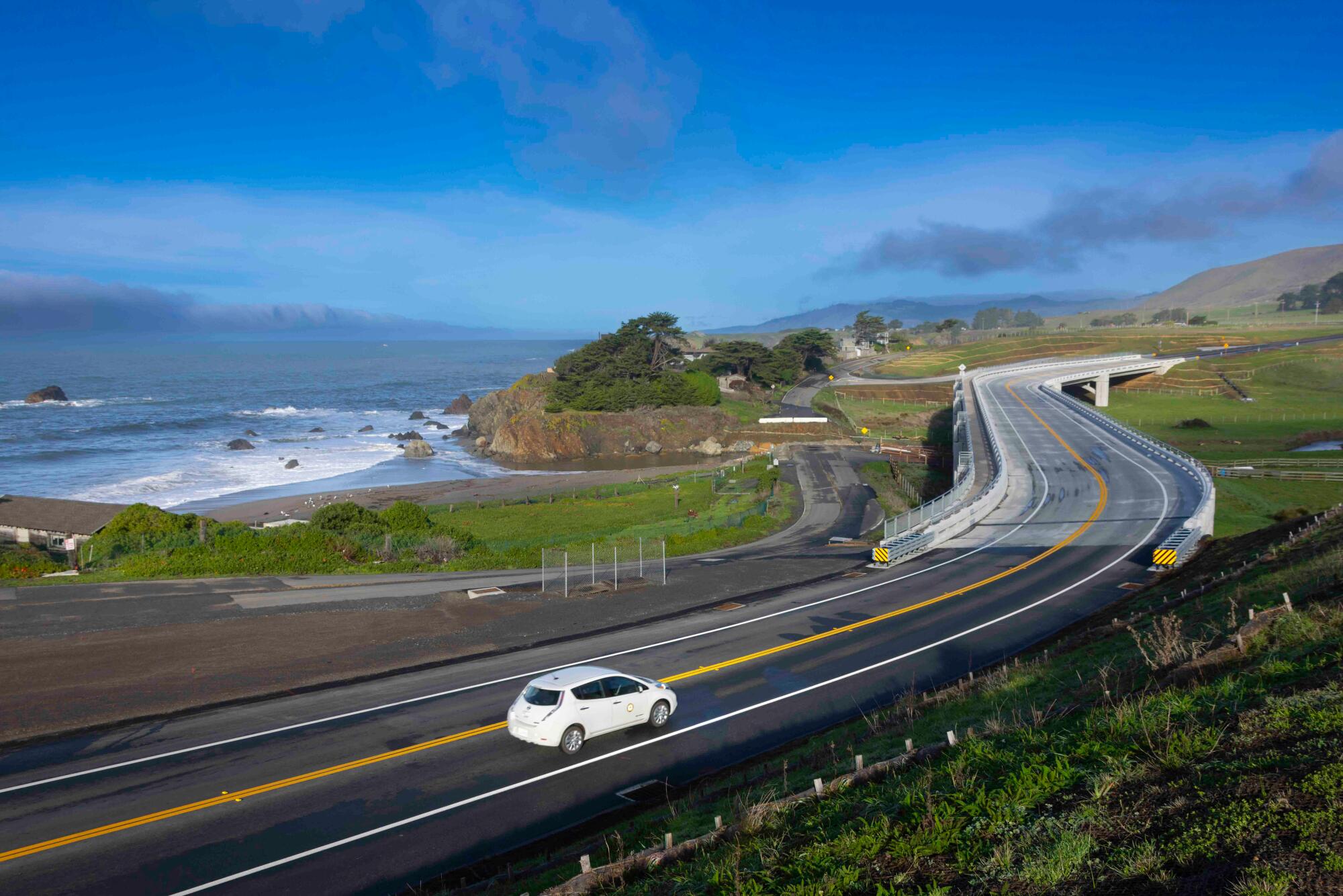
In what many described as a major coup in government bureaucracy, the California Department of Transportation (Caltrans), the coastal commission and county leaders set aside their differences to come up with a new solution together. By November 2020, they had hammered out a plan to relocate almost one mile of the highway — most notably with a new 850-foot-long bridge spanning Scotty Creek, a degraded stream that, choked for decades by the highway’s current configuration, rarely reached the ocean anymore. Rather than agonize over how to restore the landscape to some former, unobtainable baseline of “natural,” officials unanimously agreed that this bold re-imagining of the coast was the best way forward among no perfect options.
The concrete bridge (a monstrous overpass or a reasonable compromise, depending on who’s talking) will at least allow Scotty Creek to flow freely into the ocean again — making room for more red-legged frogs, Myrtle’s silverspot butterflies, and the passage of steelhead trout and coho salmon. Officials reasoned that elevating the highway would avoid paving over what’s left of the wetlands, which were already in desperate need of healing. By rerouting traffic onto a bridge, these drowning habitats would have the space to recover and migrate inland as the sea moved in.
State transportation officials also agreed, as part of the $73 million project, to pay $5 million to help clean up the mess of abandoned homes and failed road repairs. An additional $6.5 million will go toward wetland, creek and prairie restoration. Some of the old highway will be converted into a public coastal trail, and visitors will have access to a new parking area, as well as a beach that was once limited by private property.
Caltrans also set aside money to negotiate and acquire land from three private properties, including oceanfront portions of a historic ranch that will be most impacted by the realigned highway. Once completed, much of the open space will be transferred to Sonoma County to manage on behalf of the public.
This all came as a shock at first for Philip and Roberta Ballard, who own and live on the ranch, but they said they’ve come to understand the necessity of this project. The bridge still feels way too big — especially for this rural stretch of paradise that first captured their hearts more than two decades ago — but after years of meetings, questions and debating each trade-off, the retired couple decided to turn their energies toward making sure Scotty Creek got restored as part of the deal.
The creek, the largest watershed between Salmon Creek and the Russian River, has needed help since before they purchased the ranch, they said. In a past life, steelhead trout and coho salmon thrived in this stream. The once-abundant fish disappeared after the concrete culvert, installed in 1952 to support the highway, blocked their ability to migrate between fresh- and saltwater. The brackish habitat drowned over the decades. Then the creek, swollen after a series of big storms in the 1980s, flooded the lower plain. The stream banks were denuded of vegetation and the riffle crests obliterated as the choked stream tried to reach the sea.
Since 2004, the Ballards, both professors emeriti of pediatrics at UC San Francisco, have been piecing together ways to restore the creek, one small project at a time. Full restoration would require grading and reshaping the riverbanks, bringing back the native vegetation, improving water flow and re-creating the pools that once provided shelter to juvenile fish. The $6.5 million that Caltrans promised as part of the final deal will go a long way, they said, to nursing this entire ecosystem back to life.
“A lot of our efforts have gone into trying to make the best out of something that is necessary,” Roberta Ballard said. “We’ve arrived at feeling reasonably good about getting the best mitigation we can get for this region and getting something reasonably positive out of it.”
Construction crews work on building a new bridge over Scotty Creek, as part of Caltrans’ Gleason Beach Roadway Realignment Project.
(John Huseby / Caltrans)
When we don’t understand and don’t allow for the ocean’s ways, we end up with homes perched on crumbling cliffs and seawalls still making a stand. Guided by a few mere decades of history and a narrow understanding of the California shore, many today know only how to preserve the version of the coast they learned to love. Rather than imagine a different way to live, we cling to the fragility of what we still have and account for only what we consider lost. Even remembering how wide a beach used to be, or how the cliffs once withstood the tide, glorifies the notion that resilience is measured by our ability to remain unchanged.
We fail to see how we’ve replaced entire ecological systems with our own hardened habitats, and then altered the shoreline even more once the shore began to disappear. Neither replicating the past nor holding on to the present is going to get us to the future that we need. Learning from the recurring cycles of nature, listening to the knowledge gained with each flood and storm, adapting and choosing to transform — this is what it means to persevere. Change, in the end, has been the only constant in our battle for permanence. Change is the only way California will learn how to live with, not on, this beautiful, vanishing coastline that so many people settled and still wish to call home.
Stefan Galvez-Abadia, Caltrans’s district division chief of environmental planning and engineering, is now attempting with his team to design a prettier bridge at Gleason Beach, one more fitting for the rural landscape. They’ve studied the arched columns of Bixby Creek Bridge on the Big Sur coast and other popular landmarks that have become iconic over time. They’ve conducted surveys on what color to paint the bridge — some shade of gray or brown, for example, or a more distinct hue like that of the Golden Gate Bridge. Donne Brownsey, who served as vice chair of the Coastal Commission at the time, remarked that the project reminded her of a concrete beam bridge in Mendocino County that spans the mouth of the Ten Mile River, just north of where she lives in Fort Bragg. “It was a new bridge, it caused a lot of consternation, but I didn’t know that the first few times I went over it — I would look forward to that part of the drive, because I could see the whole estuary to the west, and I could see the rivershed to the east,” she said. “You don’t even really see the bridge anymore because the swallows now all nest there, and it’s just part of nature.”
The bridge at Gleason Beach, facing similar design constraints as the Ten Mile Bridge, also has to be massive — a counter-intuitive twist to what one might think it means to accommodate the environment. Engineers had at first tried more minimal options — a shorter bridge, thinner columns, a less intrusive height — but many were not large enough in size or distance to outlast the coastal erosion projected for the next 100 years. And to give the wetlands enough space to grow back, the highway needed to be elevated at a landscape-wide scale.
The completed bridge and realignment of Highway 1 can now be seen at Gleason Beach, about an hour north of San Francisco.
(Caltrans)
Despite so many years of seminars and talks about climate change adaptation, turning an abstract concept like managed retreat into reality has been a delicate exercise in compromise, Galvez-Abadia said. There were few case studies to turn to, and each one he examined dealt with an increasingly complicated set of trade-offs.
“You don’t have many choices when it comes to sea level rise,” he said, flipping through almost two dozen renderings his team had tried. “Whichever way you choose, you’re going to have some kind of impact. These are the difficult decisions that we will all have to make as a region, as a community, for generations to come.”
As he filed away his notes and prepared to break ground, he reflected once more on all the years it took to reach this first milestone. The process wasn’t easy. A lot of people are still frustrated. Even more are disappointed. Many tough property negotiations still lay ahead, but he hoped, at least, to see the wetlands and creek recover beneath the bridge one day. If the native plants reemerge, the salmon return, and there still remains a coast that families could safely access and enjoy, perhaps this new highway — however bold, however different — could show California that it is possible, that it isn’t absurd, to build toward a future where nature and modern human needs could finally coexist.
The exercise coincided with President Ferdinand Marcos’s departure for a five-day trip to India, where he said he would look to deepen maritime ties.
India and the Philippines have staged their first joint sail and naval exercises in the disputed South China Sea.
The two-day joint military deployment that kicked off on Sunday is likely to anger China, which claims nearly the entire key waterway and has separate territorial disputes with the two Asian countries.
Philippine Chief of Staff Romeo Brawner Jr said on Monday that the joint sail took place inside his country’s exclusive economic zone.
“We did not experience any untoward incidents, but there are still those shadowing us – as we had already expected,” Brawner told reporters, without naming China.
In past joint patrols with other foreign navies, Chinese navy and coastguard ships have kept watch from a distance, according to the Philippine military.
Indian navy ships that took part included guided missile destroyer INS Delhi, tanker INS Shakti and corvette INS Kiltan. The Philippines deployed two frigates, BRP Miguel Malvar and BRP Jose Rizal.
The exercise coincided with President Ferdinand Marcos’s departure for a five-day trip to India, where he said he would look to deepen maritime ties and seek cooperation on sectors including defence, pharmaceuticals and agriculture.
Brawner, meanwhile, expressed hope that Filipino forces could engage India’s military in more joint manoeuvres in the future.
The drill “sends a powerful signal of solidarity, strength in partnership and the energy of cooperation between two vibrant democracies in the Indo-Pacific”, he said.
China’s Ministry of Foreign Affairs said in a statement that territorial and maritime disputes should be resolved between the countries directly involved, and no third party should intervene.
In response to a question last week about the Philippines’ plans to build up military cooperation, the Chinese Ministry of National Defense called the country a “troublemaker” that has aligned itself with foreign forces to stir up trouble, in what China deems its own territorial waters.
“China never wavers in its resolve and will safeguard national territorial sovereignty and maritime rights and interests, and take resolute countermeasures against any provocations by the Philippine side,” spokesperson Zhang Xiaogang had told reporters.
The South China Sea is a strategic shipping route where $3 trillion of annual shipborne commerce takes place.
A 2016 ruling of an international arbitral tribunal found China’s sweeping claims have no basis under international law, a decision Beijing rejects.
Joint Sea-2025 exercises begin in waters near Russian port of Vladivostok and will last for three days, China’s Defence Ministry says.
China and Russia have begun joint naval drills in the Sea of Japan as they seek to reinforce their partnership and counterbalance what they see as a United States-led global order.
The Chinese and Russian governments have deepened their ties in recent years, with China providing an economic lifeline to Russia in the face of Western sanctions over Moscow’s invasion of Ukraine.
The Joint Sea-2025 exercises began in waters near the Russian port of Vladivostok and will last for three days, China’s Ministry of National Defence said in a statement on Sunday.
The two sides will hold “submarine rescue, joint anti-submarine, air defence and anti-missile operations, and maritime combat”.
Four Chinese vessels, including guided-missile destroyers Shaoxing and Urumqi, are participating in the exercises, alongside Russian ships, the ministry said.
After the drills, the two countries will conduct naval patrols in “relevant waters of the Pacific”.
Russian President Vladimir Putin, left, shakes hands with Chinese President Xi Jinping [File: Kenzaburo Fukuhara/Handout via Getty Images]
China and Russia have carried out annual drills for several years, with the “Joint Sea” exercises beginning in 2012.
Last year’s drills were held along China’s southern coast.
With this year’s drills in the Sea of Japan, in its annual report last month, Japan’s Ministry of Defence warned that China’s growing military cooperation with Russia poses serious security concerns.
“The exercise is defensive in nature and is not directed against other countries,” the Russian Navy Pacific Fleet said earlier this week, according to a report by the US Naval Institute’s online news and analysis portal.
On Friday, the Chinese Defence Ministry said this year’s exercises were aimed at “further deepening the comprehensive strategic partnership” of the two countries.
China has never denounced Russia’s more than three-year war nor called for it to withdraw its troops, and many of Ukraine’s allies, including the US, believe that Beijing has provided support to Moscow.
European leaders asked China last month to use its influence to pressure Russia to end the war, now in its fourth year, but there was no sign that Beijing would do so.
China, however, insists it is a neutral party, regularly calling for an end to the fighting while also accusing Western countries of prolonging the conflict by arming Ukraine.
Homes were hit in a Russian missile strike on Mykolaiv (pic: State Emergency Service of Ukraine)
A Russian missile strike has destroyed homes and civilian infrastructure in Ukraine’s southern city of Mykolaiv, local officials say.
At least three civilians were reported injured in the city near the Black Sea, which has been repeatedly shelled by Russian forces. Ukraine’s State Emergency Service posted photos of firefighters at the scene after the missile strike.
Early on Sunday a massive oil depot fire was raging near Russia’s Black Sea resort of Sochi – blamed by the Russian authorities on a Ukrainian drone attack. Sochi’s airport in the same area – Adler district – suspended flights.
Krasnodar Region Governor Veniamin Kondratyev said on Telegram that drone debris had hit a fuel tank, and 127 firefighters were tackling the blaze.
The drone attack was one of several launched by Ukraine over the weekend, targeting installations in the southern Russian cities of Ryazan, Penza and Voronezh. The governor of Voronezh said four people were injured in one drone strike.
Ukrainian President Volodymyr Zelensky called for stronger international sanctions on Russia this week after a deadly attack on Kyiv on Thursday killed at least 31 people.
More than 300 drones and eight cruise missiles were launched in the assault, Ukrainian officials said, making the attack one of the deadliest on the capital since Russia launched its full-scale invasion in February 2022.
Watch: Explosion rocks Russian oil facility in Novokuybyshevsk, Russia, on Saturday
SACRAMENTO — Voters’ approval Tuesday of an open primary system, combined with their 2008 decision to strip state lawmakers of the power to draw their own election districts, will reshape California politics. The question is: How?
Gov. Arnold Schwarzenegger, who backed both moves, is confident that state elections will become more daunting for the rigid partisans he says plague Sacramento. Other politicians and election strategists are not so sure.
The new system will put candidates of all political stripes on a single ballot, and all voters will be able to participate. The top two vote-getters in a given contest — regardless of political affiliation — will advance to the general election. Supporters say that once the system is in place and voting districts have been redrawn outside of the Legislature, candidates will have no choice but to move to the middle as they compete for voters who are more politically diverse.
“Coupled with redistricting, Proposition 14 will change the political landscape in California — finally giving voters the power to truly hold politicians accountable,” Schwarzenegger said after declaring victory late Tuesday. Proposition 14 passed with 54.2% of the vote.
But party leaders, as well as some political analysts and election experts — admittedly with a vested interest in the status quo — offer a number of reasons that Proposition 14 could do the opposite of what Schwarzenegger suggests.
They say it could push California back to the days when candidates were picked by party bosses in smoke-filled rooms and send the cost of campaigns sky-high, giving special interests more power and wealthy candidates more of an advantage. The new system could even further disenfranchise candidates who are trying to break free of the special interests that have a grip on government, they say.
“This is a process that lends itself to back-room dealing, to big decisions being made by small groups of people,” said California Republican Party Chairman Ron Nehring.
In cases where two strong Republicans are running against one another, he said, party leaders may pressure one of them out of the race to avoid any risk of splitting the vote and creating an opportunity for other candidates to advance.
“We’ll be forced to turn to nominating conventions,” Nehring said.
Under his scenario, instead of millions of registered Republicans choosing the GOP’s gubernatorial candidate, the task would fall to a relative handful of party loyalists.
Other opponents say the new system is possibly unconstitutional, and they are scrambling to assess their options to challenge it in court.
Elections expert Alan Clayton said open primaries will make some campaigns more costly. Currently, the winner of a partisan primary in a safely drawn district doesn’t face a big expense in the general election, Clayton said , and that scenario may no longer be possible in some districts.
A new emphasis on money could give an advantage to wealthy candidates and hurt minority contenders with more limited funds, said Clayton, who represented groups, including the Los Angeles County Chicano Employees Assn., in the redistricting process.
State Democratic Party Chairman John Burton said anything that requires more fundraising is not good for state politics: It “means there’s more money that will have to be raised, and that doesn’t come from little old ladies, that comes from special interests.”
The new process could also disenfranchise candidates from smaller political parties, so those groups are weighing a possible court challenge, said Cres Vellucci, a spokesman for the Green Party of California.
“We would not be on the November ballot in the top two, and that’s the election that counts,” Vellucci said. “People don’t vote in the primaries. They vote in the majors.”
An analysis by the nonpartisan Center for Governmental Studies concluded recently that more than a third of all state legislative and congressional races could produce runoffs between two members of the same party and that nearly all of those races would feature two Democrats.
The Los Angeles-based group said there may be some races in which a “top two, same party” general election contest could be close enough that voters from another party, or decline-to-state voters, could swing the election to the more moderate candidate.
Backers of the open primary measure said the current system promotes partisan bickering that caused last year’s state budget to be delayed by weeks, forcing officials to stop cash payments to vendors and issue IOUs.
“For too long, running for office in California has meant pandering to your party’s narrow base, and it’s just to win that primary, and then you are basically a shoo-in,” said Jeannine English, state leader with AARP. The result, she said, is “elected officials who are locked into inflexible ideological positions that make it impossible for them to work together for solutions to get California back on track.”
But, there is some skepticism among political scientists, including Jaime Regalado, executive director of the Edmund G. “Pat” Brown Institute of Public Affairs at Cal State L.A.
“I don’t think Proposition 14 is going to make a fundamental difference in candidates elected and whether there will be a less polarized Sacramento,” said Regalado, who foresees unions and political parties continuing to elect their favorites. But the effect could be magnified when combined with the change in redistricting.
Two years ago, state voters gave the job of drawing legislative districts to a panel of citizens: five Democrats, five Republicans and four members of neither main party. That panel is to be picked by year’s end.
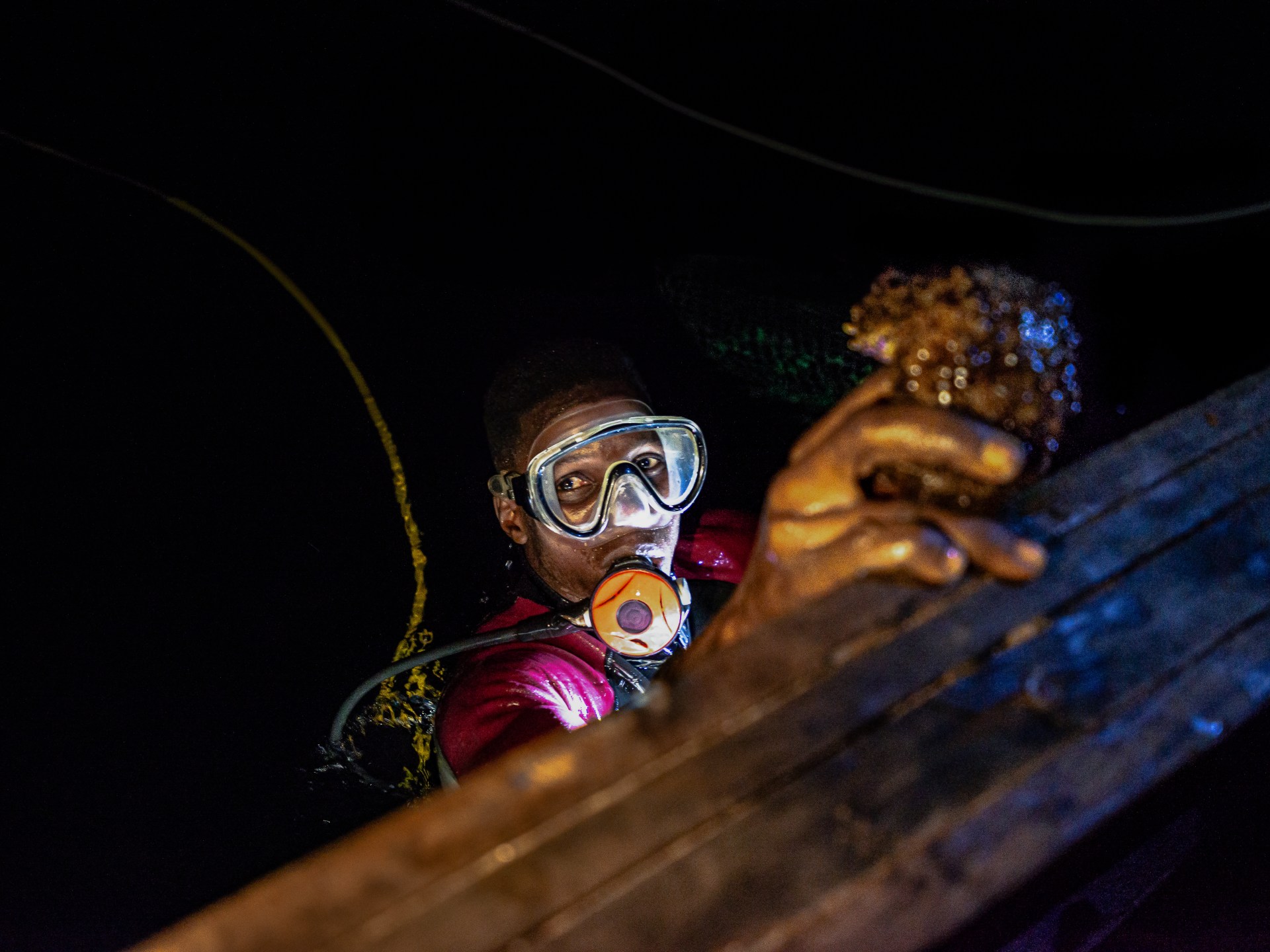
Banana Islands, Sierra Leone – As the sun dips below the horizon, Emmanuel Pratt tugs a worn cord and the outboard engine sputters to life. His wooden canoe, painted in white and faded blue, cuts through the darkening waters. Fruit bats screech overhead.
Pratt, 35, is a seasoned sea cucumber diver from the Banana Islands – an archipelago home to about 500 people in Sierra Leone. For 15 years, he has made a living scouring the ocean floor for these creatures that resemble warty, oversized sea slugs. They hide in the silt by day and emerge at night to inch across the ocean floor, gobbling up decomposing matter.
Also on the canoe, 25-year-old Omolade Jones – sweating in a half-zipped-up wetsuit – perches on the edge of the boat and gazes out at the dark water.
After 10 minutes, the younger diver gestures at Pratt to cut the engine and readies himself to dive. Jones blows on his mask, grabs an underwater torch and wraps a breathing hose around his waist.
The seabed surrounding the small, jungle-coated archipelago used to teem with sea cucumbers. Nowadays, they are scarce and scattered. Freediving is no longer an option. Pratt and Jones have to dive deeper, for longer, to find their catch.
They have turned to “hookah diving” – a makeshift system where air is pumped from a diesel-powered generator on the boat down through a plastic hose. It is a risky and fragile lifeline. The engines are often old and the air is easily contaminated by diesel fumes. And experts say it is much more dangerous than scuba or free diving.
As the diesel engine that powers his air supply rattles in the boat, Jones quietly slips over the edge into the black water. The yellow hose trails behind him as he swims away from the canoe. Minutes later, his torch lights up a column of water above the seabed.
Pratt sits in the canoe, a cigarette dangling from his lips, his eyes fixed on the spot where Jones’s light is. “The cucumbers are running out,” he says glumly.
While they used to haul in dozens of buckets of sea cucumbers a night, now they struggle to find a handful. Pratt says the divers rarely make more than $40 on a dive – barely enough to cover the costs of fuel or to hire some of the diving equipment.
Not long after Jones exits the boat, he flashes his torch to signal that he is ready to swim back in. When he reaches the canoe, he hoists himself up on the side with his forearms. In one hand, he holds the torch, in the other, a small, brown sea cucumber.
Pratt takes his turn and disappears into the dark water. He surfaces a while later with a sea cucumber. But the divers are unimpressed. After a couple of hours at sea, they head back to the mooring with a meagre catch of just three specimens.
Overhead, the almost-full moon casts a white sheen over the water and dimly illuminates the way home.
Video shows people jumping into the sea as fire engulfs a passenger ship, the KM Barcelona VA, in Indonesia. The national search and rescue agency has begun evacuating the burning vessel near Talise Island, in North Sulawesi Province.
By Jennifer Givhan Mulholland Books: 384 pages, $29 If you buy books linked on our site, The Times may earn a commission from Bookshop.org, whose fees support independent bookstores.
An early line from “Salt Bones,” the latest novel from talented poet and novelist Jennifer Givhan, reads, “Daughters disappear here.”
It is a line that haunts the Salton Sea region, where Givhan has set her latest novel and infuses the toxic air upon which her characters must survive. In other words, this warning to keep your daughters close clings to everything. It is in the air, but also — in this thriller that employs elements of magical realism and mystery — it is in the water, buffeting each of these characters with the cadence of windblown waves crashing against the shore.
The Salton Sea is just as much a character here as Givhan’s main protagonists: Mal, a mother of two daughters, and the two daughters themselves — Amaranta, in high school, and Griselda, a science major in college. Through them, we get a sense of this place, what it was, what it is and what it is becoming. A sea that evaporates and pulls back year after year, exposing a lake bed contaminated with agricultural runoff and revealing not just the bones of fish but also a painful history that many would rather remains beneath the water’s surface.
“Salt Bones” by Jennifer Givhan
(Mulholland Books)
El Valle, the fictional town that serves as the primary setting for “Salt Bones,” is haunted by what surrounds it. By the memories of the missing. Daughters like Mal’s own sister, Elena, who disappeared more than 20 years before.
Now with two daughters of her own, Mal is a butcher at the local carnicería. But when one of the workers at the shop, Renata, a young woman the same age as Mal’s eldest daughter, doesn’t show up for work one day, Mal begins to spiral into the past, questioning what she could have done differently, and then what she could do now. And, most of all, why does all of this seem to keep happening here in El Valle?
For Mal and her family, there is no escape. They are followed not just by memories, but also by Mal’s mother’s spite-fueled dementia, which returns all of them again and again to the fissures in time just before and just after the disappearance of Mal’s sister. And now, with Renata gone missing, there is nowhere to hide from the tragedy of this place, not at work, not at home and not even at the edges of the Salton Sea where Mal can sometimes find a tenuous peace.
But it is not just Mal who roams these shores, but La Siguanaba, a shape-shifter often associated with Central American and Mexican folklore, wearing “whatever a man lusts after most. Sequins. Spandex. Fishnet. Nothing at all.” And then after enticing these men to approach, this being — often described as a woman — turns and reveals the “white-boned skull of a horse” beneath her long dark hair.
“By the time they scream,” Givhan writes, “it’s too late.”
La Siguanaba is a cautionary tale and a myth to some in El Valle. She is a ghost story to keep the kids safe and away from danger, but to Mal, she is very real. La Siguanaba comes to her in dreams; in her waking hours, she lurks just beyond the light. Her smell — something like urine and unmucked stables — floats on the wind, acting like a warning, a memory, a message.
But all this — the monster in the shadows, the missing daughters and even a rising tension in El Valle over a lithium plant and a looming ecological disaster — is only part of the story. Mal can only know so much, and it is through the details revealed by Mal’s daughters, Amaranta and Griselda, that we begin to comprehend the depth of this story.
Like all good mysteries, there is a whole world just out of reach: secret lives, secrets kept, secrets used like currency. For us — the readers — the clues are there. Givhan does a wonderful job infusing the early pages with hints and observations from each of the three perspectives, Mal, Amaranta and Griselda, all of whom are hiding things from each other.
To the reader, who benefits from the combined knowledge of these characters, each perspective adds a different lens. Mal, with her mother’s intuition and almost otherworldly connection to La Siguanaba, Amaranta, who is the youngest and still very much a child and who sees what others don’t expect her to, and then Griselda, home from college, who looks on all of this with a fresh, almost outside perspective. All of them come to the same conclusion very early on: Something is very off in this small community.
“Salt Bones” is a worthy read. It’s a book infused with the language and culture of a strong Mexican American and Indigenous community. In some way, like La Siguanaba, it’s a conduit into another world. A complicated, real and very much welcome, if a bit scary, world.
And though the layering of information — of what we know, what remains hidden from us and what has been foreshadowed — does add up (delaying what becomes a propulsive search for the missing in the second half of the novel), Givhan’s talents as a writer of blunt, strong sentences and remarkable poetic passages regarding the landscape and the sea more than make up for any delay.
“Salt Bones” is a triumph. One of the most masterful marriages of horror, mystery, thriller and literary writing that I’ve read in some time. And it is certainly a book that will haunt you (in a good way!) for a very long time after you’ve turned the final page.
Waite is the author of four novels and a book critic for the San Francisco Chronicle.
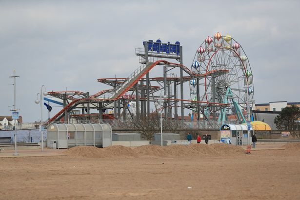
Despite its marmite reputation, a ‘rundown’ seaside town once dubbed the country’s worst has been featured in The Times’ league tables for the best UK beaches in 2025
An unexpected seaside town has been featured in The Time’s best 50 UK beaches in 2025 list(Image: Getty Images)
A ‘rundown’ seaside town has surprisingly made the league tables for the best UK beaches in 2025 – despite its crumbling reputation.
Every year, around four million holidaymakers flock to Skegness, lured in by rows of flashing arcades, stomach-churning funfair rides, and a constantly lively beach. It’s long been one of the most iconic coastal resorts on the Lincolnshire coast, but has been stung with a barrage of complaints from locals and tourists alike – and was once even ranked alongside North Korea and Syria as one of the worst places in the world to visit.
Skegness recently came 16th-to-last in Which?’s annual league tables of the best UK seaside resorts – scoring a not-so-great 54 per cent overall destination score*. Travellers rated the town a respectable three stars for its beach, seafront/ pier, tourist attractions, parking availability and food and drink offerings – but gave just two stars for its shopping scene and one star for its scenery and peacefulness.
Skegness attracts millions of tourists every single year, despite its questionable reputation(Image: PA)
It’s a slight improvement from years gone by – but prove that Skegness’ £20 million plan to transform the area is still urgently needed. In 2023, Skegness came in at the absolute bottom on Which?’s ranking, and scored 5th last in 2024. Back then, one reviewer described the beach as ‘horrible’, arguing they had to trek 30 miles up the road to Mablethorpe instead. “Overall, it’s a terrible place with terrible people,” they said. “I will never go there again.”
Another agreed, branding the town the ‘dirtiest place in England’. “The sea has a brown froth on the top,” they fumed. “The streets are dirty [and] the roads are potholed.” Despite the heavy criticism, it’s clear Skegness boasts an unwavering popularity, and still attracts swathes of positive reviews online.
Skegness has become the marmite of UK seaside towns(Image: Anna Draper/ Lincolnshire Echo)
“It’s a nice old-fashioned beach experience that brought back many childhood memories,” one person hailed. “The beach itself is clean and well-maintained and there are lots of attractions around to keep kids and adults amused.” Another recent traveller said they were ‘pleasantly surprised’ by how well-maintained the area is. “The beach and town look clean and well looked after,” they wrote.
Much of Skegness’ hate can sometimes feel unfair. It’s not the place to go if you want to sip on iced oat milk matcha while chewing on £5 sourdough with poached eggs. But, if you’re looking for that classic UK seaside experience, it has your back. In fact, The Times recently featured Skegness in its best 50 UK beaches in 2025 list – hailing the town for offering ‘all round entertainment’.
The beach was ranked one of the best in the UK(Image: PA)
“Having spent 17 years watching the crumbling of our traditional seaside resorts, I’d argue that Skeggy is the new King of seaside tat,” the publication wrote. “There are donkeys, rollercoasters, wall-to-wall chippies, arcades, a pier and the Embassy Theatre, offering much more than the tide of tribute acts that flood other seaside playhouses. As for the beach, it’s big, soft and golden, with views across the Wash to the Norfolk coast.”
Earlier this year, Skegness was selected to receive a whopping £20 million of funding and support over the next ten years as part of the government’s Plan for Neighbourhoods. This scheme focuses on three goals: thriving places, stronger communities, and taking back control – and allows local authorities to drive forward their own priorities.
Paul McCooey, Chair, Connected Coast’s Skegness Sub-Group said: “We have been awaiting further steer on this funding and now that the details have been announced, we can get to work with our communities, partners, and stakeholders to shape a plan for investment. In Skegness, we have already seen what can be achieved through partnership working through the Town Deal projects, as exemplified by projects such as the Skegness Learning Campus which is set to be an economic game changer for our area. Now, we can bring even more improvements to the town to benefit more people long into the future.”
*Which?’s results are based on an online survey of 8,952 experiences from 3,872 Which? Connect panel members conducted between January and March, 2025.
Do you think Skegness deserves the criticism it receives? Let us know in the comments section below
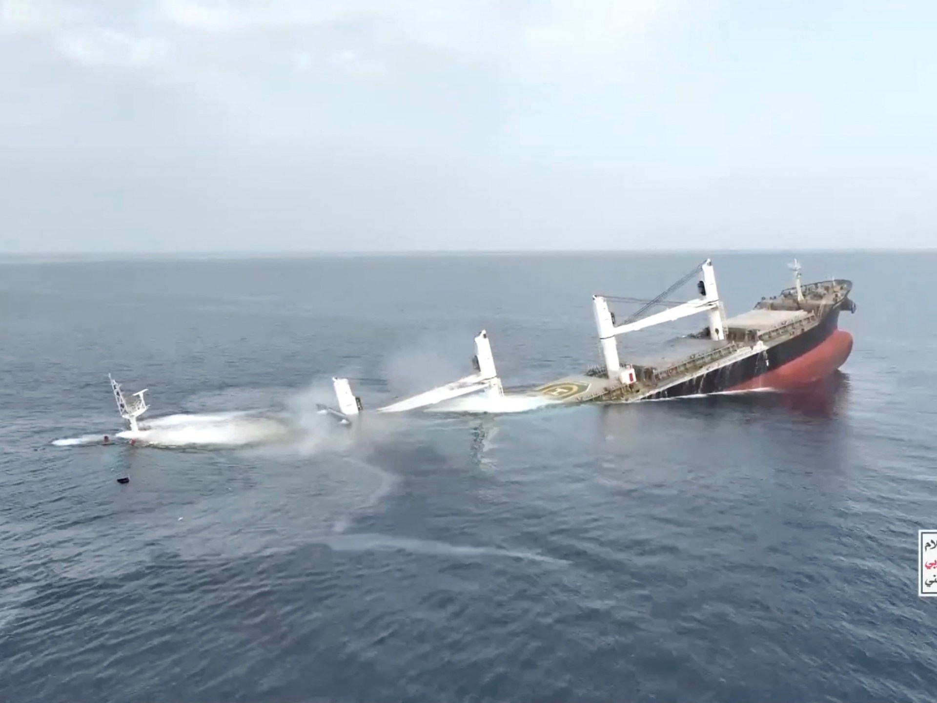
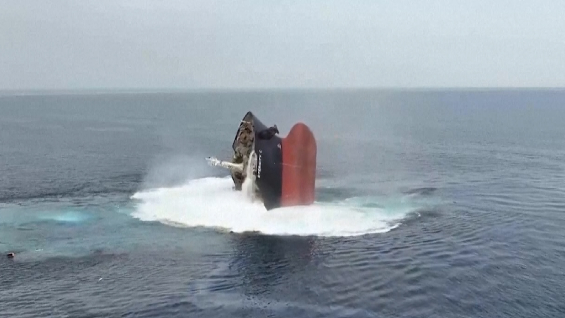
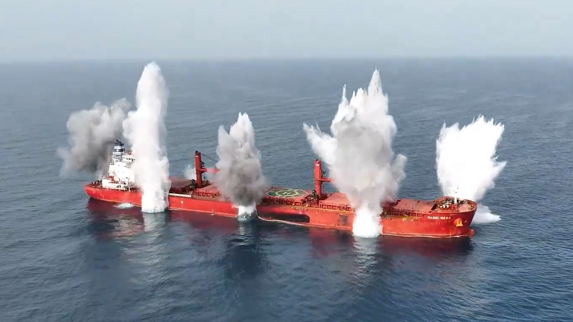
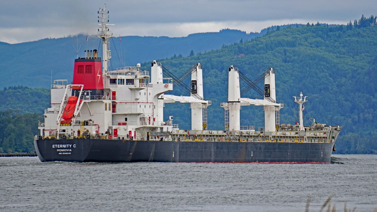
Four sailors from Eternity C dead, 10 found alive, 11 still missing – six believed to be in Houthi hands.
Houthi rebels in Yemen attempted to strike Israel’s Ben Gurion airport after sinking two vessels in the Red Sea this week, as the group ramps up its military pressure in support of Palestinians under Israeli fire in its bid to bring the war in Gaza to an end.
Houthi military spokesman Yahya Saree said on Thursday that the group had carried out a “qualitative military operation” with a ballistic missile after the Israeli military reported the strike had been intercepted.
Meanwhile, maritime security sources told the Reuters news agency that the Houthis were holding six crew members from the Greek-operated, Liberia-flagged Eternity C vessel, which the rebel group attacked on Monday, killing at least four sailors.
A total of 25 people were on board the Eternity C, according to Aspides, the European Union’s naval task force patrolling the Red Sea. Ten crew members were reportedly pulled out of the sea alive after the vessel sank on Tuesday, while 11 are still missing – with six believed to be in Houthi hands.
Saree said on Wednesday that the Houthis had “moved to rescue a number of the ship’s crew, provide them with medical care and transport them to a safe location”.
The United States embassy in Yemen countered that on X, accusing the rebels of kidnapping the crew members after “killing their shipmates, sinking their ship and hampering rescue efforts”.
The attack on the Eternity C came one day after the Houthis struck and sunk the Magic Seas, reviving a campaign launched in November 2023 that has seen more than 100 ships attacked. All the crew from the Magic Seas were rescued.
After Sunday’s attack, the Houthis declared that ships owned by companies with ties to Israel were a “legitimate target” and pledged to “prevent Israeli navigation in the Red and Arabian Seas … until the aggression against Gaza stops and the blockade is lifted”.
Late on Sunday, Israel’s military attacked Yemen, bombing the ports of Hodeidah, Ras Isa and as-Salif, as well as the Ras Qantib power plant on the coast. The Houthis had fired missiles towards Israeli territory in retaliation.
Israel said its attacks also hit a ship, the Galaxy Leader, which was seized by the Houthis in late 2023 and held in Ras Isa port.
The Houthis held 25 crew members from the Galaxy for 430 days before releasing them in January this year.
Yemen’s Houthis have released video of a second attack within days that ended with a commercial ship sinking in the Red Sea. At least four crew members from the Eternity C were killed and 15 others are missing.
Yemen’s Houthis have released a video showing their attack on the Magic Seas, a commercial ship they said had sunk in the Red Sea. The group says it’s targeting vessels linked to Israel in support of Palestinians in Gaza.
Surge in Red Sea attacks after months of calm potentially signals revival of Houthis’ campaign over Gaza war.
Five crew members have been rescued from a Liberian-flagged cargo ship in the Red Sea after a suspected attack from Yemen’s Houthi group, according to a maritime monitor. The attack is so far known to have killed at least three sailors out of the 22-member crew and wounded two.
The United Kingdom Maritime Trade Operations centre (UKMTO), run by the British military, said on Wednesday that “search and rescue operations commenced overnight” after Monday’s attack on the Greek-owned Eternity C.
UKMTO had said on Tuesday that the ship sustained “significant damage” and “lost all propulsion”. UK-based security firm Ambrey told the AFP news agency that the badly damaged vessel had sunk off Yemen’s port city of Hodeidah, which is under the control of the Houthis.
The Houthis, who say they are targeting Israel-linked ships as part of a campaign of solidarity with Palestinians under relentless Israeli fire, to pressure the Israeli military to end its assault on Gaza, have not claimed responsibility for the attack.
However, it came one day after they claimed responsibility for attacking another cargo ship – the Magic Seas – in the Red Sea, causing it to sink. All the crew were rescued.
The assaults mark the first attacks on shipping in the Red Sea since late 2024, potentially signalling the start of a new armed campaign threatening the waterway, which had begun to see more traffic in recent weeks.
After Sunday’s attack on the Magic Seas, the Houthis declared that ships owned by companies with ties to Israel were a “legitimate target”, pledging to “prevent Israeli navigation in the Red and Arabian Seas … until the aggression against Gaza stops and the blockade is lifted”.
Yemen’s exiled government, the European Union’s Operation Aspides military force and the US State Department blamed the rebels for the attack on Eternity C.
“These attacks demonstrate the ongoing threat that Iran-backed Houthi rebels pose to freedom of navigation and to regional economic and maritime security,” State Department spokesperson Tammy Bruce said.
“The United States has been clear: We will continue to take necessary action to protect freedom of navigation and commercial shipping from Houthi terrorist attacks,” she added.
The bulk carrier had been heading north towards the Suez Canal when it came under fire by men in small boats and by bomb-carrying drones on Monday night, with security guards on board firing their weapons, according to Operation Aspides and Ambrey, cited by The Associated Press news agency.
Operation Aspides told AFP on Tuesday that three people had been killed, with at least two injured, including “a Russian electrician who lost a leg”.
Authorities in the Philippines told AFP that there were 22 crew on the Eternity C, all but one of them Filipinos.
The Eternity C’s operator, Cosmoship Management, has not commented on casualties or injuries.
In separate incidents, Israel’s military and the Houthis exchanged strikes on Sunday, with Israel saying it had bombed three ports and a power plant in Houthi-controlled areas of Yemen, prompting the Iran-allied group to fire more missiles towards Israeli territory.
Israel said it struck the ports of Hodeidah, Ras Isa and as-Salif on the Red Sea coast as well as the Ras Kathib power plant.
It said it also struck a radar system on the Galaxy Leader, which was seized by the Houthis and remains docked in the port of Hodeidah.