Explore Northeast L.A. via this 23-mile urban hiking trail
I was trying to discern whether I’d made a wrong turn when I heard a loud whoosh next to me. Somehow, I’d missed the red-tailed hawk perched on a small tree, watching me from an arm’s length away.
That was one of many delightful surprises I encountered as I developed a 6.7-mile urban hike that I will share in this edition of The Wild, our weekly outdoors newsletter.
Back in May, I published a 13.5-mile urban hike (see map) that connects trails along the Arroyo Seco and in Elephant Hill Open Space, Ascot Hills, Lincoln Park, Flat Top Park and Ernest E. Debs Park. I wanted to celebrate our local hillsides but also showcase natural areas that remain under threat of development.
I have wanted to expand the route ever since I published it. I got motivated, though, when I saw that the Mountains Recreation and Conservation Authority, or MRCA, will receive a $200,000 grant in Proposition 4 money to develop a trail connecting open spaces in Northeast L.A.
MRCA will consider how to connect Elephant Hill Open Space with other land that it owns and manages, including Elyria Canyon and Rainbow Canyon, along with parks and open spaces owned by other public agencies.

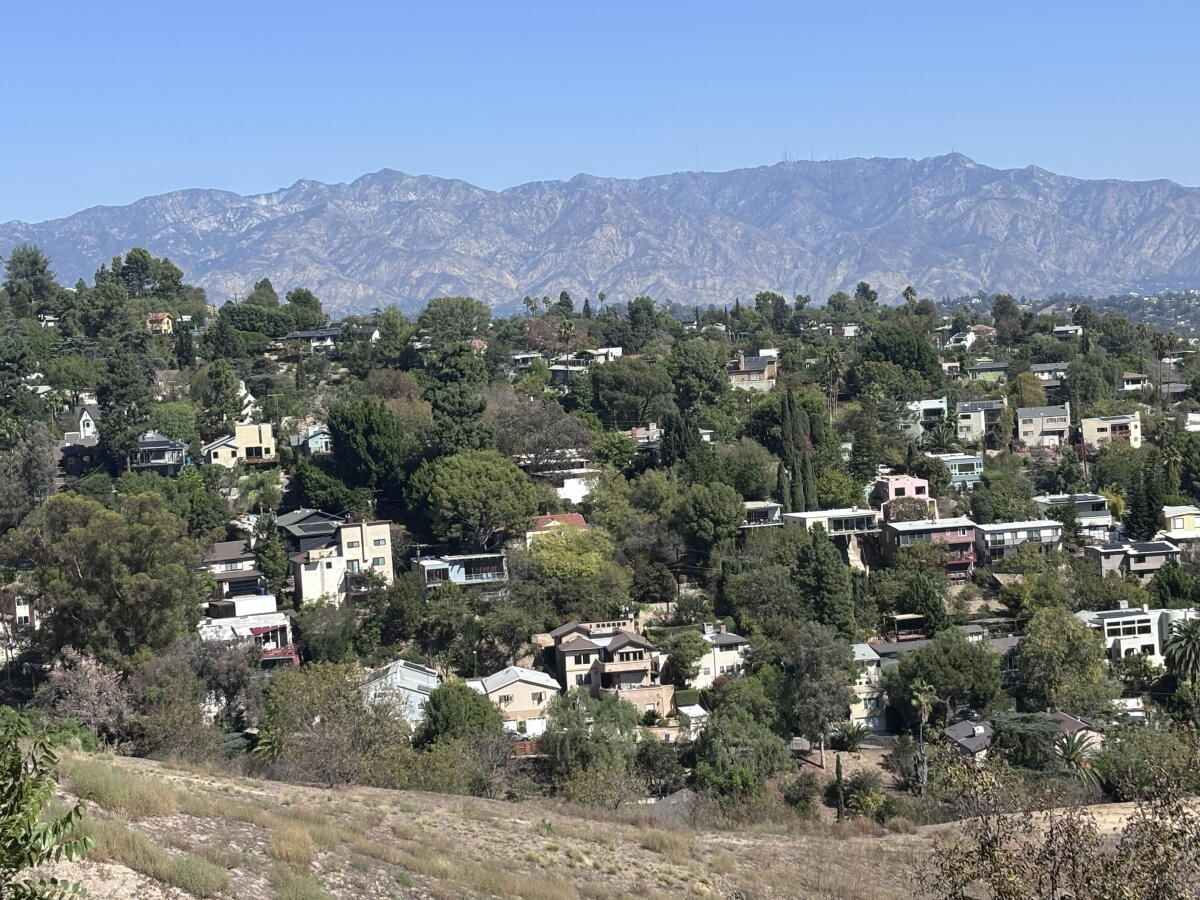
The view from Kite Hill, a high point in Mount Washington, from near North Avenue 37.
(Jaclyn Cosgrove / Los Angeles Times)
“We’ve been thinking about connectivity in Northeast L.A. for a while, the idea being that we connect the protected hilltops and canyons creating access to the Arroyo Seco, which ties up to the Angeles National Forest and down to the L.A. River,” said Sarah Kevorkian, deputy chief of wildfire resilience at MRCA, noting that there’s great energy and momentum built by community members who want to see their neighborhood open spaces protected.
I am eager to see what MRCA and its partners develop. Based on what I’ve experienced, urban hiking trails can lead to better connection among neighbors and a deeper appreciation for nature nearest to us. In the interim, I developed the trail below that envisions what a regional connector trail could look like.
The total extension to the River to the Hilltops route is about 9.4 miles when you include the three “connector” trails that I indicate via a dotted blue line on the map. In total, the full route is now about 23 miles. Below, I explain the heart of the extension through Cypress Park and Mount Washington, which is about 6.7 miles without the connectors, including the two that would take you to the larger original trail. I made this route in a “Choose Your Own Adventure” style, hoping to inspire folks to (legally!) explore their city, hence the flexibility (and complications in explaining mileage).
Some quick logistics before I dive into the route:
- I developed the route using CalTopo, an online mapping software with a desktop site and mobile app. You can download the CalTopo app onto your phone and follow the route there; you can also download the trail from CalTopo to use on your Garmin or other device. I also uploaded it to my AllTrails profile.
- In May, I dubbed the original trail “River to the Hilltops” in CalTopo and on AllTrails. Afterward, a reader suggested “Jewel Necklace” as a name. What do you think?
- I haven’t marked everywhere you can find a restroom or water, but will try to add those as time allows. Please plan accordingly, as some stretches run through neighborhoods or open spaces where there isn’t much nearby.
- There is no single place to start this route, although this newsletter will focus on the latest extension. You can start and stop this route in several spots though.
- Trail access and conditions can change. Please follow all posted signage (and contact me if you encounter major issues).
- This route travels through several neighborhoods. Please refrain from using Bluetooth speakers and anything else that would be disruptive to residents.
- There are several places along the route where you will walk in the street of a neighborhood because it lacks sidewalks; please use caution!
- At several junctures along the suggested route, you will have an option to take a different path that will essentially get you to the same place. Do what’s best for you, and most important: Have fun, be safe and don’t trespass!

A red-tailed hawk flies over Bob Scholfield Park in Mount Washington.
(Jaclyn Cosgrove / Los Angeles Times)
Now let’s talk more about the route (full map here).
To begin this extension into the neighborhoods of Mount Washington and, briefly, Cypress Park, I started at the Lincoln/Cypress Metro station off the A Line (previously, and forever in our hearts, the Gold Line). The station has a series of stairs and ramps that you can take down to West Avenue 26, which borders the station on its eastern-ish side.
You’ll quickly turn right (or northeast) onto Lacy Street, passing Lacy Street Neighborhood Park. I chose this option because, as you’ll see after about a quarter of a mile on Lacy, it leads to a pedestrian bridge.

A pedestrian path that leads to a bridge taking walkers and hikers over the 110 Freeway.
(Jaclyn Cosgrove / Los Angeles Times)
It is not a well-marked or particularly welcoming pedestrian bridge, but it exists nonetheless. You’ll see a narrow walkway lined with a green metal fence topped with spikes and, later, razor wire. Did I mention it’s not terribly welcoming?
Head over the 110 Freeway via this bridge, and turn right onto Arroyo Seco Avenue and then soon left on Amabel Street. But appreciate this little jaunt, as it’s the last bit of flat walking for a bit.

A pedestrian bridge over the 110 Freeway near Cypress Park.
(Jaclyn Cosgrove / Los Angeles Times)
Cross over North Figueroa Street, and trudge up the hill before you, which has an average grade of about 15%. You’ll pass a neighborhood sign for Mount Washington as you bear left on Isabel Street before making a quick right (north) turn onto Glenalbyn Drive. Continue northeast onto Beech Street and feel as amazed as I was when it becomes a dirt path.
As I trotted through here, I enjoyed watching a kettle of turkey vultures soaring high above the homes perched on the hillside, looking for a fine carrion brunch.
Rather than continuing on the dirt path that heads southeast, I headed up Montalvo Street. Be careful here, as there is no sidewalk. I headed north onto Andalusia Street, or Avenue on some maps, and then further northwest onto West Avenue 37.

A gate was installed on West Avenue 37 in the late 1980s to block rowdy visitors from driving to and partying on Kite Hill in Mount Washington. The route remains open to pedestrians.
You’ll soon arrive at Kite Hill, which The Times described in 1988 as “a scenic Mt. Washington location popular with kite-flyers by day and partying teenagers by night.”
The rambunctious youths were so noisy, L.A. City Council spent $1,200 — about $3,500 in today’s money — to install gates to prevent vehicle traffic. The route remains open to pedestrians.
“It’s like the Hollywood Bowl up there, but it goes on all night,” resident Bob Cummings, a real estate agent who had lived on Mount Washington for 18 years, told The Times in 1988. “It’s like a cancer that started. We’re asking for the city’s surgeons to cut it out.”
When I visited Monday, I saw no evidence of kites or parties, but I did appreciate the glorious views of our local hillsides and San Gabriel Mountains.

One perk of walking the Mount Washington leg of the route is the Halloween decor you’ll spy along the way.
(Jaclyn Cosgrove / Los Angeles Times)
At the juncture of West Avenue 37 and San Rafael Avenue, you have two options in terms of the route I’ve charted out: You can continue northwest on West Avenue 37, where you’ll quickly be frolicking in Elyria Canyon, or you can take San Rafael Avenue and a short winding path down to Rainbow Canyon, which is also lovely.
Although I designed this leg of the River to the Hilltops route to start at the Lincoln/Cypress Metro stop and end at the Southwest Museum Metro station, you can also turn it into a loop, as you’ll see on the map.
For the purposes of this newsletter, I’m going to explain the route via the first option, continuing northwest on West Avenue 37 and then right (or northwest) onto Killarney Avenue for about 400 feet until you turn right onto some wooden, dirt-covered steps. You’ve reached Elyria Canyon Park!

Wooden stairs lead down into Elyria Canyon Park, where hikers will find several species of native shrubs and trees.
(Jaclyn Cosgrove / Los Angeles Times)
Be mindful as you take the steps, as the loose dirt can be slippery. You will have lovely views of L.A. and its landscapes as you meander past native shrubs and trees, including black sage, toyon and wild cucumber. This 35-acre park “boasts one of the finest examples of California black walnut woodland in Southern California,” according to the Mountains Recreation and Conservation Authority, which manages the land.
That’s one reason that a 1996 Times story dubbed this park “a living example of the Los Angeles of 200 years ago.”
There are multiple routes, and I won’t discourage you from exploring beyond what I’ve mapped out, which from the map, you can see is a quick loop, passing through the park (including Akuutet Learning Nursery and the surrounding neighborhood. If you find yourself needing a snack break, you’re in luck. (I will admit that I wanted the same while in Elyria Canyon and took a short walk over to Little Barn Coffee House, one of my favorite spots in L.A.)

The path through Elyria Canyon travels through the 35-acre park that features a California black walnut woodland.
(Jaclyn Cosgrove / Los Angeles Times)
After the loop, you’ll head out of the canyon onto Elyria Drive and then make a left back onto San Rafael Avenue, which you’ll take for about a third of a mile. Continue north past San Rafael Avenue and Danforth Drive onto Sea View Avenue. In about a third of a mile, Sea View will transform into a dirt path as you enter Bob Scholfield Park (per the name etched into a rock under a tree).
Two red-tailed hawks flew overhead as I entered this charming stretch of the walk. I chatted with another hiker and petted his Great Pyrenees dog, as I grew up with the breed and have a soft spot for these giant fluffy goobers.
After following this dirt path as it curves around, you will return to a paved Sea View Drive. Head southeast, and you’ll quickly find yourself at Moon Canyon Park.

Moon Canyon Park in L.A.
(Jaclyn Cosgrove / Los Angeles Times)
Developers had wanted to construct 18 homes and a parking lot in this 4.5-acre canyon, but the L.A. City Council instead set aside $550,000 to preserve it, according to a 2003 Times story.
“I couldn’t be happier because the canyon will be left open,” resident Sharon Roesler, a member of a group opposing developing the canyon, said at the time. “We don’t have enough of these places to go to in Los Angeles.” (If you want to learn more about restoration efforts here, you can visit the Friends of Moon Canyon website, which is working to restore the canyon.)
You will walk southeast down a pleasant dirt path through the canyon, noticing those restoration efforts, before you hit pavement for just a moment and then immediately bear right onto West Pheasant Drive, another dirt path.

A Chevy van parked ahead on the trail.
(Jaclyn Cosgrove / Los Angeles Times)
I was enjoying my hike when I followed the bend of West Pheasant Drive and noticed a van parked ahead. Now, I’ve seen enough horror movies that I quickly started to write the opening scene to my demise.
EXT. DIRT HIKING TRAIL
“JAC, a well-meaning but unfortunately oblivious hiker, spots a vintage camper van on the trail. They have no idea what lurks ahead.”
Thankfully, there was nothing other than a funky DIY project lurking in the distance. I approached the van to find a cardboard sign attached (which, again, sounds creepier than it was).
“The process is as WiLD as the circumstances!” it read. “This van is unable to leave the road (you may have noticed 🙂 ) so we are resituating it to optimize space (something special, incoming!).”

A narrow dirt path called West Pheasant Drive on some maps.
(Jaclyn Cosgrove / Los Angeles Times)
After you pass the van art project, you’ll soon reach a nest of streets, as each has a bird name. You will turn right from West Pheasant onto Quail Drive and then quickly left onto Dove Drive. Follow Dove Drive southeast and quickly take a hard right (northwest) onto Glenalbyn Drive, followed by a hard left (southeast) onto Mavis Drive and then soon a right on Frontenac Avenue, then left on West Avenue 46 to head into the park area around the Carlin G. Smith Recreation Center.
You’ll pass through a gate and meander down the path, with an optional side quest to have a friend push you on the tire swing. After shenanigans, walk through the basketball court to where the path continues in the court’s southeast corner.
This route, when I traversed it, was loose and narrow. If it feels too sketchy, take the road or use a trekking pole if you’ve brought one. No reason to turn an ankle after you’ve had an otherwise splendid day!
At the end of this rustic route, take West Avenue 45 down to the Rainbow Canyon Test Plot, a publicly owned area where volunteers are readily restoring the canyon with native plants and shrubs. There is a pleasant little trail from the test plot that goes through the canyon. You will take it up to West Avenue 44.

A previous walker left a message on a utility pole to remind us of one reason we hike.
(Jaclyn Cosgrove / Los Angeles Times)
From here, you can either use the connector trail I’ve mapped out or head down West Avenue 44 to Marmion Way and the Southwest Museum Metro stop.
That is the end of the Mount Washington trail extension, but doesn’t have to be the end of your day. If you’re feeling adventurous, I have mapped out a connector route through Sycamore Grove Park that will take you to the Arroyo Seco and Debs Park — and beyond that!
The total route now includes about 23 miles of urban hiking. Where should I extend the route next? I’d love your feedback on how to connect our public lands.

3 things to do

The Devil’s Punchbowl Natural Area sits near the San Gabriel Mountains.
(Jaclyn Cosgrove / Los Angeles Times)
1. Be with the bats near Pearblossom
L.A. County Parks and Recreation will host Bat Weekend on Saturday and Sunday, from 4 to 7 p.m. both days, at the Devil’s Punchbowl Natural Area near Pearblossom. Guests can participate in crafts and a night walk and visit educational booths. Learn more at the park’s Instagram page.
2. Seek out scares in Culver City
Walk ‘n Rollers will host a Halloween-themed bike ride from 5:30 to 8 p.m. Sunday in Culver City. Cyclists will travel five miles on city streets and bike paths, exploring the best Halloween decor in the area. Riders will meet at Village Well Books + Coffee. Register at eventbrite.com.
3. Blend science and the spooky in Orange
SoCal Science Hikes will host a Halloween-themed evening hike from 6 to 9 p.m. Saturday through Irvine Regional Park in Orange. Participants will first try to spot diurnal animals as they hike 2.5 miles, and then after, meet at a faux campfire for ghost stories. Costumes welcome, as long as you can hike in them. Register at eventbrite.com.

The must-read

Finley Kilgo pauses during a birdwatching bike ride through the Arcata Marsh and Wildlife Sanctuary at the northern end of the Humboldt Bay Trail. The trail could eventually become part of the Great Redwood Trail.
(Andrew Cullen / For The Times)
Advocates of the Great Redwood Trail, a proposed 307-mile route that follows defunct railroad lines, say the route could become as epic a bucket-list trip as other great multi-day scenic trails. But at what cost? Times staff writer Lila Seidman spoke to Perry Lincoln, a member of the Wailaki Tribe, who said he and other Indigenous people in the area have been left out of the planning process for a hiking trail that cuts through their ancestral land. “We’re barely getting access to these areas ourselves, but we’re going to allow outside communities to have full access to these places?” Lincoln’s daughter Tisanche Warren said. “That doesn’t seem fair.” About 40% of the trail is complete, with major efforts planned to clean up railroad pollution and restore fish habitat. The Kinest’e Community Coalition, composed of Lincoln and other tribal members and their allies, continues its fight to not only have a say in the project but also to reroute the trail to protect sacred sites, including graves.
Happy adventuring,

P.S.
Are you interested in getting into mountain biking? Or do you want to find a community of mountain bikers? The California Mountain Biking Coalition will host Rally for the Trails, a gathering of the Southern California cycling and trails community from 5:30 to 7:30 p.m. Friday at the Cub House in San Marino. You’ll learn from guest speakers, watch short films and learn about local ride events. Plus, you can meet volunteers from several local outdoors groups. Sounds like a great way to meet new pals!
For more insider tips on Southern California’s beaches, trails and parks, check out past editions of The Wild. And to view this newsletter in your browser, click here.