3 desert hikes near L.A. to enjoy this crisp fall weather
It’s a bit early for holiday music, but I’ve been unable to stop myself from singing a tune.
“It’s the most wonderful time of the year!”
Although I love every season of hiking in Southern California, the fall and winter are my favorite times to explore massive swaths of our local deserts and the warmer parts of L.A. County, near Santa Clarita, Castaic and more.
It was with that joyful spirit, I wrote this week’s edition of The Wild, our weekly outdoors newsletter. Below, I will detail three great desert hikes within a two-hour drive of L.A. that are great for cool, crisp fall days. Let’s celebrate the end of this year’s heat waves!

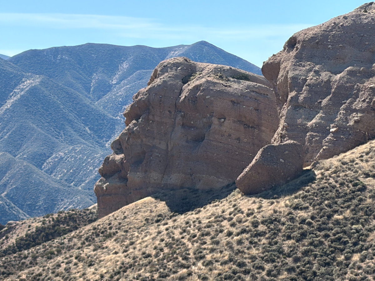
A segment of Three Sisters Rock near the Agua Dulce and Acton area of L.A. County.
(Jaclyn Cosgrove / Los Angeles Times)
1. Three Sisters Rock via the Pacific Crest Trail
Distance: 7.5 miles
Elevation gained: About 1,700 feet
Difficulty: Moderate
Dogs allowed: Yes
Nearest to: Agua Dulce and Acton
Accessible alternative: Acton Park Loop
This 7.5(ish)-mile moderate hike to Three Sisters Rock, a massive rock formation perched on the hillside, includes a stretch along the Pacific Crest Trail through a high desert-esque landscape with stunning monoliths of conglomerate and more. It’s hikes like these that remind us of how small we are as we pass by these giant rock formations.
This hike has minimal shade, and what appears to be the only water source, which you must filter to drink, is at the beginning. Pack plenty of water — more than you think you’ll need — and make sure to hike this trail on a cool day to prevent heat exhaustion. Additionally, I recommend wearing pants, as the trail has some overgrown segments and spots where you’ll encounter tumbleweeds. Lastly, my friend who hiked with me used a hiking umbrella and found that really helped with the intensity of the sun.
To begin your hike, you’ll park either at the Indian Canyon Trailhead parking lot or on the shoulder of Soledad Canyon Road next to the trail’s starting point.
From Soledad Canyon Road, you will head north over the Santa Clara River. This short stretch is a bit overgrown and can be buggy, but it’s also five minutes of your hike.

The beginning of the hike crosses through a riparian area along the Santa Clara River.
(Jaclyn Cosgrove / Los Angeles Times)
As my friend Astraia and I turned out of the wetlands, we passed through dense vegetation, including what looked like rubber rabbitbrush with bright yellow blooms. Astraia cried out. She’d been stung by a bee that’d gotten stuck in her hair as we crossed through the blooms. Likely because of the proximity to water, this was an especially busy spot for the bees, so take good care as you move through here.
A bit of ice and first aid for Astraia’s hand, and we were back on track. We were headed over the train tracks — be careful here! — and continued onward along the Pacific Crest Trail, a 2,650-mile journey that spans from Mexico to Canada. You’ll immediately start gaining elevation as you crunch over the sandy dirt. Don’t forget to breathe and take in the views. You can see Mt. Gleason and Messenger Peak poking out from the San Gabriel Mountains.

The view from the Pacific Crest Trail of the canyons and foothills in the Agua Dulce and Acton area with the San Gabriel Mountains in the distance.
(Jaclyn Cosgrove / Los Angeles Times)
About a mile in, you’ll spot a giant multilayered stone. Friends, this is a bonus rock! You have almost three miles to go before you reach Three Sisters.
Astraia and I stared in wonder at this ancient specimen, and I entertained her with a story about the one time I tried to simplify local geology in The Wild and thought I might lose my mind because of how complicated it all was. That’s to say, I think this is a type of conglomerate, but I am far from an expert. (Experts: Please email me and tell me what you think.)
Regardless, it’s amazing to look at the layers of these giant rocks and think of the stories they tell about the way these lands have weathered many storms.

The first massive rock formation you pass as you take the Pacific Crest Trail toward Three Sisters Rock.
(Jaclyn Cosgrove / Los Angeles Times)
For the next mile after this, be mindful of where you walk, as I found a few spots on the trail with patches of soft soil where I could have tripped as my feet sank down. Thankfully, I was going slow, in awe of the landscape around me (including a formation to the east that resembles knuckles in the hillside).
At 2 miles in, you will turn off the Pacific Crest Trail onto a wide dirt fire road. I thought it would be a fairly straightforward hike to Three Sisters Rock from here, but the road ahead has multiple intersections where you can easily make a wrong turn. That said, on your return, keep your eyes peeled for where you rejoin the Pacific Crest Trail, as your local outdoors journalist completely missed it!
The first intersection comes shortly after you start the fire road, where you’ll bear right (or northeast). You’ll know you made a wrong turn if you end up at the base of a transmission tower. Shortly thereafter, you’ll bear right-ish again to avoid another dead end to a transmission tower.

Another one of the layered rock outcroppings you’ll pass as you take the Pacific Crest Trail toward Three Sisters Rock.
(Jaclyn Cosgrove / Los Angeles Times)
About 2.8 miles in, you’ll see an option to turn left. Continue west on the fire road, following it south around a bend and then up, past another turnoff to a transmission tower about 3.1 miles in where you will bear left, continuing on the fire road. You are almost to Three Sisters Rock!
You’ll turn at about 3.4 miles onto a narrow well-trodden dirt trail down to the rocks. You’ll find three massive rock formations near other smaller heaps of geological history. There’s a nice flat area near the base of the rocks where you can have a snack or lunch break. You should use serious caution if planning to climb up the rock face, as it is not a simple scramble and poses some serious risks if you fall.
Astraia and I were pleased with how we spent the day. She repeatedly commented that, despite the occasional traffic noise from the roadway, it was near silent on the trail. We spotted multiple red-tailed hawks and whiptail lizards and were awed as we watched a raven (or maybe a crow) fly upside down, which we agreed was a skill we’d like to have.
We hiked the trail on a Sunday and saw only two other people with a friendly Brittany spaniel named Boss. They were surprised to see us until we explained we were headed to Three Sisters Rock. I hope you find a similar serenity out in this gorgeous high desert landscape!

The Devil’s Chair is one of the best lookout points in L.A. County. It is located in the Devil’s Punchbowl Natural Area near Pearblossom.
(Jaclyn Cosgrove / Los Angeles Times)
2. The Devil’s Chair Trail
Distance: 7.4 miles
Elevation gain: About 1,500 feet
Difficulty: Moderate
Dogs allowed? Yes
Accessible alternative: Prime Desert Woodland Preserve walking trail in Lancaster
The Devil’s Chair Trail is a 7.4-mile out-and-back hike that takes visitors through ancient sandstone formations of every imaginable shape and size. It’s a great all-day adventure for adults, teenagers and older kids. The trail leads to one of the most epic lookout spots in L.A. County: The Devil’s Chair! (Less spooky than it sounds, though.)
About an hour-and-a-half drive from L.A. near Pearblossom, the hike starts in the Devil’s Punchbowl Natural Area, a 1,310-acre L.A. County park with massive sandstone rock formations and a healthy desert landscape of juniper and Joshua trees, along with native wildlife, including bighorn sheep.
Upon arriving in the large parking lot, you’ll find vault toilets and a visitor check-in area. The nature center is a great stop with live snakes, bugs and other crawly creepers inside. The rosy boa and tarantula are among my favorites to view.
The Devil’s Chair Trail was previously closed because of storm damage, but reopened thanks to the diligent work of county staff.
Its trailhead is in the southeast corner of the parking lot. The first mile of this hike is arguably the hardest part because you gain 500 feet in just under a mile.

The Devil’s Punchbowl Natural Area sits near the San Gabriel Mountains.
(Jaclyn Cosgrove / Los Angeles Times)
After catching your breath, you’ll turn left (or east), cross a seasonal creek and hike for just over 2½ miles on a gentle path.
As you hike along the trail, you’ll likely spot chipmunks and gray squirrels. I frequently hear a variety of birds when I hike in the park, including hawks, ravens, white-crowned sparrows and dark-eyed juncos (which are very cute).
You also get incredible views of the desert below and mountains in the distance, including nearby Table Mountain in Angeles National Forest and the Tehachapi Mountains in Kern County.
To reach the trail’s namesake, you will walk down a narrow fenced path to a small boulder, surrounded by a short fence, that overlooks the valley below. This is the aforementioned devil’s chair. It’s a great spot to take a family selfie, share snacks and reminisce. And if you’re lucky, you might spot bighorn sheep in the valley below.

A hiker celebrates from a peak at Vasquez Rocks Natural Area in Agua Dulce. The rocks were used in many television shows and movies. Vasquez Rocks are named for the outlaw Tiburcio Vásquez, who used the rocky hills as his hideout.
(Myung J. Chun / Los Angeles Times)
3. PCT and Apwinga Loop Trail at Vasquez Rocks Natural Area
Distance: 3.4 miles
Elevation gain: 600 feet
Difficulty: Moderate
The first time I visited Vasquez Rocks Natural Area, I drove up, explored its famous rocks that jut from the ground like massive flying saucers, and then left. But this park has more to offer than spots to reenact Captain Kirk’s fight with the Gorn in the original “Star Trek.”
To begin the loop, you can start at the gate after parking near the nature center (which features fun movie memorabilia of films made at Vasquez).
Follow the Pacific Crest Trail clockwise and you’ll soon find yourself with your first great view of the park, including its iconic slabs of earth. You’ll follow the trail as it passes next to large rocks — including one that resembles a T. rex — before entering an open area with a green picnic table beneath a pepper tree. Continue following the PCT.

The formations at Vasquez Rocks are diverse in shape and color.
(Jaclyn Cosgrove / Los Angeles Times)
Soon, you’ll notice trail signs noting that you’re on both the PCT and the Apwinga Loop Trail. The PCT will eventually jag southeast. You will continue following the Apwinga Loop. Here you’ll see so much more than those big famous rocks: sweeping vistas, purple-red rocks to scramble along, native desert plants, like buckwheat and yucca, and — depending on when you visit — plenty of solitude.
I enjoyed looking at the numerous rock formations and, like a high desert Rorschach test, deciding what I thought they looked like: a bolt screwed into the ground, stacks of vinyl records and pancakes. (Maybe I was getting hungry at that point.)

A section of the Pacific Crest Trail runs through Vasquez Rocks Natural Area in Agua Dulce.
(Myung J. Chun / Los Angeles Times)
In terms of difficulty, this trail is firmly moderate. Parts of it are flat or gently sloping, but you will run into a few stretches where you will briefly huff your way up. You will walk near the 14 Freeway for a bit, but unlike the drivers, you’ll have a close-up view of these remarkable rocks, formed an estimated 25 million years ago, when their “sediment was spread across alluvial fans — cone-shaped deposits that develop as fast-moving streams empty onto relatively flat plains,” according to NASA.
Vasquez Rocks has different hours depending on the season. From Nov. 1 to Feb. 28, it’s open from 8 a.m. to 5 p.m. Tuesday through Sunday. Its spring and summer hours, which run from March 1 to Oct. 31, are 8 a.m. to 7:30 p.m. Tuesday through Sunday.

3 things to do

A big brown bat is one of many bat species that call L.A. County home.
(Carolyn Cole / Los Angeles Times)
1. Behold bats in San Dimas
The San Dimas Canyon Nature Center will host Bats of the Angeles National Forest from 6 to 7 p.m. Friday in San Dimas. Visitors will learn about multiple species of bats that flap about our mountains. Learn more at the nature center’s Instagram page.
2. Hike to the sound of ghost stories in L.A.
Naturalist and outdoors educator Jason Wise will host Curse of Griffith Park Hike at 6 p.m. Thursday along the park’s trails. Wise will lead hikers on a 2-mile jaunt as he points out spiders, bats and owls, and shares about local lore and legend. Kids and dogs welcome. Suggested donation of $25. Register at eventbrite.com.
3. Hunt for treasure in Long Beach
Real estate agent David Sanchez, a longtime organizer of paddling events in the South Bay, will host a Halloween scavenger hunt from 10 a.m. to noon Saturday in Long Beach. Participants will join the spooky hunt for hidden treasures on the water using their own (or rented) stand-up paddleboards, kayaks or other vessels. Register at eventbrite.com.

The must-read

Some of the infrastructure for the Mt. Waterman ski resort.
(Chris Erskine / Los Angeles Times)
The Mt. Waterman ski resort is for sale — again. In 2024, hikers collectively cringed when the news broke that an investment firm was angling to turn Mt. Waterman into an exclusive ski club with pricey memberships, which included chartered helicopters up the mountain. That plan shockingly didn’t work out. Times staff writer Lisa Boone wrote recently about how the ski resort has been relisted, this time for $3.275 million. “We have the steepest skiing in Southern California,” said listing agent Marc Ramirez of Pacific West Business Properties, referring to the black diamond slopes. “We offer advanced skiing you can’t find unless you drive to Mammoth.” He said he’s received about 25 calls a day since the listing went live and is in serious talks with two potential buyers.
May the next buyers understand the spirit of public lands.
Happy adventuring,

P.S.
Quickly, a bit of trunk-cated news: State and local officials secured $1 million to acquire private property in the Elephant Hill area of El Sereno. This will allow the public land known as Elephant Hill Open Space to grow more, providing even more green space for a community that’s fought long and hard for it. You can hike through Elephant Hill’s new trail using the route I developed that connects multiple green spaces in Northeast L.A. Enjoy!
For more insider tips on Southern California’s beaches, trails and parks, check out past editions of The Wild. And to view this newsletter in your browser, click here.