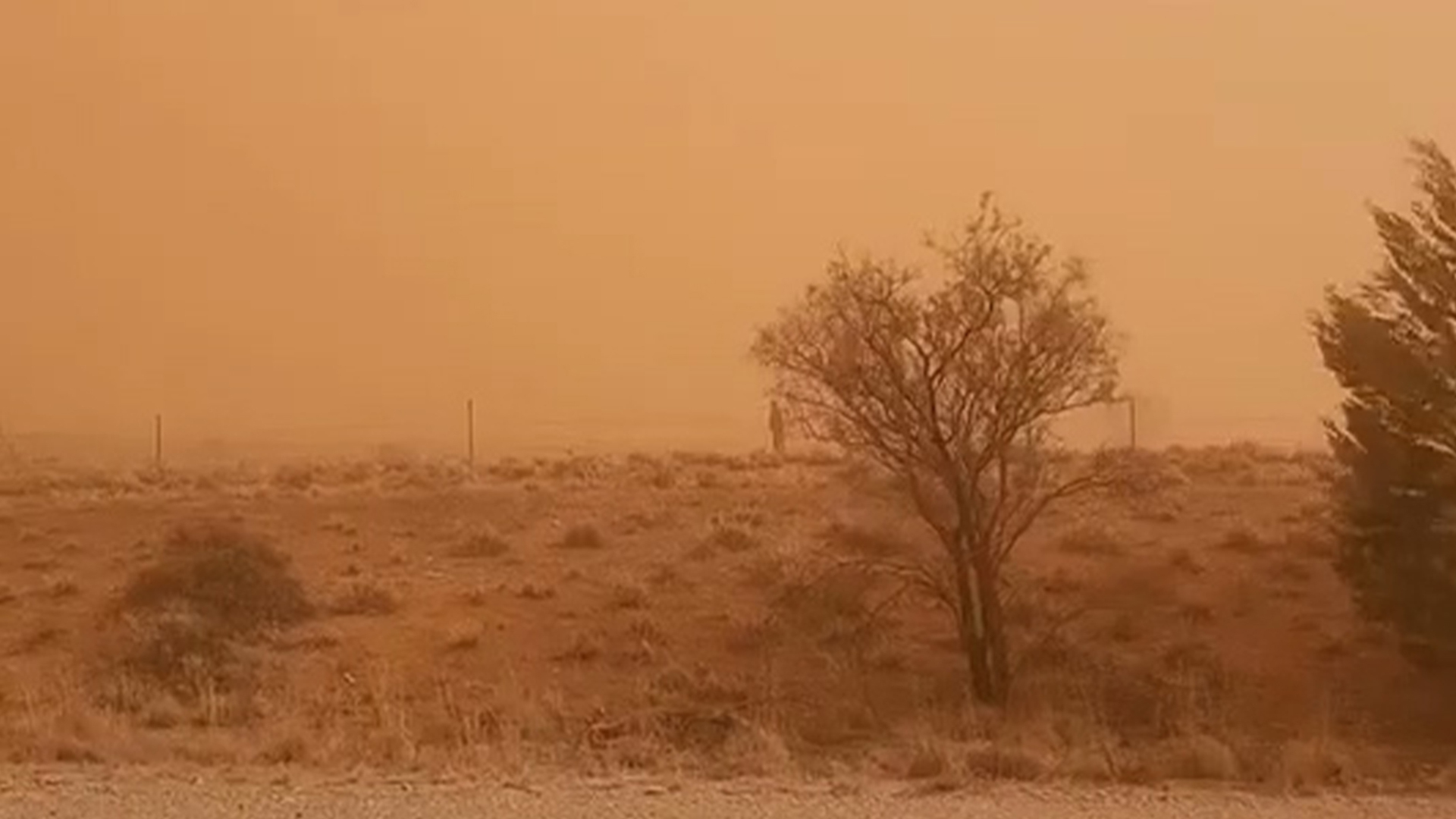
Australia dust storm turns town orange
Video shows a severe dust storm turning an Australian town orange as strong winds whip across South Australia
Source link
Video shows a severe dust storm turning an Australian town orange as strong winds whip across South Australia
Source link

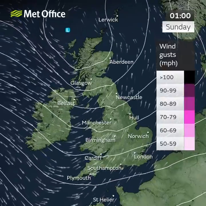
THE UK was battered by 50mph winds and heavy rain last night, as the country braces for wet weather.
Forecasters have warned that it will rain every day next week, in what will be a very wet start to June.

4

4
4
The news comes after Britain experienced one of its driest Mays on record, with some parts of the country prepping for droughts.
The North-West and North-East have also experienced their driest starts to the year since 1929, with Brits basking in sweltering 27C heats.
According to Met Office meteorologist Becky Mitchell, though, that seasonal abnormality has come to an end.
She said: “Last night’s rain won’t have brought May much closer to average.
“That being said, we still have a week left of May and we expect to see rain every day, so by the end of the month we could be closer to the monthly average.”
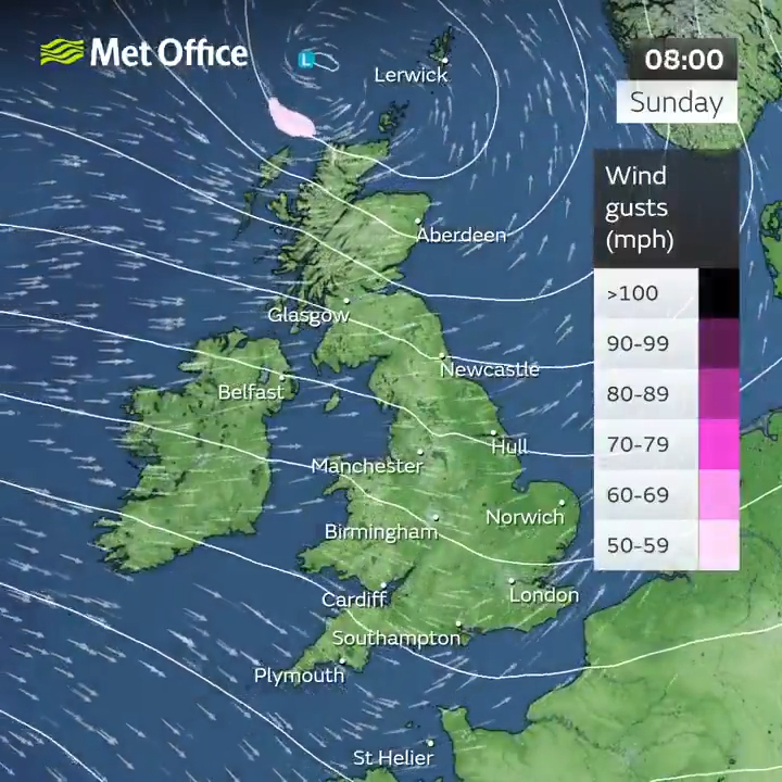
Fellow meteorologist Zoe Hatton added that showers will sweep across the country from Sunday onwards.
She said: “Across the north of the countryside of Scotland is likely to be wet and quite miserable initially.
“A band of rain will be moving eastwards overnight lingering in the far north of Scotland. Elsewhere it’s not going to be widely wet.
“There’s going to be low cloud in places which could produce outbreaks of rain across the Pennines and across higher ground in the south of England, but the main focus will really be northern Scotland.
“As the day moves on that band of rain will move eastwards and we’re going to see showers arriving from the west.
“The most likely places affected will be Northern Ireland, Scotland and the north of England, and some quite frequent blustery showers across parts of the country, but drier further south.”
Heavy winds peaked at 50mph in the north of England on Saturday, while temperatures across the country will peak at a meager 15C on Sunday.
Some southern areas, including London, could experience highs of 21C, though, on Wednesday and Thursday.
However, Becky has warned that the warmer weather might not return until the school half-term.
Temperatures will begin to rise after June 2, bringing an end to what is believed will be a very wet week.
Over the last few months, Britain has experienced a variety of rare weather conditions with meteorologists warning of a tornado on May 21.
One spokesperson said: “It’s not out of the question that we could see a funnel cloud, maybe even a brief tornado across parts of the South East.”
Tornadoes form when hot, humid air collides with cold, dry air.
The cold air heads downwards, while the hot air rises – creating a funnel, which eventually spirals into a tornado.
Due to the UK’s landscape and normally temperate weather, tornadoes are a rarity in Britain.
4
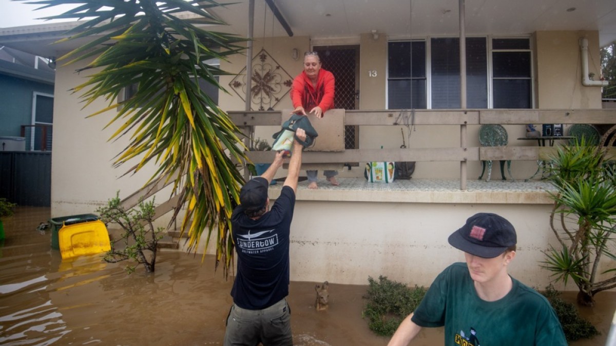
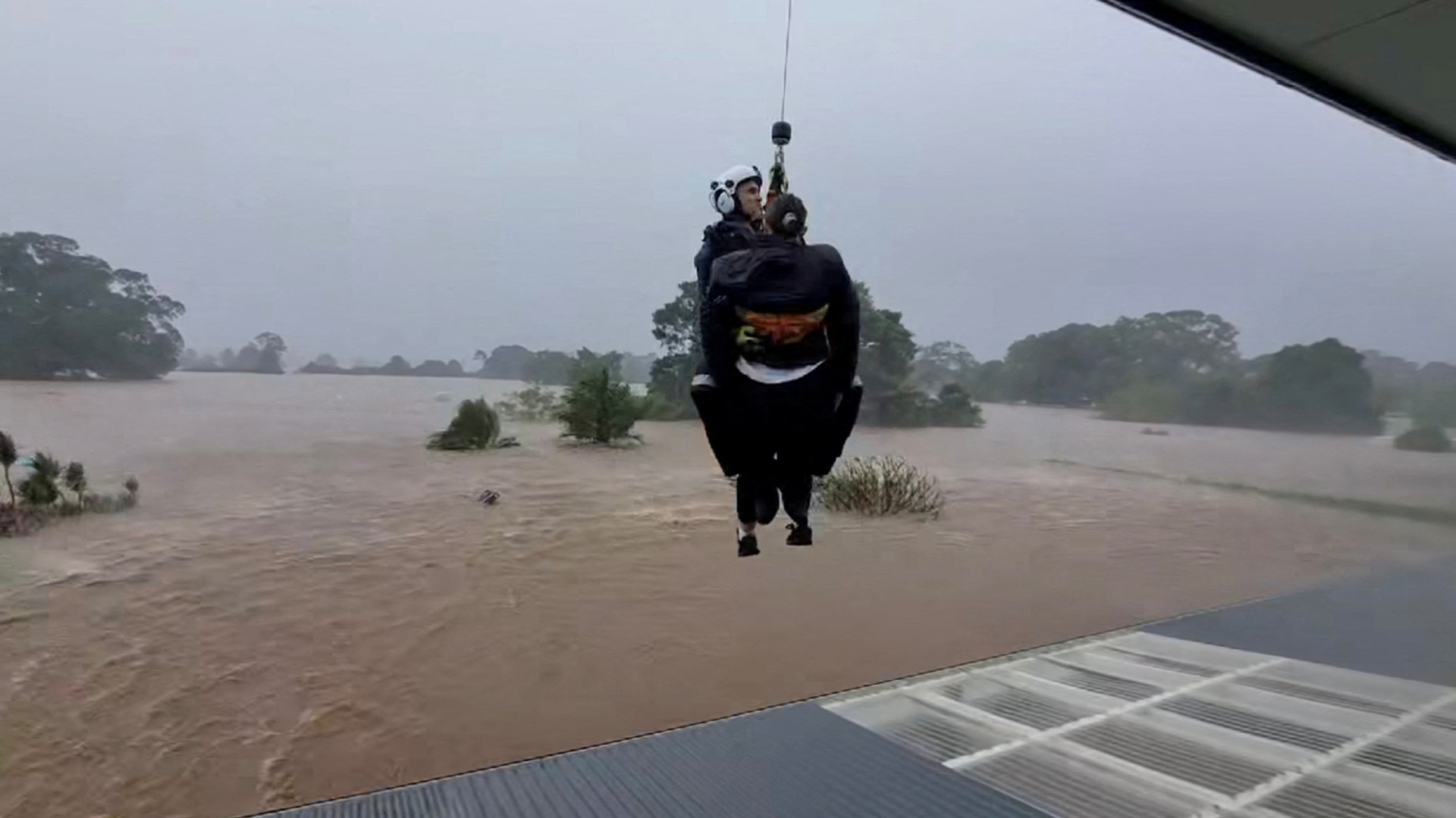
About 50,000 people are still isolated across New South Wales after a powerful weather system dumped months of rain in three days.
Record-breaking floods in eastern Australia have killed four people and stranded tens of thousands after days of relentless rain.
Prime Minister Anthony Albanese and New South Wales Premier Christopher Minns visited affected communities on Friday, some of which have experienced their worst flooding on record this week.
Minns praised emergency workers and volunteers, who have rescued 678 people in recent days – 177 of them in the past 24 hours.
“It’s an amazing, heroic logistical effort where, in very difficult circumstances, many volunteers put themselves in harm’s way to rescue a complete stranger,” Minns told reporters.
“Without the volunteers, we would have had hundreds of deaths and we’re in deep, deep gratitude.”
As well as the four victims killed, one person is reported missing.
About 50,000 people are still isolated across New South Wales, the country’s most populous state. Entire towns remain cut off and roads submerged after a powerful weather system dumped months of rain in three days.
Flash floods tore through rural communities, washing away livestock, damaging homes, and turning streets into rivers. Coastal areas are now littered with debris and dead animals.
Authorities have warned returning residents to remain vigilant.
“Floodwaters have contaminants, there can be vermin, snakes … so you need to assess those risks. Electricity can also pose a danger as well,” said Emergency Services Deputy Commissioner Damien Johnston.
Australia has faced a string of extreme weather events in recent years, a trend experts attribute to climate change.
“What once were rare downpours are now becoming the new normal – climate change is rewriting Australia’s weather patterns, one flood at a time,” said Davide Faranda, a climate researcher at ClimaMeter, in comments carried by the Reuters news agency.
The storm system has now moved south towards Sydney, causing further disruption.
Train services, including airport services, were affected by flooded tracks. Sydney airport shut two of its three runways for an hour on Friday morning, delaying flights.
Officials also warned that Warragamba Dam, which supplies 80 percent of Sydney’s water and is currently at 96 percent capacity, may soon overflow.
Heavy rains in New South Wales have caused record-breaking floods, killing two people and isolating tens of thousands of residents. Authorities warn of more rain and life-threatening flash floods as emergency teams continue rescue efforts.
Published On 22 May 202522 May 2025

The National Weather Service in Alabama warned Monday that weather radio broadcasts are offline for routine maintenance as severe storms are forecast to hit the state Tuesday. “Weather products will continue to be transmitted via the Internet, weather apps and wireless emergency alerts,” according to NWS Birmingham. File Photo by Dan Anderson/EPA-EFE
May 19 (UPI) — The National Weather Service in Alabama warned Monday that weather radio broadcasts are offline for routine maintenance as severe storms are forecast to hit the state Tuesday.
The weather service said while all watches and warnings will be released over the next few days, the National Oceanic Atmospheric Administration’s Weather Radio transmitters will be offline during that time. Severe storms are forecast Tuesday for much of Alabama.
“NWS local offices plan to inform listeners both on-air and on their websites when updates are scheduled,” according to the NOAA Weather Radio website. NOAA Weather Radio is a network of stations that broadcasts warnings and weather information from the National Weather Service. The Advanced Weather Interactive Processing System, or AWIPS, went offline Monday and will remain down through Wednesday.
“Our Weather Radio broadcasts have concluded and will remain unavailable until our system updates are complete,” NWS Birmingham wrote Monday in a post on X. “Weather products will continue to be transmitted via the Internet, weather apps and wireless emergency alerts.”
NWS Birmingham systems are undergoing required upgrades. Our Weather Radio broadcasts have concluded and will remain unavailable until our system updates are complete. Weather products will continue to be transmitted via the internet, weather apps and wireless emergency alerts. pic.twitter.com/KbLRFtaTy5— NWS Birmingham (@NWSBirmingham) May 19, 2025
“During the time of the update, forecast operations will be conducted in conjunction with our service back-up office in Peachtree City in Georgia to minimize any potential interruption to services,” the National Weather Service said Monday. “No impacts to our core services of forecast products and weather watches, warnings and advisories are expected during this period.”
The software updates will impact transmitters across northern and central Alabama. The NWS said its forecast office in Birmingham will remain open and staffed during the maintenance.
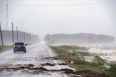
Approximately 31 million people from Texas, north to Iowa, could see severe storms starting Monday with forecasts showing strong winds, hail and tornadoes. That risk will shift Tuesday to Louisiana and north into Alabama and Indiana.
The NWS is urging Alabama residents to gather several weather sources — the Internet, weather apps and local emergency management — to ensure they receive all severe weather warnings in order to stay safe over the next few days.
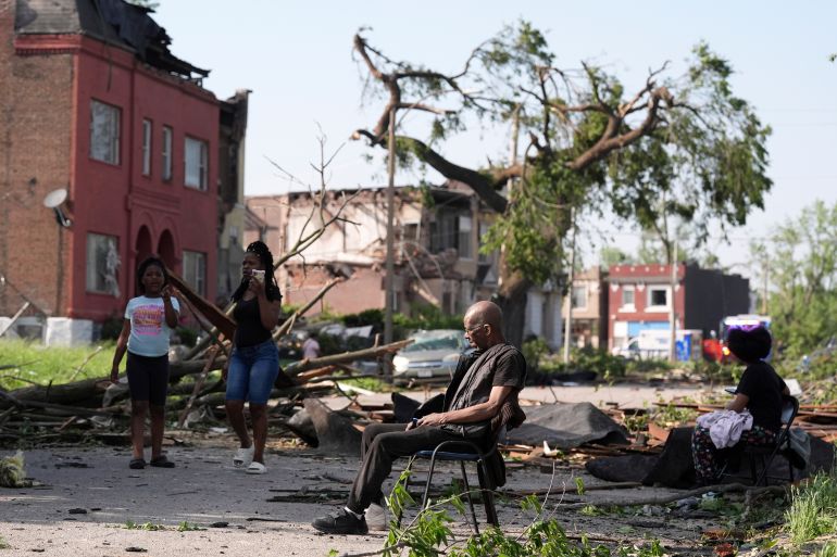
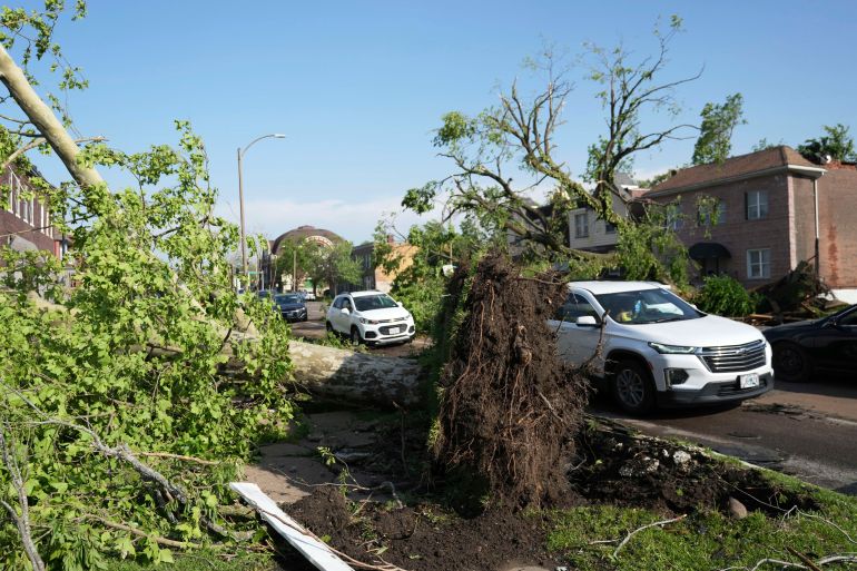
Deadly storms and tornadoes over the weekend hit 10 different states, including Texas, Kansas, Missouri and Kentucky, where at least 28 people were killed.
The storms are part of a severe weather system sweeping across the Midwest, leaving thousands without power.
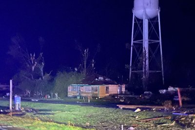
At least 21 people have died after tornadoes caused by severe storms swept through the states of Missouri and Kentucky in the United States, officials said.
Kentucky governor Andy Beshear on Saturday said on X that at least 14 people died in the Friday night’s storms.
At least seven others were killed in Missouri as authorities launched a search for people trapped in buildings.
Kentucky authorities said there were severe injuries when a tornado tore across Laurel County late on Friday. “The search is continuing in the damaged area for survivors,” the office of Sheriff John Root said in a statement posted on social media.
In Missouri, St Louis Mayor Cara Spencer confirmed five deaths in her city and said more than 5,000 homes were affected.
“Our city is in mourning tonight,” she told reporters. “The loss of life and destruction is truly, truly horrific.”
Another tornado struck Scott County, about 209km (130 miles) south of St Louis, killing two people, injuring several others and destroying multiple homes, Sheriff Derick Wheetley wrote on social media on Friday.
“Our first responders acted swiftly, even while the tornado was still active, putting themselves in harm’s way to provide immediate assistance and care to those injured,” he said.
The storms, which began on Friday, are part of a severe weather system that has also spawned tornadoes in Wisconsin, leaving thousands of people without power in the Great Lakes region and bringing a punishing heatwave to Texas.
A dust storm warning was issued around the Chicago area on Friday night. The weather service said a wall of dust extended along a 161km (100-mile) line from southwest of Chicago to northern Indiana that severely reduced visibility.
In Texas, a heat advisory was issued for San Antonio and Austin cities, with temperatures at a blistering 95F (35C) to 105F (40.5C). Parts of the southern East Coast, from Virginia to Florida, also battled with heat in the 90s (32-37C).
The National Weather Service Office for Austin and San Antonio said humidity over the weekend was expected to make temperatures feel hotter.
“There are concerns of heat exhaustion for people that aren’t taking proper precautions when they’re outdoors,” meteorologist Jason Runyen said, advising those affected to take breaks and stay hydrated.

1 of 2 | A photo from the Mississippi Highway Patrol shows destruction and emergency services at the scene after tornadoes tore through the the state in 2023. Nineteen people were confirmed dead. EPA-EFE/Mississippi Highway Patrol
May 15 (UPI) — A wide swath of the Midwest and Plains states is under a tornado watch and severe weather conditions are forecast to persist into next week, the National Weather service said Thursday.
The storms could prompt large hail, damaging winds and heavy rain. Tornadoes have already touched down in Wisconsin and Minnesota, where a twister damaged parts of a home and a grain bin in Swift County.
A dark and dominant cloud wall, which often presages a tornado, prompted officials to issue a tornado warning in downtown Minneapolis Thursday. The storms were moving West to East, and severe weather was threatening Chicago and Tennessee. Severe storms were expected in Nashville.
The Chicago metro area and northwest Indiana were under a tornado watch until 10 p.m. CDT., and the NWS issued a severe thunderstorm warning for a wider portion of the region.
Dangerous storms are likely to drop gold ball-sized hail and whip Cincinnati, Indianapolis, Louisville, Nashville and St. Louis with 75 mph winds which could down trees and power lines Thursday into Friday. The severe weather threat extends to the common border between Arkansas, Louisiana and Texas.
This is a developing story. Please check back for updates.

Interim report into sinking of superyacht that killed 7 off coast of Sicily said the vessel was ‘vulnerable’ to strong winds.
Investigators in the United Kingdom say a sudden blast of powerful wind was likely behind the capsizing of a superyacht owned by British tech billionaire Mike Lynch, which sank off Sicily last year, killing seven people.
Lynch, 59, and his 18-year-old daughter Hannah were among those who died when the 56-metre Bayesian overturned in the early hours of August 19. The voyage was meant to be a celebratory outing following Lynch’s acquittal in a major fraud case in the United States just two months earlier.
In a preliminary report released on Thursday, the UK’s Marine Accident Investigation Branch (MAIB) found that the vessel was “vulnerable” to strong winds – potentially even less severe than those recorded at the time of the incident. The report noted that this vulnerability was unknown to the yacht’s owner and crew, as it had not been documented in the stability guidance available on board.
The agency launched its probe because the Bayesian was registered in the UK. However, it acknowledged that access to key evidence remains limited due to an ongoing criminal inquiry by Italian authorities.
According to the UK report, the Bayesian had been moved the day before the accident to what was believed to be a safer location in anticipation of thunderstorms. But at about 4:06am local time, with the vessel in a motoring state, sails stowed and the centreboard raised, it was hit by winds exceeding 70 knots (81 mph), which caused it to capsize within seconds.
“You have the wind pushing the vessel over and then you have the stability of the vessel trying to push the vessel back upright again,” said MAIB investigator Simon Graves. “What our studies found was that the Bayesian may have been vulnerable to high winds, and these winds were likely present at the time of the accident.”
Among the other victims were Jonathan and Judy Bloomer – both British nationals – Chris and Neda Morvillo from the US, and Canadian Antiguan chef Recaldo Thomas. Fifteen people survived, including Lynch’s wife, Angela Bacares.
Efforts to recover the yacht have stalled since May 9, when a diver was killed during the operation. Salvage work resumed on Thursday. Graves said the final report will cover additional factors such as possible escape routes and what took place on board.
“There’s still more to uncover,” he said. “Once we gain access to the yacht itself, we’ll be able to paint a fuller picture of the timeline and decisions made.”