Estel Farrell-Roig travelled to Romania with Intrepid to take on a section of the Transilvanica Trail, a 1,400 kilometer long route that crosses Romania diagonally from Putna to Drobeta Turnu Severin
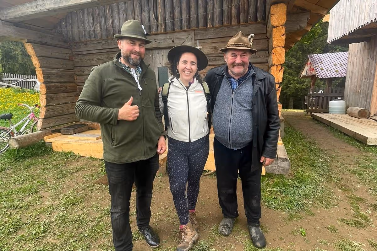
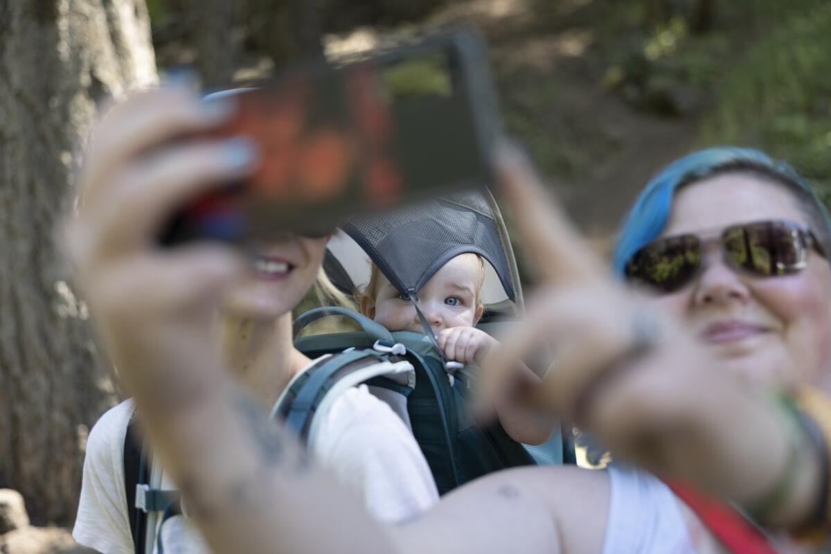
Me with a couple of hosts from one of the guesthouses where we stopped for lunch(Image: ReachPlc)
It’s not every year you turn 32. It’s also not every year you celebrate it by hiking around Romania.
Transilvanica Trail was sold to me as Romania’s answer to the Camino de Santiago, a walking route that stretches across northern Spain, which is enjoying a huge surge in popularity.
In its totality, the Via Transilvanica, or “the road that unites”, is a 1,400 kilometer long route that crosses Romania diagonally from Putna to Drobeta Turnu Severin.
As fun as that sounds, my journey was a little shorter. Guided by Intrepid, I was taking on five days of the route, managing around 10km a day. That might not sound like a lot, the idea of that much hiking made me nervous.
I needn’t have been.
What unfolded was a trip like no other, which left me desperate to go back for more.
Day 1
My alarm went off at 4.30am, ending a night at a Stansted Airport hotel. While this certainly felt brutal, the prospect of being on a flight without a three-year-old still seemed like a luxury to me. Compared to my usual journeys filled with Paw Patrol, drawing, toys and snacks, this was such an easy, smooth ride. I just slept.
Landed in Cluj-Napoca, trip leader Raluca bundled me into a minibus and we headed north.
Before setting off, we are fed (something the Romanians are very good at, as I will quickly learn). I loved the delicious pepper and mushroom soup with sour cream, while the roast chicken with potatoes was so full of flavour too. Little did I expect what a culinary journey I was about to embark on.
Day 2
Up at 8.30am after a good night’s sleep, I enjoyed a typical Romanian breakfast at the family-owned Pension Elegance at Guru Humorului.
The hotel itself is not pretentious – and not what we would probably class as a 4* hotel in the UK – but it is comfortable and homely. My room had a small balcony overlooking the gorgeous countryside. What else could I ask for?
First stop was the UNESCO-listed Sucevița Monastery. The painted monastery is home to 80 nuns and is gorgeous. Even having grown up in a country of Catholic churches, it was unlike anything I had seen before.
Afterwards, it was time to start hiking. The weather was a bit misty, but thankfully not rainy. Our hike started at Palma Pass checkpoint and led us through spruce forests. I found the hike on the first day rewarding and exciting; I felt pleased with myself for comfortably managing the 10km walk.
I was definitely ready for lunch by the time we stopped at Popas la Cosma, one of the guesthouses along the trail, famous for its authentic local dairy products made by shepherds. They could not have been more welcoming, showing us the accommodation and how they prepared the food. As well as the usual beds, there was an option to sleep in the hay barn.
We were served a delicious selection of meats and cheeses, as well as a yummy salad, but I am so glad I left room for dessert because the pancakes, filled with sweet cheese and blueberries, were incredibly moreish.
Day 3
A 45-minute drive away, we transferred to Sadova trailhead via Vatra Moldoviței. The second day of hiking – around 11km – was definitely the most challenging one of the three, most likely because the sunny, warm weather made the journey feel completely different from the previous day.
The process of walking through the woods, placing one foot in front of another, helped clear my head. By the end of our second day of trekking, I felt calmer and clearer-minded than I had in months.
The lunch stop at La Moara Bucovina restaurant was the best meal I had in Romania, without a doubt. Not only was the location breathtaking and the hosts incredibly warm and friendly, but the food was also excellent from start to finish. The highlight was a sarmale, a traditional Romanian dish consisting of stuffed cabbage rolls with rice and mince.
Our room for the night was at Hotel Dorna in Vatra Dornei, a ski resort town. Excited to be in a bit of a livelier place for the first time, I explored the beautiful, but quiet town before dinner.
Day 4
On our third day of hiking, we drove to the Mestecăni trailhead, where there is a small, ridiculously cheap souvenir shop. I bought two mugs, three painted eggs and a jigsaw puzzle for £10.
Despite it being our third day of walking, the day’s hike feels easier. Perhaps my legs had gotten stronger. The highlight was the wildlife we saw, including a frog and a couple of snakes.
The lunch spot was another idyllic guest house with staggering, far-reaching views. As well as serving scrumptious food, Gigi Ursu Chalet has a lovely terrace where you can sunbathe on a sunny day. Happily, the rays were shining for our visit, providing a perfect atmosphere for me to meet the two resident puppies and a gorgeous, friendly back cat.
Day 5
Our last day was another travelling day, driving about three and a half hours back to Cluj-Napoca. Having some tasty pasta for lunch in a sunny square, we had a bit of time to explore the city centre before having to head to the airport.
The Via Transilvanica may not yet compete with the Camino de Santiago or Via Francigena, the iconic pilgrimage that links Canterbury and Rome, it has something else. A rawness and a quietness that come from walking through parts of the world far from where most ever tread.
It was sadly time to head back to the UK, but this short trip will stay with me for a long time – and inspire me to go on more hiking holidays.
Book it
Intrepid Travel’s 10-day Hiking in Romania: Via Transilvanica Trail costs from £1,616pp which includes accommodation, ground transport, services of a local leader, guided hikes and some meals and other activities. Book at intrepidtravel.com or call 0808 274 5111.
‘Uh oh, look at these!” I call to my friends, Annie and Mike. “Ominous,” remarks Annie. Mike raises an eyebrow. We’re hiking the Pevensey Levels, marshland first drained in 772, home now to sheep and cattle, but also water spiders, living underwater in air-filled webs. The ground is pocked with endless impressions of horseshoes.
“It’s almost as if an army came this way,” I say.
And we laugh, but only because we missed that army by 959 years. Annie, Mike, Fflos the dog, and I are on our first day of following the 1066 Country Walk across East Sussex, beginning at Pevensey, ending in Rye. At the midpoint is the town of Battle, where we have rented an outbuilding conversion for three nights. Battle is known as the probable site of the Battle of Hastings: the brutal killing field where about 2,000 Normans, 4,000 Anglo-Saxons and 700 horses died one day in October 1066, according to various sources, leading to William the Conqueror defeating King Harold for the crown of England.
Battle Abbey. Photograph: Maciej Olszewski/Alamy
History commands an immediacy outdoors that it doesn’t in books. You ask different questions on foot. We were on the Levels at the same time of year, September, as the Normans: did they note the blackthorn heavy with sloes? Spot blackbirds feasting on blood-red hawthorn berries? Hear the wind in the rushes alongside the River Pevensey? Did they remark how faded yet abundant this land was on the cusp of autumn? Doubtful, but the contradictions of war-making in such a gentle place – gentle light, gentle breeze, birdsong and river currents – make an impression on us. We notice how the landscape offers the same russet, sage and ochre hues as the Bayeux tapestry.
The 1066 Walk covers 31 miles, and we’ve given it four days: Pevensey to Herstmonceux, 6 miles; Herstmonceux to Battle, 11; Battle to Icklesham, 9; and Icklesham to Rye, 5. Our second day is the longest and steepest, and yet my favourite, as it establishes a pattern that continues throughout. We pick up the well-signposted route in the green secrecy of Wartling Wood, carpeted in acorns, lined by blackberries, and follow it around sunny fields. We emerge into the neat village of Boreham Street, plunge down a holloway guarded by beeches, and roll out into more fields with windswept, distant horizons. The impression is of a settled, well-inhabited landscape – a feeling augmented by morning tea at the Ash Tree Inn in the hamlet of Brownbread Street – but another deeper, more enduring impression underlies it.
Perhaps because the route is designed to call the distant past to mind, with every shift of scene we experience a slippage of time. One moment we’re walking down a contemporary street being passed by speeding cars, then we slip through a small opening in a hedge and plunge not only into fields or woods, but out of the present into time immemorial. There’s a constant weaving in and out of darkness and light, wildness and cultivation, close-grown tunnels of greenery and wide-open, windy spaces, and with each shift comes a hurtling from present to past and back again. The effect is of a temporal quilt sewn with our own footsteps. We encounter few other walkers to break the spell.
Colour saturated … St Thomas church in Winchelsea. Photograph: Nelson Art/Alamy
Elasticity of time is most apparent on Tent Hill, where, as Mike puts it, “the reward to effort ratio is quite good”. Sources suggest one army or the other – no one knows which – camped here, hence the name. Instead of troops, we discover an ancient horse chestnut with branches so immense they have touched the ground and put down roots of their own, creating a family of trees around a living, central ancestor. Joining their company is occupying past and present at once.
Because Mike has had the good sense to rent accommodation at Abbey View Cottages – there is indeed a view of Battle Abbey’s towers – we set forth on day three from our own digs. Another plunge off a country lane lands us on a bridle path in Battle’s Great Wood, where Mike announces: “My fungi sense is twitching.” Soon he is giving a mushroom tutorial: fly agarics; edible boletes and parasols; great penny buns (“the Rolls-Royce of mushrooms,” Mike pronounces).
And then the temporal hopscotch continues. One minute we’re crossing a golf course, the next we’re in deep countryside with venerable oasthouses tucked into hill folds. Shortly before arriving at the welcoming Three Oaks pub, we come upon one of artist Keith Pettit’s 10 Bayeux tapestry-inspired sculptures on the route: six hollow, Celtic-carved oak pillars planted inside with hawthorn. Together they form a circle of growing, living wonder on a hillcrest.
Rye: ‘A town of Henry James, antique shops and good food’. Photograph: Jenifoto/Getty Images
Our final hike brings us to medieval Winchelsea, rebuilt by Edward I in the 1280s after the original town was washed away. We have traversed apple orchards and spent the morning in mellowness reminiscent of Dutch landscape paintings. To our joy, the modern stained glass windows of Winchlesea’s St Thomas church, created by Douglas Strachan as memorials following the first world war, bloom on the route like colour-saturated rainbows.
From Winchelsea, we head to Rye across the silted-in, coastal lowland that would have been underwater in Edward’s day. With Rye in eyeshot, we depart from the official 1066 Country Walk to detour past the ruin of Camber Castle, pressed into the flatland by a big, heavy sky. Begun in 1512, finished in 1544 and demolished in the 1640s by parliamentary forces in the English civil war, it’s a reminder of vulnerability – the waves and threats of invasions this coast has seen – and hubris, simultaneously.
With a final shift of perspective – pastureland to townscape – we fetch up in pretty, comfortable Rye, town of Henry James, antique shops and good food. We are more energised than exhausted, and grateful we didn’t have to conquer this place with anything more than our imaginations.
The Bayeux tapestry is on display at the British Museum from 10 September to 11 July 2027’ tickets now on sale. Abbey View Cottages sleeps four, from £200 a night; rooms as the Ship Innin Rye from £75.
Pamela Petro is the author of The Long Field,published by Little Toller (£14). To support the Guardian buy a copy at guardianbookshop.com. Delivery charges may apply.
Even before the first naira changes hands or the first customer calls, Musa Lekki reaches for his phone. It is 5:32 a.m. on a Tuesday, and like many smartphone users, he begins his day with a glance at his phone screen. The 42-year-old provisions trader lives in Yola, northeastern Nigeria, and runs a small wholesale business supplying neighbouring shops and customers with rice, beverages, and household goods.
As he unlocks his phone, there is already work waiting for him. A supplier has sent a voice note. A customer wants to confirm a payment. Another customer has placed an order. Before he has even left his bed, Musa is responding to messages and preparing for the business day ahead.
What appears to be a routine start to the morning is also a series of digital interactions. Within minutes of waking up, Musa has engaged with systems that recognise his phone number, device information, account credentials, and network location.
Each interaction leaves a data trail. A phone call generates telecommunications records. A bank transfer creates transaction logs. A utility payment produces another digital entry. Individually, these fragments may seem insignificant. Together, they form an increasingly detailed portrait of everyday life, which is increasingly mediated and supported by Digital Public Infrastructure (DPI) rails, a set of foundational digital systems that form the backbone of modern societies, enabling secure and seamless interactions between people, businesses, and governments.
Musa does not think about any of this. Most mobile phone and internet users do not.
“During the day, I use my phone for transfers, calls, and ordering goods, and by night I check my account balance before closing for the day,” he said.
As Nigeria expands its digital identity and payment systems, everyday activities such as making calls, sending money, paying bills, and accessing services are becoming increasingly dependent on interconnected digital infrastructure. Musa’s daily routine shows how Digital Public Infrastructure is reshaping daily life, expanding access to services while also raising questions about privacy, transparency and accountability.
What Musa sees is a phone. What he does not see is an invisible infrastructure that increasingly determines who can communicate, who can make payments, who can access services, and who can participate fully in modern economic life. By the time he goes to bed, several institutions will have processed fragments of his personal information. Many of those interactions will happen without him ever knowing.
This is how millions of Nigerian residents increasingly navigate life as data points within systems they rarely see.
The identity that travels ahead
At 6:45 a.m., Musa calls a supplier in Kano. The conversation lasts less than three minutes. It is a routine business call, yet that call depends on a national identity system. In 2020, the Nigerian Communications Commission (NCC) directed all mobile network operators to link users’ Subscriber Identification Module (SIM) cards to their National Identification Number (NINs) and to bar those who did not comply. Musa’s line was among those affected.
“There was a time my SIM was restricted because of an issue with my NIN linkage,” he recalled. “I couldn’t make calls for some days and also lost customers, until I sorted it out.”
The experience taught him something many Nigerians have learned: The ability to make a phone call increasingly depends on proving who you are. Identity is one of the key layers of a DPI. In Nigeria, the NIN is the foundational identity document, managed by the National Identity Management Commission (NIMC).
As of December 2025, the NIMC reported more than 127 million NIN enrolments nationwide, making it one of Africa’s largest digital identity databases, while over 172.67 million SIM cards had been linked to NINs.
Nunaya David, a senior enrolment officer at the NIMC, Yola, said, “NIN is increasingly required for banking, telecommunications, social programmes, and several government services.” Identity is no longer simply something Nigerians carry in a wallet; it is increasingly verified continuously in the background.
The money moves, the data moves too
Shortly after 7 a.m., Musa pays ₦45,000 to a supplier. The transfer takes less than a minute. Money leaves one account and appears in another. With a few taps, Musa has interacted with another stack of the DPI: the payment layer. Behind that transaction, the payment infrastructure operated by banks, fintechs, and the Nigeria Interbank Settlement System (NIBSS) performs multiple checks.
“Once a transfer is initiated, the request passes through several systems before reaching the recipient,” Hakeem Abdulkareem, a tech specialist with NIBSS, explained. “These systems communicate with one another to confirm and complete the transaction.”
Identity verification, fraud screening, account authentication and transaction routing all happen in the background. Most of it occurs within seconds. The customer sees only a debit alert while the infrastructure works in the background.
According to the Central Bank of Nigeria, electronic payment channels now account for the majority of retail payment activity, with internet transfers, mobile payments and point-of-sale transactions becoming increasingly dominant. Data from NIBSS show that Nigeria recorded ₦284.99 trillion in electronic payment transactions in the first quarter of 2025, representing a 17.7 per cent year-on-year increase compared with ₦234.49 trillion recorded in the same period in 2024. This reflects how deeply electronic payments have become embedded in everyday economic activity. Each transfer generates records that move across banks, payment switches, and settlement systems, creating the digital trail that allows modern commerce to function.
A market built on digital trust
For Musa, these systems are largely invisible. What he sees are payment alerts arriving on his phone and customers walking through his door. By mid-morning, those customers have started to arrive. One of them is Aisha Bello, a 21-year-old student at Modibbo Adama University, preparing for a new academic session. Like Musa, she relies on digital systems she rarely thinks about.
Her school registration requires identity verification. Her bank account relies on Bank Verification Number (BVN). Her mobile line and BVN are all linked to her NIN.
Get our in-depth, creative coverage of conflict and development delivered to you every weekend.
Subscribe now to our newsletter!
As she pays Musa electronically, two very different lives intersect through the same digital infrastructure. Neither sees the systems operating behind the scenes, yet both depend on them.
The same is true for Grace Ezra, a nurse at Modibbo Adama University Teaching Hospital in Yola. Like Musa and Aisha, she increasingly relies on digital systems to manage her salary payments, telecommunications services, tax records, and pension contributions.
Frank Akabueze, a digital identity expert, describes Nigeria’s journey as a gradual shift from fragmented systems to interconnected ones. “We have moved from having several disconnected identity systems toward greater integration.”
Increasingly, a person’s ability to study, work, save, communicate, and transact begins with a digital identity record. This speaks to the third layer of DPI, interoperability, the ability of different digital systems to speak to each other securely.
Musa operates his POS terminal. Photo: Obidah Habila Albert/HumAngle
The invisible checks
Around noon, Musa buys airtime through a mobile app. Moments later, he pays an electricity bill. The transactions feel routine, but each leaves a digital footprint. Each creates records, generates data and triggers some form of verification.
Airtime purchases, utility payments, transfers and merchant payments may appear unrelated, but increasingly they travel through interconnected platforms that rely on identity verification, payment infrastructure and data exchange mechanisms working together in the background. The power of DPI lies in the ability of these systems to communicate with one another. This interoperability allows a verified identity, a payment instruction and a service request to move across different platforms within seconds.
Esther Kolo, a staff member at Opay, a leading digital financial services provider in Nigeria, explains that many customers only notice verification during registration. “Most people notice identity verification during account registration, but checks can also happen when account details are updated or when unusual transactions are detected. In many cases, these checks happen in the background.”
The reality is that verification does not end after account creation. It becomes part of daily life. The systems simply become invisible. Every interaction leaves behind another record. Those records may sit in various databases, often connected in ways users never see. By midday, Musa has become far more than a trader buying and selling goods. He is part of a growing collection of records moving across this ecosystem.
When identity becomes the gatekeeper
Later in the afternoon, Musa receives a call from his younger brother. He is trying to resolve a problem involving identity records required to open a bank account.
Across Nigeria, mismatched records, incorrect dates of birth, missing details, and verification failures have become common sources of frustration. As systems become more interconnected, a discrepancy in one database can sometimes affect access to services that depend on another.
Such complaints have become familiar in identity management centres and online forums, where citizens report problems ranging from incorrect personal details and outdated biometric records to difficulties validating identity information across different systems. According to Nunaya of NIMC, “The person may experience delays in accessing certain services until the issue is resolved.”
As more services become interconnected, identity functions as a gatekeeper. When systems work properly, access becomes easier. When records fail, opportunities can disappear, sometimes without warning. The same infrastructure designed to enable inclusion can also create new barriers.
For instance, in August 2025, Catherine Bello, a beneficiary of a humanitarian cash assistance programme in Adamawa, was unable to receive support because a minor discrepancy between her name on the beneficiary list and her National Identification Number (NIN) record caused the verification process to fail. Similarly, others have recounted losing access to mobile services and facing banking restrictions because their NIN, BVN, and SIM records did not match across government databases.
Who is watching the data trail?
As evening approaches, conversations throughout the day prompt Musa to reflect on something he rarely considers: who actually has access to all this information? His answer is uncertain. “I know my bank, telecom company, and government agencies have my details. Honestly, I don’t really know who else can access the information or how it is being used.”
Digital rights advocates say Musa’s uncertainty underpins the challenges facing millions of Nigerians. As more services become digital and become interconnected through digital identity and payment systems, citizens often have little visibility into how their information is shared, stored, or processed across institutions.
Gbenga Sesan, Executive Director of Paradigm Initiative, a digital rights advocacy organisation, said the challenge is not only the collection of personal information but the lack of transparency surrounding its use.
“Many people provide information to access essential services without fully understanding where that data goes, who can access it, or how long it may be retained,” he said, adding that public trust in digital systems depends not only on efficiency and convenience but also on clear safeguards, transparency and accountability.
As identity systems, payment systems, and service delivery platforms become more interconnected, questions about transparency become increasingly important.
According to Vincent Olatunji, the Nigeria Data Protection Commission (NDPC), for identity management to be effective, there is a need for harmonised policies, secure technologies and inclusive systems. “The more systems are connected, the greater the impact if information is mishandled or exposed,” he noted.
Reports have shown how vulnerable these systems can be when safeguards fail. In 2025, the Foundation for Investigative Journalism uncovered websites that offered access to Nigerians’ sensitive personal information, including NINs, BVNs, photographs, and other identity records, for small fees. One platform reportedly sold access to personal records for ₦70-₦150, while another provided unauthorised identity-related services despite not being licensed by the NIMC.
Illustration: Akila Jibrin/HumAngle
These incidents illustrate the risks that emerge when large volumes of personal data are concentrated within interconnected digital systems without proper safeguards.
Olatunji of NDPC noted that the Nigeria Data Protection Act has established rules governing how personal information should be collected, processed, stored, and shared. Citizens have rights and organisations have obligations, but awareness is limited. “Organisations are generally expected to explain why information is being collected and how it will be used,” he explained.
Under the Act, citizens have several rights over their personal information. These include the right to know why their data is being collected, the right to request access to personal information held about them, the right to seek correction of inaccurate records, the right to withdraw consent for certain forms of data processing, and the right to seek redress when their information is misused. The law also requires organisations to explain how personal data will be used and gives individuals the right to lodge complaints with the NDPC when they believe their rights have been violated.
In practical terms, these rights mean that citizens are not merely sources of data, but they are entitled to ask questions about how their information is used, request access to records held about them, and challenge organisations that fail to protect their information. Yet awareness of these protections remains low among ordinary users.
Musa says he has heard of data protection laws but does not know what rights they give him. Like many Nigerians, he uses digital services every day without fully understanding who controls the information he generates.
Before bedtime, by 9:45 p.m., Musa checks his account balance for the final time. The day is over. He has made phone calls, received payments, sent transfers, paid utility bills, purchased airtime and verified identities. Each action took only seconds. Each left a record somewhere. Some records sit inside telecom databases. Others exist in banking systems, payment switches, identity registries and government platforms. Together they form a digital version of Musa’s day, one that is often more detailed than he realises.
“Many people do not realise how often their identity is being checked behind the scenes,” Frank noted.
This report is produced under the DPI Africa Journalism Fellowship Programme of the Media Foundation for West Africa and Co-Develop.
The fluorescent green gaiters seemed a ridiculous suggestion, but prove a godsend as we plod across the sand. “I bet you’re glad I told you to get a pair of these bad boys now, aren’t you?”my friend Luke jokes. We’re marching across a wide, crescent-shaped, honeyed beach. The sun is high in the sky and slivers of light flicker through a thick sea fog, as 6ft waves crash and fizz, their white foam licking the towering limestone cliffs.
I’m in Portugal, in the west Algarve, with two friends, hiking part of the Rota Vicentina, or Fishermen’s Trail, a 140-mile (226km) trek that runs from Lagos to São Torpes in Alentejo. Traversing cliffs that lead to wild, remote beaches like this one is part of the trail’s calling card. As the name suggests, it was originally carved out by fishers to reach otherwise inaccessible fishing spots along the Atlantic Ocean. Now it’s part of the Rota Vicentina, a hiking and cycling route spanning 466 miles across Portugal.
Already, this corner of the Algarve feels a far cry from downtown Lagos, where we’d been woken up the night before by noisy tourists after one too many Super Bocks. Our official starting point is 25 minutes away in Salema – a fishing village set within the Vicentine Coast natural park.
Barriga beach, on the Atlantic coast near Vila do Bispo. Photograph: Jose Luis Alvarez Esteban/Alamy
The sedate seaside haven is perhaps how the rest of the Algarve was before mass tourism arrived in this part of the Iberian peninsula following the opening of Faro airport in the 1960s. More than 20 million tourists visited the Algarve last year, 5.7 million of them from the UK.
Visitors to Salema drift in and out like the tide, pottering along cobbled streets, past traditional blue-and-white fishers’ cottages, stopping to indulge in fresh seafood on the terraces of family-run restaurants overlooking the long, empty beach flanked by chalky cliffs.
Tempted to postpone the first day of hiking to idle away the hours, we instead polish off a load of pastéis de nata and a bica or two down at Pastelaria Solmar, then set off. For the first few miles, we wend along a relatively flat, clay-coloured coastal path, following the blue-and-green striped Fishermen’s Trail logo that should lead us to Sagres.
A street in Salema. Photograph: CMS Pic/Getty Images
Keeping the sea to the left (we’re heading north), it’s easy to navigate. Magical, too, with views stretching as far as the eye can see, across an Atlantic Ocean glinting in the summer sun. Occasionally, we have to scramble up or down a steep, rocky embankment. But the rewards, a series of serene beaches that seem to get better with every mile, make it worthwhile. Given the remote location, these pretty coves attract only the hardiest beach-goers, and the odd naturist.
Over the day’s almost 12-mile hike, we hardly see another soul. So, when we arrive at Sagres, we’re ready for some human interaction. The seafaring town is where slave trader Henry the Navigator spent the final years of his life. Nowadays, Sagres is better known for its enviable surf breaks.
“I’m ready for a Sagres in Sagres,” Luke says, as we drop our bags and freshen up at Alojamento Mareta, a modest two-bed apartment that hovers on a cliffside with a blushing garden and sea views (about £78 per night). We mooch around looking for somewhere for dinner and a cold beer.
Sagres doesn’t have any sense of coherent organisation; its scattering of cafes, restaurants and bars appear to have been sketched out by bored teenagers when the city planners were on holiday. Instead of joining a growing gaggle of surfers waiting for live music to start at Three Little Birds, we order piri-piri chicken and a glug of local wine from the family-run Cafe Conchinha and retire to bed.
Waking early, we zip down to the empty Mareta beach for a meditation session led by another friend, James, before plunging into the icy sea. As if the morning isn’t already wholesome enough, we head to the Laundry Lounge – a boho, wooden-clad laundrette-cum-brunch spot – for a 90-minute yoga session and some breakfast before getting back on the road.
‘Craggy cliffs bathed in a golden light’ …. the lighthouse at Cabo de São Vicente. Photograph: Allard1/Alamy
We make our way to Cabo de São Vicente, where a 19th-century lighthouse sits perilously on an isolated rocky headland whipped by the elements. Mainland Europe’s most southwesterly point was known as the “end of the world”. It’s not hard to understand why. There’s nothing but an endless melange of blue water and craggy cliffs bathed in a golden light. It’s little wonder that the Greeks and Romans believed it to be a sacred promontory.
Later, we cut inland across a pancake flat expanse of arid shrubland with only the odd purple thistle for colour. Then, after 12 miles or so, we arrive in Vila do Bispo, a dusty, eerily quiet town, like something from a spaghetti western. Low-rise, pastel-coloured houses seem worn by time and old dusty cars sit beneath purple wisteria on cobbled street corners.
Fish, hung out to dry on washing lines, flap around in the wind as we wander the streets looking for somewhere to eat. We stumble across Pisco, an unassuming restaurant with a cosy atmosphere – whitewashed walls hung with art and crammed with wine bottles – where the vegetarian menu has excellent Mediterranean dishes, sourdough pizzas and organic wines.
Charging back towards the coast the following morning, we arrive at perhaps the most picturesque part of the hike. On the cliffs above Praia da Pena Furada, a vast, windswept beach, we perch on the cliffside for a moment to admire tall sea stacks battered by waves, the wind whistling through them as gulls swoop like kites overhead. It feels more like Steinbeck’s California than the Algarve. But for the hissing of the sea, everything is silent.
We barely say a word to one another until we land at the impossibly long sandy beach of Bordeira near Carrapateira a few hours later. The atmosphere here couldn’t be more different. The beach is busy with Portuguese holidaymakers and surfers. It’s the perfect antidote to hiking fatigue, so we settle in for a well-deserved burger at the hillside beach bar Amadobar as low-fi rock drifts from the speakers and surfers paddle out to distant breakers.
The hike ended at Praia da Arrifana in the Aljezur area of the west coast. Photograph: GM/Getty Images
Our digs for the night, which we make our way to after sunset, are about 20 minutes from the beach. Carrapateira Lodge (about £52 per night) sits in the centre of a small, charming whitewashed town with a scattering of restaurants, bars, cafes and surf shops. We dine alfresco on the cobbles just off the main plaza at O Pontal, getting to work on plates of tender octopus, roasted salt cod and beef entrecote to sustain ourselves for tomorrow’s final push.
When we arrive at Arrifana, our final destination the following afternoon, we’re beat. The parish town is settled on the hillside in the Aljezur municipality. Like Carrapateira, it’s popular with surfers. It feels closer to the Algarve most visitors know in some ways, but it’s still relatively low key. A single lane road helter-skelters down to another postcard-worthy beach, where there’s a sprinkling of bars and restaurants. Shattered, we round off the trip watching sunset at Café Restaurante Sol E Mar, a no-frills bar that spills out on to the headland overlooking the beach, which is busier than others we’ve passed but not as crowded as other Algarve hotspots I’ve visited. No rowdy Britons in sight – except us three.
My wife and I moved from London to Marseille a little over five years ago when our British passports still conferred “right to reside” in France. That first winter on the beach, in short sleeves, as our daughters played in the topaz-coloured Mediterranean and the sun set across an ever-clear blue sky, I understood why this part of southern France has always been popular with artists.
I was recently speaking about this with the painter Fanny Nushka and her sailor husband, Benoît Bouchet, on the terrace of Café la Muse in Marseille’s “coolest” neighbourhood. She said: “It took a long time to go back to blue. It’s like being in Paris and painting the Eiffel Tower. It’s dangerous to paint the Calanques [limestone coves] as an artist from here.”
We moved to Marseille for the same reason that has attracted countless artists: it’s cheaper to live here. Marseille’s affordability enables Fanny to paint full-time and Benoît to sail without being away from his family for weeks. Benoît runs daily catered cruises on a listed sailing yacht, Le Don du Vent. For €135, you get a taste of Mediterranean luxury with swimming, snorkelling and sunbathing in the unspoiled sea coves around Marseille, pausing briefly for wine and a lunch prepared onboard.
Always buzzing … La Friche in Marseille. Photograph: Hemis/Alamy
Céline Ghisleri, co-president of Provence Contemporary Art, which represents 62 arts organisations in and around Marseille, tells me the city has always had a dynamic art scene. However, the turning point came when Marseille was named European Capital of Culture in 2013. Since then, large institutions such as Frac Sud, Mac and the Museum of European and Mediterranean Civilisations (Mucem) have expanded the city’s offering with bigger exhibitions from more widely recognised artists.
This summer, the Mucem’s exhibitions are Bonnes Mères, a collection of contemporary and historical works on the theme of motherhood, and Clément Cogitore’s fascinating Ferdinandea, l’île éphémère, a body of work centred on the brief existence of a volcanic Mediterranean island. At the end of August, the art fair Art-O-Rama will be hosted at La Friche La Belle de Mai. La Friche (the Wasteland) was a tobacco factory and is now an enormous warren of a multidisciplinary arts centre that is always buzzing, especially in the summer when they set up a movie screen and food trucks on the roof. La Friche is emblematic of the art scene in Marseille: absolute chaos, but somehow it works.
Outside Marseille, Plein Sud, a network of contemporary art organisations between Monaco and Montpellier, produces a guide with travel itineraries. It’s how I discovered the charming Gallifet art centre in nearby Aix-en-Provence, which is only about 40 minutes from Marseille but exists in a completely different universe.
Mucem in Marseille. Photograph: Pcalapre/Alamy
You couldn’t be further away from Marseille’s port city energy than Aix’s daily market at Place Richelme, where you can grab a coffee and, if you are lucky, an outdoor seat at the patisserie and salon de théMaison Weibel. For lunch, I recommend Drôle d’Endroit (Funny Place). It is tucked down an alley off a sidestreet, but the meals are always pleasing and the atmosphere friendly. Another solid choice is Tita for Levantine street food.
As tiny and quiet as Aix is, it has an abundance of museums, such as the Granet Museum, the Caumont Art Centre and the Vasarely Foundation, but they tend to lean heavily on art that historians have already anointed. For example, it wasn’t until 1984 that the Granet acquired any works by the local boy done good, Cézanne, whose preserved studio is just up the hill.
A striking sculpture by Diadji Diop in the courtyard of Gallifet gallery, Aix-en-Provence. Photograph: Javier Larrea/Alamy
That’s why it was refreshing to find Gallifet trying something different. The owners, Nicolas Mazet and Kate Davis, have a mission to bring contemporary art to conservative Aix. Located on the ground floor of an 18th-century townhouse, the courtyard’s striking red sculpture of a swimmer mid-stroke, by Diadji Diop, hints that Gallifet is more than just a home (the owners live above the art centre).
This summer’s exhibition features a retrospective of the photographer François Halard, with more than 100 works spanning more than three decades. Until the end of September, Gallifet also hosts a seasonal restaurant and chef’s residency. This year, two Paris-based chefs, Lisa Desforges and Bruno Hammerle, will use Provence’s abundant and delicious ingredients to create menus including entrees such as smoked ricotta gnocchi with peas and a peapod veloute. Gallifet also offers two apartments (from €200 and €160 per night), both decorated with pieces from previous exhibitions and filled with Provençal features such as marble fireplaces and tomette terracotta tiles.
Palais des Papes, in Avignon. Photograph: Image Broker/Alamy
A little further up the Rhône, Avignon nestles against the river, enclosed by preserved medieval walls. The Palais des Papes overlooks the renowned vineyards of Châteauneuf-du-Pape to the north and lavender fields to the south. Each July, the town is taken over by the Avignon festival, one of the oldest performance arts festivals.
After a visit, take a walk along the most picturesque and charming street in Avignon, La Rue Peyrolerie. A winding medieval cobbled alley leads to an equally charming restaurant, L’Épicerie, situated in a square beside a small 14th-century gothic church with an ornately carved walnut-wood door. The cuisine is classic French, served in generous portions by friendly staff. Every time we visit Avignon, we dine here and have never been disappointed, but be warned that the terrace fills up quickly. This is a well-known and well-loved spot among locals. Another safe bet for outdoor courtyard dining is Numéro 75.
The most notable address for contemporary art in Avignon is the Lambert Collection, housed in two stunning 18th-century townhouses, Hôtel de Caumont and Hôtel de Montfaucon. The collection is the legacy of Yvon Lambert, a celebrated gallerist and collector who made his reputation in the latter half of the 20th century championing American artists such as Nan Goldin, Donald Judd, Lawrence Weiner and Cy Twombly. The collection continues to support up-and-coming local artists in its Antechamber of Summer exhibition. This year’s exhibition is by Melika Sadeghzadeh, an Iranian artist living and working in Montpellier.
Luma art complex, with a tower by the architect Frank Gehry, in Arles. Photograph: Hesham Elsherif/Getty Images
Just south of Avignon, Arles has at its centre a nearly 2,000-year-old Roman amphitheatre, which hosts plays and concerts. The Vincent van Gogh Foundation and Luma host several exhibitions throughout the year, but the real treat comes in July during the Rencontres d’Arles. For 50 years, venues across town, from galleries to grocery stores, have showcased a wide range of contemporary and historical photography.
Recently,we went to Arles for its Festival of Drawing. After a wander through the picturesque medieval streets of the Roquette district on the east side of town, popping into venues as we went, we discovered the tiny restaurant Páouin the quaint Place Paul Doumer. The menu promised sharing plates starring local produce and wines. So we sat down for another meal at another terrace table, under another clear blue sky.
It wasn’t my intention, but I played a role in shutting down John McCain’s Straight Talk Express.
It happened on a warm July afternoon as McCain traveled from a West Virginia airport to a rally in Ohio.
I had headed to the back of his bus with a small group of reporters, where as always McCain warmly motioned for us to squeeze in beside him on the couch.
The questions meandered across more than a dozen topics, but I asked if he agreed with his advisor Carly Fiorina’s recent statement that it was unfair for some health insurance companies to cover Viagra but not birth control — because McCain generally opposed those kinds of mandates.
Liberals and late-night comedians would later revel in McCain’s on-camera discomfort — the widening of his eyes, the awkward silence while he clutched his jaw and formulated an answer. But I had come to respect McCain’s frankness and his willingness to admit he didn’t always have an answer. Watching the question morph into an embarrassing “gotcha moment” for cable television, my stomach churned and my cheeks grew hot.
By July, I had covered McCain for almost seven months. I could recite many lines of his stump speech by heart, dreamed about his events at night and spent so much time scrolling through campaign e-mails on my BlackBerry that my fiance joked to our friends about the other man in my life.
Over those months, McCain had artfully created a sense of intimacy with the reporters who traveled with him. He barbecued for us at his Arizona cabin, and opened up about matters as personal as his faith and his son’s girlfriends. On one of my first days covering McCain, another reporter protectively warned me that it was important to be judicious with the material I used from McCain’s bus rides to keep the conversations in context.
Although the relationship was mutually beneficial, McCain offered accessibility and openness that was rare, if not unprecedented, in modern presidential politics. Now, as the presidential campaign plunges into its final days, that intimacy — real or imagined — has evaporated.
—
I joined McCain during the icy December days in New Hampshire when his confidence about a comeback seemed almost delusional. Inside the steamy windows of his campaign bus, the Straight Talk Express, McCain held court on a gray horseshoe-shaped couch at the rear, where we listened with rapt attention.
Back then, his staff often didn’t bother to listen to his rap sessions, which became an education for reporters on his world view. Early on, we learned to detect his disdain for some of his opponents — Mitt Romney and Barack Obama — by the way he lavished praise on others — Rudy Giuliani, Mike Huckabee or Hillary Rodham Clinton — in the same sentence.
He leavened policy discussions with funny stories from his school days when some knew him as “McNasty” or reliving his daredevil exploits as a young naval aviator. He was unguarded and charming, occasionally solicitous about our lives.
One winter afternoon when Cindy McCain joined him and he was stuck with three newly engaged reporters, he gave us a 10-minute treatise on honeymoon spots.
At the top of his list was Costa Rica, where he had done a zip-line canopy tour. Second was Montenegro and Dubrovnik, which he called “one of the really stunningly beautiful places in the world.” Third was Fiji: “The people are extremely friendly; they used to be cannibals, but the British cured them of that bad habit,” he joked. “We’ve gone to Fiji with our kids lots of times.”
In an aside about the Galapagos Islands, he veered into his last encounter there with sea lions: “I’m not making this up — I was swimming, and there was this group of female sea lions, and this one male sea lion, and the next thing I know this guy’s face is right where my hand is. . . . So I swam away and he bit my flipper. I swear to God. . . . He thought I was some kind of competition.”
“Where did you guys go on your honeymoon,” I asked.
“Uhh,” McCain said. “Hawaii,” Cindy interjected.
“Canada?” McCain joked, pretending to fumble. “I get my marriages mixed up.”
Cindy good-naturedly rolled her eyes. “We had a great time,” he said, grinning, before telling us about their honeymoon spot.
For several months, he would often lean in and ask the same question: “Did you set a date yet?”
—
McCain’s energy and sense of fun were most on display when he was surrounded by the regular characters in his entourage.
Before the primaries, there was Tim Pawlenty, the Republican governor of Minnesota, who was so unassuming that McCain’s bus driver once asked me what he did. Sen. Lindsey Graham (R-S.C.) loosened McCain up before debates or big events by subjecting himself to McCain’s unmerciful teasing. McCain loved to tell the story of Graham’s Ambien overdose on an international flight and how he had to be elbowed awake during a subsequent meeting with a head of state.
For the first half of the year, strategist Steve Schmidt and McCain speechwriter Mark Salter were regular fixtures in the press cabin. They offered honest observations about the direction of the campaign off the record, and lots of spin on the record.
We would persuade them to tell their own stories at the bar in the evenings. Salter had colorful tales of his days as a railroad worker in Davenport, Iowa, when he had hair past his shoulders and worked for a foreman known as “one-armed Ronnie.”
Schmidt could do dead-on impressions of his former boss, Vice President Dick Cheney, and had fascinating stories about managing the confirmation process of Justice Samuel A. Alito Jr. — always off the record.
They would complain about campaign coverage one moment and have drinks with reporters hours later. During a stop in Selma, Ala., I fell while out running and ended up with bleeding palms and scraped knees but no Band-Aids. Schmidt and Salter showed up at the hotel’s dining room with gauze and antiseptic.
—
At the time of that July bus ride with McCain, there was broad disagreement among his staff about whether the endless hours of questions were helping his quest for the White House.
In the driveway of the airport motel on the evening of the Viagra question, McCain’s aides made an argument that would shape their attitude over the next four months: If reporters were going to ask about issues that they deemed irrelevant to voters, why should the campaign give them access to the candidate at all?
Salter told me I had made the case for those who thought McCain should curtail his exposure to the press.
McCain aide Brooke Buchanan sarcastically asked whether contraception was next on my agenda. And Steve Duprey, the candidate’s usually jovial traveling companion who often visited the press cabin bearing Twizzlers and chocolate, twisted my question into what I interpreted as an accusation of bias: “Are you going to ask Obama if he uses Viagra?”
Later that summer, the frequency of McCain’s news conferences dwindled to late-afternoon, end-of-the-week affairs where he began calling more often on reporters he didn’t know.
We now watched from afar at most events — listening for the few sentences that would change each day in his stump speech. We would catch glimpses of him through the window of his SUV from five cars back in the motorcade or watch him get off the plane.
At the height of vice presidential speculation, we rushed the staff cabin of the plane, frustrated that no one was around to address the rumors.
“What do you want, you little jerks?” McCain said, using his former term of affection, before turning away.
—
On a recent Sunday during a brief stop at a Virginia phone bank, I got unusually close to McCain in the line of people waiting to shake his hand.
Tape recorder out and within a foot of him, I asked if he could talk about his new economic plan, which he was to unveil that week. The man who once asked me about my wedding date returned my gaze with a stare, shook the hand of the strangers to the right and left of me and continued out the door.
I remembered Graham’s explanation in January about why McCain spent so much time with reporters. He said that McCain felt too many politicians had become like a guy in a toothpaste commercial — you knew what he was selling but not what was behind the smile.
What McCain didn’t like about other campaigns and wanted to change, Graham continued, was that “nobody gets behind the curtain.”
Whether it was McCain’s fault or ours, the curtain had been drawn tight.
Imagine the Swedish landscape and a stereotypical scene of idyllic red cottages with white trim, foregrounded by a lake of glimmering blue, might spring to mind. Beyond perhaps, adding depth, lies a band of birch and spruce, and a midsummer view of wooded islands.
Now, add to this image the sight of two half-naked men lunging from a tiny sauna cabin into the cold shock of a lake. One screams. The other ducks his head under, pops up, shivers, then does it again. His skin has the pinkish tinge of salmon, but he’s smiling.
Those swimmers are my friend John and me (I’m the one grinning), and we’re quickly learning that the subversive joy of cold-water swimming – and stripping off in nature – are Swedish obsessions.
We’re on the first day on the Lelångenleden, a 112-mile (180km) cycle route of newly linked trails, which takes riders from the Bohuslän coast, north of Gothenburg, through the lakes of Dalsland and deep into the coniferous forests of Värmland, where the country is wilder still. The promise is traffic-free gravel roads and a segment that runs along the embankment of the discontinued Lelången railway, as well as a journey punctuated by stops in lake towns so charming they could easily be creations of Pippi Longstocking author Astrid Lindgren.
The scenery is dominated by forest and water. Photograph: Mike Maceacheran
But we’re up for a sterner challenge than the recommended four-day itinerary. Our plan, researched and booked online using West Sweden Trails’ helpful planning tool, is to split the route into three sections of about 40 miles each and cycle for up to five hours a day. Along the way, we’ll be staying in quiet hotels and a campsite where the food is as important as the lake setting.
“You won’t be alone,” says Erik Josefsson, founder of the Dalsland Experience, the tour organiser and bike shop that rents us our gravel bikes and bikepacking gear – for the next three days, we’ll be living out of frame and saddle bags. “Why not?” I ask Josefsson, a little disgruntled. “Sorry, I meant to say there’s plenty of wildlife in the forests!” comes the reply.
West Sweden’s burgeoning cycling scene is largely thanks to the ambition of the regional tourist boards. Now in development, the Västkustleden will be a new national cycle path between Gothenburg and the Norwegian-Swedish border, while the 105-mile Ljungleden opens this month and links together two of Sweden’s most popular trails (the Kattegattleden in Gothenburg and the Ätradalsleden in Falköping). More and more Swedes want to spend their summers cycling, and the Lelångenleden – affordable, family-friendly and largely flat – is tipped to become the next top-tier trail.
We start in the coastal village of Uddevalla, overlooking the beaten metal blue of the Byfjorden, setting off from the Strandpromenaden, a beautiful seaside boardwalk below granite cliffs – a few years ago, it was named Sweden’s most beautiful road. Then, before we head north, a 15-minute detour takes us to Gustafsberg, Sweden’s oldest seaside resort, with a beach, a jetty, a colony of crimson-tinted bathhouses and a historic lido converted into a hostel.
After four hours in the saddle, the fully serviced eco-campsite at Ragnerud Lake, at the foot of the Kroppefjäll plateau in Färgelanda, is a welcome stop for our first night. We check in to a cosy red cabin, then take canoes out on the lake and enjoy a restorative sauna, before watching the sun’s glorious rays cresting the treetops as the light fades. There is a very special quiet and otherworldliness to Sweden in the late summer.
The cycle route runs for 112 miles and includes several towns and villages. Photograph: Amplifyphoto/Markus Holm
Overseeing this wilderness are campsite owners Linus Bergström and Marielle Örtengren, who grew up on the lake, and the location offers access to one of southern Sweden’s largest hiking destinations. On their doorstep is 200m years of geology and 80 miles of trails.
The campsite’s sustainable restaurant Ragnerud Kök showcases the gifts of the forest – mushrooms, lingonberries, dill flowers. We share plates of kroppkaka (boiled potato dumplings) with chanterelles and brown hazelnut butter, and beef with beetroot and mushroom cream. Then it’s lingonberry-poached pears with forest marmalade. “We hike, we pick mushrooms. Then there is the pure thrill of jumping into the cold lake,” says Linus. “We love the simplicity of the forest and the slow pace of life.”
On untamed gravel roads the next day, red waymarkers guide us to the Dalsland Canal, a system of natural lakes and locks connecting 157 miles of waterways, where cold water swimmers regularly strip off, leaving John looking sheepish. Our cycle route soon morphs into the canal towpath, and we pass a lock house turned summer cafe that’s selling waffles and ice-cream, and lock keeper’s cabins of stone, wood and iron, which can now be booked for overnight stays.
At the end of the 19th century, the variety of terrain – bristling forests, silent mountains, quivering lakes, almost alpine landscapes – prompted Prince Eugen of Sweden and Norway to describe Dalsland as a microcosm of his homeland. As a prominent landscape painter, the prince captured the soul of the place better than most, and his description fits the Sweden we wheel through. With more lakes than anywhere else in the country, our map shows hundreds of spreading fingers, with depths of inky blue.
We stop for the night in the former lumber town of Bengtsfors, checking in at First Hotel Bengtsfors before heading for dinner at Storgatan 19, a cocktail bar with a menu fit for a Tour de France winner. “Seasonality is vital,” co-owner Oliver Tveter tells us, and I order a lifetime-best skagen (prawn salad, but served on a potato pancake) and fallow deer with pickled pumpkin.
The woods around the town are so vast, breathing and beckoning that they can fool you into believing you are being followed, especially in the slanting, shifting early morning light. For all that, it’s not frightening, but a landscape that enlivens the senses. Often, there are roe deer running earnestly across the road – once, I brake hard to avoid a collision.
Delightful cafes offer ample opportunities to refuel. Photograph: Amplifyphoto/Markus Holm
What’s more, there is a sense that time is not linear in Dalsland. When we cycle deeper into the dense coniferous forests on our last day, it is as if the clock has been wound back. The red barns and lonely church on Lake Västra Silen look like period pieces. When we surface again from the woods to arrive in a blaze of Lycra in the little mill town of Gustavsfors, we have to push onwards for our fika (social coffee break) as it’s Sunday and all the cafes are shut. Any thought of modern-day Sweden has largely been erased.
On our last afternoon, near journey’s end in Värmland, the gravel slowly welcomes us back into the 21st century. I had worried there wouldn’t be enough to do on our trip, but in the end there are so many interruptions – lakes that quiver like jelly, photo stops for elk signs, cold swims everywhere – that we have to clock-watch until the end.
As we reach the road to Årjäng, where our trip finishes, I gaze back and strange half-certainty comes to me. That I’ll return to west Sweden as soon as I can – maybe even on a bike.
The trip was provided by West Sweden tourist board. The Dalsland Experience organises guided and self-guided itineraries and rents gravel bikes and bikepacking gear. Itinerary planning information can be found at Lelångenleden. Ragnerud camping pitches from £20; cabins from £75. Doubles at First Hotel Bengtsfors from £96 B&B. Lock keepers’ cottages from £200
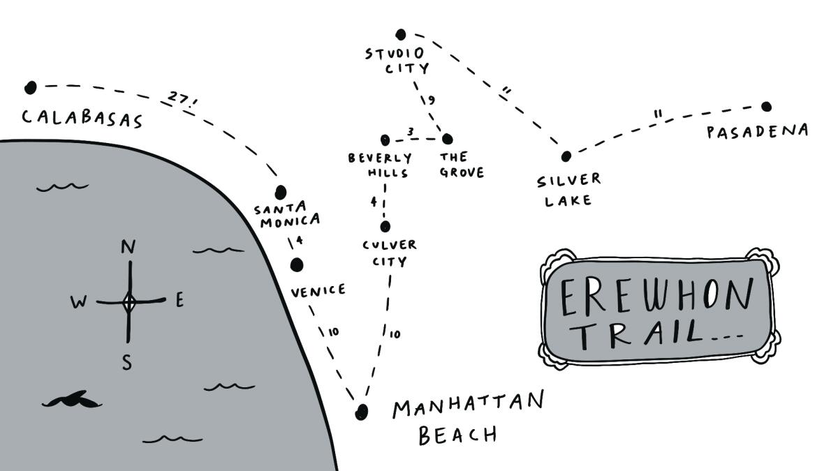
The idea grew as organically as the purple cauliflower at Erewhon. One day, I walked from my place in Los Feliz to the beach. I stopped at two Erewhon locations on the way to refuel. I made a reel about my journey and posted it to Instagram. My friend Fish saw it and said, “You should walk to all the Erewhons.”
I thought: I don’t have time to do that. I’m a very serious person who needs to write her novel.
But later I found myself mapping out an 89-mile hike in my Notes App, starting in Pasadena and ending in Calabasas, stopping at all 10 Erewhon locations on the way. (My route did not include the Palisades, which is closed because of the fires; nor did it include LACMA or the new Glendale locale.)
“I need to write my novel” is a thought I have a lot. I usually heed this thought and sit at the desk like a soldier, imagining the wonderful day when I’ll sell said novel — for an amount that would probably be comparable to a fraction of an Erewhon employee’s yearly salary.
Erewhon Trail map illustration by Swan Huntley.
(Erewhon Trail map illustration by Swan Huntley. )
I really wasn’t in the mood to write the novel, though. When I imagined myself pecking away at the keyboard, I felt bad. When I imagined myself walking around L.A. in my Home Depot gardening hat, I felt good. So, I put on my hat, got into an Uber headed for Pasadena, and texted my sister, “Carpe diem, bitch.” Or at least that was my intention. What I actually sent was, “Carpet diem hitch.”
Over the summer, I hiked a little bit of the Pacific Crest Trail. A few years ago, I biked the Camino in Spain. I’ve walked from Los Feliz to the beach a handful of times. I’ve traversed the length of Manhattan thrice. Before that, when I was a teenager, I used to trek from La Jolla to Del Mar while drinking beer (I carried a cooler; yes, I’m sober now) and listening to Sarah McLachlan on my Discman. I’ve always been drawn to activities that many people find tedious. Like walking forever. Or writing a novel.
Starting in the fourth century, pilgrimages were served up by the church as a way for Christians to pay penance for their sins. They were hard and dangerous and a lot of people died. Fast-forward to now: Such treks have taken on an “Eat, Pray, Love” aura. Or a “Wild “ aura. They live in the realm of self-help and of sport. They’re a way to create friction in an increasingly frictionless world. By walking from Mexico to Canada, or from Erewhon to Erewhon, I wonder whether we’re trying to get back to the part of ourselves that wants to try harder.
Or we just want to become more valuable dinner party guests.
What do you do?
I do really long walks.
I ordered a Goddess Smoothie in Pasadena, and then I repeated this tradition at every store thereafter. The smoothie costs $19, tastes like heaven, and it’s green, which my brain reads as “good for me.”
It took me a little over three hours to walk 11 miles to Silver Lake. I got a Vegan Avocado Sandwich for lunch, took an Uber home and posted a reel on Instagram about my first day on the trail. A lot of people liked it. Some of them called me a genius.
In the last 10 years, I’ve published four novels and two illustrated books for adults. I was naïve and just totally blindly happy about the publishing process in the beginning. People wanted to buy my work? Other people wanted to read it? Cool.
The first book, “We Could Be Beautiful,” did well because the publisher put real money into the marketing of it. Then that stopped happening. At a certain point, I realized that expecting too much was unwise. It was up to me to market my books myself. Which meant: social media.
They say you have to see a book cover six times before you buy the book — or consider buying it. There are a lot of book covers on Instagram. Actually, there’s a lot of everything on Instagram, and out of all the everything, is a book cover that exciting?
No.
My second reel, which depicted my journey from Silver Lake to Studio City, went a little bit viral. To date, almost 10,000 people have shared it with their friends. Why? I think the answer has something to do with a desire for levity.
If the atmosphere of the world could be depicted by an Erewhon beverage, it wouldn’t be a vibrant, cheerful one, like the bright magenta Pitaya Smoothie. It would be the dark and brooding Germ Warfare Shot. I find it perplexing that people talk about the apocalypse as if it’s happening later. It’s happening now. If we were really thinking about how climate change is affecting us, we’d be out in the streets screaming. All the time. But we’re not doing that. We’re carrying on with our usual lives. Apparently, for me, that includes walking to Erewhons.
Any long-distance trek is as much an internal journey as it is external. As I continued the trail, I started to think that maybe my endeavor was a reaction to my feeling of total powerlessness. I can’t save the polar bears. I can’t force the president to go to therapy. But I can add some levity to the brooding atmosphere.
Recently, someone commented on one of the reels, “Transplants make LA locals look bad.” This person, and many others, hear the name Erewhon and assume I’m poking fun at it. Erewhon has become a joke about L.A. — a joke that was amplified after Hailey Bieber invented her smoothie in 2022 that Erewhon dubs the “Strawberry Glaze Skin Smoothie.” I’ve never had it, but I can tell you that it looks like a sky full of strawberry clouds. According to an Erewhon employee I spoke to, this smoothie was a turning point. It aligned the brand with wealth and power. Now, Erewhon evokes the image of smooth-skinned, health-conscious Angelenos with money to burn.
The Erewhon Trail, then, inevitably becomes a conversation about privilege, my own included. Instagram hid my two favorite comments, because it was worried they’d be too rude to show, but I think they’re the funniest ones.
This is what white people do on Prozac.
This is what happens when a liberal arts teacher gets fired.
To both of these comments, I say: Yes.
I’m not on Prozac yet, but maybe after I get fired, I will be.
In order to get fired, though, I’d have to get an actual job, which might never happen.
The most intense leg of the trail was from Santa Monica to Calabasas. My friend Fish joined me. Google said it would take 27 miles. After marching through the mountains, I decided to use my own intelligence to make the route shorter. This cut out four miles, bringing the total to 23. For long stretches, Fish and I walked in the bike lane, or in the bramble by the side of the road. That’s the penalty for straying from Google. Your sidewalks disappear and your chances of getting hit by a car go way up.
My legs were noodles by the time we got to Calabasas. I crawled across the parking lot to show my viewers how weak they’d become. The employee at the door smiled at me and handed me a basket, and I thought about the pain of my legs, which no one could see, and about all the secret battles people are fighting all the time, and I wished that we cared about each other as much as Erewhon cares about us. Multiple employees were perfecting the already-perfect plateaus of bell peppers and apples in the produce section. Their thoughtfulness was the opposite of the vibe I encounter in most public restrooms, which is that the strangers who were there before me didn’t have many thoughts about my experience. As lame as the fact that an Erewhon smoothie costs $19 is that so many of us need to be paid to be nice to each other.
When I tell people about my love for Erewhon, they either say, “Duh, I know,” or something along the lines of, “That place is ridiculous, right?” This is almost always followed by the mention of a food item and some amount of money. Like, “Doesn’t a carrot cost $12,000?”
Actually, I tell them, no. Although sometimes, yes. There is a Japanese strawberry that’s famously expensive ($20), but that’s avoidable. I then explain that contrary to popular thought, there is a way to shop at Erewhon on a budget. A jar of soup, for example, costs $15.50. If you return the bottle, you get $3 back. In my opinion, the soup can be two meals, so that’s $6.25 per meal. A lot of the produce is either the same price or only a little bit more expensive than at other health food stores, and it’s in consistently better shape. The most important piece of making Erewhon more affordable, though, is becoming a member. You get 10% off, a free drink of the month and discounts on a bunch of items.
You might be wondering: How many Erewhon memberships has she personally sold?
She’s lost count.
The other reason to go to Erewhon is the environment. It’s visually appealing and the employee-to-customer ratio is notable, and the result is that you feel like you’re at a resort. And frankly, these simple things — a nice environment, high quality food — should be available to everyone.
Back to the question of whether or not Erewhon is ridiculous — yes, of course it is. If you sit at any of the locations and listen to the conversations around you, you’ll probably feel like you’re an extra in a satirical movie. At Studio City, I overheard two moms in white pants and cashmere sweaters talking about how, based on their Instagram recon, they figured out that so-and-so was sitting next to so-and-so at a benefit dinner. Another snippet I overheard in Studio City: “You gotta make music from the heart, man, and the label will feel it.”
It didn’t occur to me to ask for free merch until after I’d finished the trail. Armando at the Santa Monica location was the lucky recipient of my request. I explained my uniquely heroic feat to him, and then wondered aloud if perhaps I could get a sweatshirt, or at least a hat.
Sadly, Armando was unauthorized to give me merch, but he did offer me a gift card in a tiny envelope. I was very grateful. I assumed the card was worth $50 at least.
After we parted ways, I opened the envelope.
Ten dollars.
Enough to put a down payment on a smoothie.
My dreams now are so different from when I was younger. Back in grad school, I imagined that maybe I’d write a bestselling novel, and maybe it would be adapted for the screen, and maybe my tombstone would read: She contributed very serious literature to civilization.
What I never accounted for was, of course, the unknown. Maybe one day, over a decade after school ended, I’d get a lot of attention for making performance art about walking to grocery stores.
Huntley’s novels include “I Want You More,” “Getting Clean With Stevie Green,” “The Goddesses” and “We Could Be Beautiful.” She’s also the writer/illustrator of the darkly humorous “The Bad Mood Book” and “You’re Grounded: An Anti-Self-Help Book to Calm You the F— Down.” She lives in Los Angeles.
The 67-mile Backbone Trail through the Santa Monica Mountains is a bucket-list trip for many Southern California hikers.
Often, though, it’s hard to carve out time to tackle the whole thing at once. There are limited backcountry camping options, and water can be sparse on the trail. That’s why hikers, myself included, often complete it in sections, similarly to how people will hike the Pacific Crest Trail or Appalachian Trail in segments.
Last week, I ticked off a segment that runs through Latigo, Solstice and Corral canyons that my friends who frequently hike the Santa Monica Mountains have told me is a “must” to try out. I can now see why!
I am eager to share my experience with you and how this hike offers essentially everything there is to love about hiking in the Santa Monicas: incredible ocean views, massive rock formations, native wildflowers and diverse wildlife experiences — all within a short drive from L.A. How lucky are we?
You are reading The Wild newsletter
Sign up to get expert tips on the best of Southern California’s beaches, trails, parks, deserts, forests and mountains in your inbox every Thursday
By continuing, you agree to our Terms of Service, which include arbitration and a class action waiver. You agree that we and our third-party vendors may collect and use your information, including through cookies, pixels and similar technologies, for the purposes set forth in our Privacy Policy such as personalizing your experience and ads.
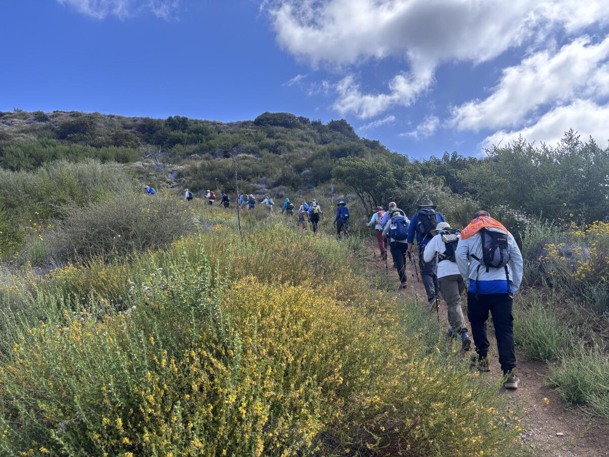
I often hike alone on the weekdays, and I have come to enjoy the solitude. But last week, I hiked a 9.8-mile segment of the Backbone Trail alongside almost 30 other hikers.
Hikers from the Santa Monica Mountains Trails Council’s annual Backbone Trek trudge along the trail.
(Jaclyn Cosgrove / Los Angeles Times)
It is an annual trip organized by the Santa Monica Mountains Trails Council, a volunteer-run group that maintains trails throughout the Santa Monica Mountains and nearby public lands. (The council has regular volunteer opportunities, including three trail workdays this month; RSVP required.)
This was its 21st year to offer the trip at a cost of $625 per person. Trail council volunteers set the route, provide daily hike leaders, set up camp for the group and lug most of the equipment — outside of daypacks, water and snacks — to the group’s next campsite.
The trip usually ends at the eastern terminus of the Backbone Trail in Will Rogers State Park. That area remains closed after the Palisades fire damaged the trail, destroying the Chicken Ridge Bridge. The bridge “is an important link on the [Backbone Trail] and will be the biggest single reconstruction effort for State Parks,” Rachel Glegg of the Sierra Club’s Santa Monica Mountains Task Force wrote last year.
A view from the Backbone Trail around the Newton Canyon area of the Santa Monica Mountains.
(Jaclyn Cosgrove / Los Angeles Times)
I joined the trail council‘s Backbone Trek last Wednesday as an enthusiastic interloper. I showed up late because of horrendous traffic on the 101 Freeway, earning me the trail nickname “Late Edition,” in honor of my punctuality and newspaper job. I felt immediately welcome (and forgiven).
We took a bus from Malibu Creek State Park’s lush group campsite over to the Latigo Canyon trailhead. There is a dirt parking lot there, making it an easy starting point for a day hike.
Our goal was to trek four miles east to the Corral Canyon area, where we’d have lunch among giant rock formations. Shaded by laurel sumac, oak trees and other native plants, we began our journey through the canyons. We were immediately greeted by a resplendence of wildflowers, including purple-pink woolly bluecurls, bright orange southern bush monkey flower, red bursts of cardinal catchfly and at least one Catalina Mariposa lily.
Clockwise from top left: Southern bush monkey flower, Catalina Mariposa lily, keckiella corymbosa and San Bernardino larkspur. Center: Variable checkerspot.
(Jaclyn Cosgrove / Los Angeles Times)
Because I love to dillydally, photographing flowers and taking in the views, I became fast friends with Denise Pomonik, a trail council leader who served as the day’s sweeper, making sure no one got left behind.
Pomonik, who lives in the San Fernando Valley north of the mountains, started volunteering with the council in early 2019 after seeing the 2018 Woolsey fire rip through the Santa Monica Mountains. “The more you hike an area or mountain-bike it, the more personal it gets,” Pomonik said. “I couldn’t control the fire, but I could control what I could do afterward.”
Denise Pomonik of the Santa Monica Mountains Trails Council waves from a large rock formation where the Backbone Trek group had lunch.
(Jaclyn Cosgrove / Los Angeles Times)
The council organizes the annual Backbone Trek not as a fundraiser but instead as a means of creating new land stewards who they hope will fall in love enough with the landscape to want to help protect it, either by donations, volunteerism or activism.
“The more people who fall in love with this mountain range, the more it will be protected,” said Pomonik, who works in the entertainment industry and had no prior trail work experience.
I did not anticipate how expansive the views would be, both of the Pacific Ocean to the south and the nearby peaks, hillsides and valleys to our north. I felt grateful and small.
Chatting with several of the hikers on the trip, I found they had signed up for two main reasons: adventure and healing.
A hiker on the Backbone Trek takes a photo of another as they trek along large boulders and ancient rock formations.
(Jaclyn Cosgrove / Los Angeles Times)
Vidya Oftedal, of Soldotna, Alaska, heard about the trip from a friend who serves on the trails council. Having someone else set up and haul all the gear was the biggest draw for her, she said, because then she could just simply focus on the hiking.
Oftedal, 71, said she loved pushing herself every day on the trip, finding a balance between knowing her limits and learning more about what her body can do.
“I’ve always loved the outdoors,” Oftedal said. “It speaks to me. I feel oneness with nature. Everybody is such an inspiration here. A lot of the women have done solo [trips] … and they’re all seniors like me. It’s like, ‘Wow, maybe I can pick up some courage and do things like that.’”
The camaraderie among the group was easy to see. Although many of them had been strangers just a few days prior, the hikers checked on each other and cheered one another on. After especially steep stretches, we’d pause to catch our breath, and someone would undoubtedly offer snacks to their fellow group members, including roasted fox nuts, or makhana, which the group had become especially taken with.
A raven flies over the rock formation that hikers along the Backbone Trail often say resembles an elephant’s eye.
(Jaclyn Cosgrove / Los Angeles Times)
At lunch, we sat in an area full of large, dramatic rock formations, including one that resembled an elephant’s eye. A few group members perched into small shady alcoves within the boulders. I commented that people had probably been sharing meals together in this area for thousands of years.
I was surprised by how many hikers on the trip were from Southern California but had never visited the Backbone Trail.
I spoke to Bill Edmonds, who told me he’d wanted to tackle the Backbone Trail for years. He grew up in Culver City and around the San Fernando Valley.
Edmonds said he led an active lifestyle, regularly running and skiing, and hiking with his wife, Kathy, who died last June after 51 years of marriage together.
“This has been special,” Edmonds said. “It helped me think about how much she would have enjoyed this.”
A view of the Pacific Ocean from a high point along the Backbone Trail.
I headed out as the group grabbed showers and prepared their taco dinner. I got into my car with a deeper appreciation for what the Santa Monica Mountains can provide us all, along with a few new friends — and a new trail nickname.
3 things to do
Cyclists on a previous Glow Ride hosted by People for Mobility Justice.
(People for Mobility Justice)
1. Illuminate the streets of Florence-Firestone People for Mobility Justice, an L.A.-based transportation equity collective, will host a bike ride from 6:30 to 8:30 p.m. Wednesday starting at Ted Watkins Memorial Park. Riders are encouraged to decorate their bikes with colorful and creative lights for this free Glow Ride through the streets of the Florence-Firestone neighborhood. Register at eventbrite.com.
2. Ascend to new heights in L.A. The Saturday Hike Crew will host a trek at 8:30 a.m. Saturday through Ascot Hills Park. Hikers will ascend steep hillsides to lookout points with sweeping views of L.A. Sturdy shoes are recommended. Register at eventbrite.com.
3. Pack out trash in Fullerton Friends of Coyote Hills needs volunteers at 9 a.m. Saturday to clean up a trail in Fullerton. Participants are encouraged to bring their own gloves and water. You can also bring a trash grabber if you own one. Volunteers should wear sun protection and comfortable sneakers or boots. Register at eventbrite.com.
The must-read
A sign is posted on a eucalyptus tree stating, “Stop killing our trees,” on Glenrose Avenue, where the trees were previously cut down.
(Carlin Stiehl / Los Angeles Times)
Trees in and around the Palisades and Eaton fire burn scars are dying — or being inappropriately removed — at an alarming rate, Times staff writer Noah Haggerty wrote. After a fire, surviving trees in a burn scar often need support, including watering, to survive. Neither city nor county officials prioritized such efforts in the Palisades or Eaton fire scars. Additionally, contractors have removed trees that they were authorized to take down. Builders have also pressured homeowners to cut down trees that they claimed would die anyway, although advocates say native oaks incorrectly identified as dead could have recovered.
It makes me wonder about the fates of trees along hiking trails in the burn scars.
Happy adventuring,
P.S.
Angeles National Forest is home to at least three new ursine residents. Wildlife photographer Robert Martinez documented three cubs following their mom through the forest in late April. Interestingly, the Chaney Trail Corridor Project documented a mama bear and three cubs walking through the foothills of the San Gabriel Mountains near Altadena in early May. I asked them: Could it be the same family? “In theory possible, but unlikely as the locations are more than 20 miles apart,” a volunteer from the Chaney Trail Corridor Project told me via Instagram. “Black bears with young cubs usually keep a smaller home range of just a few square miles. Both families are equally adorable though and about the same size and age!” If this news gives you a bit of the heebie-jeebies, then head over to my article where I explain how to best protect yourself if you encounter a bear while hiking. Be safe out there!
For more insider tips on Southern California’s beaches, trails and parks, check out past editions of The Wild. And to view this newsletter in your browser, click here.
Such is the case with Burney Falls, a Northern California waterfall whose loveliness became such a siren song to costume-wearing Instagram mermaids, selfie-taking TikTok tour guides and off-the-beaten-track road trippers that crowds grew and grew, until the natural wonder just couldn’t handle it any more.
Crowds in recent years have damaged trails, trampled plants and clogged rural roads.
Now, as part of a pilot program to reduce overcrowding, the California Department of Parks and Recreation will require advance reservations to visit the Shasta County waterfall on many days this summer.
“Burney Falls is a crown jewel of the California State Park System, and we want all visitors to have an enjoyable and memorable experience when visiting this one-of-a-kind destination,” State Parks Director Armando Quintero said in a statement. “By allowing visitors to make a reservation in advance, we can help keep crowds manageable and not push the park’s resources past the breaking point.”
The reservations, which can be purchased online, will be required to visit the falls Fridays through Sundays and on holidays during peak visitation season, from May 15 through Sept. 27.
On those days, McArthur-Burney Falls Memorial State Park will offer 103 parking passes for 8 a.m. to noon, an additional 103 passes for 1 p.m. to 5 p.m., and 35 passes for the entire day.
The day use passes will cost $11 per vehicle, according to State Parks, with discounts for seniors and people with disabilities.
California State Parks annual pass holders will pay no additional charge but must make reservations. Visitors with overnight campground or cabin reservations will not need additional passes for day use.
The 129-foot waterfall — a wide curtain of white water cascading from a basalt cliff face — generates its own rainbow and once was dubbed the “Eighth Wonder of the World” by President Theodore Roosevelt.
Visitors often endure long lines to get a selfie at Burney Falls. Here, Rachel Brussbau poses with her 1-year-old daughter, Sage, and Crysten Michol in July 2023.
(Paul Kuroda / For The Times)
But for much of its history, it “experienced limited visitation due to its rural location … and lack of publicity,” the State Parks department said in a statement.
“For generations of visitors, it had the reputation of a small, family-oriented park and one of California’s best-kept secrets,” the department said. “However, over the past decade, and especially with the growth of social media, that secret is now world-famous.”
Crowds swelled during the COVID-19 pandemic, when indoor public spaces closed.
A State Parks spokesperson told The Times in an email Monday that in 2015, Burney Falls had 121,495 visitors. Numbers “have steadily risen since that time, peaking at 322,192 visitors in 2020 during the pandemic,” the spokesperson said.
Since then, about 220,000 people have visited the park each year.
The spokesperson said the numbers account only for people who come in through the official entrance and not those who park illegally on the side of the road and enter off-trail.
Because so many people have veered off established trails, the park in recent years has experienced increased erosion and damage to sensitive vegetation and sacred tribal land, according to the State Parks department. Heavy traffic and illegal parking also have created unsafe conditions along State Highway 89, one of the heavily forested county’s main thoroughfares and a critical fire evacuation route.
“Campers with reservations are hesitant to leave the park, knowing that it may take up to two hours to re-enter on busy days,” the department statement read.
Because of limited parking, the gates often close for several hours each day.
“If lucky enough to gain entry, visitors inside the park are met with extreme overcrowding, long restroom lines, and overflowing trash cans instead of a peaceful, rejuvenating experience at one of the nation’s most awe-inspiring natural landmarks,” State Parks said.
In the summer of 2024, State Parks closed all access to the waterfall for the season to repair trails and slopes damaged by heavy crowds and storm erosion.
The department said it will evaluate the day use reservation system at the end of the summer and make adjustments if necessary for future peak visitation periods.
State Sen. Megan Dahle (R-Bieber), whose district includes Shasta County, said the pilot program “is likely to disrupt some trips” until word spreads.
“Unfortunately, for several years it has been clear something needs to change at Burney Falls,” Dahle said. “I hope this is an interim measure on the way to longer-term fixes to accommodate visitors.”
Up here, the river was a mere gurgle; a babbling babe finding its way into the world. A few sheep roamed, a kite wheeled and a spring-clean wind ruffled the tussocks on the barren hills and rippled the pools. It was a stark yet striking beginning. As we followed a brand new fingerpost, skirted Llyn Teifi – the river’s official source – and picked up the fledgling flow, there was a sense great things lay ahead, for us both.
The Teifi rises in Ceredigion’s Cambrian Mountains – the untramped “green desert of Wales” – and pours into Cardigan Bay 75 miles (120km) south-west. It’s one of the longest rivers wholly within Wales and, historically, one of its most significant: the beating heart of the country’s fishing and wool-weaving industries, 12th-century abbeys at either end, Wales’s oldest university en route.
However, those abbeys lie in ruin now, salmon and sewin (brown trout) stocks have plummeted, and the mills are shuttered – though the factory in the village of Dre-fach Felindre now operates as the National Wool Museum. Even the future of Lampeter’s venerable university is uncertain following the decision to end undergraduate teaching there. It’s as if the valley has lost its purpose. So some determined local walkers are giving it a new one.
Teifi Pools – the start of the walk. Photograph: CW Images/Alamy
The Teifi Valley Trail, an 83-mile hike following the river from source to sea, officially launched on 25 April, but has been decades in the making. The idea was born back when Ceredigion, Pembrokeshire and Carmarthenshire came under one authority (Dyfed), said Kay Davis of the Teifi Valley Trail Association (TVTA), when we met in Llanybydder. “Then the three counties separated in 1996 and it went off the boil. A long time later, we thought, wouldn’t it be great if there was a trail? So we got together with others in the area and went from there.”
It has been a grassroots, cooperative effort between members of local Ramblers groups, Walkers are Welcome communities and footpath associations along the valley, working to reopen paths, secure permissions, nail up waymarks and create a guide. Thought has been given to route quality, places to stay and accessibility by public transport.
“One of the main reasons for the trail is to get people with backpacks and boots down here to spend money,” added the TVTA’s James Williams. “We’ve seen the economic effect the coastal paths have; we thought we could have a bit of that as well.” Backpacked and booted, my husband and I were here to give it a go.
There’s certainly something powerful about following a river. Walking from Teifi Pools on our first day, that trickle led us across the moor and through wild, wooded valleys or cwms with the exuberance of youth. It soon took us to Strata Florida, the abbey founded in 1164 by Cistercian monks seeking solitude in nature – not to mention access to the area’s abundant timber, pasture, peat, lead ore and, of course, water. Little remains of the abbey now – a grand arch, some fine medieval tiles, a cottage housing a small but fascinating exhibition. But this was once the Westminster Abbey of Wales, second only in fame to St Davids and much larger than the ruins suggest. Many pilgrims made the journey here.
Walking beside the Teifi River between Llechryd and Cilgerran. Photograph: Sarah Baxter
Most have probably never heard of Strata Florida, and the Teifi Valley continued in this vein: a place of secrets and little-heard stories. These ranged from a buried elephant (behind Tregaron’s handsome Y Talbot Hotel, allegedly) to dry-stone walls built by Napoleonic prisoners of war. Llanddewi Brefi village was full of tales. On the old mountain-crossing drovers’ route, it has a soaring Norman church built on a mound said to have been miraculously raised by St David himself. These days, Llanddewi is better known as the scene of an enormous LSD drugs raid in 1977 or as the home of Little Britain’s “only gay in the village”. “Most here didn’t watch the show, and I didn’t mind it,” said Yvonne Edwards, landlady of Llanddewi’s New Inn, a proper no-frills-and-flagstones pub. “It was just annoying, having Australian journalists ringing in the middle of the night, and people stealing road signs.”
Further down the trail, just outside Llanybydder, we found one of Davis’s hidden gems: a woodland path, long unused, that her Ramblers group worked hard to reopen. “It’s tiny,” she’d told us, “but there’s a presence there, a good presence.” Indeed, it was like a shot of Narnia, a short stretch of moss-covered magic.
Over the following days, we flirted with the river. At times we were high above, peering from gorse-covered hill forts, across slopes of sheep-grazed green or through woods flush with bluebells. At others, we were on its banks, once close enough to glimpse an otter raise its silken head in the swirl. Beyond Llechryd, the path squeezed us through a tree-huddled gorge, the river’s murmurings joined by the gossip of thrushes, tits, blackcaps and wrens.
The general mood was soothing. It was hard to imagine this river roisterous with industry, fizzing with fish, busy with boats – Cardigan, within the Teifi’s tidal reach, was once the second-largest port in Wales. It’s a quieter town these days, and looking good, boosted by the restoration of its castle, which was rescued from ruin a decade ago. The castle hosted the first National Eisteddfod in 1176; in celebration of the 850th anniversary, the 2026 festival is being held at nearby Llantwd.
St Dogmaels, Pembrokeshire, in the estuary of the Teifi. Photograph: Ceri Breeze/Alamy
We stayed in one of the castle’s refined rooms, but still had a few miles to go to reach journey’s end. The trail runs via St Dogmael’s Abbey and climbs high for views across the estuary before dropping to meet it at sweeping Poppit Sands. We washed our boots in the shallows, “our” river now indiscernible, swallowed by the sea.
It was a good walk. And perhaps it wasn’t over? “Early on, we had this idea to create the Celtic Circle,” Davis told me: a 175-mile loop linking the Teifi Valley Trail, a section of Wales Coast Path to Borth, and the Spirit of the Miners route from Borth to Strata Florida. “But we’ll see if we still have the energy after this!”
It was my first time hiking through Tilden Regional Park, a 2,079-acre wooded hilly expanse near Berkeley, and I was looking for one very specific thing: a small red, white and blue rounded triangular trail marker with a tiny map of the United States.
I’d already struck out twice, parking at the wrong trailheads, and I was really hoping the third time would be the charm. I trudged up the Upper Big Springs Trail, a wide dirt path lined with fragrant eucalyptus, pine trees and California bay laurels and, peeking out of the invasive grasses, California poppies and orange bush monkey flower.
I crested a hill after about two-thirds of a mile, and there I saw a sign, both literal and metaphorical, on a small brown post letting me know I was exactly where I needed to be. I was officially hiking along the American Discovery Trail, a contiguous 6,800-mile coast-to-coast nonmotorized route of multiuse trails that runs from Point Reyes National Seashore in Marin County to Cape Henlopen State Park in Delaware.
The American Discovery Trail sign in Tilden Regional Park near Berkeley.
(Jaclyn Cosgrove / Los Angeles Times)
“The ADT is all about connections — people to people, community to community, urban areas to wilderness,” according to a website outlining its history. “… The ADT connects five National Scenic, 12 National Historic, and 34 National Recreational Trails; passes through urban centers like Cincinnati and San Francisco; leads to 14 National Parks and 16 National Forests” and visits thousands of historic, cultural and natural sites.
I’m excited to share not only about the joy that can be found along this route, but also how you can join a relay in July across America along the trail. I certainly plan to!
You are reading The Wild newsletter
Sign up to get expert tips on the best of Southern California’s beaches, trails, parks, deserts, forests and mountains in your inbox every Thursday
By continuing, you agree to our Terms of Service, which include arbitration and a class action waiver. You agree that we and our third-party vendors may collect and use your information, including through cookies, pixels and similar technologies, for the purposes set forth in our Privacy Policy such as personalizing your experience and ads.
I’d never heard of the American Discovery Trail until last week when I attended the California Trails & Greenways conference in San Ramon. There, I met with American Discovery Trail co-founder John Fazel and John Mercurio, the trail’s California coordinator, to learn more.
The idea to create a coast-to-coast trail was born out of a 1980-81 hike across America called “HikaNation,” where several members of the American Hiking Society trekked more than 4,000 miles across the country. That adventure inspired Backpacker magazine and the American Hiking Society in 1989 to start developing the American Discovery Trail.
A view of the San Francisco Bay from the Seaview Trail in Tilden Regional Park near Berkeley. The route is a part of the American Discovery Trail.
Then, in 1991, the American Hiking Society hired a national coordinator to work with volunteer state coordinators to develop the route, and in 1996, trail advocates formed the American Discovery Trail Society to ensure their dreams became a reality.
“It’s an opportunity to get to know America up close and personal and not as a flyover,” said Fazel, who grew up in Iowa.
The San Pablo Reservior as seen from Tilden Regional Park near Berkeley.
(Jaclyn Cosgrove / Los Angeles Times)
Most people don’t complete the trail in one trip, Fazel said, as it takes months to finish and requires participants to leave the East Coast around February to ensure that enough snow has melted by the time they reach the mountains in Colorado and California.
Although the trail has existed for several years, Fazel and Mercurio admit that they don’t know exactly how much of the route is a recreational trail, sidewalk or roadway. That’s in part because it’s a technically complicated task to complete, especially for a mostly volunteer group. But it’s also because the route is ever-evolving (which is actually exciting).
“Since we got involved, small towns, counties, even states are funding millions of dollars to build trails in their area, and when they see a national trail goes across the country, they want to connect to it, and when they do, where it is on back roads, we can move it off,” Fazel said. “And it happens.”
A labyrinth in Tilden Regional Park along the American Discovery Trail.
(Jaclyn Cosgrove / Los Angeles Times )
In California, the only place hikers are on pavement for a significant amount of time is from the Antioch Bridge north to Sacramento as they travel through the Sacramento-San Joaquin Delta, Fazel said.
Mercurio said he is working with local officials to try to move the trail from this narrow roadway onto an old railroad track that’s owned by the state.
“It’s been sitting there vacant for many, many years,” Mercurio said. “Now, they should know that there’s this national trail, this coast-to-coast trail, [that] is interested in utilizing that to provide a safe way for us to make our way across the delta.”
Unlike the Pacific Crest Trail, Appalachian Trail and other multistate routes, the American Discovery Trail is not federally designated under existing law.
The National Park Service studied the American Discovery Trail in the mid-’90s and acknowledged that the American Discovery Trail doesn’t fit neatly into any of the existing categories outlined in the National Trails System Act, Mercurio said. The agency mapped out three options for Congress to consider, including creating a new category for discovery trails, he said.
A lush tree canopy along the Seaview Trail, part of the American Discovery Trail, in Tilden Regional Park.
(Jaclyn Cosgrove / Los Angeles Times)
Trail advocates have been pushing Congress for more than 25 years to create such a category. They came close in 2021 when U.S. Rep. Mark DeSaulnier (D-Concord) introduced such legislation that garnered 63 co-sponsors.
“We had people on the House resources committee who were far right and killed it,” Fazel said, adding the trail has otherwise garnered bipartisan support for decades in states it passes through.
There was a mix of suspicion and concern that the recognition of the trail would lead to eminent domain and requests for federal money, neither of which the trail’s organizers want, Fazel and Mercurio said.
“The thing is, we don’t build any trail at all,” Mercurio said. “All we do is route onto stuff that’s already there, and our presence influences local jurisdictions to create trail that would be good for our route. But they’re in this anti-federal feeling, so they just knee-jerk don’t want to support it.”
The Golden Gate Bridge as seen from Tilden Regional Park.
(Jaclyn Cosgrove / Los Angeles Times)
The duo remains optimistic that their trail will get national recognition. In the interim, they’ve got other big plans.
On July 1, as long as everything goes according to plan, the American Discovery Trail Society will launch its “America 250 Relay,” aiming to cross the Golden Gate Bridge by July 4 and ending in Delaware at the Atlantic Ocean on Thanksgiving Day.
Anyone can join to traverse the trail in a people- or horse-powered way. Participants will carry a copy of the Declaration of Independence in a celebration of America and the outdoors. (I’ve already texted two best friends to entice them to do part of the relay with me!)
A flax-leaved blue pimpernel in Tilden Regional Park.
(Jaclyn Cosgrove / Los Angeles Times)
In a time of rising authoritarianismacross the globe, it’s important we seek both joy and connection, focusing less on what we’re fed by algorithms and more on our shared humanity. I know that sounds fairly Pollyanna, but especially as a transgender American who constantly worries about whether I can safely visit my family in the Midwest, where lawmakers are seemingly seeking to outlaw my existence, I do actually mean it.
As I neared the end of the trail, a golden Labrador retriever greeted me, and after lots of head scratches, I met the dog’s owner. He and I started chatting, and soon realized that, although we belonged to different generations, we had both grown up as farm kids.
He started to tell me the story of when his dad ran himself over with a tractor.
“My dad ran himself over with a tractor too!” I said. “Did your dad start the tractor from the ground even though he’d told you a million times as a kid not to?”
“No, but he did try to get off and get back on a moving tractor,” he said, which my new friend’s father had repeatedly told him not to do.
I didn’t expect to discuss tractors and hay bales with a stranger in the East Bay, but I found that these experiences are a part of what the American Discovery Trail provides.
3 things to do
A human and canine guest travel along a previous CicLAvia event route.
(CicLAvia Los Angeles)
1. Wander the car-free streets of West L.A. CicLAvia, an L.A. nonprofit, will host a free three-mile, car-free open streets event from 9 a.m. to 4 p.m. Sunday through West L.A. The event marks the 65th open streets event the organization has held around L.A., but it’s the first time that one has been held in West L.A. The route includes portions of Santa Monica and Westwood boulevards. Attendees are invited to traverse the route in any people-powered device, although there are certain restrictions on e-bikes. Learn more at ciclavia.org.
2. Prop up the pollinators in Castaic TreePeople will host Pollinator Palooza from 9 a.m. to 1:30 p.m. Saturday at Castaic Lake. Volunteers will plant milkweed and restore habitat. The event will also feature plant giveaways, an environmental resource fair and a pollinator-themed fashion show. Learn more at treepeople.org.
3. Orient yourself in Irvine Save Orange Hills and Naturalist For You will host a hike, yoga and meditation event from 8 to 10 a.m. Sunday at Irvine Regional Park. After a short warm-up hike, guests will take part in an all-levels yoga session. Tickets are $17.85, but no one will be turned away due to lack of funds. Register at eventbrite.com.
The must-read
San Joaquin River Parkway, currently operated by the San Joaquin River Conservancy, would join various properties into an 874-acre state park, expanding recreation opportunities and greater access along the river. The park would complement nearby Millerton Lake State Recreation Area.
(California State Parks)
California could soon see the development of three new state parks in the Central Valley. State officials announced the proposed parks on Wednesday, which are Feather River Park in Yuba County, San Joaquin River Parkway near Fresno and Dust Bowl Camp in Bakersfield, Times staff writer Hayley Smith wrote. State officials also aim to expand three existing parks in Mendocino County, Nevada County and San Mateo County. “California’s state parks are nothing short of iconic — with locations like Big Sur, Southern California beaches, and the world’s tallest trees — but our state has even more to offer,” said Wade Crowfoot, California’s natural resources secretary.
Happy adventuring,
P.S.
Hikers and trail builders have until April 30 to complete the California Trails Survey, which state officials will use to help shape how nonmotorized recreational trails are developed in the state — and how officials use millions from Prop 4, often called the “climate bond” because its money is supposed to be spent to combat climate change. The survey includes two portions, one for trail users and another for trail builders and advocates. If you fit both categories, you are invited to complete both portions. Early data, released at a trails conference I attended last week, suggested that white hikers were overrepresented in the results, so please spread the word, especially to BIPOC hiking organizations in your area!
For more insider tips on Southern California’s beaches, trails and parks, check out past editions of The Wild. And to view this newsletter in your browser, click here.