I love Loch Lomond in autumn. I’d start with a walk around Balmaha village and a stretch of the West Highland Way, pretending I’m there for the scenery rather than earning the right to eat something massive afterwards. Autumn is when it looks best: orange hills, cold air, dramatic clouds and the constant Scottish gamble of whether you’ll get sunshine, sideways rain, or both within 10 minutes. I finish, if I’m not driving, with a wee dram to properly round things off. Pete
Cornwall’s wild autumn seas
The coastal path from Godrevy. Photograph: Peter Lane/Alamy
The rough beauty of Cornwall’s sea views appeals to me. A great autumn day involves walking along the staggered cliff edges between Godrevy and Portreath. The isolated nature of the coastal paths makes me feel as if the sea is singing just for me, while below the waves go wild, waiting to be admired. On this walk, you will be rewarded with the most breathtaking views, lone benches and burnt orange sunsets. Oliwia
A hydro-powered house in Northumberland
Cragside was a technological marvel of the 19th century, with hydroelectric power and hydraulic gadgets. Photograph: Jonathan Ayres/Alamy
When I first visited the National Trust’s Cragside in Northumberland, a staff member at the entrance made the bold claim that it was “the best place in England”. In autumn you can really see their point. The estate’s 1,000 acres are covered with a huge variety of trees that transform the landscape into a mixture of reds, oranges and deep greens, contrasting perfectly with the often misty Northumberland weather. It’s a perfect autumn day trip for woodland walks, possibly stopping for a picnic at one of the many lakes or gardens, and visiting the extraordinary hydro-powered Victorian house with its pioneering gadgets. Everly
Profile
Readers’ tips: send a tip for a chance to win a £200 voucher for a Coolstays break
Show
Guardian Travel readers’ tips
Every week we ask our readers for recommendations from their travels. A selection of tips will be featured online and may appear in print. To enter the latest competition visit the readers’ tips homepage
–
– back sections make it manageable without losing the drama. Bonita Philp
Deep in the forest in the Scottish Borders
Lichen on fir trees in the Glentress Forest. Photograph: Tom Richardson Scotland/Alamy
Glentress Forest in the Scottish Borders is hard to beat on a crisp autumn day. Start with a walk or mountain-bike ride through the forest, when the trails are surrounded by copper, red and gold, and climb high enough for brilliant views across the Tweed valley. Afterwards, warm up with coffee and something sweet at the cafe before heading into nearby Peebles for a wander along the river and around its independent shops. It feels properly remote despite being less than an hour from Edinburgh. And, whether you’re cycling or walking, autumn is when the forest is at its most spectacular. Remi Lapeyre
Birmingham’s secret oasis
Winterbourne Gardens. Photograph: Michael Kemp/Alamy
Winterbourne House and Garden at Birmingham University is a wonderful little oasis in Edgbaston, just outside the city centre. A beautiful Arts and Crafts style house, set in stunning gardens, it is a lovely place for a wander and is especially beautiful on a sunny day in early autumn when everything is golden. See herons at the reservoir, talk to friendly robins by the walled garden and browse the bookshop. Have coffee there and then head into nearby Harborne for lunch or dinner. Rachel
Rivers and ruins in a Lancashire valley
The River Roddlesworth near Darwen. Photograph: Walker/Alamy
Rocky Brook is the name given by locals to the River Roddlesworth, which flows through a wonderful wooded valley at the edge of the West Pennine Moors. The woodland, planted by Liverpool Corporation Waterworks, provides plenty of autumn colour. A network of paths allows exploration of the woods and the ruins of Hollinshead Hall and well house. There’s a public car park, cafe and pub (the Royal Arms) at Ryal Fold, and for those who walk north-west through the woods there’s also the Hare & Hounds at Abbey Village. Four buses a day run from Blackburn to the Royal. Graham Dean
Sessile oaks in Padley Gorge. Photograph: Septemberlegs/Getty Images
The Longshaw estate in the Peak District is perfect for an autumn stroll. Both Oaks Wood and Bolehill Quarry have a huge variety of fungi in their hidden depths. The twisted oak trees in Padley Gorge look at their most spectacular on early autumn misty mornings. It’s easy to explore pathways on the estate with the friendly free social walk every Wednesday. Finish a wonderful day with a treat in the cafe. Katharine
A lime tree avenue in Nottinghamshire
Clumber Park’s avenue of trees is one of the longest in Europe. Photograph: Eye35 Pix/Alamy
Clumber Park is a must-visit at this time of year. The National Trust property features peaceful woodlands with golden leaf carpets, crisp lakeside views and an ornamental bridge. You’ll want to keep your camera handy as you enter a double tree avenue of 1,296 limes stretching three miles (one of the longest in Europe), which provides a gorgeous golden canopy. The walled kitchen garden is a favourite with its massive apple collection and seasonal displays. The apple juice I’ve tried here is some of the best I’ve tasted. Asma
A Roman autumn at Hadrian’s Wall
Late autumn at Steel Rigg. Photograph: Donaleen Shiell/Alamy
My perfect autumn day is walking Hadrian’s Wall from Steel Rigg, when the moorland turns copper and gold and every climb rewards you with another enormous Northumberland view. Pack a flask, sturdy boots and something waterproof – the weather changes its mind even faster than I do. You only pay for parking, and shorter out- and
Winning tip: Steaming through north Wales
The Llangollen Railway. Photograph: Paul Weston/Alamy
My perfect autumn day out is a trip on the Llangollen Railway in north Wales. There’s something magical about travelling through the Dee valley on a steam train when the leaves have turned orange and gold. We start in Llangollen, grab something warm to drink, then climb aboard for the journey alongside the River Dee, watching the autumn scenery through the window. Afterwards, we wander around Llangollen, exploring the little shops. It’s simple, nostalgic and feels like autumn properly arriving – especially when you hear the steam train whistle through the valley. Chelsea
Nurse Agimol Pradeep – Aster Guardians Global Nursing Award 2026 WinnerBusiness Wire
Article content
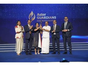
KOCHI, India — From more than 134,000 registrations spanning 214 countries and economies, Nurse Agimol Pradeep from United Kingdom has been announced as the winner of the Aster Guardians Global Nursing Award 2026. A Senior Transplant Coordinator at King’s College Hospital and Honorary Senior Lecturer at the University of Salford, UK, she was recognised with USD 250,000 at a prestigious ceremony held in Kochi, India.
THIS CONTENT IS RESERVED FOR SUBSCRIBERS ONLY
Subscribe now to read the latest news in your city and across Canada.
Exclusive articles from Barbara Shecter, Joe O’Connor, Gabriel Friedman, and others.
Daily content from Financial Times, the world’s leading global business publication.
Unlimited online access to read articles from Financial Post, National Post and 15 news sites across Canada with one account.
National Post ePaper, an electronic replica of the print edition to view on any device, share and comment on.
Daily puzzles, including the New York Times Crossword.
SUBSCRIBE TO UNLOCK MORE ARTICLES
Subscribe now to read the latest news in your city and across Canada.
Exclusive articles from Barbara Shecter, Joe O’Connor, Gabriel Friedman and others.
Daily content from Financial Times, the world’s leading global business publication.
Unlimited online access to read articles from Financial Post, National Post and 15 news sites across Canada with one account.
National Post ePaper, an electronic replica of the print edition to view on any device, share and comment on.
Daily puzzles, including the New York Times Crossword.
REGISTER / SIGN IN TO UNLOCK MORE ARTICLES
Create an account or sign in to continue with your reading experience.
Access articles from across Canada with one account.
Share your thoughts and join the conversation in the comments.
Enjoy additional articles per month.
Get email updates from your favourite authors.
THIS ARTICLE IS FREE TO READ REGISTER TO UNLOCK.
Create an account or sign in to continue with your reading experience.
Access articles from across Canada with one account
Share your thoughts and join the conversation in the comments
Enjoy additional articles per month
Get email updates from your favourite authors
Sign In or Create an Account
or
Article content
Article content
Since its launch in 2021, the Aster Guardians Global Nursing Award has grown into a global platform that celebrates nurses who are advancing the profession and creating meaningful change. The award was presented by Shri V. D. Satheesan, Hon’ble Chief Minister of Keralam, in presence of Dr. Azad Moopen and Alisha Moopen. The ceremony also featured a special message from Dr. Tedros Adhanom Ghebreyesus, Director-General of the WHO, applauding Aster’s role in celebrating the contributions of nurses worldwide.
Article content
Article content
Top Stories
Get the latest headlines, breaking news and columns.
By signing up you consent to receive the above newsletter from Postmedia Network Inc.
Thanks for signing up!
A welcome email is on its way. If you don’t see it, please check your junk folder.
The next issue of Top Stories will soon be in your inbox.
We encountered an issue signing you up. Please try again
Article content
Nurse Agimol Pradeep
Article content
Article content
“I am deeply honoured to receive the Aster Guardians Global Nursing Award. I hope to use this opportunity to expand organ and stem cell donation, while empowering nurses and strengthening the global nursing workforce to drive lasting change.”
Article content
Dr. Azad Moopen, Founder Chairman, Aster DM Healthcare
Article content
Article content
Article content
“
Article content
Nurse Agimol Pradeep’s achievement embodies the expertise, courage, compassion and unwavering commitment that define exceptional nursing. These are the qualities at the heart of the Aster Guardians Global Nursing Award, which was established to recognise and elevate the vital contributions of nurses worldwide.”
Article content
Alisha Moopen, Managing Director and Group CEO, Aster DM Healthcare
Article content
Article content
“
Article content
Nurse Agimol has shown us that meaningful change can begin anywhere through a single nurse determined to solve a problem. Stories of our top 10 finalists demonstrate that nurses are not only essential to delivering healthcare; they are shaping how healthcare evolves.”
Article content
About Aster DM Healthcare:
Article content
Founded in 1987 by Dr. Azad Moopen, Aster DM Healthcare is a leading integrated healthcare provider, with a strong presence across seven countries. Aster is committed to the vision of providing accessible and high-quality healthcare, from primary to quaternary services, with its promise of “We will treat you well.”
SAN FRANCISCO: Saudi Arabia is building an integrated model to attract leading artificial intelligence companies and help them expand globally, Communications and Information Technology Minister Abdullah Al-Swaha said in Silicon Valley on Friday.
Speaking at the fourth edition of the Frontier Leaders Forum 2026, held under the theme “AI Forward: A Global Frontier,” Al-Swaha said the Kingdom’s approach was centered on providing AI companies with three key resources: computing capacity, capital and access to customers.
Al-Swaha said the Kingdom aimed to build on that experience and attract more global AI companies. (SPA)
He cited Grok as an example of this approach, highlighting Saudi Arabia’s partnership with US AI company xAI and Saudi AI company Humain to deploy Grok in the Kingdom and develop large-scale AI computing infrastructure.
Al-Swaha said the Kingdom aimed to build on that experience and attract more global AI companies, the Saudi Press Agency reported.
Saudi Arabia is working with the private sector to develop more than 14 gigawatts of computing capacity, he said, providing infrastructure for advanced AI companies while helping reduce operating costs and improve efficiency.
Al-Swaha also highlighted the Kingdom’s expanding use of generative AI, AI agents and augmented-reality applications across sectors including healthcare, government services, transportation and logistics. (SPA)
Humain is developing a range of AI infrastructure and platforms in the Kingdom, including AI cloud and high-performance computing services designed to support training, fine-tuning, inference and other AI workloads.
Al-Swaha also highlighted the Kingdom’s expanding use of generative AI, AI agents and augmented-reality applications across sectors including healthcare, government services, transportation and logistics.
He said Saudi Arabia would continue working with Silicon Valley around talent, technology and trust while providing the computing capacity, customers and capital needed to help the next generation of AI companies scale internationally.
Al-Swaha held a series of meetings during his visit with technology and investment executives to discuss expanding AI investment in the Kingdom, developing advanced models and applications and integrating them with infrastructure and computing capabilities being developed by Humain.
He met General Catalyst’s CEO Hemant Taneja to discuss expanding the investment firm’s AI and advanced-technology activities in Saudi Arabia, enabling its portfolio companies to develop and deploy applied AI solutions and using Humain’s computing capabilities to accelerate implementation in priority sectors.
A further meeting with Velaura AI’s co-founder and CEO Rajiv Khemani focused on integrating energy-efficient computing technologies. (SPA)
Al-Swaha also met Arcee AI’s founder and CEO Mark McQuade to discuss expanding the use of the company’s Trinity open and enterprise models and deploying them across Humain’s infrastructure.
He held talks with Engramme’s co-founder and CEO Gabriel Kreiman on AI memory and continuous-learning applications designed to allow organizations to build models that learn from their own data, knowledge and operating environments.
Infrastructure was another focus of the meetings. Al-Swaha met Supermicro’s founder and CEO Charles Liang to discuss AI factory solutions, including integrated systems, liquid cooling and high-density architectures aimed at improving energy efficiency and supporting large-scale AI data centers.
He also met Upscale AI’s CEO Barun Kar to discuss high-performance AI networking and improving connectivity between computing accelerators, memory and storage to maximize the use of computing resources.
A further meeting with Velaura AI’s co-founder and CEO Rajiv Khemani focused on integrating energy-efficient computing technologies into Humain’s infrastructure and supporting the expansion of AI applications and autonomous systems.
DUBAI: Saudi Arabia’s foreign minister, Faisal bin Farhan, said on Tuesday the Kingdom will not hesitate to defend itself against Houthi attacks.
Speaking from Russia’s capital, the minister said the Kingdom would use all available means to protect its interests.
“Houthi militia resorts to violence whenever it finds itself in a difficult situation. The Houthis are trying to export their domestic problems inside Yemen to Saudi Arabia,” he added.
The minister said the door for diplomacy was open for the Houthis but that they resorted to violence whenever they found themselves in a difficult situation.
Russian FM Sergey Lavrov said Houthi attacks on civilian targets in Saudi Arabia were unacceptable.
“Security and freedom of navigation in the Bab el-Mandeb Strait must be ensured,” he added.