I headed down to East Sussex to undertake the hike crowned as Britain’s most beautiful and ‘eye-catching’ trail — then everything went wrong.
This article contains affiliate links, we will receive a commission on any sales we generate from it. Learn more
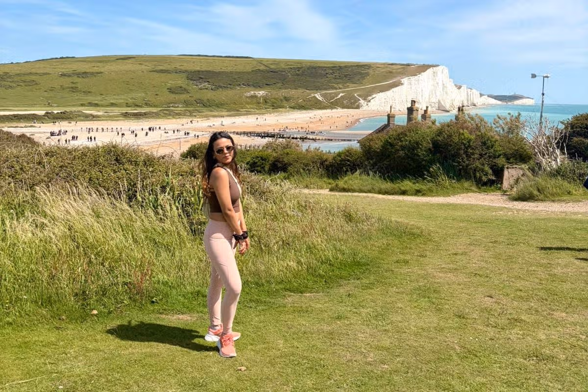
The stunning views left me speechless(Image: Parul Sharma)
A hiker I am not. But when my husband told me the only thing he wants for his birthday this year is to be outdoors and go for a hike – a hiker I became. Begrudgingly.
The location for my (destined to be comical) exploits? The Seven Sisters Cliff Walk in East Sussex. ‘Walk’ being an under exaggeration.
Fair disclaimer before you read on – this story is basically a 900-word ode to my unsurpassable levels of fitness. *Cue Rocky theme song*
Whether I would be a picture of grace or not, at least the destination we picked was sure to be stunning, having recently been named one of the most beautiful and ‘eye-catching’ hiking trails in the world.
The new study by online running shoe retailer SportsShoes.com assigned each hiking trail an ‘eye-catching’ score using eye-tracking technology, ultimately giving us the world’s top 10 most beautiful hikes. The Seven Sisters Cliff Walk ranked ninth on the list.
We set off for the hike on what somehow turned itself into a glorious day amidst an endlessly rainy week and fervently thanked our stars for big little mercies. Then we missed our train and the order of the universe was restored.
We eventually made it to our seaside destination of Seaford – an hour and a half after the initial expected arrival – and set off on our hike. The wind was knocked out of my lungs the second my eyes gazed upon Britain’s most famous chalk cliffs. They were eye-catching alright.
Having done my due diligence much in advance, I had already been informed by countless reviews online that the ‘cliff walk’ was easy to moderate difficulty. Each and every one of the reviews was a lie. The difficulty level was hard, high, expert, nightmare.
The very first hill ascent left me winded, and when I reached the top of the ‘first’ sister of the Seven, I looked at my husband and called an emergency meeting. I loved him and happy birthday, but we would be taking shortcuts.
One look at my red, panting face and he quickly agreed, lest our outdoorsy hike turn into an emergency room visit. Good call on his part.
While I’m on this self-flagellating shame-spiral, it’s probably a good time to mention that I danced at an almost professional level for over a decade of my life. That girl was nowhere to be seen on this hike.
After taking a few embarrassing pauses while fit-as-hell pensioners passed me by, we finally descended the first hill, made our way to Cuckmere Haven, and braced ourselves for our next adventure (read: obstacle), The River Crossing.
With an unspoken agreement passing between us not to take the detour, my husband and I made our way to the flowing stretch we had to cross, and silently began taking off our shoes and socks. Nothing would stop me from undertaking this adventure (except for a very strong current, or really high water, or too much of a crowd – you get the gist).
Jokes aside, it was the part of the hike I was most excited about, so I was crossing this river come hell or high water. Pun intended and all that.
Holding onto each other for dear life, we made our way across the (extremely sharp and pointy) rocky river crossing and finally collapsed on the other side. It may well have been the most memorable, and fun, part of the hike. Would I do it again? Probably. Would I moan and whine doubly throughout? Definitely.
At that point it was time for a well-deserved pint, so off we headed towards the Cuckmere Inn for a scrumptious birthday lunch. After devouring my first ever Sunday Roast and finishing it off with a banoffee cheesecake, the greatest hiker in the world, aka me, got ready for the second leg of our ‘cliff walk’.
A short bus ride to Birling Gap later, we were back at the foot of a daunting cliff, and I, once again, questioned my commitment to our vows as I begrudgingly made my way up another hill that was not ‘easy’ or ‘moderate’ to climb.
Like the Big Bad Wolf in Three Little Pigs, I huffed and puffed my way up towards the Belle Tout Lighthouse, which, spoiler alert, was not pretty enough to be the reward for this monster mountain I had just climbed.
Another descent and one more seemingly endless and exhausting descent later, we got our first glimpse of the Beachy Head Lighthouse and clifftop and all was forgiven.
After spending an adequate amount of time ooh-ing and ahh-ing over the stunning, drop-dead gorgeous beauty we were surrounded by, we made our way towards The Beachy Head pub for our final pint (Pimms for me) of the day.
As the sun finally began to set on the day, we started walking towards the bus stop that would take us to Eastbourne Station so we could catch our train back to London.
It was on this walk that I began to realise something was horribly, terribly wrong. My entire right foot began feeling taut and stiff, and the shooting pain behind my kneecap rendered me limp.
What started as a slight wobble in East Sussex turned into a full blown limp by the time we reached London. Holding on for dear life, I made my way back to my apartment, each step more painful than the last, as I cursed my pro-athlete levels of fitness.
Looking nervously to my right, I see a small avalanche careering down the side of Mont Blanc.
It’s a not-so-subtle reminder that the ropes around our waists are the only things that might offer protection if the glacier beneath our feet suddenly shifts.
But despite the snow on the ground, I’m soon stripping off my layers because the temperatures can reach balmy heights in this gorgeous Italian Alpine region during summer.
To arrive here, I hopped on the Skyway Monte Bianco cable car which whizzed me 3,466 metres up to the glacier from the village of Courmayeur in ten minutes — with a stop at 2,173 metres to switch cabs.
The cable car costs £50 in advance to go to the top — but this does include entrance to a variety of attractions including an Alpine garden, kids’ play area and Europe’s highest library.
As well as a chance to refuel in its restaurants, the middle Skyway station offers another treat — a cave where they mature a vintage wine grown here.
And even if you’re not drinking wine, you’ll be able to drink in the amazing views of Italy’s Aosta Valley.
Skyway Monte Bianco slowly rotates so you don’t miss any of the incredible scenery.
Back in the sun-drenched valleys, there’s not a speck of snow in sight — but we still eat for winter, piling our plates with gourmet raclette and classic Italian pastas.
The region’s restaurant highlights include Cadran Solaire, whose wild-boar ragu is the stuff foodie dreams are made of.
But if your stomach is firmly in summer mode, you can tuck into lighter home-cooked delights at La Terrazza, where the owner has brought southern Italian delicacies to the Alps.
Classics like carbonara are on offer, as well as starters of anchovies with mozzarella.
Live the high life on the Skyway Monte BiancoCredit: GettyEnjoy stunning mountain viewsCredit: Getty
If you’re worried about all those calories, the slopes of Courmayeur will be your saviour.
The mountains become a walkers’ paradise in summer, with unbelievable trails from the two valleys either side.
One morning, I headed to Val Ferret, which can be accessed by bike, a free bus or car.
It’s flanked by the Mont Blanc Massif, Mont Dolent and Tour Noir.
From here you can see the gigantic Brenva Glacier — the second-longest glacier in Italy.
The valley can be enjoyed on foot, or on horseback for around €30 (£25) an hour.
But for those who prefer something more challenging, the ski area Checrouit offers uphill walks where you climb 300 metres in just an hour.
Thank goodness for the heated pool and sauna back at the Gran Baita.
I’m not sure how my limbs would have recovered without them.
GO: COURMAYEUR
GETTING THERE: easyJet flies to Geneva from £36.49 or Turin from £40.99.
The national park’s a hotspot for tourism, but this particular walk felt like, at points, I could have been hiking in a tropical destination, with its bright green rugged cliffs
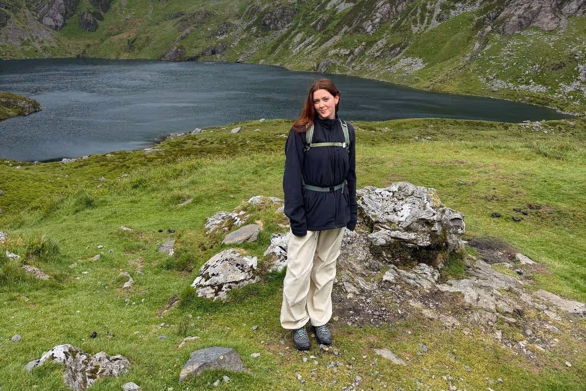
You don’t need to leave the UK to experience unreal views(Image: Emily Malia)
The more I travel around the UK, the more I am in awe of its natural beauty which seems to be overlooked by a lot of keen travellers, and this particular spot feels like a real slice of paradise.
You don’t need to hop on a plane to experience a sense of the tropics; it turns out you can immerse yourself in the brightest hues of green and walk along waterfalls in the north of Wales. While, of course, Snowdonia National Park is no secret, especially to avid hikers, cyclists and explorers, it was my first time visiting, and this specific route is one that blew me away.
It’s often cited as one of the best hikes in Snowdonia (Eryri). Cadair Idris is an 893-metre mountain in the southern part of the park and is renowned for its wild and rugged scenery. To me, it looked like its surroundings could belong in the likes of Peru or Southeast Asia, with its tropical plants, waterfalls and vibrancy of its green grass.
But of course, like any beautiful place in Wales, it reminded me exactly where I was when I spotted sheep dotted around its cliffs, even on the steepest parts. It looked as though the sheep could fall off the edge of the world, taking me with them, as I fought for hours against the growing pain in my shins, with each step up and up to the peak.
The route
I was taken up the Minffordd Path route, which is described as the shortest yet steepest route to the mountain’s summit, tackling a demanding 10 km walk. Overall it’s set to take up to four to five hours to complete, and in turn you are rewarded with dramatic and captivating views of the national park’s landscape.
The route begins at Dôl Idris car park and takes you past the Cadair Idris visitor centre, which quickly fills up. We were recommended to get there early in the morning to beat the pile-up and were thankful that we did; setting off on our walk at around 8am meant we got to experience the quietness of the route in all of its natural wonder. Albeit, the lie-in would have also been appreciated.
Running parallel along the stream which runs parallel to the stream which leads to Llyn Cau, the lake at the heart of the base of the mountain. It was immediately, when taking on these steep steps along the river, that I felt like I could be abroad.
Not only was the sun shining down on us, but the water was trickling down, with tropical plants growing around us, and it felt as wild and wonderful as the experiences I had in Thailand or the pictures I’ve seen of hikes in Vietnam or Peru.
This continued as we made our way out of the forest area and into the open air, with nothing but pure greenery around us, and the mountain stood proudly ahead. The second phase levels lightly as you enter a rocky amphitheatre, with up-close and personal views of the lake.
Pushing past slate and rocks, many of which are loose and therefore can be difficult to navigate, this section and throughout the walk, requires concentration and care with each step. A quick trip or fall could have you stumbling, and that’s why lots of hikers opt to go armed with sticks to help gain their balance and push them through.
By the time I made it to the top of the mountain, the weather dramatically changed, from sunny to high winds which were extremely cold. It’s this that can catch a lot of amateur hikers out, and I think it’s always best to go armed with windproof and waterproof layers, as they say ‘don’t dress for the car park’.
The real treat after that consistently steep hike upwards is this – the flat walk along the edge of the entire mountain before reaching its penultimate peak. Seeing it all from a circular angle gave you a real treat at each point whenever I decided to stop and take a breath.
Wales is the gift that keeps on giving when it comes to my explorations, and Cadair Idris was no exception to that. If you’re willing to take on the circular route and the real challenge of its steep and unsteady ground, then you will be rewarded with a touch of paradise and views you’ll continue to daydream about.
I stood last week in the middle of a highway, marveling as construction workers used large excavators to repair the collapsed roadway.
I was walking a segment of Angeles Crest Highway that closed about five months ago when winter storms pummeled the roadway, ripping off hunks of pavement and collapsing large sections of the road. I wanted to survey the damage and also enjoy a car-free highway in the beautiful backcountry.
In this edition of The Wild, The Times’ weekly outdoors newsletter, I will share what I observed and include details about how you can repeat my trip. I’d say it is a rare opportunity, but it’s starting to feel, especially as human-caused climate change worsens, like Angeles Crest Highway is closed more often than it’s open.
You are reading The Wild newsletter
Sign up to get expert tips on the best of Southern California’s beaches, trails, parks, deserts, forests and mountains in your inbox every Thursday
By continuing, you agree to our Terms of Service, which include arbitration and a class action waiver. You agree that we and our third-party vendors may collect and use your information, including through cookies, pixels and similar technologies, for the purposes set forth in our Privacy Policy such as personalizing your experience and ads.
Angeles Crest Highway, completed in 1956 (in part by prison labor), is a 66-mile curvy road that climbs from around 1,300 feet to nearly 8,000 feet, taking travelers from La Cañada Flintridge to the mountain town of Wrightwood. A large segment, 55 miles, received federal distinction in 1990 as a National Scenic Byway.
For the record:
4:04 p.m. May 21, 2026A previous version of this article said Angeles Crest Highway climbs from 800 feet. The highway begins at an elevation of around 1,300 feet.
In case, like me, you’ve lost the plot of the many recent closures and reopenings of Angeles Crest Highway, here’s a brief refresher.
Winter 2022/spring 2023: Winter and early spring storms, including atmospheric rivers, blow out multiple sections of the roadway, prompting several closures, including: from near Mt. Wilson Red Box Road to Upper Big Tujunga Road; from Upper Big Tujunga Road to Islip Saddle; and from Islip Saddle to Vincent Gap.
October 2023: A 20-mile stretch from Upper Big Tujunga to Islip Saddle reopens; road remains closed from Mt. Wilson Red Box Road to Upper Big Tujunga, requiring drivers to take a detour to reach a newly open section; segment from Islip Saddle to Vincent Gap remains closed.
July 2024: Mt. Wilson Red Box Road to Upper Big Tujunga reopens, ending the need for a detour.
A portion of Angeles Crest Highway where the curved shoulder broke off.
(Jaclyn Cosgrove / Los Angeles Times)
The hiking community celebrated when that final 10-mile stretch from Islip Saddle to Vincent Gulch reopened. The closure blocked access to Dawson Saddle and made the drive to Vincent Gulch to hike the Mt. Baden-Powell trail much longer, as you had to take multiple freeways to maneuver from L.A. around the San Gabriels.
For the first time in three years, all of Angeles Crest Highway was open — for about five months.
Grape soda lupine, left, Grinnell’s beardtongue, snow plant and western wallflower.
(Jaclyn Cosgrove / Los Angeles Times)
Last December, Southern California experienced another round of a damaging atmospheric river. “More than 10 inches of rain fell in parts of the San Gabriel Mountains in Los Angeles County during a 48-hour period,” The Times reported.
Soon, photos emerged of washed-out segments of Angeles Crest Highway, and the California Department of Transportation announced that, yet again, the highway was closed, this time from 3.3 miles east of Newcomb’s Ranch to State Route 138.
Curious to see the damage for myself, I headed up the highway last week to walk a segment of the closure. My plan was to park at the large lot at the 6,000-foot snow play area and then walk along Angeles Crest Highway for about 4½ miles to Buckhorn Campground, a forested enclave where I’ve spent many nights staring up at the stars.
After having lunch at Buckhorn, I planned to backtrack to Cloudburst Summit where I would take the Pacific Crest Trail back to where I parked. The total trip is just shy of nine miles and gains about 1,200 feet in elevation.
The closed gate near the 6,000-foot snow play area in Angeles National Forest.
(Jaclyn Cosgrove / Los Angeles Times)
I walked from the lot past the closed gate, appreciating several grape soda lupine, one of my favorite native wildflowers, blooming along the hillside.
I was alone on the empty highway, a scene that was stunningly gorgeous and eerily dystopian. For the first three-fourths of a mile, the road appeared to be in good condition. But then, I trudged around a bend and observed the first segment of collapsed roadway on my trip.
For anyone considering cycling this route, I am happy to report that CalTrans and its contractors have done a nice job creating dirt and rock berms around the damaged portions of road that I observed. I mention that in case, like me, you watched the 1991 TV series “Land of the Lost” and developed an illogical fear of dropping through a crack in the road and unknowingly discovering a time portal to the Jurassic period.
I continued past this first damaged section, listening to the dark-eyed junco and mountain chickadee, laughing as the chipmunks scampered to and fro.
An excavator works to repair a segment of Angeles Crest Highway.
(Jaclyn Cosgrove / Los Angeles Times)
Soon, at 1.2 miles, I encountered construction workers driving excavators to move earth and repair a drainage area where it appeared water had rushed down the steep mountains and blasted the road away. As you hike or bike, please respect instructions from construction workers and also make sure they see you before you try to pass them.
Just a fifth of a mile farther, and I saw more portions of the roadway that had collapsed, although these sections were smaller than the area the heavy machine operators were trying to repair.
As you hike along, you’ll likely realize that the pavement warms up quickly. It’s important to either start this journey early in the day or on a cooler day — and pack plenty of water.
At about 1.75 miles in, you will reach a junction where the Pacific Crest Trail, a 2,650-mile route that spans from Mexico to Canada, intersects with the roadway. You can turn and head back to your car here if you’d like by taking the PCT. You’ll initially walk west before the trail starts moving southward.
I continued eastward on the highway, pausing at times to appreciate the vista points that you can only observe for a few seconds in a car. At one turnout, I paused to smell the delicious bark of a Jeffrey pine, which has an aroma similar to butterscotch or vanilla.
A view of the San Gabriel Mountains and desert beyond.
(Jaclyn Cosgrove / Los Angeles Times)
For about a mile-and-a-half, there’s minimal damage, enough of a break to briefly forget why the road is closed. But as you near the Buckhorn Campground entrance, you’ll find serious damage, including where the Mt. Waterman ski lifts used to take travelers up the mountain.
I turned off the highway onto the Buckhorn Campground road, finding it to be in fairly good condition — until you get to the creek crossing. A massive chunk of the road is just gone, washed away presumably by water charging down the steep hillsides. This is the only technically tricky part of the hike, and you’ll want to take good care to discern the best path here. There are a lot of branches and boulders that aren’t stable and could be napping spots for rattlesnakes.
Past here, you’ll find rocks and other debris scattered along the roadway. As I neared the campground, I noticed a Stellar’s jay observing me. Maybe it misses the days when all it had to do for food was wait for clumsy campers to drop bits of sandwiches and trail mix that it could swoop down and enjoy.
A washed-out segment of the road that leads to Buckhorn Campground in Angeles National Forest.
(Jaclyn Cosgrove / Los Angeles Times)
I sat atop a picnic table at Buckhorn, comforted that the campsites and tall old pines that I’ve camped under multiple times were still there. Although much of the campground remains intact, some campsites near the creek were washed away. I’ve always wanted to camp there. This is why you shouldn’t put off adventure!
After enjoying lunch and chatting with a few PCT hikers, including one who was lost and grateful for my map, I headed back down the highway. Just over a mile in, you’ll turn left near Cloudburst Summit onto the PCT. Your feet will thank you from this break from pavement.
As I trudged along, the quiet monotony of the day allowed me to make oh-so-brilliant observations to myself, like, “Wildflowers are like spring’s Christmas lights,” a note I left for my future self to remember. I bet you’re glad I wrote that down.
Grape soda lupine blooms along the Pacific Crest Trail in Angeles National Forest.
(Jaclyn Cosgrove / Los Angeles Times)
I was pleased to see so many wildflowers still in bloom along the trail, including several grape soda lupine plants, the alienlike snow plants and a bit of Grinnell’s beardtongue.
Returning to my car, I thought about how much I enjoyed the walk but also how special Highway 2 is, regardless of how you traverse it.
There is no timeline of when the road will reopen. The analysis from CalTrans of what it will take to repair Highway 2 is grim.
“To date, Caltrans crews have identified approximately 40 locations requiring repair, though this number may increase as assessments continue. In several areas, portions of the highway were washed out and remain temporarily inaccessible,” according to the CalTrans website.
A damaged segment of Angeles Crest Highway near the Buckhorn Campground entrance.
(Jaclyn Cosgrove / Los Angeles Times)
It’s becoming increasingly difficult to remain optimistic that we won’t see a growing number of closures along Angeles Crest Highway.
Highway 2 seems to face similar challenges to its coastal cousin, California’s Highway 1, which is increasingly plagued by storms exacerbated by human-caused climate change.
My colleague Grace Toohey spoke to an expert about Highway 1, who made a point that’s unfortunately equally applicable to the plight of Highway 2.
“If our storm and other conditions were normal, we would expect closures and losses at some points,” said Michael Beck, director of UC Santa Cruz’s Center for Coastal Climate Resilience. “The challenge is that we’re now clear that the events that are going to cause impacts — these particularly extreme events — are getting more common. … Climate change is here and now, it’s no longer a problem of the future.”
3 things to do
Hikers head up Icehouse Canyon Trail.
(Brian van der Brug / Los Angeles Times)
Editor’s note: Because of recent wildfires, events might be canceled on short notice. Check event pages before heading out.
1. Eliminate trail obstacles near Mt. Baldy The San Gabriel Mountains Trailbuilders need volunteers on Sunday to help clear fallen trees and remove overgrown brush along the Chapman Trail in Icehouse Canyon near the Mt. Baldy community. Volunteers will meet at 7:30 a.m. at the Glendora Park and Ride before heading to the worksite. Volunteers will hike between four miles and seven miles with an elevation gain of up to 2,000 feet. Register at meetup.com.
2. Mosey past movie scenes near Calabasas Retired park ranger Mike Malone will guide a three-mile moderate hike from 10 a.m. to 12:30 p.m. Sunday through Malibu Creek State Park, highlighting locations where the park served as a backdrop for film and TV productions. Malone will also share history about when the park was owned by 20th Century Fox from 1946 to 1974. Hikers should meet at 10 a.m. at the park’s main trailhead by the restrooms. Learn more at parks.ca.gov.
3. Hike along historical routes in Chatsworth A docent at Santa Susana Pass State Historic Park will host a 3½-mile hike from 8 to 11 a.m. Monday through the Santa Susana Mountains. Hikers will learn about the park’s ancient quarry, Indigenous culture and the Butterfield Overland Stagecoach route. Hikers will meet at the Andora trailhead in Chatsworth. Learn more and register at meetup.com.
The must-read
A trash interceptor made by the Dutch nonprofit the Ocean Cleanup grabs trash from Ballona Creek that could otherwise end up in the Pacific Ocean. Since its installation in 2022, the interceptor has collected more than 200 tons of trash.
(Christina House / Los Angeles Times)
It can be peaceful to take a stroll along the San Gabriel or Los Angeles rivers amid the cottonwood trees, willows and herons. But it’d be impossible not to notice the garbage too. For years, our local rivers have suffered at the hands of humans and the heaps of waste we produce. That could change. “By the 2028 Olympics, a coalition of city, county, state and private partners hopes to change that by deploying trash-intercepting devices in the Los Angeles and San Gabriel rivers, officials announced [last] Wednesday,” Times staff writer Lila Seidman wrote. “The plan is to prevent hundreds of tons of garbage from getting to the ocean.” Could our rivers be clean that soon?
Happy adventuring,
P.S.
Will Southern California’s roving wolf ever find a mate? I can’t be the only one stressing about this. BEY03F, affectionately called “bae” or “Valentine” by some, has been making headlines since early this year when she became the first wolf to enter L.A. County in more than 100 years. She has since traversed hundreds of miles and through multiple counties, with her latest travels bringing her to Sequoia National Park. This again marks the first time in a century that a wolf was documented there. BEY03F keeps making history because humans wiped out her canine kin. Will she ever find a connection that helps her repair some of the harm done?
For more insider tips on Southern California’s beaches, trails and parks, check out past editions of The Wild. And to view this newsletter in your browser, click here.