What is the Rhodes weather forecast and where is the flooding? Latest updates after urgent Greek holiday hotspot warning
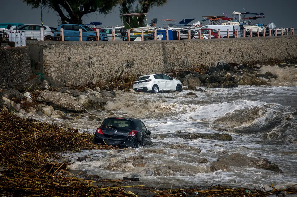
A STATE of emergency has been declared on the Greek island of Rhodes after flash floods swept cars into the sea and claimed the life of a hotel worker.
A Mediterranean autumn storm system has moved across the region, bringing torrential downpours and high winds.


Greek authorities have ordered British holidaymakers to restrict all but essential travel – here’s everything you need to know.
Where is the flooding in Rhodes?
Rhodes’ eastern coastline bore the brunt of the weather, with the area around Stegna beach near Archangelos suffering flash flooding.
A 62-year-old hotel worker was caught in a torrent of water while retrieving his car near the beach.
Coastguard officers later recovered his body after four vehicles were swept into the sea.


Dozens of cars were submerged or abandoned across the island’s road network as drainage systems struggled to contain the rainwater.
Data from the National Observatory of Athens confirmed that Rhodes recorded 264mm of rain, 202mm of which fell in just six-and-a-half hours.
That’s a month’s worth of typical rainfall in a single morning.
What is the current Rhodes weather forecast?
Conditions across Rhodes have begun to calm as the worst of the storm front moves east.
The UK Met Office and the Hellenic National Meteorological Service both forecast drier conditions for the region on Thursday October 15, with sunny spells for the remainder of the day.
Temperatures are expected to peak at 23C, with moderate northwesterly winds between 12 and 16mph.
Though the forecast points toward calmer conditions, forecasters and officials stress that the danger has not fully cleared.
Because the island’s terrain is saturated, more rain could present a risk of further localised flooding and mudslides.
Tomorrow (October 16) is expected to stay largely dry and sunny, but an unsettled Atlantic front is forecast to push across the Aegean Sea over the weekend.
This is expected to bring a renewed chance of showers by Saturday.
Elsewhere in Greece, the Hellenic National Meteorological Service has issued yellow “Be Aware” alerts for Crete and the South Aegean.
What is the advice for holidaymakers?
Thousands of UK tourists visit the region every year for late-season sunshine.
With 112 emergency alerts remaining active, tourists are advised to limit their movements to absolutely necessary journeys.
Several key bridges and roads across Ialysos, Faliraki, Afandou, and Rhodes Town are submerged or damaged by mud.
Authorities have suspended multiple transport routes, including the key Rhodes–Faliraki tourist corridor and services to and from Akandia port.
Greek emergency services recommend that all travellers monitor local weather warnings through the Hellenic National Meteorological Service and follow instructions via the official @112Greece Twitter/X channel.
Never attempt to drive or walk through standing or flowing water, as road surfaces may have collapsed underneath.
Keep an eye on the UK Foreign, Commonwealth & Development Office (FCDO) travel advice pages for Greece regarding sudden disruptions.