Bryson DeChambeau thought he had finished Day 2 of the British Open in second place and just one stroke off the lead.
He apparently thinks that should still be the case — but it’s not.
After a lenghty, and at times animated, discussion involving DeChambeau, his caddie and officials, the U.S. golfer was assessed a two-stroke penalty that dropped him into a fifth-place tie and three strokes back.
Grant Moir, executive director of governance for The R&A, told reporters that DeChambeau was penalized “for inadvertently improving the area of his … intended backswing on the fifth hole when he was playing his second shot.”
Moir added that the penalty “applies even when the action is accidental, as it was in Bryson’s case.”
DeChambeau sent his tee shot 257 yards but far off to the right into tall fescue grass. He needed to step high to get to the ball but was able to hit it out of the area, eventually making bogey on the par-four hole. That score was later changed to triple-bogey, and DeChambeau officially finished the day at two-under 68.
“The player mustn’t move, bend or break any growing or attached natural object,” Moir said. “A player is allowed to fairly take their stance by taking reasonable actions to get to the ball and take a stance if in some situations that improves the condition affecting the stroke, but when doing so the player must take the least intrusive course of action to deal with the particular situation and is not entitled to normal stance or swing.”
At one point during his discussion with Moir, DeChambeau appeared to state that he might not play the next day. He did not speak with reporters afterward, other than to say he thought he played great and that he was going to hit balls on the driving range.
His agent, Brett Falkoff, said DeChambeau was told he was “not careful enough walking around a sensitive area,” adding that his client “certainly feels he was unfairly penalized.”
Asked if DeChambeau would play Saturday, Falkoff said, “Your guess is as good as mine.”
DeChambeau reportedly stayed out on the driving range until after dark, at times whistling, humming and singing while hitting balls and offering reporters snacks.
Lucas Herbert leads after the second round at eight-under, two strokes ahead of Jackson Suber, Cameron Young and Ryan Gerard.
The voluntary pause until Sept. 9 comes after the California Atty. Gen. Rob Bonta and Santa Clara County officials sued the Trump administration last month to block the facility from being developed near Gilroy. The lawsuit remains ongoing.
“This pause in the construction, demolition, and development at the site of the challenged ICE facility is a significant step towards protecting our people, our communities, and our environment while the case remains ongoing,” Bonta said in a statement Monday night.
The Department of Homeland Security, which oversees ICE, didn’t immediately reply to a request for comment.
State and local officials believe the facility will be used for short-term detention of up to 150 people at a time, though ICE denied that it would be a detention center.
Community members and advocates for immigrants swiftly opposed the project. ICE has consistently looked to increase its detention capacity in California, where eight detention centers can now hold a combined 9,000 people, though the state has long been a thorn in the agency’s side.
The halt is part of a compromise between both sides involved in the legal action. After the state and county submitted a request for the court to temporarily halt the project, a hearing was set for Oct. 7.
Now, state and federal officials jointly requested that the court move up the hearing by at least a month. The agreement also extends how much time the federal government has to respond.
A federal judge signed off on the agreement Monday night.
The lawsuit, filed in U.S. District Court in San José, alleges that the leased land is zoned exclusively for agricultural use and that the federal government violated laws requiring state and county notification, as well as procedural steps before beginning construction.
World Cup tourists are coming to L.A. for the soccer, but they’re staying for the $21 smoothies and Double-Doubles.
As the last Los Angeles FIFA World Cup event ended Friday, soccer fans were eating like locals and famous chains from the region were cashing in.
In the weeks that L.A. has hosted the World Cup, international soccer enthusiasts have flocked to big brands from the area, often in large groups wearing their countries’ jerseys.
It is a phenomenon seen at many of the host cities. In Dallas, giant gas station Buc-ee’s is the main attraction. For people visiting New Jersey, deli shops have been a hot ticket. In L.A., the place to be between matches was Erewhon.
Thirsty international sports fans gathered for pictures outside different Erewhons, wandered their aisles smiling, and, of course, picked up pricey smoothies.
While Erewhon would not comment on its business, mobility data company Arity, which uses phone data to track consumers, said Erewhon visits at the outlets around SoFi Stadium were quadruple what they were a week earlier on June 12, the day of the U.S. national soccer team’s opening match there.
Arity looked at what stores people visited within a 10-mile radius of SoFi that day and also found surges in visitors to nearby El Pollo Loco and Trader Joe’s.
Locals have spotted groups of people in Korea jerseys huddled together, trying to decide what to order at In-N-Out.
Some complained on social media that international tourists at Trader Joe’s were buying up all the mini canvas tote bags.
Soon after the Belgium vs. Spain quarterfinal ended Friday, the In-N-Out near SoFi had a long line of soccer fans stretching out the door in bright red and yellow and black jerseys and matching striped hats and scarves.
One of the workers said he had to explain “spread” and “animal style” to foreign football fans.
“I didn’t know this place existed,” a fan from Romania said while waiting in line.
Los Angeles and other cities and states that have hosted the event need the soccer fans to spend money to make the event worth all the time, effort and money it requires.
A rosy 2024 report projected the World Cup could bring more than $800 million to the L.A. region as 180,000 people converge on the area to sleep, eat and spend.
There were early concerns people weren’t turning up for the event because of the high ticket prices and the difficulty of obtaining visas for citizens of some countries.
However, at least for some L.A. hotels, there was a surge of last-minute visitors which pushed up occupancy and room rates.
While sports fans are not in the region to shop, they do make time for it.
World Cup customer spending is also apparent in beer sales. Andrew Heritage, the chief economist at the Beer Institute said beer purchases at entertainment and attractions in L.A. – outside of World Cup spaces – were up around 10% from normal.
“That tells me that fans in the L.A. area have decided to extend their stay and take in all the other things that the area has to offer, rather than just the match itself,” he said.
On social media, the purpose of these shoppers is clear: grab a quick souvenir or local specialty and take a selfie.
The data from Arity suggests that fans are very efficient when they spend at local spots, diving in, getting what they want and getting out as soon as possible, said Jeff Schlitt, a director at the company.
“Normally you’re there for an hour. They’re going to be there for 15, 18 minutes,” he said. “Why is that? Because they were purpose-driven shoppers.”
For some travelers, the more popular American chains aren’t unfamiliar. But some of the native L.A. fare still comes as a surprise.
As one Belgium-Spain matchgoer from the Netherlands stood taking a picture of the In-N-Out sign after the game, he said he’d never had a burger like the one he’d just tried.
“We only have McDonald’s and Burger King,” he said. “It’s way better.”
PHOENIX — For decades, all that separated the U.S. from Mexico was barbed wire.
Now, after a massive infusion of cash from Congress, President Trump’s administration is swiftly building what it has dubbed a “smart wall,” a combination of 30-foot-tall steel fencing and an array of sophisticated technology like sensors, cameras and towers allowing Border Patrol to surveil the territory.
The wall is under heavy scrutiny for the billions of dollars being dedicated to it when border crossings are at their lowest in decades. Critics say the U.S. is militarizing the border as it increasingly deploys sophisticated surveillance technology to the area, impacting local communities.
“We are seeing a massive expansion of surveillance and surveillance technology across the borderlands,” said Ricky Garza, border policy counsel at the Southern Border Communities Coalition, an advocacy group. “The wall in all its forms is harmful to communities.”
Officials say the technology is complementary to the physical wall and frees up agents for other tasks.
“It’s a smart wall. It’s not just a barrier,” Customs and Border Protection Commissioner Rodney Scott said during recent congressional testimony. “It maximizes the use of our most valuable resource, which is our agents.”
Contracts for hundreds of miles of wall already inked
The wall has been a top priority for Trump, a Republican, since he first ran for president.
During the administration of President Joe Biden, a Democrat, the border emerged as a flashpoint, with thousands of people seeking to cross into the country each day. Those numbers started to taper off shortly before Trump returned to office last year and then slowed to a trickle, with his broader immigration crackdown serving as a deterrent for would-be migrants.
Flush with $46 billion to finish the wall after an infusion by Congress for immigration enforcement, CBP is inking tens of billions of dollars in contracts to build the wall and push along the president’s signature project.
Homeland Security Secretary Markwayne Mullin said recently that a preliminary part of the wall will be finished by “this time next year.” Scott said his agency is putting up 6 miles of wall a week.
Hundreds of miles had already been built before Trump returned to office. As of mid-June 2026, CBP has erected another 74 miles and aims to build hundreds more. There is no wall planned for roughly 535 miles of the roughly 2,000-mile-long border, because rugged terrain already serves as a barrier. Ground sensors and towers will be used instead.
CBP is also going back to hundreds of miles of already built wall and adding more technology, lights and roads. Along the long stretches of river in Texas that mark the border with Mexico, they’re deploying 12- to 15-foot-long cylinder-shaped buoys meant to keep migrants or smugglers from crossing the border.
More technology being deployed on the border
Technology is playing a greater role in the Trump administration’s effort to make illegal crossings along the border more difficult, part of a broader transformation of CBP in the years since Sept. 11, 2001, into an intelligence operation with a mass surveillance network whose reach extends far beyond the nation’s frontiers, according to reporting by The Associated Press.
And critics say the border technology poses a threat.
The Southern Border Communities Coalition says surveillance technologies can push migrants into more dangerous routes to avoid being detected.
Garza, the group’s policy counsel, warned that surveillance technology infringes on the privacy rights of border residents and that locals have found ground sensors used to detect smuggler or migrant traffic placed on their property without their consent.
Nayda Alvarez and her relatives own land along the Rio Grande roughly 125 miles inland from the Gulf of Mexico. She has found cameras placed on her family’s land, and just last week she spotted a surveillance tower about a quarter of a mile down the river from her house.
“Are we expecting a war or something?” she said. “It doesn’t make me feel safer.”
Dave Maass, director of investigations for the Electronic Frontier Foundation, a nonprofit that focuses on civil liberties related to digital technology, said the technology has made the border area “a hostile environment” for locals and would-be migrants.
The foundation has published a guide on the various types of surveillance towers in use along the southern border designed to help local residents.
These can range from fixed towers with video, infrared and radar technologies that have a range of roughly 8 miles to remote video surveillance systems that have cameras and a spotlight fixed on top. Some are mounted on the backs of trucks so agents can drive them to different parts of the border.
Increasingly, these towers are autonomous. They can scan an area, analyze what they’re seeing using artificial intelligence and alert Border Patrol agents to something suspicious. Proponents say this helps keep Border Patrol agents out in the field instead of sitting in front of computer screens watching for activity. But it also increases AI decision-making along the border when experts have warned about the technology’s potential for bias or other problems.
The big GOP tax cuts and spending bill passed by Congress last summer requires that CBP buys only the autonomous towers, and the department is deploying an additional 95.
Underground, buried fiberoptic cables can sense movement, capturing data that is also then analyzed by AI.
“We follow the contour of the land. We go through trees. We go down into the river banks. We can go absolutely everywhere,” said Magnus McEwen-King, CEO of Sintela, which has a contract with CBP to install the cables. He spoke at a recent border security expo in Phoenix, where some of the technology was on display.
CBP also uses ground sensors and trail cameras to detect smuggling routes.
Concerns over cost and future plans
The nonpartisan watchdog group Taxpayers for Common Sense has questioned both the huge amounts of money for the wall-building and whether taxpayers are getting their money’s worth.
In 2011, under Democratic President Obama, Homeland Security Secretary Janet Napolitano pulled the plug on a project to build a “virtual wall” of integrated technology like radars, sensors and cameras across the entire border after it ran over budget, faced technological glitches and was behind schedule.
Josh Sewell, director of research and policy at Taxpayers for Common Sense, said the organization would like to see more “robust evaluation” of the technologies being used to avoid similar scenarios. And he criticized the Trump administration for lack of oversight on how the money is being spent, a charge CBP has denied, citing “oversight mechanism.”
In the Big Bend area of southern Texas, opposition to the department’s wall-building plans gathered strong bipartisan support especially in the most sensitive areas that run through a state and national park and a wildlife area.
CBP now says it is not planning to build a 30-foot-high bollard wall in those areas. Its recently announced plans include installing patrol roads and some barriers designed to stop cars and using detection technologies.
Clara Benson, who is one of the founders of the No Big Bend Wall coalition, says bright lights in the area designed to illuminate the border could pollute the skies in an area renowned for having some of the best views of the stars. Even without a 30-foot-tall steel wall running through the land, there is concern about CBP’s plans.
“There’s still a lot of fear and dread that the plan is still going to be quite damaging,” she said.
California Forever, the tech billionaire-backed group that hopes to build a city from scratch on farmland in the outer San Francisco Bay Area, is lobbying state leaders to fast-track a massive shipbuilding deal that would kick-start its development after years of local opposition.
The billionaires behind the project are seeking a deal to expedite environmental reviews of the development and, if necessary, bypass county restrictions on building by being absorbed into Suisun City boundaries. They’ve hired former Senate President Pro Tem Darrell Steinberg and former Senate Majority Leader Bob Hertzberg — Democratic architects of landmark environmental laws — to make their case, and are using the prospect of luring a major shipbuilder to California to accelerate the dealmaking.
California Forever has pursued its project for nearly a decade, though the vision has shifted: At first pitched as a walkable city with cottages, bike lanes and even a water park, the plan then added a major shipbuilding operation and, last summer, a significant manufacturing hub. California Forever’s proponents, led by the state’s powerful building trades union along with Realtors, peace officers and pro-housing groups, argue the latest proposal would boost the state’s economy and bring an estimated half a million jobs to California. And now, a prospective tenant has emerged: Defense company Saronic Technologies Inc., which builds autonomous vessels for use in national security, is deciding between California and Texas for its next factory. The state must fast-track the development or lose the deal, supporters argue.
The developers are seeking the state’s permission to use an 18-year-old environmental impact report for the shipyard development, limit any legal challenges to the project to 270 days, and allow Suisun City to annex their land if needed, according to Steinberg and Hertzberg.
“In short, if legislation is not approved, California will lose billions of dollars in investments and tens of thousands of jobs this summer to Texas and other states,” proponents wrote in a joint letter to Gov. Gavin Newsom and legislative leaders this week.
But some locals and lawmakers are skeptical, arguing that details about the project remain scarce. The proposed development would convert vast farmlands into factories and risk harming the surrounding ecosystem, they said, which deserves rigorous environmental review under the landmark California Environmental Quality Act that proponents are seeking to expedite.
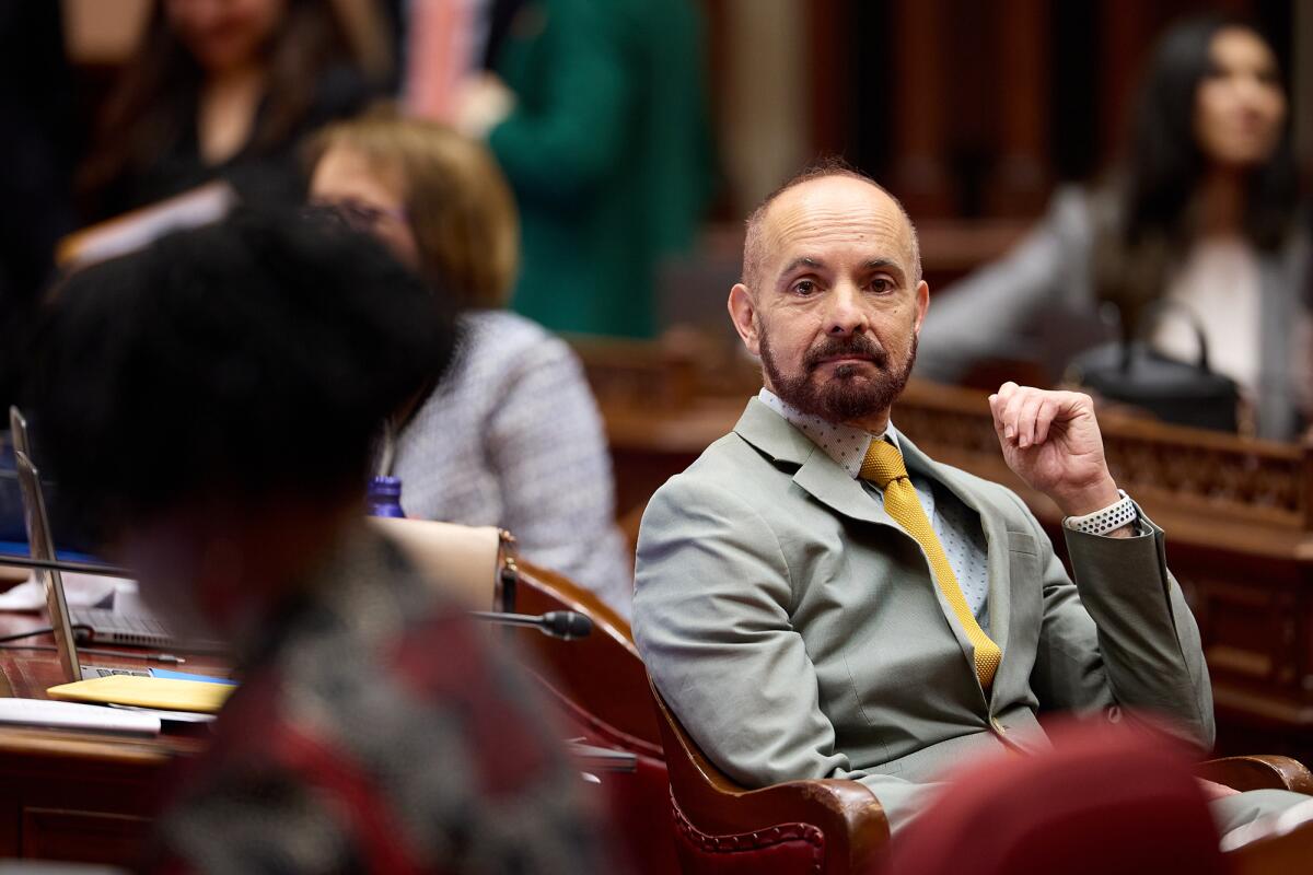
State Sen. Christopher Cabaldon (D-West Sacramento) is shown during a Senate floor session at the state Capitol in Sacramento on Feb. 20, 2025.
(Fred Greaves / CalMatters)
“For a project this scale in this location, it is what the [law] was designed for,” said Sen. Christopher Cabaldon (D-West Sacramento), who represents the area. “A central question for the people of Solano County is: Is this going to be for the community or is this a conversion project that leaves them behind?”
Opponents also slammed California Forever for pursuing relief behind closed doors with state leaders and circumventing local opposition. Since 2018, the group has secretly bought up agricultural land, shelled out hundreds of millions of dollars to court local residents and spent at least $330,000 lobbying the governor and legislative leaders for favorable legislation.
“I think they know that the only way this actually happens is under cover of darkness, by trying to essentially get the governor to work this plan for them,” said Jordan Grimes, legislative director at Greenbelt Alliance, which has advocated for streamlined environmental reviews for housing projects.
Secretive beginnings foment distrust
For residents of Solano County, an agricultural community on the outskirts of the Bay Area that includes coastal areas next to a deep-water shipping lane, the suspicion around California Forever has been hard to shake.
The group’s subsidiary, Flannery Associates, started buying up farmland in 2018, eventually acquiring 62,000 acres while routinely refusing to answer questions about its backers. Some farmers later alleged the company used strong-arm tactics to get them to sell.
In 2023, Flannery’s backers were unmasked as a group of wealthy venture capitalists, including the founders of LinkedIn and Netscape, all led by former Goldman Sachs trader and real estate developer Jan Sramek. Marc Andreessen, co-founder of venture capital firm Andreessen Horowitz, holds investments in both California Forever and Saronic, the defense company eyeing California. Andreessen’s firm did not immediately return a CalMatters inquiry for comment.
Despite rocky beginnings, California Forever needed the majority of Solano County voters on its side due to a 1984 “orderly growth” law that requires voters to approve development on unincorporated land.
In 2024, the company debuted the East Solano Plan to rezone 17,500 acres of agricultural land for a dense, 400,000-person city. The proposal was set to go before voters that year, but its backers pulled it following powerful grassroots opposition, poor polling and a county assessment that found holes in the plan. Sramek acknowledged the group likely moved too fast and said the initiative would go back before voters in 2026.
Instead, the group has pivoted. The East Solano Plan has become the Suisun Expansion Plan and the Solano Shipyard. In January 2025, Suisun City’s city council directed its manager to explore expanding the city’s limits through annexation, which is now underway, although it could take years.
State Route 113 runs through land where California Forever plans to put its new city in Solano County.
(Loren Elliott / CalMatters)
“The annexation and the shipbuilding have been a clear way to work around the need for voter support in Solano County,” said Nate Huntington, a member of the grassroots group Solano Together, which formed in response to the secretive land purchases. Huntington pointed out that California Forever hasn’t even submitted a proposal for a shipbuilding facility to the county.
“All of this has been happening in backrooms of Sacramento, and it’s not been publicly available.”
Seeking state environmental relief
California Forever is now selling the development to the state as a major incentive to lure manufacturers and shipbuilders to California — and the subsequent need for housing to accommodate the promised jobs.
The company wants the governor and state lawmakers to cut red tape for the development and require enough housing for the new jobs. Steinberg and Hertzberg told CalMatters they are contemplating legislation to that end, but only after California Forever signs a lease with a manufacturer or shipbuilder.
Their plan would allow the governor to designate construction on company land as “environmental leadership development projects,” which would effectively require any litigation to be resolved within 270 days. Steinberg authored the state law streamlining that process in 2013.
State law requires government agencies to prepare a report for any project that might have a significant impact on the environment. Instead of assessing the impact of the proposed shipyard, Steinberg and Hertzberg’s proposal would use a 2008 report, which designated the area where the shipyard would go as “water-dependent industrial usage.” Most of California Forever’s 7,500-acre planned footprint does not have that designation.
Steinberg told CalMatters the report is sufficient since the site has changed little.
“The state and county need the ability to say yes now to these numerous opportunities,” he said in a text. A new report, he said, “would require years of additional delay and lost opportunities.”
But the report is outdated, Cabaldon argues.
“This is completely different,” he said. “Just the notion that you would just say, ‘We are not going to do any assessments at all and we’ll just rely on this old one’ — that is not consistent with what the public interest is.”
Steinberg and Hertzberg also want the state to require enough housing in the area, but to allow surrounding cities and Solano County to permit local housing developers to build first.
But if local governments aren’t willing to or cannot build enough housing within the timeline the manufacturer or the shipbuilder wants, Steinberg and Hertzberg’s proposal would allow Suisun City to annex adjacent California Forever-owned county land into its city boundaries — a controversial idea that has drawn fierce local opposition. The move would be a “last resort,” Steinberg and Hertzberg stressed repeatedly.
The annexation would effectively bypass the county’s orderly growth initiative, which requires voters to have a say in development.
“The shipbuilders and manufacturers need certainty on a much faster timeline,” Steinberg said.
Cabaldon said the pitch to build new housing to accommodate theoretical jobs is “fantastical,” noting that Saronic, the proposed shipbuilder, is a leader in automation.
“There’s no indication that this is going to generate on an ongoing basis that many jobs, and certainly not more jobs than we have housing for even today without building a single additional unit,” he said.
Historic union agreement prompts support
In January, California Forever announced it had signed a 40-year deal with the Napa/Solano Building Trades Council and Northern California Carpenters Union to use union labor to build its development. The agreement was an important political alliance for Chief Executive Sramek, bringing more influential advocates to the table.
According to Digital Democracy, both the Building Trades Council and the Carpenters Union have given roughly $10 million in direct donations to legislative candidates since 2000.
Those advocates made themselves heard over the last few weeks, following a Texas county court approving significant tax incentives to lure Saronic to Brownsville. In a statement, Saronic said its nationwide search is still “active and ongoing.”
The California Alliance for Jobs, an alliance of influential construction companies and workers, drafted two letters in quick succession calling for legislative leaders to streamline the California Forever expansion and shipyard.
“We champed at the bit to go all in to get this project moving, and to get legislation through Sacramento this session,” said Joshua Arce, executive director of the alliance.
Suisun City Councilmember Princess Washington, who has consistently been the sole vote on the council against the annexation plan, said she feels organized labor is being used as “political pressure” to win approval.
“Processes are slow, but they’re done that way through government to ensure that it’s being done correctly, that all parties of interest are being treated fairly, and there’s checks and balances,” Washington said.
“It’s unheard of for a project to be done as quickly as they want it to be done.”
In a statement, California Forever spokesperson Jim Wunderman said any shipyard project will comply with all California environmental and land-use laws. He said county supervisors already approved using the 2008 impact report, and that legislation would allow the group to “meet prospective employers’ timelines.”
He said by pursuing expansion within Suisun City, California Forever is following the community’s preferences by channeling new growth into existing cities.
An ongoing presence in the Capitol
Since 2024, California Forever has spent at least $330,000 lobbying the Legislature and governor’s office on bills and other actions, according to campaign finance records.
Steinberg and Hertzberg told CalMatters they were hired in April as “special counsel,” not lobbyists, meaning they are spending less than a third of their time talking with public officials.
Grimes, who said he respects Steinberg for leading landmark environmental land-use reforms in the Legislature, said he’s disappointed in his advocacy for California Forever, “a project that is antithetical to all of this.”
Sheep graze on land where California Forever plans to build its new city in Solano County.
(Loren Elliott / CalMatters)
California Forever reported spending $90,000 lobbying the governor’s office and the Governor’s Office of Business and Economic Development, called GO-Biz, last year on “federal shipbuilding activities and California business attraction and retention activities.”
“GO-Biz has discussed relevant state incentive programs with Saronic and explained how they operate,” said GO-Biz spokesperson Willie Rudman. He said the agency does not offer incentive packages to specific companies.
Last fall though, GO-Biz helped organize a bid for Saronic to settle in Solano County. County staff reported during a board meeting that GO-Biz supported a legislative effort to override the county’s “orderly growth” law.
County supervisors rushed through a proposal to change the boundaries of the Solano Shipyard to comply, but with just days remaining before the end of the legislative session, Assemblymember Lori D. Wilson, a Democrat from Suisun City, said there wasn’t time to introduce legislation.
Since then, Wilson said, the proposal has been on the table, but “nothing’s been requested” of her office by California Forever.
The company also urged lawmakers to act fast or risk losing the shipbuilder to Texas last year — a negotiating tactic common in economic development, Cabaldon said.
But Cabaldon argued that Saronic will decide where to place its shipyard based on “defense needs of the United States of America” instead of state incentives.
“We have to negotiate with our eyes open,” he said.
I’ve been intrigued by the Northern California area of Humboldt County ever since the fourth grade. That’s when my teacher told us the story of the Gold Rush town of Eureka: In the 1850s, when prospectors struck gold, they would yell “Eureka!” which is Greek for “I have found it!” What a funny word, I thought.
My curiosity about the area later grew when I learned about its logging renaissance — vast swaths of old-growth redwood forests were felled to make ships and build railroads, both of which were needed to transport this valuable commodity to the rest of the country and beyond. It wasn’t until 1918 with the formation of the Save the Redwoods League that preservation efforts began to try to halt the rapid depletion of the old-growth forests, which, by that point, had dwindled down to between 5% to 10%. From those efforts, Humboldt Redwoods State Park was established in 1921, followed by the formation of Redwoods National Park in 1968. Today the four parks that make up Redwood National and State Parks cover about 139,000 acres of land and protect nearly half of the world’s remaining old-growth redwood forests.
And it was the lure of walking beneath these giants that I, decades past that fourth-grade history lesson, finally decided to make my pilgrimage.
It took this long because, dear reader, Redwood National and State Parks are not easy to get to from L.A.
By car, without accounting for traffic and breaks, it would be at least a 12-hour journey along the 101, through San Francisco, past wine country and bypassing Mendocino before you reach Humboldt County, where the southern end of the parks begin. Realistically, it would take a few days and a couple of overnight stays along the way to get there, which is fine if you’re in it for the road trip; but if you’re like me and only have the weekend, this leaves one option: flying into California Redwood Coast-Humboldt County Airport, a.k.a. Arcata-Eureka Airport (ACV), the only airport that services the area. United has direct flights there from LAX. But Burbank Airport has Breeze Airways offering direct flights three times a week with prices as low as $80 roundtrip.
When I landed at Arcata-Eureka Airport, it felt smaller than some municipal airfields — and just as quiet. That calm set the tone for the rest of the weekend. I walked in peaceful serenity between trees so tall and ancient they recalibrated my sense of time. I discovered that life in Humboldt County, and neighboring Del Norte County near the Oregon border, moves at that same unhurried pace. The fog retreats slowly in the morning. Night arrives gently, carried in on the mist.
And I learned that Humboldt County — including the cities of Eureka, Arcata and Ferdale — is full of treasures beyond its abundance of the Earth’s tallest trees. Whether I was eating a greasy cheeseburger at a family-run diner that becomes the social center of town after 9 p.m. or slurping oysters at a bar that harvested them from its own farm just offshore, it became clear that this place is shaped by discovery, exploitation and preservation. What follows are hikes, sights and bites that should get you started for a weekend full of your own “Eureka!” moments.
About This Guide
Our journalists independently visited every spot recommended in this guide. We do not accept free meals or experiences. What should we check out next? Send ideas to guides@latimes.com.
The 2026 National Pub and Bar Awards has celebrated some of Britain’s best boozers, and winners range from city gastropubs, pubs that embrace their arty heritage, and cosy country pubs found on islands
Pubs are still an important part of many communities(Image: Getty Images)
The UK’s best drinking establishments have been named at the 2026 National Pub & Bar Awards and a wide variety of pubs across the country took home accolades.
Our interactive map shows the winners that took home Pub & Bar of the Year for their region, as well as the overall winner of the prestigious National Pub and Bar of the Year, which went to the Gunton Arms near Cromer in Norfolk.
The Gunton Arms describes itself as “a traditional pub with bedrooms, set within an extensive historic 18th-century estate”, and it offers 16-bedrooms, a luxury four-bedroom thatched cottage, plus a restaurant with a focus on local ingredients. So local, in fact, that the venison cooked over the fire grill is sourced from the deer park that surrounds the pub.
The pub also has an impressive selection of art on the walls from contemporary artists such as Damien Hirst and Tracey Emin, which complements the rustic, cosy décor.
Regional winners included The George in Fitzrovia, which took home the regional award for London. This 18th-century, grade II listed pub has a warm, welcoming feel thanks to the jewel-coloured interiors and gold accents, and in addition to serving “great Guinness”, it has a menu centred around Irish cuisine with international touches.
The Ferry Inn, found on the fishing village of Uig on the Isle of Skye, won the North Scotland Pub & Bar of the Year. This 19th-century island inn has three boutique rooms you can stay in, an impressive selection of gins from Scotland and around the world, plus a curated whisky shelf for a wee dram.
Other winners included Caledonian Heritable, who took the award for Pub Group of the Year, while Bar Group of the Year went to Albert’s Schloss, a chain of German-themed pubs offering live entertainment, Bavarian dining and a wide selection of European beers.
The Tyrrells Tyrrellbly Good Taste Award went to The Welldiggers Arms in Petworth, West Sussex, which describes itself as a “traditional country pub” and has views across the South Down National Park.
The pub has a focus on fresh, locally sourced British cuisine, and it offers a daily menu of pub classics, as well as brunches and traditional Sunday roasts.
The 2026 National Pub & Bar Awards winners by region
East Midlands Pub & Bar of the Year: The Tollemache Arms
East of England Pub & Bar of the Year: The Gunton Arms
London Pub & Bar of the Year: The George, Fitzrovia
North East Pub & Bar of the Year: The Kirkstyle Inn and Sportsman’s Rest
North West Pub & Bar of the Year: Church Inn, Mobberley
Northern Ireland Pub & Bar of the Year: Guildhall Taphouse
North Scotland Pub & Bar of the Year: The Ferry Inn, Isle of Skye
South Scotland Pub & Bar of the Year: The Noble, Glasgow
South East Pub & Bar of the Year: The Mason’s Arms, Clanfield
South West Pub & Bar of the Year: The Bath Arms, Warminster
Wales Pub & Bar of the Year: George III, Dolgellau
West Midlands Pub & Bar of the Year: The Bull’s Head, Craswall
Yorkshire and the Humber Pub & Bar of the Year: The Woolly Sheep Inn, Skipton
National Pub & Bar of the Year: The Gunton Arms
Have a story you want to share? Email us at webtravel@reachplc.com
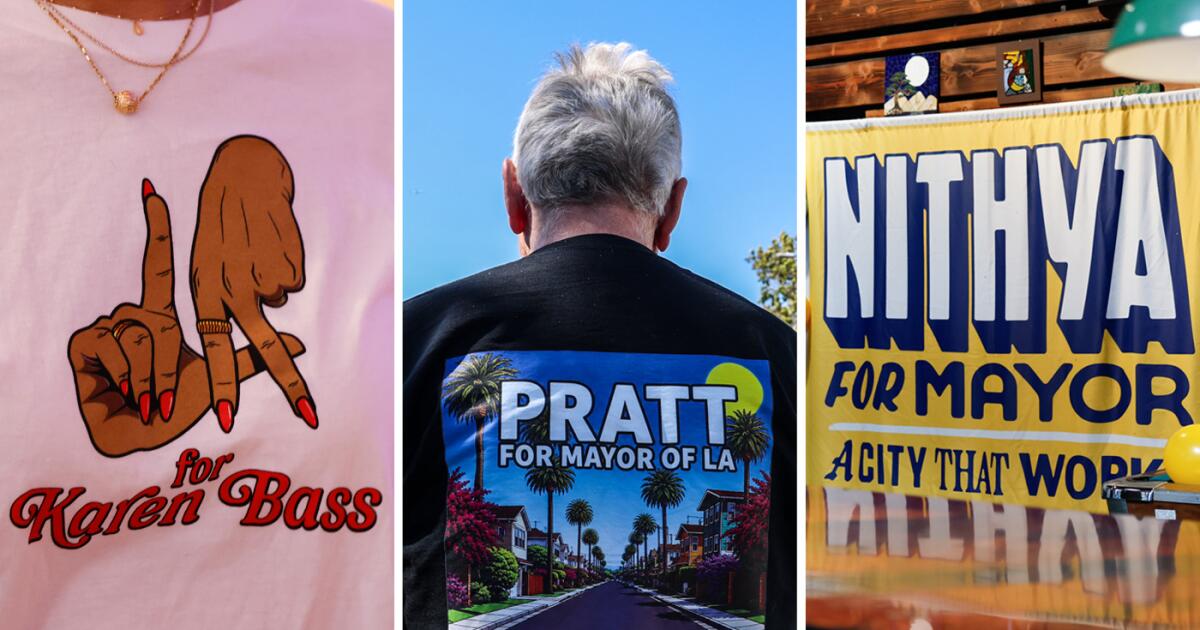
Mayor Karen Bass ran the table in South Los Angeles, Spencer Pratt found strong support from his Westside base, and Nithya Raman racked up votes in Echo Park and other neighborhoods with a concentration of renters, according to a Times analysis of partial precinct-level results from this week’s primary election.
The Times analysis, based on an estimated 62% of the ballots counted so far, found that Pratt was favored in many of the same neighborhoods that voted for mayoral candidate Rick Caruso in 2022, while Raman made inroads in progressive areas dominated by Bass four years ago.
Bass found support in neighborhoods along much of the Harbor and Santa Monica freeway corridors, along with central San Fernando Valley communities from Van Nuys to Arleta.
With much of the vote left to be counted, a map prepared by The Times showing how neighborhoods voted represents a snapshot of an election still very much underway. Bass garnered enough votes on election night to qualify for a Nov. 3 runoff, the Associated Press determined, but votes are still being tallied and it’s not yet clear if she will face Pratt or Raman.
Early returns show Pratt with a significant lead over Raman, but some analysts expect the remaining ballots to lean Democratic, as many left-of-center voters held onto their mail-in ballots until the last minute as they waited to choose between Democratic gubernatorial candidates.
Not surprisingly, Pratt did well in the Pacific Palisades, where his home burned down in the 2025 fire, garnering 60% in one precinct. The next closest candidate there was Adam Miller at 14%.
A registered Republican, Pratt also led in many of the more conservative neighborhoods that were dominated in the 2022 mayoral primary by Caruso, a former Republican who switched to being a Democrat before running for mayor. Pratt was ahead in much of the Westside and the West Valley, the analysis found, including much of Woodland Hills, Encino, West Hills and Chatsworth — just like Caruso four years ago.
“The Pratt vote mirrors a tremendous amount of the Rick Caruso vote: geographically, demographically and ideologically,” said Dave Jacobson, a Democratic consultant and co-founder of J&Z Strategies.
Certain Valley neighborhoods that supported Caruso didn’t go to Pratt, though, as Bass made inroads in areas including Northridge and North Hills, extending her support farther west into the Valley than she did in her last primary.
At the same time, Pratt appeared poised to win some neighborhoods that Bass carried in 2022. He was leading in Studio City and Hancock Park, according to the preliminary returns in areas where Bass led Caruso after the primary.
Bass’ stronghold in South L.A.
Bass’ support eroded to some extent since 2022, when she secured 43% of the vote in the primary against Caruso, then-Councilmember Kevin de Leon and leftist Gina Viola, the analysis based on partial returns shows. Even so, Bass outperformed her 2022 primary results in many areas south of the Santa Monica Freeway, though the precincts are slightly different than they were four years ago, making direct comparisons difficult.
In one precinct in Gramercy Park, Bass picked up 82% of the vote so far — up from a similar precinct where she won about 75% of the vote in 2022. Part of Bass’ dominance in the area could have to do with the fact that Pratt and Raman didn’t perform as well as Caruso did in many of these South L.A. neighborhoods.
Still, in some parts of the neighborhood, Bass underperformed 2022, though she still won more than half the vote.
In a Baldwin Hills neighborhood precinct where she won 77% of the vote last time, Bass was down to about 64% this year so far, as Raman took 20% of the precinct and Pratt had 9%. In 2022, Caruso won less than 13% of the area.
Bill Carrick, a longtime Democratic consultant, said it was unsurprising to see Bass’ support continue to be strong in South L.A.
“She’s been in the community there, lived there a long time and represented them in various capacities,” he said. “She’s a pretty well-known figure. She’s tied into all the networks.”
The Raman factor
The partial election returns show Raman leading the pack in precincts known for their progressive politics, particularly those with younger people in renter-heavy neighborhoods stretching from Hollywood to Highland Park.
Every neighborhood that Raman won was taken by Bass during the primary in 2022, though Viola, a leftist candidate that year, also did well in these precincts compared with other parts of the city.
On the Westside, Raman found few spots to lead, taking Sawtelle and Palms by fairly narrow margins, although those margins could possibly increase as more votes are counted.
She also dominated the Westwood precinct that includes UCLA, winning 56% of the vote in one precinct, compared with Bass’ 19% and Pratt’s 10%. And in a Los Feliz precinct in her council district, Raman so far has 58% of the vote, far ahead of Bass and Pratt.
Still, as of Wednesday, Raman was trailing in 54 of the 66 precincts in her own council district.
Zachary Donnini, a data expert with the nonpartisan group VoteHub, said he expects to see Raman’s numbers rise as the county continues to count late-arriving mail-in ballots, which he says tend to skew younger and more Democratic — which is Raman’s base.
“All the areas that are good for Pratt are going to become less good for him, and all areas that look less good for Raman are going to look better for her,” Donnini said.
Too close to call
Across the city, certain battleground precincts were so tight that no single candidate had a lead as of Wednesday’s count, on which The Times’ analysis was based.
In two adjacent Koreatown precincts, Bass and Raman were tied, with 117 votes in one and 187 votes in another, with Pratt trailing not far behind in both.
Bass and Raman also split a downtown Los Angeles precinct with 199 votes each, though Raman carried much of the rest of downtown, which Bass won in 2022.
In the Valley, it was Bass and Pratt who split precincts. In one Sun Valley precinct, the two each took 151 votes compared with Raman’s 80. They also tied in an Encino precinct.
Weekly insights and analysis on the latest developments in military technology, strategy, and foreign policy.
Yesterday, TWZ published an analysis of a thermal image purportedly showing a previously unseen advanced aircraft design, which appears to be a precursor to the U.S. Air Force’s forthcoming F-47 fighter from Boeing. The image, which went viral online and is from a video that has now been released, is said to have been captured near the U.S. military’s secretive Groom Lake test base, better known as Area 51. It turns out, as a number of our readers have pointed out, there may be some interesting similarities between this secret aircraft and a “Christmas tree” fighter design concept crafted decades ago by Darold Cummings, one of the top minds behind Northrop’s YF-23 Black Widow.
You can find our full initial assessment of what we may be seeing in the viral image, first posted online by the Project Fear YouTube channel earlier this week, here. What we saw initially, as shown below, appeared to feature what could be described as a “double arrowhead” profile to its forward fuselage. This is a very distinct design cue, but it could also be a result of the low quality of the image and the artifacts that come with consumer-grade thermal imagers, which was what the aircraft was recorded with.
A close-up look at what is visible in the viral thermal image. Capture via Project Fear
Project Fear has now released the full video it says it captured near Area 51, seen below, and it underscores the aforementioned points about image quality. So, it is possible the aircraft has a more traditional low-observable ‘shovel nose,’ instead. Nonetheless, the Christmas tree fighter is an interesting trip down lesser-known fighter development memory lane that is worth examining, in particular what such a unique nose configuration would provide an advanced fighter aircraft.
The full clip of the mysterious aircraft passing by starts at around 49:34 in the runtime of the video below if it does not automatically start playing at that point.
We Filmed a Top Secret Craft Flying at Area 51
People are asking why it would be running a very bright light. Multiple reasons, could have had an emergency for all we know. But most likely, would be to keep its silhouette from being seen from certain aspects from the ground. Bright lights are established practice for… https://t.co/mxEvG2EUkz
“I was hired by Bob Sandusky in 1982 to be the Chief Configurator for the Northrop ATF [Advanced Tactical Fighter] program (YF-23). In early 1983 Bob said that Northrop had tried to develop a ‘4-spike’ (like the B-2) fighter, but it couldn’t be done, since a flying wing fighter was not possible,” Cummings wrote in his post on LinkedIn. “I told him I could design one, and he said to give it a try. The only way to accomplish this was with a series of highly swept (55 degree) surfaces over the entire length of the aircraft. The result was the DP-21, created in June of 1983.”
“4-spike” here essentially refers to the total number of radar cross-section hot-spots and where they are located, each pointing in a different direction in azimuth. The fewer ‘spikes’ a low-observable (stealthy) aircraft has, the easier it is to manage its radar signature, and to make it harder to detect and lock onto, but it’s also where those spikes are located that matter.
The blueprint of the DP-21 “Christmas Tree” fighter concept. Darold Cummings
A four-spike design like the B-2 critically has nothing from the head-on aspect, as well as from the rear, which helps immensely with survivability. These are the most critical signature areas, especially the front as the aircraft is heading into hostile territory. Also, because these are located along the path of flight, these spikes can stay consistent on a threat radar as the aircraft moves directly toward or away from the sensor, and are not fleeting in nature like those from the side. So a four spike aircraft would be very attractive for a tactical fighter meant to persist in contested territory.
“I never considered this to be a serious contender for the ATF program, as the aircraft was unstable beyond 10 degrees angle of attack!” he also noted.
“Back in 1983, the ‘Christmas Tree’ DP-21 would have been difficult to fly. However, with modern flight control systems, this design could be controlled, even at high angle of attack,” Cummings told TWZ directly today after we reached out for more information. “Low observability is always better served with long edges on the design, so the small arrow-shaped foreplane is not ideal, but it still has low RCS characteristics, just not the optimum.”
“Wing shaping is always a trade-off for maximizing LO. Most of the trades have to do with the leading edge contour, which is a large contributor to signature,” he continued. “The canard has to be designed to be ‘ported’ during penetration, as this minimizes the signature. On the YF-23, the V-Tail was ‘ported’ in penetration for the same reason. This is certainly possible with modern flight control systems.”
“Ported” in this instance refers to keeping the control surface locked in the same geometric plane as the wing while cruising.
A top-down look at the YF-23 during a flight test. USAF
We also asked Cummings directly whether it was possible his DP-21 concept had an influence on what is seen in the viral thermal image, assuming it is authentic. And we asked for his take on what impacts Boeing’s experimental X-36 and Bird of Prey designs may have had on the F-47, as well.
“My DP-21 aircraft image has been available publicly for quite some time, so it is possible it had some influence, but that is only speculation on my part,” he told us. “I believe the X-36 and Bird of Prey have both influenced the F-47 design. I have always been impressed by the X-36, as it seemed to be ahead of its time.”
Boeing’s X-36 demonstrator. NASA/Carla Thomas Boeing’s Bird of Prey. USAF
“The Groom Lake images are truly intriguing,” he also noted. “It is a viable concept.”
“I think the main thing to remember is that NO ONE thought a 4-spike design (like the B-2) was possible, and my DP-21 was an example of how it was possible,” he added. “A 4-spike design for the F-47 would truly be impressive!”
“The image shows an exotic design by any interpretation. The aft-set lambda-type wings appear to have a camber and wingtip droop, as on the Boeing Bird of Prey demonstrator. There are very large canard foreplanes — a feature that appears prominently on F-47 renderings and which we have written in detail about in the past. The broad nose, too, is something that has been included in depictions of the F-47, although we have really no idea to what degree these are based in reality. It’s worth noting that in this new thermal image, it has a distinctive double-arrowhead shape, tapering in again in front of the canards. Even the canards themselves may have more than one plane, with the outer tips being drooped, matching similar architecture as the wing. The fuselage then tapers down in the center before the wing roots begin.”
“The aircraft is very likely to be tailless, a feature common to most sixth-generation concepts seen so far. However, since it’s seen from below, we cannot be sure about this aspect of its configuration.”
“As for the powerplant, it is most likely a twin-engine design, like the F-47, a theory reinforced by the sawtooth-type trailing edge. There is no obvious suggestion of any exhaust plumes, which seems odd, but that could be the result of the sensor being used in combination with the aircraft’s power setting at the time of recording, as well as general thermal signature reduction capabilities that are part of the design.”
Beyond the nose end, there are still some very broad similarities in the shaping of the wing and main body of the aircraft seen in the footage and Cummings’ DP-21 concept.
As we noted yesterday, what is seen in the viral thermal image could be unrelated entirely to the F-47. The Navy has also been pursuing a carrier-based sixth-generation fighter, commonly referred to as F/A-XX, in recent years. There has been at least some crossover between F/A-XX and the Air Force’s NGAD effort. A rendering Boeing has shared of its proposed F/A-XX design looks very much in line with what has been shown of F-47 to date. Northrop Grumman is the other company currently competing to build the Navy’s sixth-generation carrier fighter, and has released its own renderings.
Boeing’s F/A-XX render. Boeing
In addition, it should be said that official F-47 and F/A-XX renderings released to date will have been carefully manipulated to maximize security of the programs, both of which remain highly classified, and to provide disinformation to adversaries.
As an aside, Darold Cummings also shared his take on a prospective navalized version of the F-47 in a separate post on LinkedIn last year. At that time he wrote:
“I received a DM asking if I had envisioned a Navy version of my recent F-47 fighter concept, such as the F-35A to F-35C approach. I recently completed my F-47 Navy version, which I call the F-47N. However, the approach I took was somewhat different: The F-35C used a larger wing for low speed lift, whereas I used my original F-47 wing planform, and added a canard for more low speed lift and control. The canard design (inspired by the X-36), coupled with the Multi-Axis Thrust Vectoring (inspired by the X-44), provided a very reasonable first cut at a Navy version. In general, a canard layout has been treated as adding more radar signature to a fighter. However, on the YF-23 we found that if the all-moving surface (it was a V-tail on the YF-23) was kept “ported”, in this case aligned with the wing plane during cruise, the impact on LO was not a large impediment to signature reduction. The ability to keep the canard ported is achievable using thrust vectoring for trim in cruise and penetration modes.”
Cummings’ interpretation of the F-47 design at that time notably did not reflect his previous DP-21 concept. The X-44 design he mentioned is also known as the Multi-Axis No-Tail Aircraft (MANTA), and was derived from F-22. At least to our knowledge, the MANTA never came to be. The designation was recycled for an entirely unrelated flying wing-type drone, the existence of which was first reported by TWZ.
Darold Cummings’ drawing of his notional “F-47N.” Darold CummingsRenderings of the X-44A MANTA. Lockheed Martin/NASA
It’s also worth noting that the design in the newly emerged thermal video could be tied to one of many other programs, including uncrewed ones. Still, it is very much in line with what we would expect to see from a design related to the F-47 and it seems very likely this is the Boeing NGAD demonstrator, if the video is indeed authentic, which it appears to be.
It would be nice to say that we will have to wait and see whether this aircraft turns out to have a more traditional shovel-shaped nose, or even a mild Christmas tree-like design, but we may never see it again. Hopefully that is not the case, especially after the F-47 goes public, but the final design will have significant differences from its technology demonstrator forebears.
Special thanks to @ElectroFluidSys on X for bringing Darold Cummings’ posts on LinkedIn to our attention.
Demonstrators march during a rally in Tirana on Wednesday calling for a proposed $1.6 billion luxury resort in an enironmentally sensitve island location off Albania’s Adriatic Sea coast by an international consortium led by Donald Tump’s son-in-law, Jared Kushner. Kushner and wife Ivanka Trump stumbled upon the uninhabited island during a vacation. Photo by Malton Dibra/EPA
June 4 (UPI) — Thousands of Albanians marched in the capital Tirana for a third day straight to protest against a $1.6 billion luxury resort backed by Donald Trump‘s son-in-law, Jared Kushner, in a national marine park off the country’s Adriatic Sea coast.
Some demonstrators in Wednesday’s protest held inflatable flamingos aloft to highlight the impact they fear the project will have in and around Sazan Island, where work recently got underway in the midst of one of the Mediterranean’s most environmentally-vulnerable areas.
Scuffles broke out with police who fired water canon at protesters.
An offer to meet with opponents from Prime Minister Edi Rama, who has staked his premiership on what he has billed as a developmental coup for the former communist state, was rejected as calls for the project to be halted grew, with protests also set to spread to the south of the country.
“From start to finish there has been a total lack of transparency. We have seen no public consultation or public documentation regarding permits, and so now what we are saying is, if they remove the bulldozers, remove the fence and restore the habitats to what they were, then we can start talking,” said Aleksandr Trajce, executive director of Protection and Preservation of the Natural Environment in Albania.
“We were on a friend’s boat, and we stopped for a swim. Effectively, that’s how we found it. We swam to the island. We went on a hike, barefoot all the way up to the top, and we were just captivated,” Ivanka Trump said.
Environmentalists are worried about the effect the resort will have on an area that includes the currently uninhabited Sazan Island and the nearby wetlands and coastal habitats of the Karaburun-Sazan Marine Park.
BirdLife International said the park’s waters around Sazan and the Karaburun peninsulta were among the last places where Mediterranean monk seals survive and support populations of flamingos and Dalmatian pelicans as well as 200 other species of birds, many of which are endangered.
Sazan Real Estate Development, which is developing the plans in partnership with Kushner’s Miami-based investment firm, Affinity Partners, insisted it was committed to sustainable development.
“Our focus remains on responsible stewardship, environmental enhancement, job creation, and creating long-term value for local communities. We respect the ongoing public and institutional processes,” said Sazan Real Estate Development chair Asher Abehsera.
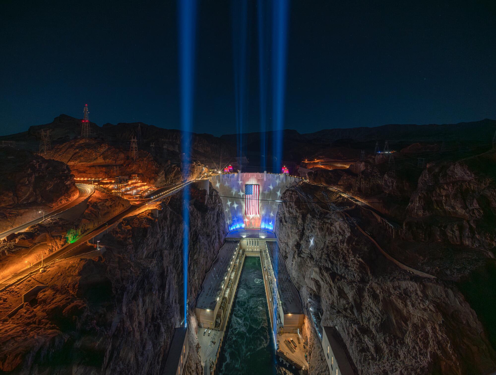
Nope, it’s not AI. It’s just a really big flag with bright lights, draped on Hoover Dam for the next several weeks.
As a display to mark the 250th anniversary of U.S. independence, the states of Nevada and Arizona and the federal Bureau of Reclamation teamed up to hang and illuminate an enormous American flag on the dam on Memorial Day.
The display, scheduled to be in place through July 4, is visible to anyone crossing between Arizona and Nevada on U.S. Route 93, which goes across the top of the dam. The flag is 150 feet tall and 300 feet long, spread on the south-facing side of the dam and lit by 550 LED lights (powered by dam-generated electricity).
A wider view of the illuminated U.S. flag at Hoover Dam.
(Michael Bittle)
It’s a spectacle that comes at a challenging moment for Hoover Dam, as experts warn that Lake Mead’s dwindling water levels could threaten the dam’s ability to generate hydropower. “Slap a flag on it, that’ll fix it,” suggested one of several Reddit commenters who were moved to snarkiness by the flag image.
The dam, a frequent day-trip destination from Las Vegas, stands 35 miles east of the Las Vegas Strip, about 295 miles northeast of Los Angeles. The site features a visitor center and overlook, and guided and self-guided tours.
Installation of the display involved dozens of riggers and two cranes. The flag, which is roughly the dimensions of a football field, has been previously used for celebrations at Indianapolis Colts and Las Vegas Raiders football games.
Within two days after it was hung, gusts of wind up to 50 mph prompted organizers to lower the flag last Wednesday as the National Weather Service declared a wind advisory for the area. Organizers raised the flag again late Friday.
Strong winds are not uncommon in the area. Organizers said weather “may periodically require the flag to be temporarily lowered.” Updates on the flag’s status can be found on the Hoover Dam Facebook page.
The Las Vegas Convention and Visitors Authority paid for the display. A spokeswoman said the cost, including flag, production, installation costs and six weeks of lighting, will be between $750,000 and $1 million.
The dam, a five-year construction job that was completed in 1936 during the depths of the Great Depression, is often hailed as one of the nation’s most impressive works of infrastructure. Though this is not the first time a flag has been draped on it, organizers have called the display “the most ambitious long-duration installation ever attempted at Hoover Dam.”
Route 66 has its tendrils throughout SoCal, and especially in the L.A. area, winding through Pasadena, West Hollywood and culminating in Santa Monica. But the most loving ode to Route 66 may in fact be at the Disneyland Resort, specifically at Disney California Adventure.
Stories, photos and travel recommendations from America’s Mother Road
Cars Land opened in 2012 as part of a reworking of the theme park and at long last gave it a striking land that could rival — and in many cases surpass — those of its next-door neighbor, Disneyland. Flanked by sun-scarred, reddish rocks that look lifted from Arizona, Cars Land is a marvel of a theme park land, with its backdrop mountain range ever so slightly nodding to the fins of classic Cadillacs from 1957 to 1962. That design element is a salute to the Cadillac Ranch in Amarillo, Texas, where 10 vintage Cadillacs are buried nose-first in the ground that to many resembles a 20th century Stonehenge.
Yet before the area was attached to the 2006 film, it was envisioned as a theme park destination dedicated to roadside attractions and trips along the so-called Mother Road. Cars Land is a make-believe area based on a fictional town from an animated film, but its roots are decidedly real.
Cadillac Ranch, an artwork made from 10 old cars by the Ant Farm artists’ collective in the 1970s, has become one of Amarillo’s top attractions. Visitors are invited to add their own spray-painted touches.
(Christopher Reynolds / Los Angeles Times)
The backdrop mountain range of Radiator Springs Racers is a nod to Cadillac Ranch. The peaks are designed to look like the tail fins of classic cars.
(Mark Boster / Los Angeles Times)
“We very much acknowledge that up front, that you’re walking down Route 66,” says Kathy Mangum, the retired Walt Disney Imagineer who served as the executive producer of Cars Land.
“But you’re also not walking down a part of Route 66 that exists anywhere,” Mangum continues. “There’s no part of Route 66 where you’re looking up at a Cadillac range surrounded by red rocks. It’s the spirit of Route 66. I wouldn’t even call it a ‘best-of.’ It’s just a little bit of this, a little bit of that, and combined it feels real.”
Tour guide Michael Wallis, left, and Walt Disney Imagineer Kevin Rafferty during a research trip at Cadillac Ranch in 2008.
(Kevin Rafferty)
Before those at Walt Disney Imagineering, the secretive arm of the company devoted to theme park experiences, were even aware that Pixar Animation Studios was working on the “Cars” film, an automotive-focused land was in the planning stages for Disney California Adventure. The park had opened in 2001 and had struggled in its early years to pull in crowds, with audiences zeroing in on a lack of Disneyland-style attractions and an absence of grandly designed vistas.
In an effort to rejuvenate the park, then-Imagineer Kevin Rafferty envisioned an area to be called Car Land — without the “s” — pulling heavily from his family’s road trips and Route 66-like roadside attractions and oddities. Among its standout attractions was to be one initially named Scoot 66, later changed to Road Trip, USA, a slow-moving ride that took guests on a cross-country journey through nature and roadside quirkiness, although its showcase scene would have been a trip trough a miniaturized Carlsbad Caverns, a bit of a detour from Route 66.
“It was kind of tongue-in-cheek,” says Rafferty, now retired, of the never-built ride. “You were going to be seeing all these roadside attractions that would draw you in, like giant bunnies.”
Mater’s Junkyard Jamboree brings the rusty, old tow truck character from the “Cars” movie to life in Cars Land at Disney California Adventure. (Mark Boster / Los Angeles Times)
An artwork in Seligman, Ariz., pays homage to the Disney-Pixar “Cars” movie, which was heavily inspired by the town. (Mark Lipczynski / For The Times)
Rafferty believed a place such as Car Land would be ripe for exploration in a Disney park, as it was to be set from the late 1950s to the early 1960s and tap into a collective nostalgia for a time when a vehicle meant the freedom to explore the open road. Cars Land today still has some of that ageless energy, boasting a vintage rock ’n’ roll soundtrack and a strip of a street filled with colorful neon, its lights, especially at night, beckoning guests to come closer.
“The reason why I thought it would fit into a Disney park, especially Disney California Adventure, is because cars are so much a part of the California story,” Rafferty says. “Cars are designed in California, even though they’re built elsewhere. There’s more custom shops in California. There’s more design studios in California. There’s more car clubs. And all the cars songs. ‘She’s so fine, my 409.’ It was all the Beach Boys and Jan and Dean.”
The neon signs of Radiator Springs. Flo’s V8 Cafe isn’t a direct match for any Route 66 diner, but it was inspired in spirit by the Midpoint Cafe in Adrian, Texas.
(Paul Hiffmeyer / Disneyland Resort)
Development on Rafferty’s Car Land idea would change course when Imagineering and Pixar eventually aligned. But it was also a shift that would more formally ground the area in the culture of Route 66, which heavily influenced the film. Both the filmmakers and, later, those with Imagineering, embarked on 10-day research trips along the road led by historian Michael Wallis, author of “Route 66: The Mother Road.” Those at Pixar, in fact, were so charmed by Wallis’ tours that the author was asked to voice the role of the film’s sheriff.
Wallis says he took the teams out in rented Cadillacs. “I like to stop every 300 yards,” Wallis says. “If I’m doing a road trip, I get into it. So we stopped to move box turtles off the road. I waded them into winter wheat to dance, to pick wild grapes. I introduced them to people that I guaran-damn-tee that they never would have met, the great characters of the road, and I showed them the man-made and natural sites of the road.”
Though the fictional “Cars” and Cars Land community of Radiator Springs has no single inspiration, it echoes the scenery and history of several small towns between Tulsa, Okla., and Kingman, Ariz., including Tucumcari, N.M., Seligman, Ariz., and Oatman, Ariz. And the single, graceful bridge that is centered upon the land’s backdrop mountain range closely resembles Pasadena’s own Colorado Street Bridge, although there’s no roaring waterfall next to the original.
Scenes from Route 66 in Seligman, Ariz. The town was one of the inspirations for the fictional “Cars” and Cars Land town of Radiator Springs.
(Mark Lipczynski / For The Times)
The centerpiece bridge of the Cars Land mountain range was modeled after a local landmark. (Paul Hiffmeyer / Disneyland Resort)
The Colorado Street Bridge in Pasadena, an inspiration for the Cars Land structure. (Adam Markovitz)
Elsewhere, Ramone’s House of Body Art connects with the U-Drop Inn, a 1936 Art Deco gas station in Shamrock, Texas, that now serves as a visitor center and cafe. The Cozy Cone Motel nods to the Wigwam motel chain, which once included seven locations from Kentucky to California. Two remain in business along Route 66: the Wigwam in San Bernardino and another in Holbrook, Ariz.
While Imagineers had visual references from the animated film, Mangum says the research trip was invaluable in lending authenticity to the park.
“We could walk into a building in Shamrock, Texas, that looks so much like what Ramone’s House of Body Art looks like and see that those tiles are made of raised terra-cotta,” Mangum says. “So we could get the actual texture. It’s a movie world, but it’s also a real world.”
Flo’s V8 Cafe isn’t a direct match with any Route 66 eatery, the Imagineers say, but was certainly influenced in spirit by the Midpoint Cafe in Adrian, Texas.
The Midpoint Cafe in Adrian, Texas, celebrates the halfway point on Route 66 between Chicago and Los Angeles.
(Christopher Reynolds / Los Angeles Times)
“We sampled all their pies and food and made copious notes on this stuff,” Rafferty says. “The two women who owned the Midpoint Cafe had what they said was their mother’s recipe for ‘ugly crust pies.’ We fell in love with ugly crust pies. I met with the head chef of Disneyland, who was a Frenchman at the time, and I said we wanted to serve ugly crust pies at Flo’s V8 Cafe. And he said, ‘No, no, no, nothing at Disneyland will be ugly.’”
No, but it may be influenced by abandoned buildings. Mangum says a key locale for the land was the deserted structures of Two Guns, Ariz. Gas station remains led to sketches that would inspire parts of the “Stanley’s Oasis” area of the Radiator Springs Racers queue, which Rafferty and company filled out with an oil service station and then a building composed of empty oil bottles. The story goes that Stanley’s Oasis is a roadside attraction settlement that led to the development of the town of Radiator Springs.
At the Cozy Cone Motel, a string of cone-shaped food stalls sell quick bites such as swirled soft-serve cones. (Stephanie Breijo / Los Angeles Times)
The Cozy Cone is based on the real-life Wigwam Motels. (Christopher Reynolds / Los Angeles Times)
“That kind of Route 66-inspired story was all made up,” Rafferty says. “It wasn’t in the film.” That backstory, however, would inform the 2012 short “Time Travel Mater.”
The enduring strength of the land, however, isn’t just due to the popularity of the animated properties that led to it. While Route 66 wasn’t magic for everyone — the history of the road is dotted with tales of extreme poverty and horrific racism — it’s become romanticized as a slice of Americana and stands as a jumping-off point to further delve into our past.
The land is, in a word, timeless. It’s also representative of the ideal of a working small town, the sort of place we forever long for. “It may not be the America of today,” Mangum says, “but in a way it is.”
Times staff writer Christopher Reynolds contributed to this report.
TWO retired RAF rescue helicopters have been transformed into luxury glamping pods.
The old aircraft have been given a new life after decades spent carrying out dramatic search-and-rescue missions across Britain.
Sign up for the Travel newsletter
Thank you!
Two RAF helicopters have been turned into glamping podsCredit: SWNSThe cockpit was cleverly transformed into a dining areaCredit: SWNS
The bright yellow Sea King helicopters are now parked at North Yorkshire Water Park, at Wykeham Lakes, near Scarborough.
ZE369 and XZ589 have had their specialist rescue interiors ripped out and replaced with cosy living spaces complete with a double bed, bunk beds and a mini kitchen with a microwave, kettle, toaster and fridge.
However, the aircraft hasn’t lost all of its original charm with some parts still preserved.
Parts of the cockpit, including the switches and controls, have been kept intact and reworked into a dining area.
Inside features bunk beds, a double bed and a small kitchenCredit: SWNSKitchen is equipped with a kettle, toaster, microwave, and fridgeCredit: SWNS
Guests enter through the original sliding helicopter door, which opens onto a gravel landing pad complete with a picnic bench.
The water park says the unusual stays are designed to offer couples and families a “unique” and “memorable” experience.
The pods only became available to book from May 1 with prices starting from around £130 a night.
The demand has already gone through the roof with the first four weeks sold out on Airbnb.
Guests will have plenty to do nearby too as the 250-acre waterpark offers inflatable aqua parks, kayaking, paddleboarding and open-water swimming.
James Whitehead, Operations Manager at North Yorkshire Water Park, said: “Both helicopters have an extraordinary history, having spent decades carrying out life-saving search and rescue missions across the UK.
“It was important to us that the original character and charm is preserved as much as possible while making them a cosy place to relax after a day of fun.”
The sands of Oceano Dunes — the only state park where visitors are usually allowed to drive on the beach — are unusually quiet right now.
Too quiet, many locals say, because off-road vehicles and beach camping have been temporarily banished from San Luis Obispo County’s Oceano Dunes State Vehicular Recreation Area since April 14.
Many others, however, are happy about the pause, saying it will be good for the western snowy plover, a threatened sea bird species.
This discord is part of a long-running battle between environmentalists and recreation advocates along this stretch of coastline a few miles south of Pismo Beach. The environmentalists won the most recent round when a federal judge ordered the dunes closed until state parks officials obtain a permit from U.S. Fish and Wildlife Service that allows occasional bird casualties.
State parks officials, who have canceled all camping reservations in the area through May 22, said they hope to reopen it by May 23. But that timetable depends on permit approval by the U.S. Fish and Wildlife Service, which did not immediately respond to a request for comment.
Camping reservations for May 23 and beyond are still active, according to Jon O’Brien, superintendent of the state parks system’s Oceano district.
(Myung J. Chun/Los Angeles Times)
Meanwhile, along Pier Street in Oceano, business is slow.
At Sun Buggy Fun Rentals, which has been catering to visiting families for more than 20 years, “we’ve had to lay a majority of our folks off,” said owner Randy Jordan. He said he’s counting on state parks officials “doing everything they can” to reopen the area on May 23.
At the Pier Street Deli y Mas, “It’s been really slow,” manager Chelsea Nava said. “Our employees are losing hours.”
In normal times, Nava said, 80% or more of her customers are from out of town, including “a lot of people from Bakersfield and Fresno, [who] come in for the dunes.”
“We aren’t quite sure” what to expect next, Nava said, noting that her family took over the deli in late 2024. “We were doing really great right before the closing,” she said.
The closure was ordered by U.S. District Court Judge Anne Hwang, who ruled April 9 that the state needs to do more to protect the western snowy plover, which is classified as threatened under the federal Endangered Species Act.
Under Hwang’s order, the closed area can reopen when the state files a long-awaited habitat conservation plan and gets an “incidental take” permit from U.S. Fish and Wildlife Service that allows some snowy plover deaths and injuries. Jon O’Brien, superintendent of the state parks system’s Oceano district, said he was confident that the state would obtain the approval and reopen the area almost immediately after May 22.
Camping reservations for May 23 and beyond “are still active,” O’Brien said. “So if you’ve got a camping reservation for May 24, you’re still got a reservation.”
Jim Suty, president of the Friends of Oceano Dunes, which favors recreational use of the area, said he’s hopeful that parks officials can open the area as promised. But even if they do, Suty said, plenty of damage has been done.
“People really need to appreciate that closing the park at this time did nothing to help the endangered species, and did everything to hurt the people,” Suty said, referring to visitors and local businesses that depend on them. “It’s very important to the vitality of the local community.”
“It’s maddening,” said David Hamilton, who lives in nearby Arroyo Grande and said he has been driving the dunes and watching sunsets with his wife for years. “There’s so much coastline and they can’t leave this small stretch open.”
The recreation area’s status has long been crucial to Oceano, an unincorporated community of about 7,000, located just to its north.
Though there are several neighboring small cities along the nearby coast, Oceano merchants say they don’t get much business from Grover Beach, Arroyo Grande or Pismo Beach, which includes more upscale hotels and restaurants with clifftop ocean views.
Oceano Dunes State Vehicular Recreation Area remains the only California State Park where vehicles may be driven on the beach.
(Myung J. Chun / Los Angeles Times)
The judge’s order covers roughly 800 acres of off-highway vehicle area south of Arroyo Grande Creek. Until April 14, O’Brien said, up to 350 campers per night (at $10 per vehicle) were allowed in the area, along with up to 1,720 off-highway and 1,800 street-legal vehicles per day, at $5 per vehicle.
The most recent court case was initiated in 2020 by the Tucson-based Center for Biological Diversity. Zeynep Graves, a senior attorney at the center, said in a statement that state officials “have let off-road vehicles tear through protected habitat at Oceano Dunes, injuring and killing snowy plovers, harassing roosting flocks, and degrading their habitat.”
However, state parks statistics show that the western snowy plover breeding population has grown from at least 32 breeding adults in 2002 to at least 281 in 2024, exceeding state targets since 2013.
In her ruling, Hwang found that California state parks had violated the federal Endangered Species Act by permitting too much activity near the birds without having obtained an “incidental take” permit.
State parks officials responded by saying the closure “will result in thousands of families losing their camping reservations and coastal recreational access, while cutting operational revenue that funds environmental conservation.”
During the closure, Pismo State Beach — which is just north of the off-highway recreation area and Arroyo Grande Creek — will allow a maximum of 1,000 street-legal vehicles per day (and no off-highway vehicles). Pismo State Beach’s two campgrounds (near the beach but not on it) remain open.
Oceano Dunes is the state’s only oceanfront off-highway vehicle recreation area. Drivers have been driving on the beach and dunes there since the early 20th century. The state acquired the land in 1974 and created the Oceano Dunes State Vehicular Recreation Area in 1982.
Through the years, state parks officials have gradually reduced acreage open to off-highway vehicles as recreation advocates and environmentalists have debated how much protection the birds need. Often, the battle has pitted the California Coastal Commission (seeking to curtail vehicle access) against leaders of California State Parks (seeking to continue vehicle access).
Apart from closures, Oceano Dunes recently faced another challenge. Because of CoVID-19 safety measures, the area locked its gates in 2020-21. During that time, rare shorebirds started nesting in areas usually reserved for off-roaders and their beach-riding vehicles. In 2021, the California Coastal Commission sought to permanently end off-road driving in the dunes but was later overruled by court rulings that the agency had overstepped its authority.
Throughout the debate, the area has remained popular. In 2022-23, the most recent fiscal year for which statistics are available, the area drew more than 908,000 visitors, including about 126,000 campers.
WASHINGTON — The Secret Service says a suspect who opened fire Monday on the National Mall did so after being confronted by officers.
Secret Service Deputy Director Matt Quinn said officers returned fire. A bystander was struck by the suspect, Quinn said.
Quinn said the motorcade of Vice President JD Vance transited through the area not long before the shooting, but there was no indication it was the target.
The incident happened Monday afternoon around 15th Street and Independence Avenue near the Washington Monument.
The Secret Service encouraged people to avoid the area as emergency crews responded to the shooting not far from the White House, where President Trump was holding a small-business event.
The White House was briefly locked down as authorities investigated the incident. The Secret Service ushered journalists who were outside into the briefing room, and Trump continued his event without interruption.
Vito Maggiolo, spokesman for the D.C. Fire and EMS Department, said emergency units took an adult male to a hospital and were treating what appeared to be a teenage male for minor injuries. He referred other questions to the police department.
The incident drew a large police presence, coming just over a week after a gunman tried to storm the White House Correspondents’ Assn. dinner with guns and knives. Cole Tomas Allen has been charged in that incident, in which a Secret Service officer was wounded.
The Redondo Beach Pier reopened Sunday afternoon, hours after police and city officials ordered its evacuation for reasons law enforcement has declined to disclose.
“Police Activity on the Pier. Anyone in the area of the pier is requested to evacuate safely,” the statement read. “Catalina [Avenue] between Torrance [Boulevard] and Beryl [Street] are closed. Please stay away from the pier area until further notice.”
The department issued an update on X at 11:57 a.m. saying that the pier would remain closed until further notice.
At 2:21 p.m., the department sent out another message through the city’s alert system saying that police activity had concluded and that pier and its surrounding area were once again open to the public.
Redondo Beach City Councilmember Brad Waller weighed in on the evacuation in the comments section of BeachLife’s initial postponement announcement on Facebook.
“There was a threat made to the pier, and the area was evacuated to allow the police and dogs to clear the area,” Waller wrote. “Police are still going over the pier area and have expanded to BeachLife. There was no threat made to BeachLife, but out of an abundance of caution, they want to ensure that the area is safe before thousands of people enter. The pier area and BeachLife space were searched, and nothing was found. BeachLife should be ready to open and proceed.”
The Times has reached out to the Redondo Beach Police Department for more information.
The evacuation came on the last day of the Redondo Beach-set BeachLife Festival, which was scheduled to open at noon and feature performances by My Morning Jacket, Peach Pit, Sheryl Crow and James Taylor.
In a social media announcement, organizers for the festival said the start of Sunday’s event would be delayed at least an hour.
“Safety comes first. In cooperation with our public safety professionals in the City, out of an abundance of caution, we have coordinated to temporarily delay doors until 1 p.m. due to ongoing police activity on the Redondo Pier near Torrance Boulevard,” BeachLife wrote in the statement.
In a subsequent post that went live at 1:43 p.m., the organization said it had been given the all-clear to open its doors to the public.
“Per the direction of local safety officials, we have been given the go ahead to safely open doors momentarily,” the statement said. “We appreciate the patience from our community and look forward to a wonderful of day of sun, fun, and great music.”
Not every crowd will gleefully applaud and cheer a known notorious villain. But the Disneyland faithful certainly will, as when Darth Vader set foot in the park’s Star Wars: Galaxy’s Edge on Wednesday morning and the audience erupted in approving hollers.
Kylo Ren has officially been evicted from the fictional “Star Wars” town of Black Spire Outpost. Vader has instead taken up residence, and he will appear multiple times daily in front of the land’s militaristic TIE fighter before stalking the area on the prowl for Luke Skywalker.
In Vader’s first two appearances Wednesday, he spoke of his quest to hunt down the young Jedi. He was flanked by two classic Stormtroopers, who had different dialogue in each showing — one time critiquing Black Spire Outpost and later talking of a run-in with a Jedi.
Vader isn’t the only new addition to the area. Leia, Han and Luke, the latter of whom previously appeared in the land for a limited time last year, are also now regularly appearing in Galaxy’s Edge.
Their presence marks a major shift in direction for the 14-acre theme park land. When Galaxy’s Edge opened in 2019, it was set at a fixed point in the “Star Wars” timeline, namely one in the middle of the latest films in the series.
This was done in part to promote the new cinematic works, but to also facilitate interaction, placing guests on an unknown adventure rather than one with a fixed outcome. It was a theme park experiment to see how much Disneyland attendees would lean in and role play.
But Disneyland wisely hasn’t completely pivoted on the Galaxy’s Edge mission. The characters appear out in the land and on a quest rather than simply standing and posing for photos.
Leia, for instance, spent the bulk of one appearance working with the furry Chewbacca to fix up the starship Millennium Falcon. Later, she joked around with Luke and asked young fans if they wanted to train to learn the ways of the Force.
Palestinians in central Gaza and the occupied West Bank have begun voting in municipal elections, the first local vote held since the start of Israel’s genocidal war on Gaza.
Polling stations opened at 7am (04:00 GMT) on Saturday for 70,000 eligible voters in Gaza’s Deir el-Balah area – the first electoral exercise in the besieged enclave in 20 years.
Recommended Stories
list of 4 itemsend of list
The vote in a single city in Gaza is largely symbolic, with officials calling it a “pilot”. Deir el-Balah was selected because it is one of the few areas in Gaza not destroyed by Israeli forces.
Nearly 1.5 million registered voters in the occupied West Bank are also voting to determine the makeup of the local councils overseeing water, roads and electricity.
The elections come amid a tightly restricted political landscape and deep public disillusionment, as the Palestinian Authority (PA) seeks to project reform and legitimacy amid growing public frustration over corruption, political stagnation and the absence of national elections since 2006.
A Palestinian woman casts her ballot at a polling station during municipal elections in the village of al-Badhan, north of Nablus, in the occupied West Bank [AFP]
Most electoral lists are backed by President Mahmoud Abbas’s Fatah movement or independent candidates, with no official participation from Hamas, which controls parts of Gaza.
Linking the occupied West Bank and Gaza
With much of Gaza decimated by more than two years of war, the Ramallah-based Central Elections Commission chose to hold its first vote in Deir el-Balah. It had to improvise because it was unable to conduct traditional voter registration.
“The main idea is to link the West Bank and Gaza politically as one system,” its spokesperson, Fareed Taamallah, said.
The commission has not coordinated directly with either Israel or Hamas ahead of the Deir el-Balah vote and has been unable to send materials like ballot papers, ballot boxes or ink into Gaza, he added.
Though Palestinian voter turnout has gradually decreased, it has been relatively high in past local elections by regional standards, according to commission figures, averaging between 50 and 60 percent.
Gaza’s first election in 20 years
Hamas won parliamentary elections in 2006 and seized control of Gaza from the Fatah-led PA a year later.
It did not put forth candidates for Saturday, but polling from the Palestinian Center for Policy and Survey Research indicates it remains the most popular Palestinian faction in both Gaza and the occupied West Bank.
Ramiz Alakbarov, the United Nations deputy special coordinator for the Middle East peace process, called the elections “an important opportunity for Palestinians to exercise their democratic rights during an exceptionally challenging period”.
Hamas controls half of Gaza, which Israeli forces partially withdrew from last year, including Deir el-Balah, but the coastal enclave is preparing to transition to a new governance structure under US President Donald Trump’s 20-point plan.
The plan established a Board of Peace composed of international envoys and a committee of unelected Palestinians, intended to operate under it.
Progress towards further phases, including disarming Hamas, reconstruction and a transfer of power, has stalled.
A polling official assists a Palestinian woman as she votes during the municipal council election, in Hebron, the occupied West Bank [Mussa Qawasma/Reuters]
Electoral reform
Palestinian President Mahmoud Abbas, 90, signed a decree last year to overhaul the electoral system in line with some demands from Western donors.
The reforms allow voting for individuals rather than party lists (slates), lowering the eligibility age to run and raising quotas for female candidates.
In January, another Abbas decree required candidates to accept the programme of the Palestine Liberation Organization, the group that leads the PA. The programme calls for the recognition of Israel and renouncing armed struggle, in effect, sidelining Hamas and other factions.
The slates in major West Bank cities are dominated by Fatah, the faction that leads the PA, and independents, some with ties to other factions. It marks the first time in six local elections that no other faction has officially put forward its own slates.
A Palestinian man shows his marked finger after casting his ballot at a polling station in the occupied West Bank city of el-Bireh [AFP]
In the occupied West Bank, the PA exercises limited autonomy, and local councils oversee services from rubbish collection to building permits.
Votes are being held in villages in Area C, which covers about 60 percent of the West Bank and remains under direct Israeli control. Full administrative control would have been handed to the PA according to the 1995 Oslo Accords.
Votes will also be held in municipalities that Israel’s military has occupied since it launched a ground invasion in the northern West Bank last year.
Campaign posters have been plastered across cities, though many – including Ramallah and Nablus – will not hold elections because too few candidates or slates registered.
The PA’s power has withered amid years without peace negotiations with Israel and the expansion of illegal Israeli settlements in the occupied West Bank.
US power couple Beyonce and Jay Z have abandoned their plans to purchase a home in the UKCredit: APThe couple are eyeing a 16th century estate with 10 bedrooms in France near Bordeaux insteadCredit:
Crazy In Love singer Beyoncé, 44, and Jay-Z, 56, are already huge fans of the famous wine region – with the 99 Problems rapper celebrating his birthday there in 2023.
Sources say the US pair are looking at a 16th century estate boasting 10 bedrooms and eight bathrooms, nestled in a commune.
Locals have told how the area is abuzz with talk of the A-listers joining their community – which is described as the French equivalent to the Cotswolds.
Businesses have reportedly been sworn to secrecy about the couple’s potential arrival.
One local said: “Everyone is talking about Beyonce and Jay-Z moving to the area.
“It’s all been shrouded in secrecy, with local businesses and tradespeople forced to sign non-disclosure agreements, but theirs are the names on everyone’s lips.”
Residents have reported a recent surge in private planes landing at the closest airport.
One source also told how a job description has gone on a local noticeboard for an experienced property manager working with VIP clients at an historic estate.
One of the requirements for the role is “absolute discretion”.
Don’t you ever wish you could explore one of L.A.’s most vibrant boulevards without a car? When the first phase of Metro’s extension to its D Line opens May 8, L.A.’s transit system will add what has long been a missing puzzle piece. A busy, traffic-snarled section of Wilshire Boulevard, home to world-class museums, restaurants and galleries, will at long last be significantly more accessible.
Ride and walk, for instance, to the newly reimagined Los Angeles County Museum of Art, and then stroll to the Original Farmers Market or the acclaimed République. Or take transit to a concert at the El Rey Theatre, then grab a pint at Tom Bergin’s. And do it all without stressing about valet or parking in a part of town where the latter is at a premium.
Though this initial phase of the D Line extension is only three stops, for residents and business owners in the community, it feels monumental.
“I’m so excited for Metro to open and for lots of people to hopefully come and peruse these streets,” says Christina Mullin, owner of Miracle Mile Toys & Gifts. Mullin, who also lives in the neighborhood, has seen the area disrupted by construction for the better part of a decade, and is hopeful the subway stops will bring in an influx of shoppers.
“It’s such a nice, walkable area,” Mullin says. “You can walk all of La Brea and all the way to theSycamore Kitchen. This will be very good for the city.”
And it seems to be generating much excitement, at least if Metro’s own marketing is any indication. A line of innuendo-filled “Ride the D” shirts went viral and then almostinstantaneously sold out. (Those looking for the shirts are likely out of luck, as a Metro spokesperson says the item was intended only as a limited-edition run.)
Here are some highlights of destinations along the new stations, which are located at Wilshire/La Brea, Wilshire/Fairfax, Wilshire/La Cienega and will collectively serve Koreatown, Miracle Mile, Hancock Park, Carthay Circle, the Fairfax District and Beverly Hills. All should be within about a 20- or 25 minute walk.
The second section of the D Line will continue west through Beverly Hills and Century City, and the third will extend to Westwood and UCLA. The full rail line, according to Metro, is expected to be open by the end of 2027.
WASHINGTON — Amid growing national security concerns, the FBI said Tuesday that it has launched a broad investigation in the deaths or disappearances of at least 10 scientists and staff connected to highly sensitive research, including four from the Los Angeles area.
“The FBI is spearheading the effort to look for connections into the missing and deceased scientists. We are working with the Department of Energy, Department of War, and with our state and state and local law enforcement partners to find answers,” the agency said in a statement.
The FBI’s announcement comes after the House Oversight Committee announced that it would investigate reports of the disappearance and deaths of the scientists, sending letters seeking information from the agencies involved in the federal inquiry as well as NASA, which owns the Jet Propulsion Laboratory in La Cañada Flintridge, where three of the missing or dead scientists worked.
“If the reports are accurate, these deaths and disappearances may represent a grave threat to U.S. national security and to U.S. personnel with access to scientific secrets,” Reps. James Comer (R-Ky.), chairman of the committee, and Eric Burlison (R-Mo.) wrote in the letters.
President Trump told reporters last week that he had been briefed on the missing and dead scientists, which he described as “pretty serious stuff.” He said at the time that he expected answers on whether the deaths were connected “in the next week and a half.”
Michael David Hicks, who studied comets and asteroids at JPL, was the first of the scientists who disappeared or died. He died on July 30, 2023, at the age of 59. No cause of death was disclosed.
A year later, JPL physicist Frank Maiwald died at 61, with no cause of death disclosed.
Two other Los Angeles scientists are part of the string of deaths and disappearances.
On June 22, 2025, Monica Jacinto Reza, a materials scientist at JPL, disappeared while on a hike near Mt. Waterman in the San Gabriel Mountains.
On Feb. 16, Caltech astrophysicist Carl Grillmair was fatally shot on the porch of his Llano home. The Los Angeles County Sheriff’s department arrested Freddy Snyder, 29, in connection with the shooting. Snyder had been arrested in December on suspicion of trespassing on Grillmair’s property.
There is no evidence at this point that the deaths and disappearances, which occurred over a span of four years, are connected.
A spokesperson for NASA, which owns JPL, said in a statement on X that the agency is “coordinating and cooperating with the relevant agencies in relation to the missing scientists.
“At this time, nothing related to NASA indicates a national security threat,” agency spokesperson Bethany Stevens wrote. “The agency is committed to transparency and will provide more information as able.”
Representatives from Caltech did not immediately respond to a request for comment.