A Highway 78 spring road trip through Julian and Borrego Springs
In early spring, the California mountain town of Julian sits suspended between seasons. At more than 4,000 feet, up in the Cuyamaca Mountains, it rests among coastal live oak woodlands and Coulter pine forests. Snow sometimes dusts the surrounding slopes, melting by afternoon into damp earth as manzanita and mountain lilac begin to flower. Along Main Street, the mingled scents of woodsmoke and apple pie drift from storefronts.
It is here that my journey along State Route 78 begins, following its long eastward descent from the mountain forest into the stark badlands of Anza-Borrego Desert State Park, then skirting the southern edge of the Salton Sea, crossing the Algodones Dunes and continuing toward the Colorado River — a 140-mile corridor spanning one of the most dramatic ecological transitions across public lands in the American Southwest.
This road trip continues a series exploring California’s overlooked scenic highways, inspired in part by artist Earl Thollander’s “Back Roads of California,” whose sketches and travel notes celebrated a slower way of seeing. After tracing Highway 127 along the edge of Death Valley, the journey now shifts south.

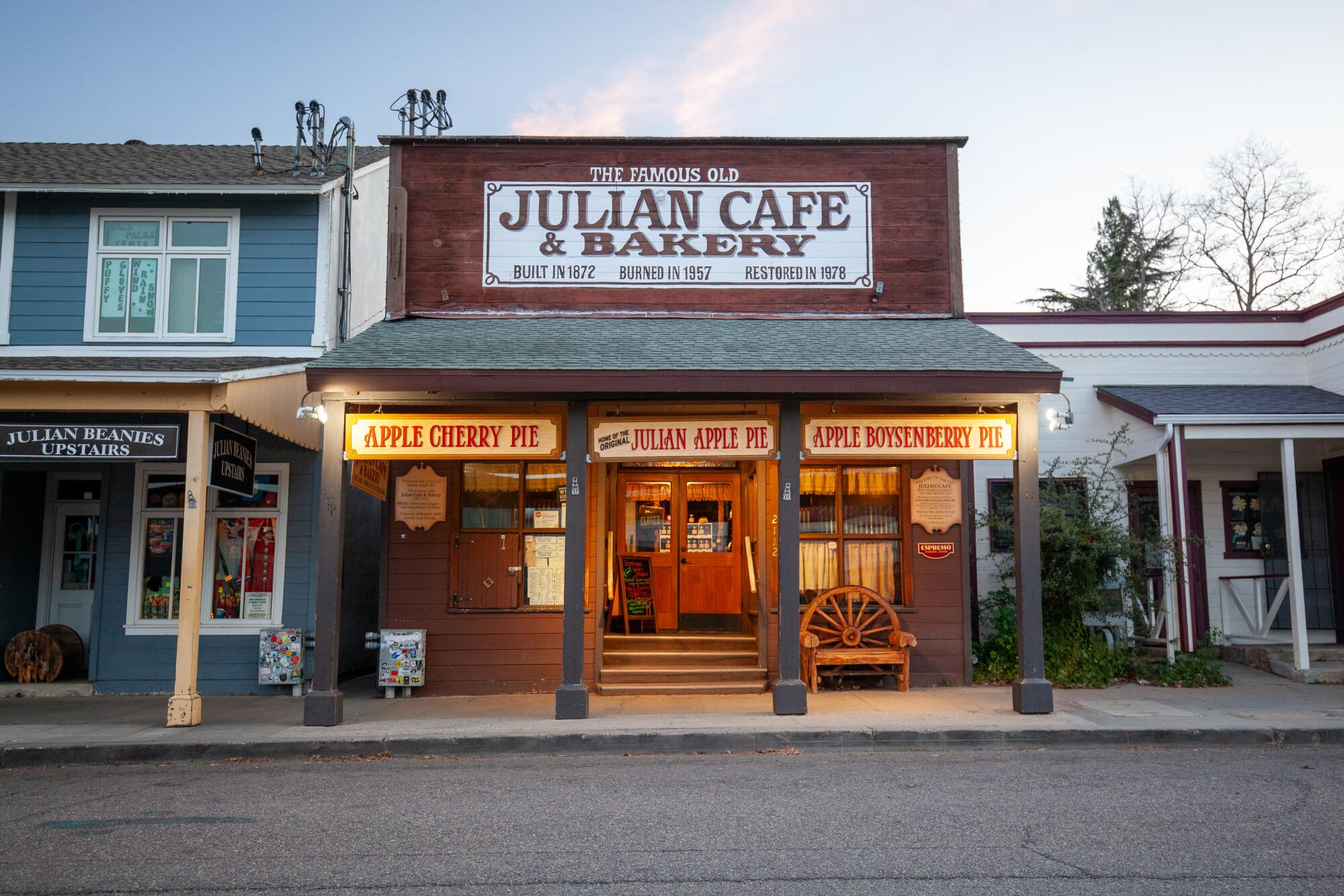
Julian Cafe and Bakery, the start of the trip off Route 78.
(Josh Jackson)
Within minutes of leaving town, the pavement twists downward through tight turns and steep grades as the mountain air begins to warm, the vegetation giving way to chaparral and scattered juniper, then to the stark silhouettes of ocotillo and Mojave yucca. By the time it reaches the Pacific Crest Trail crossing 12 miles east of Julian, travelers have already descended nearly 2,000 feet.
Here, the highway passes quietly into Anza-Borrego, homeland of the Kumeyaay, Cahuilla and Cupeño peoples. At nearly 650,000 acres — just smaller than Yosemite — the park unfolds as a vast mosaic of mountains, badlands and open desert valleys extending far beyond the reach of the pavement.

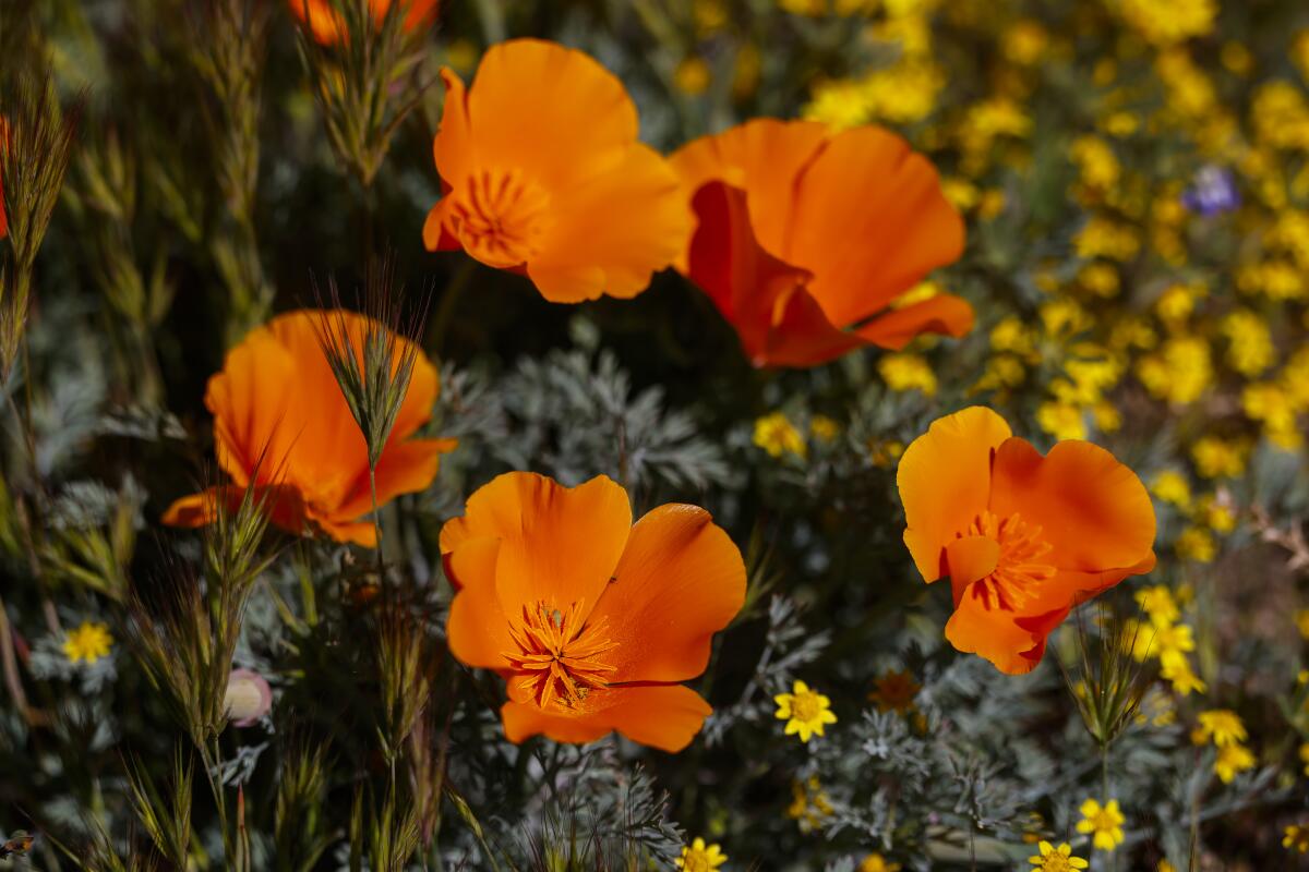
Wildflowers along the route.
(Josh Jackson)
Bri Fordem, executive director of the Anza-Borrego Foundation, said the landscape reveals itself slowly to first-time visitors. “I think a lot of people drive right by it and go, ‘Oh yeah, there’s a desert there,’” she said. “But when you stop and you go a little slower and take a closer look, a whole world opens up.”
That invitation begins at mile 18, where the Yaqui Pass Road turnoff leads northeast toward the desert basin and the gateway community of Borrego Springs. The 2.8-mile Borrego Palm Canyon Trail offers one of the park’s most accessible routes into the desert’s interior. Cholla gardens and brittlebush rise from pale alluvial slopes, and a seasonal stream leads to one of California’s few native fan palm oases.
In wet winters, the valleys beyond town awaken in color as sand verbena, desert sunflower, evening primrose and pincushion gather in brief, luminous blooms across the desert floor. The Anza-Borrego Foundation tracks these seasonal displays and offers guidance on how to witness them responsibly.
The short detour returns to Highway 78 along Borrego Springs Road, where the pavement drops abruptly through the Texas Dip near mile 27 — a stark, cinematic wash where scenes from the closing sequence of “One Battle After Another” were filmed. Wandering through the wash, the mind drifts not to the film but to the flash floods that move through this channel after heavy rains, sudden torrents cutting and reshaping the valley floor in a matter of hours.

Ocotillo plants rise up from the desert floor in Anza-Borrego Desert State Park.
(Josh Jackson)
The sun hangs in the middle of the sky as I drive toward one of the most rapidly changing shorelines in California. From almost any vantage point, the Salton Sea appears lifeless — a gray expanse rimmed with salt and windblown dust. But at its southern terminus, that impression begins to shift. The basin gathers into shallow wetlands where movement returns to the landscape.
Sixty miles from Julian, I turn onto Bannister Road and bump north along a gravel track for three miles into the basin, to a parking lot 164 feet below sea level. The lot sits within Unit 1 of the Sonny Bono Salton Sea National Wildlife Refuge. A short walk along an irrigation canal leads to a weathered observation deck rising two stories above a patchwork of saturated flats where saltgrass, iodine bush and cattail take root. Here, the Pacific Flyway compresses into a living mosaic of wings, water and soil. Each spring, hundreds of thousands of birds gather here to feed and rest before lifting north again, following migratory paths far older than the farms and highways that now define the valley.

The wetlands near the Salton Sea provide a vital habitat for birds.
(Josh Jackson)
The place overwhelms the senses: a wash of emerald against open sky, thousands of snow geese honking in chorus, orange-crowned warblers and Abert’s towhees singing in the trees, and the persistent tang of salt in the air.
I meet three birders standing quietly on the platform, scanning the horizon through binoculars and recounting the 73 avian species they had tallied over the last two days — burrowing owls, American avocets, sandhill cranes and black-necked stilts among them. For 30 minutes we watch a northern harrier on the hunt, dive-bombing blue-winged and cinnamon teal, though he always comes up empty. Between scans of the horizon, we bond over “Listers,” the 2025 documentary that turns obsessive birdwatching into both comedy and a tale of devotion.

A burrowing owl stands in the Sonny Bono Salton Sea National Wildlife Refuge.
(Josh Jackson)
Leaving the refuge, the vibrant color palette and moisture give way to muted browns and the returning austerity of desert air. By mile 97, the road rises to the Hugh T. Osborne Overlook, where the landscape shifts once again, opening into a vast ocean of sand.
The Algodones Dunes stretch toward the horizon in pale, wind-sculpted ridges, a narrow ribbon of shifting terrain running south into Mexico. The highway passes directly through their center.
From the overlook, the road reads as a line dividing two expressions of the same dune system. To the south lie the Bureau of Land Management’s Imperial Sand Dunes, where dune buggies and motorcycles trace arcs across bare slopes. North of the pavement, the North Algodones Dunes Wilderness holds a quieter terrain, where sunflower, ephedra and honey mesquite anchor the sand in subtle defiance of the wind.

A person walks along the Algodones Dunes.
(Josh Jackson)
Here the road becomes a boundary between different ways of moving through — and loving — the same landscape: speed and stillness, noise and silence, crowds and solitude.
By late afternoon, the final miles carry me east toward the Colorado River, where it meanders past willow and cottonwood. The light softened toward sunset, an evening echo of the same violet sky that hovered over Julian at the start of the day. After 140 miles, my road trip had come to an end. Yet as I pitched my tent that night, the motion of the landscapes lingered in mind.
The Colorado continued its long course south. Snow geese lifted north from refuge marshes. Wind reshaped the dunes, erasing the day’s tracks. Wildflowers that had briefly lit the desert floor would soon fade as heat gathered strength. The road ended, but the living systems it crossed moved steadily onward, already turning toward the next season.
Road trip planner: State Route 78

Highway 78 illustrated map.
(Illustrated map by Noah Smith)
The route: Julian to Palo Verde.
Distance: 140 miles (one way).
Drive time: 3 hours straight through; allow a full day for stops.
Best time to go: October through April. Summer temperatures frequently exceed 110 degrees.
Fuel and essentials:
- Julian (Mile 0): Gas station, Julian Market and Deli, lots of restaurants.
- Borrego Springs (Mile 18): Gas station, groceries, cafes.
- Brawley (Mile 74): Gas station, restaurants.
Eat and drink:
Camping:
Lodging:
Hike and explore:
Safety notes:
- Water: Carry at least 1 gallon per person per day.
- Connectivity: Cell service is dependable along the route.
- Wildlife: Watch for bighorn sheep and coyotes on the road, especially at dawn and dusk.

Wildflowers along Highway 78.
(Josh Jackson)