
Costco, Target tie urban expansion to affordable housing boom
Costco, Target tie urban expansion to affordable housing boom
Source link
Costco, Target tie urban expansion to affordable housing boom
Source link

Named for its 19th-century neoclassical church, Notre-Dame du Mont was once a site where sailors who’d survived shipwrecks and storms made offerings of thanks. Now locals and visitors make a pilgrimage to this vibrant quarter for its restaurants, indie shops and street art. Voted Time Out’s coolest neighbourhood in the world in 2024, Notre-Dame du Mont has retained its laid-back charm while continuing to grow, stretching south on Rue de Lodi. Since December 2025, the church’s parvis has been pedestrianised. Removing the urban roar of scooters has returned the quarter to its village-like ambience – best enjoyed on one of the many tree-lined terraces.
The quarter reflects Marseille’s flourishing culinary scene: diverse, convivial and amplified by young chefs like Scot Megan Moore, who cooks up comfort fare with culinary heft at Bonnies. Its playlists and live jazz nights echo the vintage vibe of this former watering hole. For a taste of the Mediterranean, tuck into small plates and natural wines at Nabu & Jéro wine bar.
For food sur le pouce (on the go), check out the huge sandwiches at Razzia, which you can eat while soaking up the sun on their patio. Down the street at Durum, Sofiane Benouamane traded in his chef whites to make Levantine wraps stuffed with the most succulent meats – so gourmet that the tiny snack bar is lauded by the French gastronomic guide Gault & Millau.
Eco-friendly boulangerie Ferments creates baked delights to enjoy with small-batch coffee. For a slice of Marseille’s signature dish, order a wood-fired moitchié-moitchié (half anchovy, half emmental) at La Bella Pizza. Or, follow the scent of freshly baked crust to the Chez Papa pizza truck at the entrance to the Notre-Dame du Mont metro stop.
Food is also on the menu at many of Notre-Dame du Mont’s shops. Provisions’ wooden shelves are laden with an array of foodstuffs, wine and culinary books, including a small selection in English. Stay for a locally sourced lunch in the cosy shop. The fragrant tea library Lorène Millet brims with more than 200 varieties, and – thankfully – expert staff to help you choose.
Mo:stera Concept Store feeds many interests – coffee, plants and books, with a penchant for manga and graphic novels. A pioneer of the neighbourhood, the vintage fashion shop Out of Space is chock-a-block with retro finds for men and women. Digitale Pourpre stocks a well-curated selection of clothes from independent designers, while Digger Club has a funky mix of vintage finds.
Zones is a gallery that spotlights photographers from the city and the region, and owner Alice Ducheix makes photography “more accessible” by selling affordable prints. La Baleine shows arthouse films in its intimate 88-seat cinema plus restaurant.
La Cave à Vinyle is a bar with the feel of hanging out in the living room of a friend who’s obsessed with music and wine; sample natural, biodynamic bottles to an eclectic soundtrack, from French crooner Jacques Dutronc to the West African fusion Rail Band. Garage, one of Marseille’s many comedy clubs, hosts English-speaking comics on Friday nights.
At Rue de Village and Rue de Lodi, marvel at the view of Marseille’s most famous monument – and highest point – La Basilique Notre-Dame de la Garde. Stroll over to Cours Julien, the adjacent district, for urban eye candy. Every facade is painted with colourful street art, including the ever-changing staircase that descends to Cours Lieutaud.
Live like a local in the modern rooms with kitchenettes at the 18-room Maison Juste (doubles from €90). Sister property Grand Juste is a former convent with 50 rooms (sleeping up to six people) and a sunny garden (doubles from €93).
As the spines of the invasive thistle bit into my legs, I worried I had failed.
I had spent hours at my computer staring at maps of northeast Los Angeles in hopes I could develop an urban hike that used existing trails to connect at least four of the area’s parks.
But there I was, standing in a narrow footpath on a hilltop, realizing I’d essentially hit a dead end, because to get into Ascot Hills Park, I would need to trespass (not allowed) or do something dangerous (also not allowed).
I headed down the steep hillside and told myself, “It’s OK. It’s your job to fail a little.” It was time to try again!
Sign up to get expert tips on the best of Southern California’s beaches, trails, parks, deserts, forests and mountains in your inbox every Thursday
By continuing, you agree to our Terms of Service, which include arbitration and a class action waiver. You agree that we and our third-party vendors may collect and use your information, including through cookies, pixels and similar technologies, for the purposes set forth in our Privacy Policy such as personalizing your experience and ads.
In today’s edition of The Wild, I will introduce you to a 13.5-mile urban hike that I developed and fact-checked myself from the ground. I have admittedly been a mountain hiking snob since arriving in L.A., running off to the San Gabriels or Santa Monicas any chance I get. This experience opened my eyes to the joy and potential of urban hiking. I’m so excited to share what I learned with you.
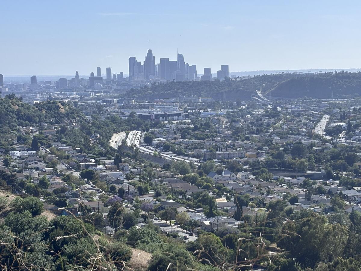
I was inspired to develop this route for a few reasons. For one, I love going to Ernest E. Debs Park and Elephant Hill Open Space, and because I could see one park from a hilltop in the other, I’d wondered: “Could these be connected?”

A view of downtown L.A. and the surrounding city, as seen from the City View Trail in Ernest E. Debs Park.
(Jaclyn Cosgrove / Los Angeles Times)
Secondly, I attended the California Trails & Greenways conference earlier this month where I learned in sessions about hikers connecting existing trails, including San Francisco’s Crosstown Trail and the American Discovery Trail, which I wrote about in last week’s Wild.
Each time I visit one of L.A.’s open spaces, I am in awe of how hard local residents fought to protect the space and how each space has a dedicated fleet of volunteers lovingly restoring it to its glory by ripping out invasive plants (like thistles) and bringing back oaks, sumac and gorgeous wildflowers.
Some quick logistics before I dive into the route:

Elephant Hill Open Space and the San Gabriel Mountains, as seen from near Ascot Hills Park.
(Jaclyn Cosgrove / Los Angeles Times)
Now let’s talk more about the route.
To begin my “River to the Hilltops” hiking adventure, my friend Patrick and I met last week at the entrance of Flat Top Park, parking on the shoulder of the north side of Montecito Drive. Our plan was to check the route I’d mapped out from Flat Top to Rose Hill Park, Ernest E. Debs Regional Park and the Arroyo Seco. I planned to walk the rest of the route a few days later.
Neither of us had been to Flat Top, an open space of more than 120 acres with several private owners. Local residents have advocated for years for Flat Top to be turned into a public park. North East Trees, a local environmental justice group, manages about 37 acres of the site that feature trails and native plant installations.

A snake skin hangs atop buckwheat in Flat Top Park.
(Jaclyn Cosgrove / Los Angeles Times)
From the gate, we trekked southwest along its wide dirt path. Patrick soon spotted a buckwheat plant with a snake skin draped over it, a gift from a previous visitor for all to appreciate.
We headed onward and were greeted by the park’s panoramic views of L.A. County and the San Gabriel Mountains. It’s a quiet respite in the middle of the city.
As we left Flat Top, we spotted a large gopher snake that we both mistook for a rattler. Our day was already off to a cool start!
We traveled northeast on Montecito Drive, watching for cars while observing interesting stilt houses and one home that reminded us of Storybook architecture. Just over half a mile from Flat Top, we found the trail I’d noticed in my research. Its entrance has two barriers in the middle that I interpreted as an attempt to keep out motorized vehicles.
The narrow dirt footpath, called Rose Hill Link Trail on some maps, featured multiple Southern California black walnut trees and at least two healthy Canary Island palms. I paused Patrick mid-sentence because I really wanted to know who was providing us with such loud birdsong. It was a mix of house finch and red-whiskered bulbul.

Weeds crowd the Rose Hill Link Trail, but it remains passable.
(Jaclyn Cosgrove / Los Angeles Times)
Portions of the trail were overgrown with castor bean and other invasives, but some park workers or kind volunteers are doing their best to keep it clear enough to pass.
We took a quick detour to Rose Hill Park in search of a restroom. Both facilities with flush toilets were closed as of Saturday, but there are portable toilets with a hand-washing station.
We headed north from Rose Hill Park onto a steep, direct route to Peanut Lake, a small pond with benches, shade and turtles. We walked around the pond clockwise and took a route on the north end of the pond to continue northward.
After just a tenth of a mile from the pond, we turned left (or west) onto the aptly named City View Trail. The route started to descend steeply after just a third of a mile. I criss-crossed the path to create my own switchbacks, which helps with gaining traction and makes traveling downhill easier on your joints.
We did not take the first left turn off the City View Trail because a hiker carrying a toddler on their back told us it was kind of steep — and they seemed more hardcore than we were. Instead, you’ll find my route suggests you take the Scrub Jay Trail, the second left turn from the City View Trail.

Wild writer Jaclyn Cosgrove and friend Patrick crab-walk down the river embankment.
(Jaclyn Cosgrove / Los Angeles Times)
Patrick and I actually took a different path because I thought the map had suggested there was an entrance to the Arroyo Seco Bike Path from near South Avenue 52. I can’t recommend that option, as it involves an unofficial trail and crab-walking down the side of the concrete river bank.
Instead, you’ll essentially follow the Scrub Jay Trail to a road that leads hikers past the Audubon Center at Debs Park and onto Griffith Avenue. There’s a crosswalk you can take across to an actual entrance to the river bike path.
We ended our day here, taking a rideshare car back to our vehicles. Our driver was curious enough about our day to want to subscribe to The Wild to learn more. I felt that was a good sign!
A few days later, I walked about 9.2 miles to check the rest of the route. I walked up steep hills through South Pasadena before passing through a green space (with a significant history) and into El Sereno. Soon, after chatting with a resident feeding her beloved speckled hens some fresh fruit and complimenting a man’s classic restored truck, I arrived at Elephant Hill Open Space.

The view of downtown L.A. from a high point at the Elephant Hill Open Space in El Sereno.
(Jaclyn Cosgrove / Los Angeles Times)
Elephant Hill is a 110-acre open space with around 200 landowners, although an increasing number are selling their land to the public Mountains Recreation and Conservation Authority.
The agency has worked with community activists to develop the open space’s first official hiking trail, which I had the pleasure of hiking before the grand opening this Saturday. I trekked past the L.A. Conservation Corps workers and contractors busily working to complete the new path. Boulders and oak trees along gates to tamp down illegal off-roading have been added to the space.
After saying hello to a friend who lives nearby, I took Collis Avenue for two blocks and turned onto Yoakum Street, a dirt path, up to Harriman Avenue.
I followed the path labeled “Elephant Hill/Ascot Hills Connector” on my map, where I foraged for a Diet Coke and pretzels at a convenience store and grabbed a poetry book from a free book rack outside Son of a Vet thrift shop. There are many perks to urban hiking!
Soon, I faced my next surprise.

A metal stool sits along a trail in Debs Park where hikers can see great views of L.A.
(Jaclyn Cosgrove / Los Angeles Times)
For reasons unclear to me, someone labeled a spot north of Ascot Hills as the “Ascot Hills Northern Trailhead.” Maybe they were manifesting what could someday be a great walk, because what I found was not a trail I’d repeat.
As I mentioned up top, I hoofed up through thistle and dried-out mustard, thinking I’d find a connection to the well-maintained trails I knew were in Ascot Hills Park. I got to about here, and although I could see the park’s actual trails, I could not safely or legally reach them. Cursing, whining, bemoaning, I made it back down the path that was about a 20% grade.
I stood in the neighborhood, looking like a sad weirdo with a backpack. I decided to try one last thing. It looked like, from the map, there was a northern entrance.
I headed west on Bedilion Street and then turned south onto Bowman Boulevard. After two-tenths of a mile, I turned west onto Lynnfield Street. On the fence, I noticed a wooden sign with green, white and red letters. “Victor’s Walk starts here,” it read.

A memorial for a neighbor near Ascot Hills.
(Jaclyn Cosgrove / Los Angeles Times)
“Who was Victor?” I asked a resident cleaning the street.
He told me that Victor had died recently. He’d helped Victor, who walked daily, keep the street tidy by tending to the plants and picking up trash, and he was doing his best to make his late neighbor proud. We chatted more, and he confirmed that there was a nearby way to reach Ascot Hills. (He’d helped other hikers who’d taken the thistle-filled route.)
I soon found a locked gate with access for hikers, and farther down a paved road and a razor-wire-lined fence, an opening to the park.

Ascot Hills Park in Northeast L.A.
(Jaclyn Cosgrove / Los Angeles Times)
Reaching a vista point, I took in the views of downtown L.A. and the rest of the city, grateful for my first visit to the park and the people I met along the way to get there.
Before finishing the final 2.6 miles, I stopped at the Village Mart & Deli near Ascot Hills for a sandwich.
The rest of my day included more life-affirming surprises.

Lincoln Park in Los Angeles.
(Jaclyn Cosgrove / Los Angeles Times)
I reached Lincoln Park as a Union Pacific train rumbled past. A Muslim man performed his late afternoon prayer with his mat under a shade tree. Kids played baseball in an adjacent field. I followed the concrete path to the lake, where I navigated around ducks and geese and watched a fisherman catch a bass.
Continuing north, I stopped at the Wall Las Memorias AIDS Monument and ran my fingers over the names etched into one of the panels honoring the dead. I felt chills as I took in the reverence for human life communicated in the memorial’s art and design. I hope you’ll stop by as a part of your walk too.

The entrance to the Wall Las Memorias AIDS Monument in Lincoln Park.
(Jaclyn Cosgrove / Los Angeles Times)
I had fooled myself into believing the end of my walk would be easy — like somehow I’d gently ride off into the sunset.
Instead, after taking Gates Street to North Broadway, I looked up to discover what I told a friend in a text message was my “final boss”: North Thomas Street. In just under a third of a mile, the street gains about 260 feet, similar in steepness to the start of a challenging mountain trek.

North Thomas Street, a steep road along the 13.5-mile path.
(Jaclyn Cosgrove / Los Angeles Times)
I rallied, reminding myself of the time I walked all 27.4 miles of Washington Boulevard in one day, and headed up. Just under half a mile in, I reached the top. I thrust my arms into the air and cheered like I’d won a race.
Ever since moving to L.A., I’ve been blown away by just how many people truly care about our public lands and open spaces. It has taken decades for the parks on this route to be as protected as they are, although much of the space remains threatened by development.
My route is a kind of thank-you to those of you who’ve been doing this work. I hope more people see it, appreciate it and want to show their gratitude too.


Stargazers observe the celestial bodies at the Star Party, hosted by the Los Angeles Astronomy Society, last year.
(Carlin Stiehl / For The Times)
1. Jump for Jupiter in Silver Lake
The Los Angeles Astronomical Society will host a free star party from 8 to 10:30 p.m. Thursday at the Sunset Triangle Plaza in Silver Lake. Guests will listen to local musicians while hopping among telescopes. Learn more at the group’s Instagram page.
2. Notice the nighttime critters in Orange County
We Explore Earth will host a 3-mile nocturnal wildlife hike from 7 to 9 p.m. Saturday through Black Star Canyon about 15 miles east of Santa Ana. Hikers will look for evidence like burrows, nests and tracks of tarantulas, toads, scorpions, glowworms and other nighttime creatures. The trek is along a wide dirt trail with minimum elevation gain. Register at eventbrite.com.
3. Hike in solidarity and support in Claremont
Hiking With Bill, a sober hiking group, will host a hike at 7 a.m. Saturday at Claremont Hills Wilderness Park. The group aims to provide a safe, sober and supportive community outdoors experience. To learn more about the group’s exact meeting location, either email hikingwithbill935@gmail.com or visit the group’s Instagram page.


An opening date for later this year was announced at the Wallis Annenberg Wildlife Crossing in Agoura Hills on April 22.
(Christina House / Los Angeles Times)
Apparently, social media still has the power to create sudden outrage over seemingly the most random of targets: the Wallis Annenberg Wildlife Crossing. Times staff writer Lila Seidman wrote that after a conservative think tank dubbed the bridge a $114-million “bridge to nowhere,” conservative media and politicians jumped on the opportunity to criticize the effort (and Gov. Gavin Newsom, a Democrat considering a presidential run). Curiously, the bridge is a fourth of the cost of President Trump’s White House ballroom — as the bridge’s original price has increased in part due to worsening inflation and tariff-driven price increases. The bridge is set to open Dec. 2.
Happy adventuring,

Although I find most trails around L.A. County are largely free of litter, I have seen metallic balloons deep within the San Gabriel Mountains, far beyond wherever they were released. I wasn’t surprised when I saw, via a post from Steampunk Farms Rescue Barn, a Ranchita-based farmed animal sanctuary, that the balloons can make it far into the Mojave too. The image of a desert tortoise considering a lunch of a “Congrats, Grad!” balloon still made my stomach lurch. The organization asked readers to consider: “Don’t release balloons. Any of them — mylar, latex, ‘biodegradable,’ sky lanterns. Weight them, pop them, recycle them indoors,” among other helpful ideas.
For more insider tips on Southern California’s beaches, trails and parks, check out past editions of The Wild. And to view this newsletter in your browser, click here.