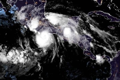
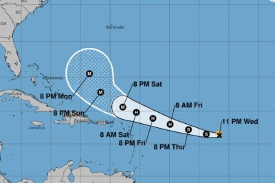
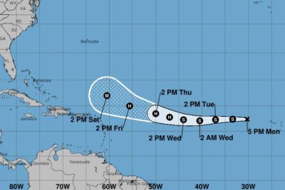
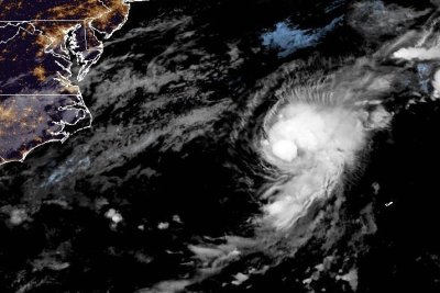
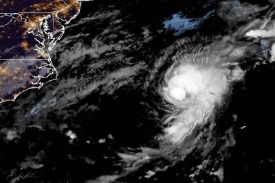
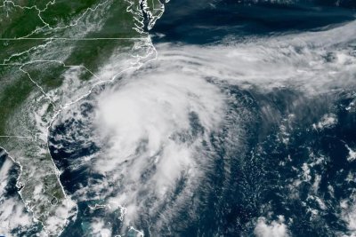
tropical

Tropical Storm Erin forecast to be hurricane by Friday

Tropical Storm Erin is forecast to become a hurricane by 8 a.m. Friday and a major one by 8 p.m. Sunday. Image by National Hurricane Center

Aug. 13 (UPI) — Tropical Storm Erin is slightly intensifying and forecast to become a hurricane on Friday morning over the central tropical Atlantic with a chance of ultimately affecting the U.S. East Coast, the Bahamas and Bermuda next week, the National Hurricane Center said Wednesday.

For the first time since Erin became a tropical storm Monday morning, intensity increased, though just 5 mph, to maximum sustained winds of 45 mph, with gradual strengthening during the next two days forecast, the NHC said in its 5 p.m. EDT update.

In the 11 p.m. update, Erin remained at 50 mph.

Erin is forecast to reach hurricane status by 8 a.m. Friday with winds at least 74 mph, and a major hurricane, with winds of at least 111 mph, by 8 p.m. Sunday.

It would be the first hurricane of the Atlantic season. Beryl was the first hurricane last year on June 24.

The storm is about 1,095 miles east of the Northern Leeward Islands.

Erin was moving westward at 16 mph and will shift to a north-westward track beginning Thursday night and into the weekend, the NHC said. On the forecast track, the storm’s center will move over or near just north of the northern Leeward Islands.

The NHC’s “cone” doesn’t track Erin past Monday night, and NHC forecasters remind that they have an average error of 150 to 214 miles at days four and five.

In the latest discussion, NHC forecaster Jack Beven said there is a “greater than normal uncertainty about what impacts Erin may bring to portions of the Bahamas, the East Coast of the United States and Bermuda.”

But he said: “The risk of dangerous surf and rip currents across the western Atlantic basin next week is increasing.”

By this weekend, swells are forecast to cause life-threatening surf and rip current conditions, the NHC said.

Alex Sosnowsky, an AccuWeather senior forecaster, said there is concern that residents, visitors, cruise lines, and shipping and fishing ventures “could pass paths with a powerful hurricane.”

With a track farther to the east, Bermuda could be directly in the path as a major hurricane.

He said a farther west scenario would mean a greater risk of strong winds, rain and coastal flooding in the U.S., including eastern North Carolina, Long Island, New York and southeastern New England.

“Families heading to U.S. Atlantic beaches for a late-summer vacation next week need to be extremely cautious when venturing into the surf,” AccuWeather Lead Hurricane Expert Alex DaSilva said. “More than 50 people have lost their lives to rip currents and rough surf at beaches across the country so far this year, without any major hurricane nearby.”

There are no warnings or coastal watches in effect as tropical-force winds extend outward up to 60 miles. But those in the northern Leeward Islands, the Virgin Islands and Puerto Rico should monitor Erin’s progress.

The previous four named Atlantic storms this year were Andrea, Barry, Chantal and Dexter. None of them became hurricanes, and Chantal was the only one to make landfall in the United States, causing significant flooding in North Carolina.

Helene struck that state last year as a tropical storm, causing an estimated $53 billion in damage, after hitting western Florida as a Category 4 hurricane.

Four other hurricanes made landfall in the United States in 2024: Beryl, Debby, Francine and Milton.

Source link

Fast-moving Tropical Storm Erin heads toward U.S., Caribbean

Tropical Storm Erin is forecast to become a hurricane on Thursday. Image by National Hurricane Center

Aug. 11 (UPI) — Tropical Storm Erin is moving quickly and forecast to become the first hurricane of the Atlantic season by the “latter part of this week,” the National Hurricane Center said Monday.

Erin had maximum sustained winds of 45 mph and was moving west at 21 mph, according to the NHC in a 5 p.m. EDT update. That was the same strength three hours earlier when the NHC announced the fifth named storm of the season.

Erin was about 430 miles west-northwest of the Cabo Verde Islands in the central Atlantic Ocean near west Africa.

NHC added Erin’s storm coordinates show it heading west while some 2,155 miles east of the Northern Leeward Islands to the Caribbean.

“It is still too early to determine what impacts, if any, Erin may bring to the northern Leeward Islands, Bermuda, or the east coast of the United States,” NHC forecaster Philippe Papin said in a discussion.

An NHC tracking map shows Erin becoming a hurricane by Wednesday. It is then forecast to turn to the northwest from Thursday to Friday and become a major storm on Saturday.

Papin said that “Erin’s structure this afternoon looks like a tropical cyclone that is struggling with the nearby thermodynamic environment, with only a small patch of deep convection pulsing near the estimated center.”

Chad Merrill, an AccuWeather senior meteorologist, said: “Several factors are working in its favor, including lack of dust, warm water and a lack of disruptive breezes (wind shear).”

People in Bermuda and the Bahamas should closely monitor Erin’s progress, Merrill said.

There are no coastal watches or warnings in effect given how far out to sea the storm is now. Tropical force winds extend outward up to 35 miles from the center.

“It is far too early to determine what, if any, impacts for southeast Georgia and northeast Florida,” NWS Jacksonville said Monday.

The previous four named Atlantic storms this year were Andrea, Barry, Chantal and Dexter. None of them became hurricanes, and Chantal was the only one to make landfall in the United States, causing significant flooding in North Carolina.

Helene struck that state last year as a tropical storm, causing an estimated $53 billion in damage, after hitting western Florida as a Category 4 hurricane.

Four other hurricanes made landfall in the United States in 2024: Beryl, Debby, Francine and Milton.

Source link

South Korea breaks 117-year record with 22 ‘tropical nights’ in July | Climate Crisis News

At least 16 people have died from heat-related illnesses in South Korea this year, according to health authorities.

South Korea has shattered a 117-year record for the number of sweltering nights in July amid a scorching heatwave.

Temperatures in Seoul did not dip below 29.3 degrees Celsius (84.7 degrees Fahrenheit) overnight, marking the 22nd “tropical night” so far this month, the Korea Meteorological Administration (KMA) said on Thursday.

The KMA defines a tropical night as occurring when temperatures stay above 25 degrees Celsius (77 degrees Fahrenheit) from 6:01pm to 9am the following day.

The number of tropical nights in July is the highest since records began in 1908.

The previous record for July was 21 tropical nights, set in 1994.

South Korea has been grappling with blistering heat over the past week, with daily temperatures surpassing 40 degrees Celsius (104 degrees Fahrenheit) in some parts of the country.

At least 16 people have died from heat-related illnesses so far this year, according to the Korea Disease Control and Prevention Agency (KDCA).

The milestone continues a recent trend of scorching temperatures across Asia, as scientists warn that human-driven climate change is increasing the frequency of extreme weather.

On Wednesday, Japan said it experienced its hottest day in recorded history after the mercury hit 41.2 degrees Celsius (106.16 degrees Fahrenheit) in Tamba city, Hyogo prefecture.

Earlier this month, Japan and South Korea both reported that June this year was the hottest on record, while China’s National Climate Centre said the country had experienced a record number of days with temperatures of 35 degrees Celsius (95 degrees Fahrenheit) or above since mid-March.

In India, the National Disaster Management Authority last month issued a red alert for New Delhi after the heat index – which looks at temperature and humidity to measure perceived temperature – hit 51.9 degrees Celsius (125.4 degrees Fahrenheit).

In April, Myanmar’s weather agency said the country experienced the hottest day ever recorded for the month when the mercury hit 48.2 degrees Celsius (118.8 degrees Fahrenheit) in the central town of Chauk.

While climate change is a concern worldwide, Asia has been particularly susceptible to extreme temperatures, according to scientists.

In its latest climate report released last month, the World Meteorological Organization said Asia was warming nearly twice as fast as the global average.

The average temperature of Asia’s landmass last year was about 1.04 degrees Celsius (33.87 degrees Fahrenheit) above the 1991-2020 trend, according to the WMO, making 2024 either the warmest or second warmest year on record, depending on the dataset used.

Source link

‘I couldn’t sit up after catching suspected tropical disease’

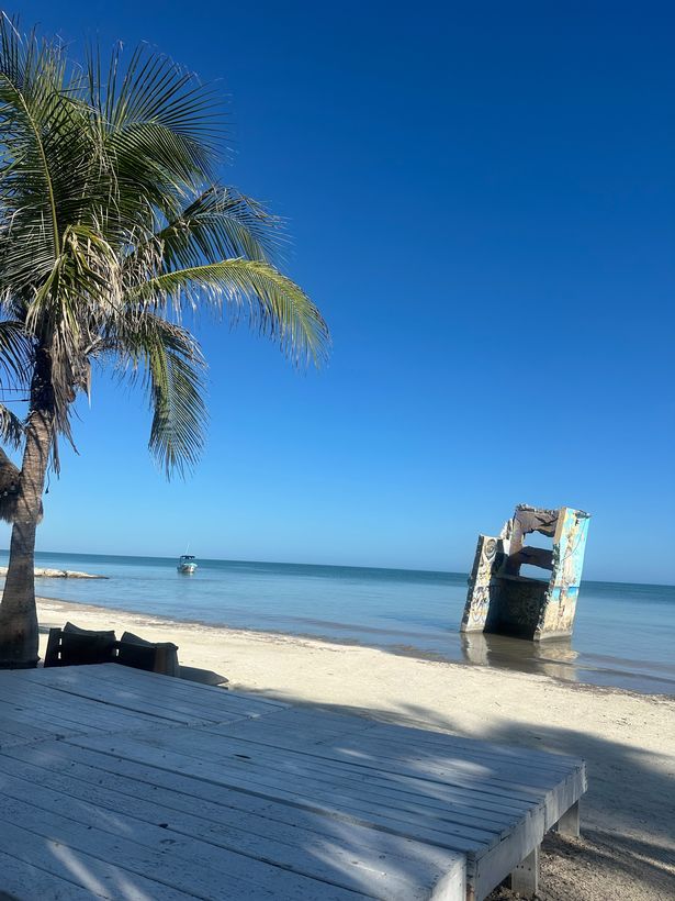
Laura Angulo was visiting the Philippines as part of a four-month trip around South East Asia when she became ill

Laura Angulo
Laura Angulo was ill for weeks(Image: Jam Press)

A teacher was left “unable to sit up” after falling ill with suspected dengue fever during a nightmare holiday. Laura Angulo was touring the Philippines on a four-month South East Asia adventure when she became unwell on Palawan Island.

The 29-year-old keen globetrotter initially suffered from “general malaise and fatigue”. However, Laura’s health rapidly worsened.

“I remember we were on a beach and I was lying down eating ice cream because I didn’t have the strength to sit up,” Laura, who lives on Australia’s Gold Coast, shared with What’s The Jam. “The moment I started vomiting, we decided to go to the doctor, since we knew that in the Philippines, as in many other tropical countries, you can get dengue fever.”

Laura, originally from Spain, underwent a blood test which revealed “a very low percentage of platelets”.

She recalled: “They told us that this is one of the symptoms of dengue fever and that I probably had it. At that moment, I admit I was terrified.

“I called my parents and they asked me to return to Spain. But, luckily, my sister and cousin were there for me when I needed them.

Laura Angulo
Laura Angulo is a keen traveller(Image: Jam Press)

“Doctors then performed another test on me, which came back negative, but that didn’t mean I wasn’t infected. I was able to go back to my hostel, but I had to return over the next three days for further tests to see if my diagnosis had improved, since one of the possible symptoms of dengue is internal bleeding

“During those three days, the vomiting and diarrhoea worsened, but I didn’t have any other symptoms. I was drinking saline and eating small amounts of rice and chicken when my body allowed it.

“On the third day, we had to travel to another island where I felt ill for two or three weeks and I lost about 1.6 stone (10kg). It was never confirmed whether I was actually infected, but my platelet count suggests I was.”

Laura Angulo
Laura Angulo(Image: Jam Press)

Laura, who has more than 50,000 followers on Instagram and TikTok, shared with her online audience that dengue is spread by mosquito bites.

She continued: “There are four different strains of the dengue virus and if you’ve had one of them and become infected again, your risk of severe symptoms increases. If you get bitten by two strains of dengue at the same time, internal bleeding and possibly death become more likely.

“But don’t be alarmed; the Philippines is a beautiful country that I highly recommend visiting. To prevent something similar from happening, my first recommendation is to go to a vaccination centre and always carry mosquito repellent and basic medicines as well as travel insurance. Remember to get informed beforehand, and travel responsibly.”
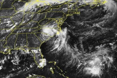
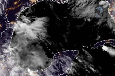
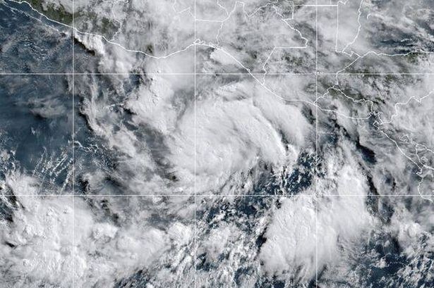
Source link

Tropical Storm Chantal drenches Carolinas, closes I-95

Tropical Storm Chantal moved onshore in the Carolinas early Sunday, and is expected to dump as much as 5 inches of rain on the region as it moves inland through the day on Monday. Photo courtesy of the National Weather Service

July 6 (UPI) — Tropical Storm Chantal dumped heavy rain on South Carolina early Sunday before weakening to a depression as it came ashore.

The third named storm of the year, Chantal came ashore near Litchfield, S.C., about 3 a.m. before being downgraded. The National Weather Service said the center of the storm was hard to determine as it began to diffuse after arriving onshore.

Winds peaked at 60 mph before coming ashore, the National Hurricane Center said. The storm had moved inland about 80 miles west of Wilmington, N.C., moving north at about 9 mph. Its sustained winds, however, had fallen off to about 35 mph.

Flash flooding remained a concern and prompted local areas to take precautions as forecasters predicted that as much as four inches of rain could drench the region into the day Monday.

“1-3 inches of rain has already fallen in isolated locations across Eastern NC,” the Newport/Morehead City office of the NWS said in a social media post. “Expect 1-1.5 additional inches through Monday, with locally higher amounts of 3+ possible. This could lead to localized flash flooding.”

Heavy rain forced the closure of some lanes of Interstate 95 as it moved inland, forcing travelers to take alternate routes to reach their destinations.

The storm prompted isolated tornado threats, but the storm was not expected to threaten North Carolina’s popular Outer Banks area. The risk is, however, high for a dangerous rip current across eastern North Carolina through Sunday night.

Source link

Tropical Storm Chantal forms, forecast to reach Carolinas by Sunday

1 of 2 | Tropical Storm Chantal became the third named storm in the Atlantic this season. Photo by National Oceanic and Atmospheric Administration.

July 5 (UPI) — Tropical Storm Chantal formed in the Atlantic on Saturday morning and is projected to reach South Carolina and North Carolina on Sunday, the National Hurricane Center said.

Chantal, the third named storm of the season, will be the first system to impact the United States this Atlantic hurricane season, which began June 1.

“As tropical cyclones go, this storm will be relatively minor and short-lived,” Frank Strait, severe weather liaison with the South Carolina State Climate Office, told the Island Packet.

In the 2 p.m. EDT update, Chantal had maximum sustained winds of 45 mph and was traveling northward at 3 mph. In the 11 a.m. update, the winds were 40 mph.

The storm became a tropical depression Friday night off the coasts of Northeast Florida and Georgia.

Chantal was about 105 miles south-southeast of Charleston, S.C., and about 185 miles south-southwest of Wilmington, N.C.

A tropical storm warning is in effect for the South Santee River, S.C., to Surf City, N.C. A tropical storm watch goes from Edisto Beach to South Santee River.

Tropical-storm-force winds extend outward up to 105 miles east of the center.

“Chantal has barely moved since last night, but a motion to the north-northwest is expected to begin soon,” NHC forecasters said. “The main steering features appear to be a mid- to upper-level low over the Gulf and a narrow mid-level ridge across the mid-Atlantic region.”

Some strengthening is expected before Chantal reaches the coast, NHC said.

A turn to the northeast is forecast by Sunday night, NHC said. On the forecast track, the center of Chantal is expected to move across South Carolina’s coast Sunday morning.

Chantal is expected to produce heavy rainfall in the Carolinas through Monday with 2 to 4 inches and local amounts of 6 inches. NHC said these rains could cause flash flooding

“The combination of storm surge and tide will cause normally dry areas near the coast to be flooded by rising waters moving inland from the shoreline,” NHC said.

Storm surge is forecast at 1-3 feet from South Santee River to Surf City and 1-2 feet from Edisto Beach to South Santee River.

Also, isolated tornadoes are possible Saturday night into Sunday along South Carolina’s eastern coast and much of North Carolina, NHC said.

“This was a classic example of homegrown development, by which a tropical storm formed close to the southeast Atlantic coast and in an area where it is typical for July,” AccuWeather Lead Hurricane Expert Alex DaSilva said.

Andrea and Barry, the first two named systems of the Atlantic hurricane season, have dissipated.

Source link

Barry makes landfall in eastern Mexico as tropical depression

Barry made landfall along the eastern coast of Mexico as a tropical depression on Sunday night. Photo courtesy of NOAA/Website

June 29 (UPI) — Barry made landfall as a tropical depression off the eastern Gulf Coast of Mexico on Sunday night, and was expected to bring heavy rains and flash flooding to the North American nation over the next few days.

Barry was located about 15 miles south-southeast of Tampico, on Mexico’s eastern coast, in the Gulf of Mexico, with maximum sustained winds of 35 mph, the National Hurricane Center said in its 10 p.m. CDT update.

It was moving northwest at 9 mph.

A tropical storm warning had been in effect for the Gulf Coast of Mexico from Boca de Catan southward to Tecolutla has been canceled.

“The primary impact with Barry remains heavy rainfall and flash flooding for the upslope areas of eastern Mexico,” the NHC said in a discussion on the storm.

Between 3 and 6 inches of rainfall are expected with isolated maximum totals of 10 inches across the Mexican states of Veracruz, San Luis Potosi and Tamaulipas through Monday, forecasters said.

“This rainfall may produce life-threatening flooding and mudslides, especially in areas of steep terrain,” it said.

Tropical Depression Barry is the second named storm of the Atlantic hurricane season.

The National Oceanic and Atmospheric Administration is forecasting between 13 and 19 named storms for this year.

Source link

Tropical Storm Barry to make landfall soon in eastern Mexico

June 29 (UPI) — Tropical Storm Barry was nearing the eastern Gulf Coast of Mexico on Sunday evening, and was expected to bring heavy rains and flash flooding to the North American nation over the next few days.

Barry was located about 60 miles southeast of Tampico, on Mexico’s eastern coast, in the Gulf of Mexico, with maximum sustained winds of 45 mph, the National Hurricane Center said in its 7 p.m. CDT update.

It was moving northwest at 8 mph and was on track to make landfall in the next few hours, before moving inland over eastern Mexico Sunday night.

A tropical storm warning is in effect for the Gulf Coast of Mexico from Boca de Catan southward to Tecolutla.

It is not expected to intensify much more before making landfall, and weakening is forecast to begin shortly after it moves inland, according to a NHC discussion on the storm.

“The primary impact with Barry remains heavy rainfall and flash flooding for the upslope areas of eastern Mexico,” the NHC said.

Between 3 and 6 inches of rainfall are expected with isolated maximum totals of 10 inches across the Mexican states of Veracruz, San Luis Potosi and Tamaulipas through Monday, the forecasters said.

“This rainfall may produce life-threatening flooding and mudslides, especially in areas of steep terrain,” it said.

Tropical Storm Barry is the second named storm of the Atlantic hurricane season.

The National Oceanic and Atmospheric Administration is forecasting between 13 and 19 total named storms for this year.

Source link

‘I visited lesser-known tropical island with 32C temps and it was so cheap’

This little-known Mexican island completely blew me away with its dream-like beaches, affordable prices and wealth of fauna including tropical birds, flamingos and monkeys

Beach beds and hammocks among palm trees at perfect tropical coast on Holbox island in Mexico
This tropical island paradise was very affordable(Image: Getty Images/iStockphoto)

When booking a trip to Mexico, a lot of people flock to the touristy hotel zone in Cancun – but I wanted to veer off the beaten track and stay somewhere more affordable.

So I hopped on a two-and-half bus ride from Cancun’s centre to the port town of Chiquila, on the east tip of the peninsula. From there, I took the ferry to to the lesser-known island of Holbox. I’d heard it was a ‘hidden gem’ and it was recommended on comment threads and backpacker blogs. They promised white-sand beaches, electric Caribbean waters, and mouth-watering Mexican cuisine. It completely blew me away.

Isla Holbox was once a small fishing village, with little more than 100 families and a dozen hotels nestled on its sandy soil. It’s now been expanded to fit even more rooms, hostels and restaurants – but doesn’t feel in any way crowded.

Holbox
Playa Holbox has beautiful white sand

READ MORE: Millions of Brits are forgoing travel insurance but my holiday nightmare shows you need it

My boyfriend and I opted to stay in a private room in Che Holbox, a modern-feeling hostel just 10 minutes’ walk from the island’s main beach. It cost just £28 per night, with a pool, bar and (crucially) air-conditioning.

As an island on the Caribbean Sea, Holbox is hot: but its proximity to the azure waters completely negates the heat. Shade can be found under gently wafting palms and ducked under market tents. Wandering down its sandy streets, there are hardly any cars – though tourists and locals may trundle past in golf buggies.

As you stroll into the main town there are endless options for food: taquerias, brunch bars, seafood restaurants. On our first morning, we enjoyed a mouthwatering breakfast by the beach with strong American coffee and huevos motulenos: eggs with beans, salsa and fried banana. In the morning, there were hardly any other beachgoers, meaning we could listen to the tropical caws of the great-tailed grackles and the soft lap of the waves as the heat began to stir.

Holbox
Holbox village contains colourful buildings (Image: Getty Images)

While many parts of Mexico’s Mayan Riviera (which includes Cancun) can become bombarded by saragassum during the summer months – a sulfuric smelling thick brown seaweed – its presence was scarce on Holbox’s shores, allowing you to enjoy an idyllic view.

During the day, we went on a cycling trip through the island to Punta Mosquito: a beach further north where you could spot flamingos. Wading through the warm water, there were several sand banks, meaning you could walk out for a while without needing to swim (although I did spot a sting rays I was careful not to step on).

Punta Mosquito
Punta Mosquito, Isla Holbox

While traversing the beach, we also passed by the island’s large protected wildlife zone, the Yum Balam Reserve. Home to glistening lagoons, mangroves, jaguars, crocodiles, monkeys and turtles, it costs around just £8 for visitors to enter.

After cycling to Playa Punta Cocos, we refreshed ourselves with coconut milk by the beach, followed by margaritas rimmed with lip-licking salt and spice. We also ordered a fresh bowl of guacamole with nachos, while an iguana rested on the tree branch next to us. For the most part, cocktails in bars and restaurants cost around £5, while beers were between £2-3.

Whale shark
You can swim with whale sharks on Holbox(Image: AFP via Getty Images)

While we took it easy, there are countless other activities that holidaymakers can get up to. Holbox is one of the few places in the world where you can swim with whale sharks. Despite their name, these giant sea creatures are known for being very gentle.

There is also a bioluminescent beach, which shows up best during summer months, and which visitors can come to admire once the sun sinks behind the horizon and the sea is lit up by thousands of tiny plankton.

Source link

Erick downgraded to a tropical storm

June 19 (UPI) — Hurricane Erick made landfall in southern Mexico with powerful winds Thursday morning, but has been downgraded to a tropical storm and is expected to dissipate during the overnight hours.

The National Hurricane Center on Thursday afternoon reported Erick had moved over the Mexican state of Guerrero along the country’s Pacific coast, about 35 miles north-northeast of Acapulco.

A tropical storm warning is in effect from Punta Maldonado to Tecpan de Galeana, with sustained winds of around 50 mph and flooding rains.

The storm system is moving northwesterly at about 12 mph, according to the NHC.

“This general motion is expected to continue through tonight,” NHC forecasters said. “The center of Erick is forecast to move over southern and southwestern Mexico until it dissipates tonight.”

Tropical-storm-force winds will extend up to 45 miles outward from the eye of the storm for a few more hours before dissipating.

Erick is expected to drop 6 to 8 more inches of rain across Guerrero and Oaxaca, but totals could reach as high as 16 inches.

The storm could also produce dangerous flooding and mudslides, particularly in steeper areas.

Up to 6 inches of rain may also fall across the states of Colima, Jalisco and Michoacan.

The storm surge is considered likely to produce coastal flooding along portions of southern Mexico, but is expected to gradually subside through the night.

Swells generated by the tropical storm will continue to affect coastal areas along southern Mexico.

“These swells are likely to cause life-threatening surf and rip current conditions,” NHC forecasters said.

Erick neared landfall along the western coast of Mexico as a Category 4 hurricane earlier Thursday, with maximum sustained winds of 140 mph. It had first become a hurricane on Wednesday morning.

Erick is the fifth named storm in the Pacific this year. No storms have formed in the Atlantic yet.

The Eastern Pacific hurricane season runs from May 15 to Nov. 30, while the Atlantic season is from June 1 to Nov. 30.

Source link

Tropical Storm Erick will upgrade to hurricane as Foreign Office warns against travel

The UK government has issued a new travel warning against all travel to parts of Mexico as Tropical Storm Erick has taken shape off the southern coast of the country

Erick
(Image: NOAA)

A fresh UK government travel warning has been issued for parts of Mexico due to Tropical Storm Erick which is forecast to develop into a hurricane by the afternoon of June 18th.

Erick is currently south-east of Punta Maldonado in Mexico and is expected to intensify into a hurricane with forecasters warning it could make landfall on Mexico’s Pacific coast.

Heavy rain is forecast to affect Guerrero, Oaxaca, Chiapas, and southern Veracruz, and a hurricane watch has been issued for the Pacific coast.

Forecasters said Erick was moving west-north-east at 12 miles per hour and will move closer to Mexico’s coastline by late Wednesday with maximum sustained winds of 40 miles per hour being reported on Tuesday.

The UK Foreign, Commonwealth and Development Office (FCDO) warned Britons that their travel insurance could be rendered invalid if they fail to adhere to the advice issued.

READ MORE: Heat health fears as Brits face hottest day since notorious 40C heatwave of 2022READ MORE: Exact date UK will be hotter than Barcelona as 32C heatwave bakes Brits

The FCDO’s website issued the following warning:

“Tropical Storm Erick is expected to make landfall on the pacific coast on 17 June with heavy rains affecting Guerrero, Oaxaca, Chiapas and the south of Veracruz.

“It is expected to gain strength and become a Category 2 hurricane by the afternoon of 18 June affecting an area along the southern pacific coast from Puerto Angel in Oaxaca to Punta Maldonado in Guerrero.”

Erick map
Addition of information about Tropical storm Erick to become a Category 2 Hurricane hitting the Paci(Image: FCDO)

The FCDO has warned: “You should closely monitor local and international weather updates from the US National Hurricane Center and follow the advice of local authorities and your tour operator, including any evacuation orders.”, reports the Express.

“See the tropical cyclones page for advice about how to prepare for travel during hurricane season and what to do ahead of a storm.

“In the aftermath of a hurricane, there can be flooding, high winds and continued rainfall.”

A previous warning states:

“The hurricane season in Mexico normally runs from June to November and can affect the Pacific and Atlantic coasts. Tropical storms and hurricanes cause floods, landslides and disruption to local services, including transport networks.

“After a hurricane there can still be continued flooding, high winds and rainfall. Monitor local and international weather updates from the US National Hurricane Center and follow the advice of local authorities and your tour operator, including evacuation orders.”

Source link