Deni Avdija had 28 points, 11 rebounds and eight assists, Jrue Holiday hit seven threes and finished with 30 points, and the Portland Trail Blazers snapped the Clippers’ five-game win streak, 114-104 on Tuesday night.
The Clippers (39-37) are eighth in the Western Conference, a half-game in front of the ninth-place Blazers (39-38). The Clippers lead the season series — which wraps up April 10 in Portland — with the Blazers 2-1.
Toumani Camara scored 17 points and Scoot Henderson added 15 for the Trail Blazers.
Leonard has scored at least 20 points in 52 consecutive games, the second-longest active streak of its kind in the NBA (Oklahoma City’s Shai Gilgeous-Alexander has a 136-game streak).
Matisse Thybulle hit a three-pointer that made it 31-29 with 1:06 left in the first quarter and the Blazers led the rest of the way.
Garland made a bucket in the lane that trimmed the Clippers’ deficit to eight with 3:44 left in the third quarter but they got no closer. Henderson hit a step-back three at the buzzer to cap a 16-5 run that made it 91-74 going into the fourth.
Portland had 18 offensive rebounds and 32 second-chance points. The Blazers went into the game leading the NBA in second-chance points (18.2 per game) and are second in offensive rebounds (14.1 per game).
Avdija made 11 of 12 from the free-throw line and has 31 games this season with at least 10 free-throw attempts, second most in the NBA behind Luka Doncic.
Portland’s Jerami Grant (calf) missed his second consecutive game.
Up next for the Clippers: vs. San Antonio at Intuit Dome on Thursday.
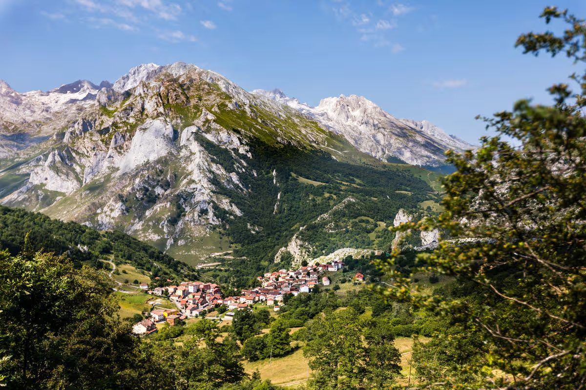
Time Out has ranked the 51 most beautiful places in the world, and the top spot goes to Spain’s Picos de Europa mountain range that’s just a two-hour flight from the UK with Ryanair
The Picos de Europa is in Spain and located just over 12 miles from the coastline(Image: Manuel ROMARIS via Getty Images)
The world is brimming with extraordinary destinations to discover, and pinpointing the most stunning is no easy feat, but Time Out has tackled the task.
The publication recently unveiled a list of the 51 most beautiful places in the world, featuring everything from lakes to beaches, National Parks, libraries, vineyards, and historic towns. Yet, claiming the number one position is a breathtaking mountain range that provides remarkable hiking opportunities, and it’s merely a two-hour flight from the UK.
The Picos de Europa in Spain is a striking, rugged limestone mountain range that soars to a height of 2,650 metres. Located just over 12 miles from the coastline, the mountains ascend steeply, forming deep gorges to discover, reports Express.
One route, the Cares Trail, ranks among the most sought-after walks in Spain, tracing a canyon and passing through craggy peaks and cascading waterfalls.
Spanning 13 miles in total, it’s not suitable for novices, though its gentle inclines make it achievable for walkers who can manage the distance. A straightforward choice is to board the Fuente Dé cable car, whisking you up the mountainside in moments and letting you relax and admire the verdant landscape below.
Upon reaching the summit, you can also explore additional hiking trails, including some demanding, steep climbs that provide spectacular vistas.
The mountains form part of the broader Picos de Europa National Park, and this region features the Lakes of Covadonga. These glistening blue waters are encircled by peaks and vegetation and resemble landscapes you’d encounter in Scotland or the Lake District, making it difficult to believe you’re in Spain.
This protected national park is abundant with wildlife, including brown bears, wolves, vultures, and eagles, and you’ll probably encounter mountain goats and vibrant butterflies amongst the limestone surroundings.
At the foot of the mountains, you can discover towns like the medieval Potes, brimming with centuries-old stone and half-timbered buildings and cobbled streets that lend it a rustic allure.
The town’s centrepiece is the Torre del Infantado, a 15th-century tower once the residence of medieval royalty, now a museum with a rooftop terrace providing sweeping views of the town.
Arenas de Cabrales on the park’s periphery is another favoured spot to stay. It’s renowned for producing Cabrales cheese, and has evolved into a gastronomic hotspot due to its plethora of acclaimed restaurants serving Northern Spanish cuisine.
Don’t expect to find paella on the menu. In this region, the dishes are hearty and rustic, such as bean stews and grilled meat, with ingredients sourced locally from the mountains.
The Picos de Europa is just under two hours from Santander Airport, and is serviced by airlines including Ryanair. Routes from the UK to Santander operate year-round from Edinburgh and London-Stansted, and seasonal flights operate from Birmingham and Manchester. Flights start from just £15 one-way and take 2 hours from the UK.
Got a story you’d like to share? Drop us an email at webtravel@reachplc.com
Standing in Tintern Abbey, you can feel the magic that has given this small Monmouthshire village on the banks of the Wye and its famous ruin such an outsized place in culture. JMW Turner, Gainsborough and Samuel Palmer are just some of the artists who have captured this landscape, and Wordsworth and Tennyson famously wrote poems inspired by Tintern. But it was Allen Ginsberg’s Welsh Visitation and his “clouds passing through skeleton arches” that came to mind while I sheltered from a cloudburst in the abbey’s nave. It’s a vast and fascinating site, and seeing it through sheets of rain as the sun went down was really special.
Ginsberg was here in the 1960s, following in the footsteps of the Romantics. But Tintern’s fame came thanks to its inclusion in travel writer William Gilpin’s 1782 book Observations on the River Wye. Gilpin’s writing about the “picturesque” – landscapes that inspired art through their rugged beauty – was so popular in the late 18th century that the Wye Tour was created to meet tourist demand, one of the first package trips in British travel history.
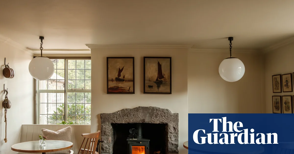
Tintern has been a destination ever since for literary travellers – though there are also many hillwalkers and canoeists who love the geography as much as the aesthetics of the area. So it’s interesting that the Royal George, the beautifully renovated coaching inn that has recently reopened in the village after a two-year refurbishment, takes local history and craft as its inspiration rather than leaning into the area’s national reputation.
The atmospheric ruins of Tintern Abbey. Photograph: Sebastian Wasek/Alamy
A building has stood on the hotel’s location since the 16th century – it was originally the village forge owner’s home – but the renovation has opened under the name the Royal George because that’s what local people have always called it. The name comes from the warship HMS Royal George, which sank in Portsmouth in 1782, drowning hundreds on board in one of Britain’s worst maritime disasters. Timbers salvaged from the wreck were supposedly used in the construction of the inn, which opened in 1829. Camilla Kelly, the designer behind the refurbishment, found a ship’s bell which bears the insignia of another George, this one HRH George VI, which is now used to call last orders in the hotel bar
There are exposed paving flags and beams that date back to the 1600s as well as charmingly wonky walls and low ceiling beams but, unlike many hotels that aspire to the rustic, shabby chic vibe currently popular for a country stay, the Royal George is smart and very well put together. In its 20 bedrooms and dining rooms there is some vintage furniture – Kelly grew up in nearby Abergavenny with parents who worked in antiques shops and markets – but it’s the beautiful blankets and textiles made at the celebrated Pembrokeshire Melin Tregwynt mill, the metalwork art by local blacksmith and sculptor Mark Lumley, and the ornaments from Baileys Home, a destination shop for interiors fans that’s just up the road in Bridstow, that define this place.
One of 20 rooms at the Royal George. Photograph: Dave Watts
It’s clearly a formula that’s proving popular with local people as well as visitors. At dinner time in the nautically named Upper Deck restaurant, there were families from the surrounding area who had come for a celebration meal. The pub dining room – the Lower Deck, of course – was full of local people including young parents sharing a plate of chips with their kids, as well as out-of-towners. It’s a testament to the quality of the food, which is really, really good.
Most dishes use ingredients from local farmers, growers and foragers and there are excellent and imaginative vegetarian options. Sunday lunch during my stay included a magnificent brie parcel as a special. Apparently, a local cheesemaker had brought in a particularly nice sample and chef Gareth Hope couldn’t resist adding it to the menu. I’d also recommend trying the Welsh wines – especially the sparkling Velfrey and the White Castle pinot noir.
Hope is particularly grateful that the George has become a pub for local people. At Christmas time, one of those dreaded courier delivery photos flashed up on his phone, of a parcel dropped in an unrecognisable doorway. Unfortunately, this parcel contained £450 worth of caviar for the Christmas menu. Hope shared his misfortune with the bar’s regulars and, after seeing the photo, one of them jogged off into a storm, reappearing with the caviar 20 minutes later.
It’s probably worth noting, with all this talk of fine food and furniture, that the Royal George isn’t as expensive as it sounds, with mains in the Lower Deck starting at £14 and a night in a garden room from £135.
The village of Tintern sits on the banks of the River Wye. Photograph: Maciej Olszewski/Alamy
If you want to walk off some of this lovely food, the 5-mile Angidy trail is an interesting journey through Tintern’s often overlooked industrial history. Before the abbey ruins turned it into a tourist attraction, the village was famous for its iron wire, and in 1600 the wireworks here were the largest industrial enterprise in Wales. The remains of the furnaces, waterwheels and workers’ cottages are dotted along the Angidy valley and among the hazel trees and larches on the forested hills. The ruins of St Mary’s church – built in the 13th century by the Cistercian monks for their lay tenants, but on a religious site dating back to the 5th century – will never rival the abbey, but the tombstones of the old industrialists – including one shaped like a wine cooler – are impressive, and there is a great view from the graveyard down to the Wye.
For a different but equally pleasurable excursion, go to the previously mentioned Baileys Home. The homeware store, owned by designers Mark and Sally Bailey, is massive. The showrooms fill not just a barn but also a cowshed, stable, granary and loft with a mix of antiques, vintage pieces and handmade furniture. You can browse smithy-made coat hooks and soap made from organic sheep’s milk for under a tenner, or try the bespoke sofas for size.
Inside or out, this is a very special corner of Wales. It may have found fame as a muse for visiting artists, but if you come here, don’t forget to look for the other stories told by the landscape.
Accommodation and dinner was provided by the Royal George in Tintern, which has doubles from £135, room only
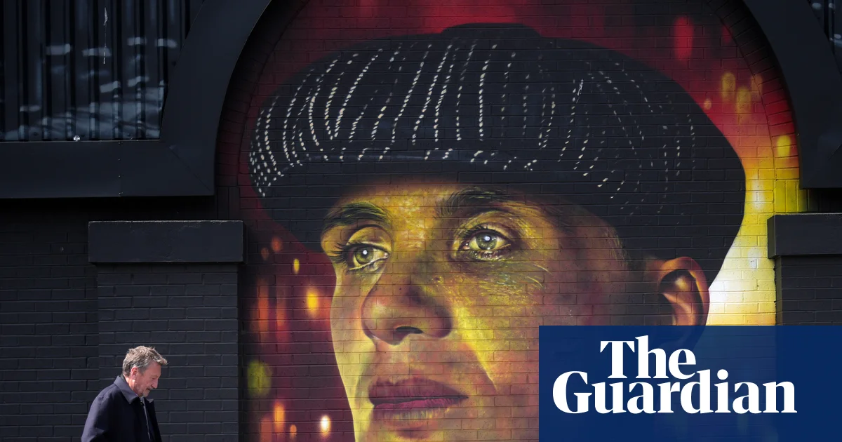
The runaway success of the TV crime drama Peaky Blinders has been credited with boosting tourism to Birmingham and the West Midlands since it first aired in 2013, even though much of the series was actually shot farther north, in Merseyside, Yorkshire and Manchester. The release this week of the Peaky Blinders movie The Immortal Man (much of which was filmed in and around Birmingham this time) will undoubtedly generate a new wave of interest, particularly in the Black Country Living Museum in nearby Dudley, whose authentic recreations of streets, houses and industrial workshops appear in key scenes in the TV show and the film – most notably as the location for Charlie Strong’s yard (pictured below).
The canal and blacksmith’s forge at Black Country Living Museum in Dudley. Photograph: Nathaniel Noir/Alamy
At the Digbeth Loc. Studios, where much of the new movie was shot, fans can also see Peaky Blinders murals created by artist Mr Murals. A walking tour of the city with a guide dressed as “Edward Shelby” (from £20pp, viator.com) is well worth a couple of hours, while historic mugshots, artefacts and the original cells in which members of the real-life Peaky Blinders gang were once held are now on show at West Midlands Police Museum.
The city has also become something of a pilgrimage site for heavy metal fans, especially since the final Black Sabbath concert at Villa Park last summer and Ozzy Osbourne’s passing just over two weeks later. There are Ozzy and Sabbath landmarks all around the city, including another of Mr Murals’ artworks on Navigation Street, near New Street station, which all four members of the band visited and signed ahead of the concert. A couple of minutes’ walk away is The Crown pub (now sadly closed) where Sabbath played their first gig and heavy metal was born out of Brum’s industrial clank. Sabbath also feature on murals outside Scruffy Murphy’s rock pub and beside Birmingham coach station in Digbeth – and no pilgrimage would be complete without a visit to Black Sabbath Bridge on Broad Street, where Ozzy’s widow, Sharon, and children Aimee, Kelly and Jack laid flowers during his funeral procession.
The Black Sabbath mural on Navigation Street, created by Mr Murals. Photograph: Jack Pro/Alamy
Birmingham’s metal connection doesn’t end there – the Jewellery Quarter is a pilgrimage site of a different type, mainly for couples looking for wedding bands. It’s said to house Europe’s largest concentration of jewellers and produce 40% of the UK’s jewellery; the FA Cup was even produced there. The quarter also boasts quirky attractions such as the Pen Museum (Birmingham once produced 75% of the world’s pen nibs) and the UK’s last coffin furniture factory, The Coffin Works, now a museum, whose long history includes decorative coffin fittings for the funerals of Diana, Princess of Wales, and the queen mother, among many others.
Where to eat – from fried chicken to fine dining
Attention to detail at Opheem, Birmingham’s two-star Michelin restaurant. Photograph: Carl Woods
In the city centre, John Bright Street is a great place to start – brunch at kitsch indie cafe-bar Cherry Reds is a good shout, while cider and speciality sourdough pizza spot The Stable remains underrated. Save some room for grungy, rock-themed fried chicken joint Bonehead, on the adjacent Lower Severn Street – a hangout for the Osbournes, Slipknot, Jason Momoa and Mogwai in recent times. In the Jewellery Quarter, the Saint Paul’s Market food hall has seven indie kitchens, including Persian, Indian, Thai and more.
Birmingham is also a city of fine dining – in 2019, Opheem became the first Indian restaurant outside London to be awarded a Michelin star; it now has two. Meanwhile, the Jewellery Quarter’s inherently alternative, goth-black restaurant (housed within a former factory, of course) The Wilderness has just won its first Michelin star, taking the city’s total to five. Chef-owner Alex Claridge cooks modern British fare using seasonal ingredients, such as rhubarb and rocket, that probably shouldn’t sit on the same plate, but pair surprisingly well. His menus are designed to surprise and provoke the senses – as is the heavy rock playlist.
Where to drink – from a pint of mild to craft beers
The Craven Arms, a pub serving traditional ales, in central Birmingham. Photograph: John Green/Alamy
It feels like every family in Birmingham once had someone working at one of its famous breweries, Mitchells & Butlers or Ansells. It’s therefore no surprise that pub culture remains very much alive in a city that birthed one of the region’s classic pints: M&B mild. Traditional pubs serving similar ales from around Birmingham and the West Midlands pepper the city – try Black Country Ales’ pubs The Craven Arms, The Jewellers Arms and The Wellington for starters. And don’t forget to order a cheese and onion cob to go with your pint for the full West Midlands experience.
The modern craft beer revolution is also very much alive in the city, with Attic Brew Co.’s Intuition most definitely the most poured craft pint in Brum (cans are also stocked on CrossCountry trains). Sample their wares at their central taproom, The Barrel Store.
Nightlife – from Irish boozers to experimental music
Suki10c nightclub in Digbeth, Birmingham. Photograph: Nick Maslen/Alamy
Much of Birmingham’s best nightlife can be found in Digbeth, the city’s original Irish quarter (where the Peaky Blinders also once roamed). Pubs such as Nortons, The Old Crown, Cleary’s and The Anchor offer some of the best Guinness, trad music sessions and craic this side of the Irish Sea. Digbeth is also the city’s creative quarter, and home to experimental concert promoter Capsule, which brings equal parts peculiar and brilliant musicians to Brum, who might otherwise skip the region completely. Keep an eye out for Capsule’s Supersonic festival, an award-winning event running since 2003 and scheduled for 25-26 April this year, that takes over venues in Digbeth. One such is Centrala, an experimental arts centre and exhibition space that supports central and eastern European migrant communities.
After hours, dance to northern soul at The Night Owl, or head to venues such as Dead Wax, Suki10c, Lab11 and Mama Roux’s for parties ranging in genre from house to jungle.
Stirchley – the hispter hotspot for cocktails and breweries
A 10-minute train ride south of New Street station is Stirchley, a neighbourhood of award-winning indies that continues to thrive. Take Couch, for example, just named the UK’s number one at the 2026 Top 50 Cocktail Bars awards, and South African-British fusion restaurant Riverine Rabbit, which was recently awarded a Bib Gourmand by Michelin.
Stirchley is also known locally as the beer hub of the city, with three major brewers (Attic, Birmingham Brewing Company and GlassHouse) within a half-mile radius; all three have taprooms. In keeping with Birmingham’s liking for a pint or few, the Stirchley Beer Mile takes in those three plus two award-winning bottle shops and at least 10 pubs and bars on an easy walk between Stirchley and Cotteridge. Don’t miss Bonehead’s dive bar Deadbeat, a similarly grungy rock bar that sells Pabst Blue Ribbon on tap and often hosts NYC-style pizza slice pop-ups.
Where to stay – Georgian hotels and modern townhouses
Boutique hotel Saint Pauls House in the Jewellery Quarter (doubles from £99) sits on the city’s last remaining Georgian square and offers comfortable rooms, waterfall showers and plush beds. Or stay around the corner at the modern Frederick Street Townhouse (doubles from £99), which is connected to the popular Button Factory pub.