IT’S THE end of an era as after 90 years, Coventry Airport is closing its runway for good today.
What originally opened back in 1936 as Baginton Aerodrome – and later served as a World War II RAF fighter base – has officially grounded all flights, leaving fans of the airport saddened.
Sign up for the Travel newsletter
Thank you!
Coventry Airport is closing for good todayCredit: Alamy
One fan of the airport commented online: “This was the best airport to fly from.”
Plans for the site have already been revealed, with it being transformed into a multi-billion-pound energy plant – though, several fans of the airport are not happy about the decision.
One person said on Facebook: “Such a shame an airport that has been there before World War II to be got rid of – just because someone wants to sell it for greed!”
Another added: “Sad to see the airport closing down; the airshows there were great and I had some happy times at the airport.”
Over the years the airport has seen its fair share of celebs including royalty Princess Anne and rock heroes Status Quo.
Airshows at the airport have hosted flying legends too such as the Red Arrows and Concorde.
Sun Travel takes a look back at the airport’s history.
1930s
The airport first opened back in the 1930sCredit: Getty
The airport officially opened in 1936, with a single grass runway.
In the late 1930s, the airport then looked to expand with Armstrong Whitworth Aircraft opening a factory next to the airfield.
This factory then later contributed to the industrial war effort.
1940s
During the war years, the British Royal Air Force used the airport as a base and fighter station.
Squadrons at the base included the Polish Fighter Squadron flying Hawker Hurricanes, the Royal Canadian Air Force and the Royal Australian Air Force.
However, the airport did become damaged in 1940 due to heavy bombing during the Coventry Blitz air raids by the German Luftwaffe.
Through the rest of the war, the airport was used to test bomber planes.
Commercial flights later started in the 1950sCredit: Getty
1950s
Commercial flights first took off from Coventry Airport in the 1950s with services from the Midlands to the Channel Islands.
1960s
During the 1960s, the airport began glider flights.
British United Airways also began flying from the airport – which was later merged with Caledonian Airways to form British Caledonian, which was then eventually absorbed into British Airways in 1988.
Aviation Traders Carvairs and Handley Page Dart Heralds also flew from the airport in the 60s.
1970s
Flights from the airport used to go to European destinations such as Italy and SpainCredit: Getty
Several open days were held at the airport in the 70s with historic aircraft being shown including a Bücker Jungmeister and a Messerschmitt 108.
Next to the airfield, The Midland Air Museum opened in 1978 with just five aircraft.
Despite the airport redevelopment, the museum will remain open with regular events and restorations.
Today the museum is home to more than 45 aircraft, including a Cold War nuclear bomber and Soviet helicopters.
Visitors heading to the museum can head on cockpit tours, watch aircraft be restored and enjoy a drink and light bites in the tea room.
1980s
The Pope even visit the airport in 1982Credit: GettyThe Pope toured the airfield, where there was a crowd of 350,000 peopleCredit: Getty
Coventry Airport was one of the first airports to gain a papal visit, with Pope John Paul II flying to the airport in a gold and blue helicopter in 1982.
He then toured the airfield, where he was greeted by a crowd of 350,000 people.
A company called Hards Travel also launched flights to Spain, France and Italy in the 1980s.
1990s
During the 90s, the airport became a 24-hour freight hub for Parcelforce.
More airshows were also hosted at the airport, with many locals able to take helicopter rides over the Warwickshire countryside.
2000s
Wizz Air launched flights from the airport in 2007Credit: Alamy
In the early 2000s, TUI AG launched low-cost airline Thomsonfly at the airport, basing its Boeing 737 planes there with flights to Europe.
Later, Wizz Air began flights from the airport in 2007 to Polish cities including Gdansk and Katowice.
However, these were short lived with the last passenger flight taking off in 2008.
By 2009, the airport had entered administration – though this too was short lived, with billionaire Sir Peter Rigby purchasing the airport in 2010.
Rigby reopened the airport with flight training schools, business jets, cargo and the West Midlands Air Ambulance.
Today
The airport will now be turned into a multi-billion-pound energy plantCredit: Alamy
Between 2021 and 2022, the local government approved plans to build the West Midlands Gigafactory, also known as Greenpower Park.
And in December 2025, the Civil Aviation Authority announced the airport’s official closure.
In May of this year, all flights were stopped with the flight schools and private jet owners told to move out of the airport.
In a final hurrah, Take That touch down at the airport for a concert in Coventry on June 5 as the last ever commercial flight at the airport.
You can’t own the beach in California. Our shoreline is public — thanks to the Coastal Act and the Coastal Commission — even when everything around it gets expensive and complicated. You can live next to it, monetize it and build a personality around proximity to it, but the wet sand itself belongs to everyone.
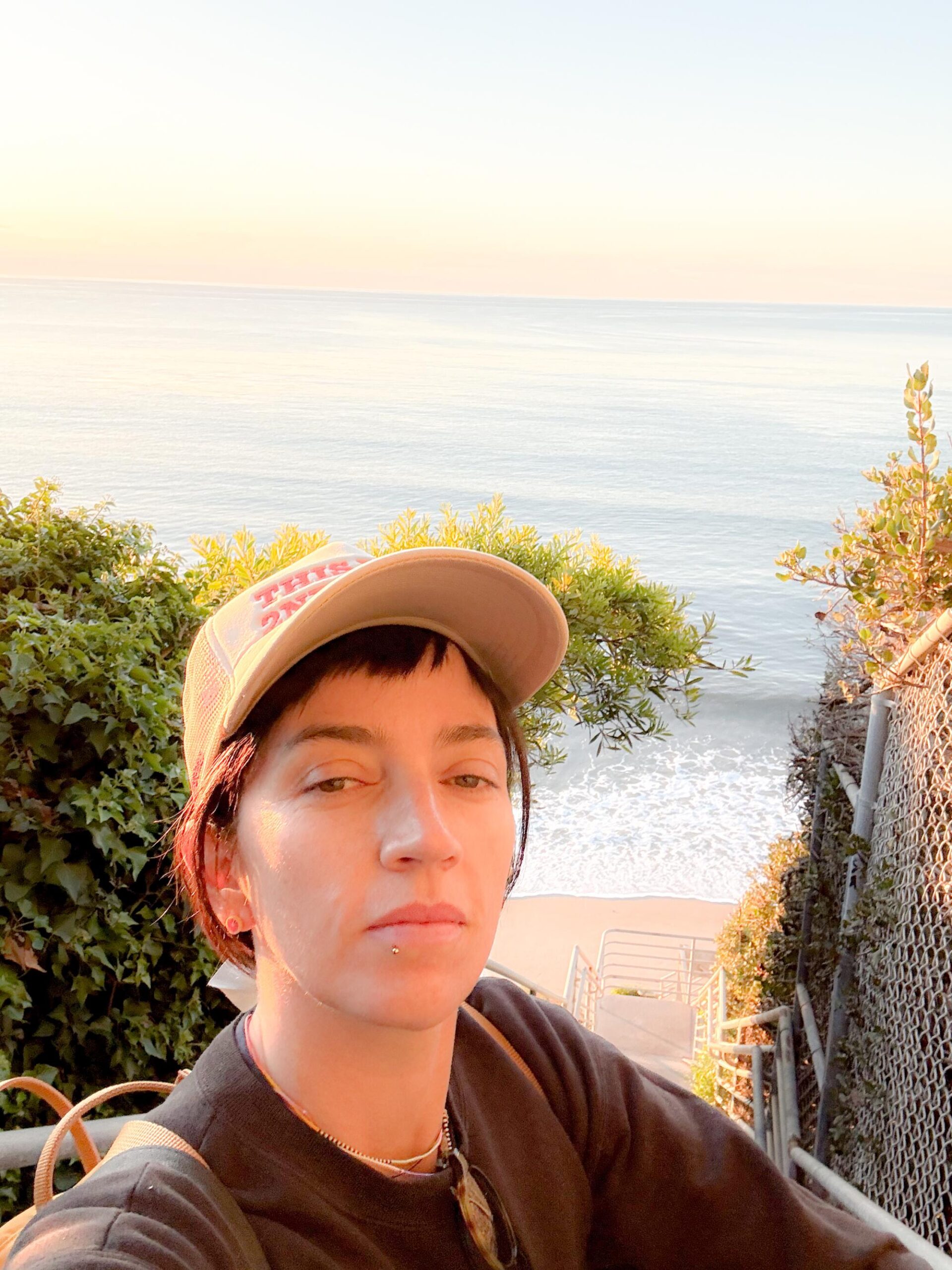
Jackie Snow takes a selfie by the new public stairs at Escondido Beach, also known as Hidden Beach.
(Jackie Snow)
In 2024, my colleague Jaclyn Cosgrove walked 27.4 miles of Washington Boulevard in a single day, from Whittier to the ocean. I read it in awe of the shape of it. One street. One day. A city revealed in a straight line.
And then a thought occurred to me, I could do something like that. What if I walked the entire L.A. shoreline? What would happen if I went to the beach and just kept walking along the crest of its waves? Except the shore does not reward this approach. It closes. It opens. Erosion pushes you onto the road and lets you back when it feels like it.
I set out to walk the 75 miles along the Los Angeles coastline anyway. I started at the mouth of the San Gabriel River and worked north toward the Ventura County line, taking 10 trips from the end of November to the second week of January, mostly waiting on tides and weather to cooperate.
Being a surfer helped. I already knew that wet sand means public access in California, that satellite view tells you things the default map doesn’t, and that tides can make or break an outing. For someone wanting to do a similar journey, the California Coastal Trail website is a valuable resource. You can walk long stretches and return back, but I went point to point, which means figuring out how to get back to your car. I usually Ubered, although public transit exists on some stretches. The slickest option is going with a friend who has a car: leave their car at the end, drive yours to the start, and walk. Their car is waiting at the finish to bring you both back to yours. Beyond that, bring more water than you think you need to especially as most stretches have no fountains, no services and no shade. Pack snacks that will sustain you throughout the journey, wear a hat and put on sunscreen, then reapply it. Even on gray, marine-layer days, you’re exposed for hours with nothing overhead.
If you’re inspired by this mega-trek but want to instead do a micro version, I suggest the 5.7 miles from Malibu Pier to Escondido Beach. You can park at one end and take a picturesque bus back where a tasty lunch at the pier’s Malibu Farm awaits at the finish. One last tip I picked up: be nice. People sometimes will give you water, or offer help, wanting to see you get to your destination too.
1
2
3
1.A red-tailed hawk perched on a coastal access sign along the boardwalk in Long Beach.2.A bench off the Long Beach boardwalk, near the start of the 75-mile walk.3.Birdhouses located near the Long Beach boardwalk.(Jackie Snow)
Alamitos Beach to Port of Long Beach: 4.9 miles
I start at the mouth of the San Gabriel River at Alamitos Park at about 10 a.m. on a busy Sunday at the end of November, walking with a friend. The first stretch is a flat, easy boardwalk. We stop at the Long Beach Museum of Art, which sits on the bluffs overlooking the water, and grab lunch at Claire’s, the museum’s outdoor cafe. From there, we walk toward the mouth of the Los Angeles River, passing through the marina, where boats sit quietly and a pirate ship is inexplicably for sale. We don’t make it up the man-made pier to the Queen Mary. Instead, we turn around just short of it, one river book-ending the other.
Looking back toward the marina near the mouth of the Los Angeles River, one river bookending the other.
(Jackie Snow)
Cabrillo Beach to Portuguese Bend Beach Club: 8.7 miles
I park at Cabrillo Beach, along the Port of Los Angeles, around 6:30 a.m. People are already playing ping-pong. Someone is dancing alone on the sand.
I start along the Cabrillo Beach Walking Path, which you enter at the south end of the beach where the sand ends and the bluffs start. In what feels like two seconds, I’m up on the cliffs, which quits partway and dumps me onto the residential streets of Coastal San Pedro, a neighborhood that looks quintessentially California. The houses are probably a few million dollars each, but they’re tidy bungalows, not the kind of aggressive beachfront wealth that makes you feel like you’ve wandered somewhere you’re not supposed to be.
I pass through Point Fermin Park, home to a lighthouse perched above the water. Down below, the beaches are rocky and loud. The waves are being sucked forcefully back out between the rocks, a sound that feels more industrial than oceanic. There’s more neighborhood walking on West Paseo Del Mar, interrupted by a Little Free Library stop where I add a few books to my bag. I hit the San Pedro hike trails, and the coastline turns dramatic, and suddenly I can’t step two feet off the path without risking a fall, but it’s breathtaking in its beauty.
Cabrillo Beach at the Port of Los Angeles, where the second walk began.
(Jackie Snow)
I hit another closed section, this one bordering Trump National Golf Club in Rancho Palos Verdes. Not wanting to end up on a Secret Service list that bars me from flying, I find another way around, on a surprising trail that curves between holes that’s part of the Ocean Trails Reserve. I climb down to the beach and start picking my way along the rocks toward the Portuguese Bend Beach Club, moving slowly and trying not to break my neck. You can definitely skip this part.
A security guard named Gilbert Blair waves me over and explains to me what I already know: I’m allowed to walk on the wet sand, but everything else is private. When I tell him what I’m doing, he starts offering advice, pointing out places on my Google map he thinks are closed because of last year’s heavy rains. This area is some of the shiftiest parts of all of California, with landslides going back all through the geographical record. In 2024, areas were moving 9 to 12 inches a week, although it has slowed down to 1 to 2 inches a week. He tells me the unstable land actually created a new beach, which the coast almost never does. People came from all over to see it, he says, gesturing toward a new form of sand that locals have called “unreal.”
Blair is nice, but not nice enough to wave me off the wet sand and through Portuguese Bend’s private roads so I can call an Uber. I have to backtrack, spending more time than I’d like carefully navigating the rocks. I briefly consider stopping at the nearby Trump National Golf Club to eat and use the bathroom, but I’m hot, sweaty and not in the mood to test my welcome.
The trail descending toward the rocky beaches below Point Fermin, where waves get sucked back out between the rocks with a sound more industrial than oceanic.
(Jackie Snow)
Terranea Beach to Palos Verdes Estates Shoreline Preserve: 5.4 miles
Based on Blair’s advice, I skip a section that isn’t open to the public and probably not safe. I drive Palos Verdes Drive South, a rutted, uneven road that skirts the area and feels vaguely off-roading. I park at Terranea Resort, which charges a fee, but there is also nearby free public parking. I pick the walk back up at the charming tucked-away Terranea Beach. As I head north, the trail climbs. I can see stretches of shoreline closed off, tantalizingly visible with no way to reach them.
I stop at the Point Vicente Interpretive Center, a modest but free museum perched above the water. Several people are gathered outside with binoculars, scanning the horizon. They tell me humpbacks were spotted farther out earlier, feeding. It’s easier to see them on the far side of Catalina, they explain, but they still watch from here, every day, sunrise to sunset, December through May. This is the Gray Whale Census and Behavior Project, run by the American Cetacean Society. Volunteers have been coming here for 43 years, counting whales as they migrate past the point.
The Point Vicente lighthouse, perched above the water where Gray Whale Census volunteers keep watch.
(Jackie Snow)
Volunteers with the Gray Whale Census and Behavior Project scanning the horizon. They’ve been counting whales here for 43 years.
(Jackie Snow)
After I peel myself away from looking for whales, the tides won’t allow me to climb down to Honeymoon Cove. I stay on the cliffs and admire the impressive houses around me. I continue until I round the Palos Verdes Estates cliffs, on Paseo del Mar, and see the long, flat stretch of built-up beaches unfurling ahead, South Bay-style, Malibu faint in the distance.
I’ve only done about 15 miles of my walk and suddenly I see how much more there is to go. I’m hot. I’m tired. I packed bad snacks. The sheer expanse of it, frankly, stresses me out. I had planned to make it to Rat Beach in Palos Verdes Estates, but I call it early.
The small coves that punctuate the Palos Verdes coastline, visible from the cliffs above.
(Jackie Snow)
Palos Verdes Estates Shoreline Preserve to El Porto Beach: 7.9 miles
I start back at Palos Verdes Estates cliffs. A couple of turns in, I come across my first real surf spot of the walk. I don’t think I’ve ever seen a surf break from this high up. The waves look less like waves and more like pulses of energy moving under the skin of the ocean.
When I finally hit Rat Beach and see how flat the coastline stretches ahead, I feel like dropping to my knees and kissing the ground. After days of cliffs and detours, the openness feels generous.
Hermosa Beach is busy with volleyball nets in use at a level that suggests Olympic aspirations. Forty minutes later, I stop atErcole’s in Manhattan Beach two blocks off the boardwalk and demolish one of its famed burgers. Instead of stopping where I planned, I keep going and end at my familiar surf spot El Porto.
Surfers walking out to the break at El Porto.
(Jackie Snow)
El Porto Beach to Ballona Creek Jetty: 4.8 miles
I’m back at El Porto Beach, this time walking a paved boardwalk through a thick, foggy marine layer with my husband and a friend who’s in town visiting.
Suddenly, my friend realizes he’s dropped his wallet somewhere north of El Segundo. Cue a round of retraced steps and mild panic. An angel named Dr. Gaz finds it, looks up my friend, and bikes it over so we don’t have to retrace any further. The wallet is returned. Our trio survives. We keep walking, stopping at Ballona Creek Jetty.
A dog and his man relaxing on the beach in Marina Del Rey.
(Jackie Snow)
Marina Del Rey to Will Rogers Beach: 7.4 miles
In this classic boardwalk stretch, we eye the muscle men of Muscle Beach, pause for a quiet break atSmall World Books in Venice and walk next to skateboarders (including one dressed as a Santa) in Santa Monica, before ending at Will Rogers State Beach.
The rocks and tide pools just past Malibu Lagoon, where the king tide pulled the water back farther than usual.
(Jackie Snow)
Will Rogers Beach to Malibu Pier: 7.7 miles
I do this stretch with my husband on New Year’s Day, parking at Will Rogers Beach Lot Three and timing it to a king tide. The highs are higher, but the lows are lower too, which is the part we’re interested in.
Even with the king tide low, the beach opens up and pinches closed without warning, and we move between wet sand, rocks we feel like traversing, and the shoulder of the Pacific Coast Highway when we don’t.
Soon enough, we hit the section of burned-out houses that still haunt the beach nearly a year later. I think I can still smell the smoke. It’s the quietest stretch of the whole walk, and the only place the emptiness feels like loss instead of calm.
The Malibu coastline near Escondido Beach.
(Jackie Snow)
When we finally reach the Malibu Pier, it feels like stepping back into civilization. People are on the beach. Nobu is packed. We eat at Malibu Farm and sit indoors, grateful for chairs, shade and food that isn’t trail mix.
Afterward, we take the bus back to the car from a stop near the Pier on the PCH, which turns out to be one of the most beautiful bus rides in existence, with the coastline framed perfectly by wide windows.
Malibu Pier to Escondido Beach: 5.7 miles
We come back the next day for another king tide, despite rain in the forecast. I start on the other side of Malibu Lagoon State Beach, which looks like nothing else on this walk. It’s swampy and green and quietly buzzing, reminding me of Florida, my home turf. Birders are out, rain jackets zipped, binoculars already up.
There are still rocks and little rivers to navigate, but the tide is so low it’s exposing tide pools I didn’t know existed up here. The sand is packed and forgiving, and we cover distance quickly until the rain really starts coming down.
We exit using the new stairs at Escondido Beach, also known as Hidden Beach, which were installed in 2023 after a multidecade battle over access. I take them slowly as I celebrate a mostly triumphant walk.
The Malibu coastline just south of Point Dume.
(Jackie Snow)
Escondido Beach to Zuma Beach: 6.7 miles
I head back to Escondido Beach, a few days later at low tide, though the tide is already coming in. That turns out to be a mistake. My second mistake is coming alone. As I scramble over rocks helpfully labeled with a sign warning not to climb on them, it’s dangerous, I notice my phone has no service. I decide the safest option is to soak my hiking boots instead along the incoming tide.
With my shoes sloshing and Google Maps satellite view looking deeply uncommitted to the stretch just south of Point Dume, I try to exit. Nope. Gated community. Not ready to give up, I keep going.
The surfer south of Point Dume whose companions offered to unlock the gate.
(Jackie Snow)
I spot a woman surfing and stop to take a photo. Her non-surfing companions start chatting with me. When they hear what I’m doing and where I’m trying to go, they offer to unlock the gate. It’s a genuinely kind gesture. But since I’m doing this for you, reader, I ask if there’s an exit farther along. They say there are stairs up ahead, probably reachable. I tell them, in the nicest way possible, that I hope I don’t see them again, and keep going.
My shoes are now collecting water on every step, the bottoms of my pants are wet, and everything underfoot is baseball-sized rocks, which I think is the worst possible rock size for walking. I round the curve. I spot the stairs.
If I had turned off satellite view, the stairs would have been obvious. So much for trying to read the coastline.
I climb out and walk to the tip of Point Dume and look south. I can see the South Bay, where I called it early weeks ago, hot and tired and hating my snacks. I’m still hot. I’m still tired. My snacks are still crummy. But standing here, salty and damp, I realize I don’t want this to walk to end.
The view from the cliffs near Point Dume.
(Jackie Snow)
Zuma Beach to county line: 5.3 miles
Today I timed the hike with a tide going out and my husband joins me so I don’t have a repeat from last time. We park along the PCH at Zuma. The first stretch we go by “Hannah Montana’s View,” a very persistent Google map label. It’s calm until a curve, where a gaggle of adolescent boys, shirtless and shoeless, are trying but failing to climb over the mussel-covered rocks ahead of us. For the second time on this walk, I have to turn around and back-track to the last exit, maybe a quarter mile back.
Luckily, the sighting of a Little Free Library makes the detour feel less like a failure and more like a reward. We cut through a small gated community that turns out to have a door for exactly this purpose, a quiet acknowledgment that people do, in fact, want to walk through here. There is so much rock walking. So much. Eventually we reach Leo Carrillo State Beach, where Los Angeles actually ends and Ventura County begins. Despite the name, County Line Beach is another mile or so away.
Gated Lechuza Point neighborhood has a beach access road that lets walkers get to the shore.
(Jackie Snow)
I watch people walk across the county border without noticing it at all, no fanfare, no announcement, no sense that anything has changed. They keep going. I stop. They are not done walking, but I am.
I haven’t seen every inch of the Los Angeles County coastline. I double-checked my walking distance and I’m still not at 75 miles, more like 65. The number I found online is probably not entirely accurate (the coastline is constantly changing). Maybe it’s closer to 70. But I have seen whale-watch perches, burned-out Malibu lots, crowded boardwalks and magnificent waves. The coastline is both fragile and welcoming — and walkable — if you’re willing to chase the tides.
Grizz Chapman, an actor best known for his role as Grizz on NBC’s Emmy-winning comedy “30 Rock,” has died. He was 52.
Chapman’s cousin, Donte Harrison, confirmed the actor’s death on social media.
“Life gave my cousin Grizz Chapman some heavy battles, but he fought them with strength and dignity until the very end,” Harrison wrote. “A lot of people knew him as the sitcom star from 30 Rock, but we knew the man behind the screen. A good heart, good energy, and somebody who made an impact in this life.
“After years of fighting illness and dialysis, he passed peacefully in his sleep on May 22nd, 2026. I’m thankful we got time to reconnect 2 months before his passing.”
Born Mack D. Chapman on April 16, 1974, in Brooklyn, N.Y., Chapman got the name Grizz while working as a security guard at nightclubs around New York. The claim to fame of the 7-foot-tall security guard turned actor would be portraying a character that resembled himself: a towering bodyguard named Grizz.
Chapman played the mild-mannered bodyguard across 80 episodes of the wildly popular sitcom “30 Rock,” which starred Tina Fey, Tracy Morgan and Alec Baldwin. Chapman’s character was part of the entourage of Tracy Jordan (played by Morgan).
Chapman told Cracked in 2024 that landing “30 Rock” was the “hardest/easiest audition I ever had in my life.”
But it wasn’t until the second season of the show that Chapman felt he really broke through as a performer. On Episode 210, he performs a rendition of “Midnight Train to Georgia” alongside the veteran ensemble. “That showed so many levels of our talents — we got a chance to dance, we got a chance to sing, we got a chance to take direction and to be funny.”
In addition to acting in various projects, including the 2014 film “The Cobbler,” which starred Adam Sandler, and the 2016 thriller “Money Monster,” starring George Clooney and Julia Roberts, Chapman was an advocate for the National Kidney Foundation.
The actor battled high blood pressure and kidney disease and struggled with his weight for years, and in 2009, he announced he was seeking a donor for a kidney transplant. During an appearance on “The Dr. Oz Show,” the actor said, “I don’t want to go through this forever.”
Chapman told Dr. Oz that he’d coped with the news by acknowledging it was “a scary situation” but deciding to “face it one way or another.”
When Dr. Oz asked him what he wished for, the actor said, “I want to stay alive.”
Chapman spent nearly two years undergoing dialysis treatments three days a week for 4½ hours a day while filming “30 Rock” and hoping for a donor. In the process, he lost more than 150 pounds, hoping to be fit enough for the procedure. After the episode of “Dr. Oz” aired, a fan of Chapman’s, Ryan Perkins, flew from Arizona to New York to meet the actor. Perkins, then in his early 20s, knew he wanted to do something that could change someone’s life.
“I was emotional. I was excited. I wanted to scream. It was exciting to meet someone with that kind of willingness to help,” Chapman told the East Valley Tribune.
“How do you ever repay someone for something like that? You can’t. It’s not like borrowing $20 from someone and telling them you’re going to give it back. It’s something that you can never repay someone for.”