I see nothing but hills, ridges and sea: a breathtaking five-day walk around Ireland’s south-westernmost headland | Walking
The Sheep’s Head peninsula is clearly a good place to be a skylark. They seem to warble overhead at every turn, singing their little hearts out – and who could blame them? The hills here are high and heathery, the sea breeze is warmed by the Gulf Stream and the edge-of-the-world scenery is a realm of wild green slopes and endless blue Atlantic. If you had to choose a sky to lark in, the one that crowns this County Cork headland is a bona fide wing-quiverer.
The peninsula wows hikers, too. I’ve come to one of the south-westernmost points on the Irish mainland to trek the Sheep’s Head Way, a long-distance trail opened by the local community 30 years ago this summer. It took serious work to complete – more of which later – but it’s a delight. I’m walking the original 55-mile (88km) loop around the peninsula, although a longer, 63-mile option is now considered the official route. The way attracts a fraction of the numbers drawn to the Kerry Way and Dingle Peninsula trail further north, and thanks to its untrammelled paths and rampant, cliff-edged scenery, the rewards are grand, in every sense.
“Ah, you’ll love it,” enthuses Thérése Linehan of Doire Liath B&B in Bantry, having fuelled me with poached eggs and soda bread for breakfast. “People do.” This colour-splashed harbour town, at the landward end of the peninsula, is the route’s start and end point. I’m setting off on a Friday and the waterside square is busy with market stalls: fresh seafood, local artworks, turbo-strength flat whites. A statue of 18th-century revolutionary Wolfe Tone stares out to sea. I dawdle a while in the chilly May sunshine, then walk west.
The early miles wind up into the range of rounded drumlins that form the spine of the peninsula. Wildflowers speckle the gorse verges; boggy paths squelch underfoot. Soon, the views open up. Bantry Bay to the north, Dunmanus Bay to the south and a belt of shaggy-grassed peaks stretching out ahead. Swallows are cavorting in the wind. I turn and see nothing but hills, ridges and sea. Where is everyone?
Despite being almost at the westernmost limits of the European map, the region is no historical hinterland. Folklore holds that Bantry Bay was the place where feet were first planted on Irish soil, in 2680BC. Millennia later, in 1796, the same bay witnessed an attempted landing by a vast French fleet looking to help local resistance forces against English rule, only to be thwarted by storms. I’m luckier with the weather. Today the bay is sun-stippled and marble smooth.
The themes of this first day – near-empty trails, unbridled scenery, spring birdlife and heady history – set the tone for those that follow. The loop walk is traditionally split into five or six days – I’m doing it in five. For the first two, with crags and coastal meadows cascading around me, I pass only sheep. Cuckoos sound from woodland patches, stonechats flit between rocks, squadrons of hooded crows glide overhead. High, lonely stiles come in their dozens; abandoned 1840s stone homesteads stand sentry above the sea.
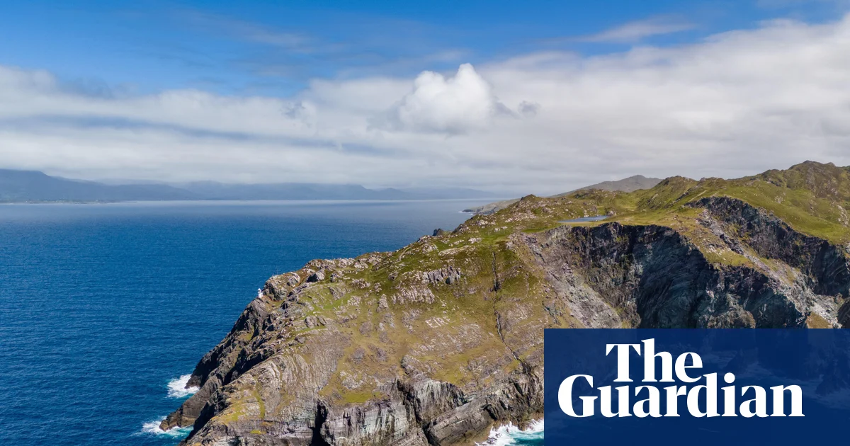
At one point the trail ascends to a 345m (1,130ft) viewpoint known as Finn McCool’s Seat, where the legendary giant is said to have sat and rested. I do the same, gazing at the peninsulas further north. I don’t know whether, like me, McCool was sapped enough to wolf down two packets of Taytos while he lingered.
There are few settlements on the first half of the anticlockwise route, so prearranged road transfers take me to and from Bantry to the trail on the first two days. The town has the advantage of myriad pubs and restaurants. Ma Murphys bar, 185 years old, does a fine drop of Murphy’s – which often outsells Guinness in these parts – and sets things up nicely for what is arguably the scenic climax (and far and away the busiest part) of the walk, a roller-coaster trek on Day 3 out to the lighthouse on the promontory’s furthest cliffs.
I reach it in early afternoon. The sea is huge and aglitter. Gannets patrol the waves. To the south, across Dunmanus Bay, is Mizen Head, traditionally the last finger of Irish land seen by people sailing to North America. The Sheep’s Head path now spins on its heel and heads east, past a wayside shrine and a tea-and-toasties cafe. Within half an hour the trail is deserted again, its yellow markers leading back into the tussocky green of the hills.
The trail is so well signed that it’s easy to overlook the complexity of shaping a hike around an entire peninsula. The Sheep’s Head Way has an office in the village of Kilcrohane, my base for that night, where I meet local farmer James O’Mahony. Now 82, he was one of the original mid-1990s founders of the trail, along with the late Tom Whitty, a Philadelphian who fell in love with the region. They envisaged a hike that would promote the peninsula’s charms to the full, benefiting not just walkers but local communities. Setting it up, however, required effort.
“There’s no crown land in Ireland, it’s all freehold,” explains James, speaking softly in a thick Cork accent. “We had 265 different landowners to speak to, all on the route. Some of the farmers couldn’t believe their land might appeal to hikers. They’d say, ‘Why would anyone want to walk my old hill?’” He chuckles. “One of the aims was also to keep our old pathways alive. Lots of them were funeral paths, mass paths, church paths. That was very important.”
The trail took 18 months to complete. While never overcrowded, it has won wide recognition, including a European Destination of Excellence Award in 2009 for “respecting its protected environment while meeting the needs of local residents and visitors”. All landowners on the route still receive an upkeep payment from the government’s rural affairs department, a committee of volunteers oversees the trail and a small, grant-funded team of workers is tasked with maintaining it.
The next day, I’m back on the trail. The 11-mile stretch from Kilcrohane to Durrus, my last staging post before a final day’s walk back to Bantry, is as all-enfolding as all that’s come before. There are historical gems – including a bronze age stone circle and the ruins of a bardic school that, by some local accounts, can claim to be one of Europe’s oldest universities – and more of those coastal views.
There’s a feeling you get when you complete a long-distance trail, a sweet fatigue that holds a sense of the miles walked. This is a special corner of a special county, and the trail that snakes its way around the peninsula – soggy in places, steep in others, but rarely less than spectacular – is one to be celebrated.
The trip was provided by Tourism Ireland and Ireland Walk Bike Hike, which offers seven-day Sheep’s Head Way sel-guided packages, with five days of hiking, B&B accommodation, transfers and luggage transfers from €885. Five-day packages also available. For more information on the Sheep’s Head Way, visit thesheepsheadway.com