‘Milestone’: Macron opens Paris monument honouring Rwanda genocide victims | Genocide News
Macron, who has acknowledged French ‘responsibility’ in the genocide, called the memorial a reconciliation ‘milestone’.
Published On 2 Jun 2026
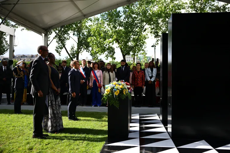
French President Emmanuel Macron has presented a memorial in Paris dedicated to the victims of the 1994 Rwandan genocide, as France pursues closer ties with the East African country and continues to grapple with its role in the historic atrocity.
Speaking at the inauguration event alongside his Rwandan counterpart Paul Kagame on Tuesday, Macron said the monument marked “the culmination of a long and patient quest for truth”.
Recommended Stories
list of 3 itemsend of list
“An unprecedented reconciliation has emerged between Rwanda and France,” said Macron. “This monument, while it is an achievement, is not an end. It is a milestone on a path we have opened.”
Dubbed “L’Archive” (The Archive), the monument consists of two black brass steles, and it bears an engraved tribute to the estimated 800,000 men, women and children, mostly ethnic Tutsis, massacred between April and July 1994.

The memorial’s inauguration comes five years after Macron travelled to Kigali and first acknowledged France’s failure to heed warnings of impending massacres in Rwanda.
Macron has said Paris and its Western and African allies did not have the will to halt the genocide, though he has stopped short of issuing a formal apology.
‘Requires real courage’
Speaking at the ceremony, Kagame hailed France’s efforts to assume its share of responsibility, and praised Macron for his “courage and humanity”.
“France was not alone in falling short, far from it,” said Kagame, who had long accused France of “complicity”.
“Many other countries did so as well, but none has gone as far as France in setting the record straight and accepting its part in the tragedy.
“Confronting historical responsibilities requires real courage because it generates a fierce opposition by those with a case to answer,” Kagame said.

When the genocide against the Tutsis occurred in 1994, France had been a long-standing backer of Rwanda’s Hutu-dominated government, leading to decades of tensions between the two countries, including a break in diplomatic ties between 2006 and 2009.
A commission set up by Macron and led by historian Vincent Duclert concluded in 2021 that France had been blinded by its colonial attitude to events leading up to the genocide and bore a “serious and overwhelming” responsibility for failing to foresee the slaughter.
However, it said there was no evidence that Paris was complicit in the killings.
‘Part of France’s public history’
Duclert said the unveiling of the monument was a “powerful” step. “The genocide against the Tutsi is now fully part of France’s public history,” he said.
The French courts, acting on the principle of universal jurisdiction to try the most serious crimes committed worldwide, have convicted several Rwandans for their part in the massacre.
In May, France’s judiciary ordered the resumption of an almost two-decade investigation into accusations that the widow of late Rwandan President Juvenal Habyarimana, who has lived in France since 1998, was involved in the genocide.