Floods

Search intensifies for missing children after deadly Texas floods | Floods News

A devastating flash flood has torn through Texas in the United States, killing dozens, including children, and leaving many others missing.

Search and rescue teams are working around the clock, deploying helicopters, boats, and drones to search for survivors, some stranded on trees and areas isolated by destroyed roads, and to recover victims’ bodies.

Camp Mystic, a Christian girls’ summer camp along a river in Kerr County, suffered the most damage, with more than two dozen campers still unaccounted for. The picturesque landscape, with its shallow rivers winding through hills and valleys, creates ideal conditions for deadly flash floods, making it one of the most flood-prone US regions.

In the early hours of July 4, 2025, floodwaters surged through an area about 112km (70 miles) west of San Antonio that houses summer camps and small communities. At least 50 people have been killed so far, while 27 girls from one camp are still missing.

The deluge began when heavy rainfall sent water rushing down hillsides into creeks, which then overwhelmed the Guadalupe River.

By Saturday, rescue personnel searched through a devastated landscape of twisted trees, overturned vehicles, and mud-covered debris in an increasingly urgent effort to find survivors. Authorities have not specified the total number of missing people beyond the children from Camp Mystic.

The powerful floodwaters rose 26 feet (8 metres) on the Guadalupe in just 45 minutes before dawn on Friday, sweeping away homes and vehicles. The rains continued on Saturday, with flash flood warnings and watches remaining in effect.

Source link

Texas floods death toll rises to 27 as rescuers search for missing children | Floods News

Authorities in US state face questions about whether they issued proper warnings in advance of rain-fuelled flooding.

Rescuers in the US state of Texas are scrambling to locate more than two dozen children still missing from a Christian summer camp after a powerful storm caused flash floods that authorities say have killed at least 27 people.

Kerr County Sheriff Larry Leitha told reporters on Saturday that the death toll included nine children.

Leitha said around 800 people had been evacuated from the region, about 137km (85 miles) northwest of San Antonio, as flood waters receded on Saturday morning.

Torrential downpour on Friday caused the fast-flowing Guadalupe River to rise nearly nine metres (29 feet) near the Camp Mystic summer camp, where around 750 children were staying.

Twenty-seven attendees were still unaccounted for, according to Dalton Rice, city manager of the nearby town of Kerrville in Kerr County.

The Heart O’ The Hills summer camp, located about 1.6km (1 mile) from Camp Mystic, confirmed on Saturday that its director, Jane Ragsdale, was among the dead.

While the National Weather Service (NWS) said the flash-flood emergency had largely ended for Kerr County – the epicentre of the flooding – it warned of more heavy rain to come, maintaining its flood watch until 7pm local time (00:00 GMT on Sunday).

Rice said that more than 1,000 rescuers were on the ground to help with search-and-rescue efforts. Helicopters and drones were being used, with some people being plucked from trees. US Coast Guard helicopters had flown in to assist.

“They are looking in every possible location,” said Rice, adding that search crews were facing harsh conditions while scouring waterlogged rivers, culverts and rocks.

Reunited family members after Texas flash flooding
People are reunited at a reunification centre in the town of Ingram after flash flooding hit Texas, on July 4, 2025 [Eric Gay/AP Photo]

Reporting from Washington, DC, Al Jazeera’s Heidi Zhou-Castro said that rescue workers had promised to “not give up until the very last person is found – either alive or their body is recovered”.

“That might be a tall order given just how catastrophic these floods were. We’re talking about a region that is dotted with hills and with canyons,” she said.

She added that children in the camps had been particularly vulnerable to the floodwaters, “which rose by eight metres [26 feet] in less than an hour, overnight as they slept”.

Authorities under scutiny

The flooding in the middle of the night on the Fourth of July holiday weekend caught many residents, campers and officials by surprise.

Authorities have come under increasing scrutiny over whether they issued proper warnings and whether enough preparations were made.

State emergency management officials had warned as late as Thursday that west and central Texas faced heavy rains and flash flood threats “over the next couple days”, citing NWS forecasts ahead of the holiday weekend.

The weather forecasts, however, “did not predict the amount of rain that we saw”, W Nim Kidd, director of the Texas Division of Emergency Management, said during a news conference on Friday night.

“A lot of questions are being asked about why there weren’t earlier evacuations,” said Al Jazeera’s Zhou-Castro. “They knew there might be rain, they just didn’t know where it would hit, and when it did, it indeed was catastrophic.”

On Saturday morning, US President Donald Trump said the federal government was working with state and local officials to respond to the flooding.

“Our Brave First Responders are on site doing what they do best,” Trump wrote on his Truth Social platform, adding that Secretary of Homeland Security Kristi Noem would soon be on the ground.

The weekend disaster echoes a catastrophic flood almost 40 years ago along the Guadalupe River, where a bus and a van leaving a church camp encountered floodwaters and 10 teenagers drowned trying to escape, according to a NWS summary of the 1987 storm.

Flash floods along Guadalupe River in San Angelo, Texas
A drone view shows flooded houses following torrential rains that unleashed flash floods along the Guadalupe River in San Angelo, Texas, June 4, 2025 [Patrick Keely via Reuters]

Source link

Beautiful ‘Venice of the North’ city is one of Europe’s most underrated cities

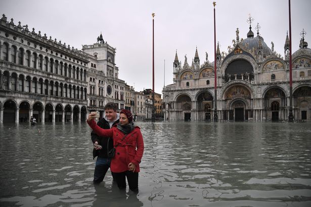
With thousands of tourists flocking to cities like Amsterdam and Venice, this beautiful city in Belgium, named the “Venice of the North” is one of Europe’s most underrated and is far less crowded

Scenic view from the belfry in Bruges, Belgium.
Bruges has cobblestone streets medieval architecture and stunning canals (Image: Deborah Lynn Guber via Getty Images)

While Amsterdam and Venice are flooded with tourists, a picturesque Belgian city known as the “Venice of the North” is one of Europe’s hidden gems, boasting fewer crowds and just as much charm. Situated on Belgium’s northwest coast, this enchanting city offers cobblestone streets, medieval architecture, canals and a rich history, making it an ideal destination for those seeking a more authentic experience.

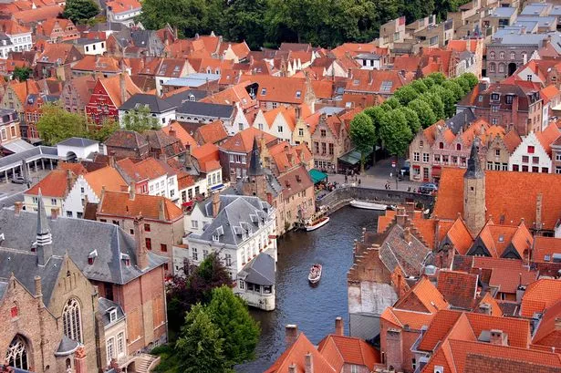
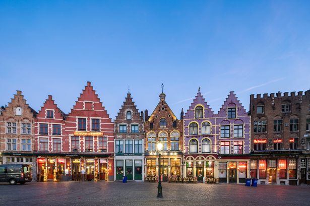
Only an hour’s train ride from Brussels, Bruges has preserved its quaint, romantic atmosphere, making it a top choice for tourists seeking a less crowded alternative. The city’s remarkably well-preserved medieval centre features towering buildings, rows of gabled houses, pointed arches, ornate facades, and barrel vaults seamlessly blending history with modern trends.

READ MORE: Boots’ new ‘by far the best’ range including gut powder that ‘really helps with bloating’

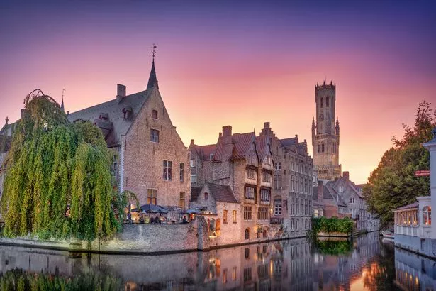
Bruges’ oldest buildings, showcasing early Romanesque and Gothic styles, are still standing, including the iconic 13th-century Belfry of Bruges bell tower. For a small fee, visitors can climb the 366 steps to the top for breathtaking views of the town and its surroundings, reports the Express.

Other must-see attractions include the Museum of the Church of Our Lady, home to the world’s second-tallest brick tower, and the Basilica of the Holy Blood, which houses a cloth believed to be stained with the blood of Jesus. Bruges, often likened to Venice, boasts a complex network of canals linking various parts of the city.

The majority of attractions are within walking distance, and those that aren’t can be reached via a picturesque canal ride. Initially used for transport and commerce, these canals now play a vital role in the city’s culture, offering a Venetian experience without the throngs of tourists.

Market Square in Bruges, Belgium.
The Market Square in Bruges(Image: Hongjie Han via Getty Images)

Another way to explore Bruges is by horse-drawn carriage. Setting off from one of the main squares, these carriages navigate the city’s winding cobbled streets, crossing ancient bridges and passing through other significant squares, all while the coachman provides commentary, according to Visit Bruges.

However, it’s worth noting that these rides do not operate when temperatures exceed 30°C to protect the horses’ welfare.

Bruges also serves as a cultural and artistic hub, housing numerous world-class museums such as the Groeningemuseum and the Memling Museum, which display Flemish and Dutch art, statues, and sculptures.

The city also celebrates contemporary art, hosting the Bruges Triennial every few years, where artists erect modern installations throughout the city.

Renowned for producing the finest chocolate globally, Bruges boasts some of the richest chocolate in the nation.

This charming city is home to numerous Belgian chocolate shops, where expert chocolatiers utilise premium ingredients like high-quality cocoa beans, cocoa butter, and fresh local dairy products to craft their exquisite chocolates, as noted by Fodor’s Travel.

Visitors can indulge in an array of flavours and fillings, including nuts, liqueurs, and fruits, and even explore the chocolate museum, Choco-Story Brugge, which offers a glimpse into the history of chocolate-making and hands-on workshops.

Photo of the bruges old town, Belgium. Taken on october 9, 2024.
Bruges has a beautiful old town(Image: Luís Henrique Boucault via Getty Images)

For a more substantial culinary experience, Bruges’ restaurants, nestled within the city’s historic buildings, serve a delightful blend of Belgian and French cuisine.

Be sure to try the crispy Belgian frites, or “pommes frites” which are often accompanied by an assortment of side sauces, including truffle mayonnaise, BBQ and Indian curry.

Flemish Stew is another local favourite. If you prefer to avoid the summer crowds and heat, Bruges hosts one of Europe’s most enchanting Christmas Markets, making it an ideal winter destination.

Visitors to Bruges’ historic centre have described their experience as a “fairytale” on Tripadvisor, with one reviewer noting, “The medieval architecture, with its charming gabled houses and serene canals, creates a magical atmosphere.”

Others have praised it as the “prettiest town in Belgium” and “a place that everybody should visit.”

Source link

China’s north and west on red alert for heavy rains after deadly floods | Weather News

Weather warnings come as Vice Premier Zhang Guoqing urges officials in Hebei province to up their evacuation efforts.

Northern and western China remain on high alert as torrential rain threatens to bring more flash flooding and landslides, following weather-related deaths in other parts of the country.

Red alerts were in force on Thursday as rains made their way to Gansu province in the northwest and then up to Liaoning province in the northeast.

The weather warnings came as more than 1,000 rescue workers were sent on Wednesday to Taiping, a town in the central Henan province, where five people died and three were declared missing after a river burst its banks, according to state media.

Another state media report confirmed that two people were killed by a landslide at a construction site in Gansu after heavy rain on Wednesday and Thursday.

Meanwhile, a record summer downpour hit the city of Xianfeng in China’s central province of Hubei, bringing more than a month’s rain in just 12 hours, with local videos showing torrents washing away cars.

Workers clean-up post-flood China
Workers clean up mud after floodwater subsided in Liuzhou, in China’s southwest Guangxi region on June 25, 2025 [AFP]

On Tuesday, the authorities there evacuated 18,000 people, closed schools and suspended bus services.

During a two-day trip to the northern province of Hebei, China’s Vice Premier Zhang Guoqing urged local officials to ramp up the scale of evacuations.

Although China has a nationwide system to forecast and monitor severe weather, scientists say it is hard to make localised predictions, especially in rural communities that lack forecasting capabilities.

“Accurately forecasting the intensity and exact location of heavy rain remains challenging, especially with climate change and the complex terrain of rural areas,” Meng Gao, a climate modelling specialist at Hong Kong Baptist University, told the Reuters news agency earlier this week.

Last July, the “plum rains”, which coincide with the plum-ripening season, caused more than $10bn in economic losses in China.

Source link

Days of heavy Pakistan rains, floods kill 46, including 13 from one family | Climate News

Authorities say forecasters cannot rule out a repeat of extreme weather like the devastating floods of 2022.

Nearly a week of heavy monsoon rains and flash floods across Pakistan have killed at least 46 people and injured dozens, officials say.

The government announced the death toll on Monday and said the fatalities were caused by several days of abnormally strong downpours.

They included 22 people in Khyber Pakhtunkhwa province in northwest Pakistan, 13 in the eastern province of Punjab, seven in Sindh in the south and four in Balochistan in the southwest, the National Disaster Management Authority and provincial emergency officials said.

“We are expecting above-normal rains during the monsoon season, and alerts have been issued to the concerned authorities to take precautionary measures,” Irfan Virk, a deputy director of Pakistan’s Meteorological Department, told The Associated Press news agency.

Virk said forecasters cannot rule out a repeat of extreme weather like the devastating floods in 2022.

Local residents look to the Swat River, which is overflowing due to pre-monsoon heavy rains in the area, on the outskirts of Mingora, the main town of Pakistan's Swat Valley, Friday, June 27, 2025. (AP Photo/Sherin Zada)
Residents observe the overflowing Swat River on the outskirts of Mingora, the main town of Pakistan’s Swat Valley [Sherin Zada/AP Photo]

Severe rains then inundated a third of the country, killing 1,737 people and causing widespread destruction.

The deaths from the past week include 13 tourists from a family of 17 who were swept away on Friday. The other four family members were rescued from the flooded Swat River in Khyber Pakhtunkhwa.

Rescuers found 12 bodies from the family, and divers continued searching on Monday for the remaining victim, said Bilal Faizi, a provincial emergency service spokesman.

The incident drew widespread condemnation online over what many called a slow response by emergency services.

On Sunday, the National Disaster Management Authority had warned of potential hazards and advised people against crossing rivers and streams.

People attend funeral prayers of the victims who swept away by the floods in the Swat River, in Daska, Pakistan, Saturday, June 28, 2024. (AP Photo/S.A. Rizvi)
People attend funeral prayers for people swept away by the Swat River in Daska, Pakistan [SA Rizvi/AP Photo]

Source link

Pakistan slams climate ‘injustice’ as deadly floods hit country again | Climate News

Pakistan’s climate minister says country facing ‘crisis of injustice’ as more deadly flooding and extreme weather events hit the country.

Pakistan’s climate change minister has slammed the “crisis of injustice” facing the country and a “lopsided allocation” of funding as heavy rains and the latest flash flooding cause more damage, destruction and loss of life.

Officials in Pakistan said at least 32 people have been killed in the Punjab and Khyber Pakhtunkhwa provinces since the start of the monsoon season.

Last month, at least 32 people were also killed in severe storms in a country that has reported extreme weather events in the spring, including strong hailstorms.

The Climate Rate Index report in 2025 put Pakistan top of the list of the most affected countries based on 2022 data. Then, extensive flooding submerged approximately a third of the country, affecting 33 million people – including killing more than 1,700, and caused $14.8bn worth of damages, as well as $15.2bn of economic losses.

Last year, more floods affected thousands, and a heatwave killed almost 600 people.

“I don’t look at this as a crisis of climate. I look at this as a crisis of justice and this lopsided allocation that we are talking about,” Pakistan’s climate change minister, Musadiq Malik, told Al Jazeera. “This lopsided allocation of green funding, I don’t look at it as a funding gap. I look at it as a moral gap.”

Funding shortfall

Earlier this year, a former head of the country’s central bank said Pakistan needed an annual investment of $40 to $50bn until 2050 to meet its looming climate change challenges despite being responsible for about half a percent of global CO2 emissions.

In January 2023, pledges worth about $10bn from multilateral financial institutions and countries were reported. The following year, Pakistan received $2.8bn from international creditors against those pledges.

Earlier this year, the International Monetary Fund said Pakistan will receive $1.3bn under a new climate resilience loan programme, which will span 28 months. But Malik said those pledges and loans were not enough given the situation Pakistan finds itself in.

“Two countries in the world [China and United States of America] produce 45 percent of the carbon emissions. The fact that the top 10 countries of the world account for almost 70 percent of the carbon burden is also something people are aware of. But 85 percent of the world’s green financing is going to the same 10 countries, while the rest of the world – some 180-odd countries – are getting 10 to 15 percent green financing.

“We are paying for it through these erratic climate changes, floods, agriculture devastation.”

According to a study done last year by the climate change ministry and Italian research institute EvK2CNR, Pakistan is home to 13,000-plus glaciers.

However, the gradual rise in temperatures is also forcing the melting of those glaciers, increasing the risk of flooding, damage to infrastructure, loss of life and land, threat to communities and water scarcity.

“In addition to land and life, flooding [due to glacier melt] swept away thousands of years of civilisation [in Sindh province]. The mosques, temples, schools, hospitals, old buildings, monuments, everything got washed away.

“Add to that the loss of education and access to health care, safe drinking water, waterborne diseases, lack of access to hospitals and clinics, and infant mortality,” the report said.

Last month, Amnesty International said in a report that “Pakistan’s healthcare and disaster response systems are failing to meet the needs of children and older people who are most at risk of death and disease amid extreme weather events related to climate change”.

“Children and older people in Pakistan are suffering on the front line of the climate crisis, exposed to extreme heat or floods that lead to disproportionate levels of death and disease,” said Laura Mills, researcher with Amnesty International’s Crisis Response Programme.

This story was produced in partnership with the Pulitzer Center.

Source link

Death toll rises after Pakistan hit by flash floods and heavy rains | News

Flash floods and roof collapses over past 36 hours have claimed 19 lives, increasing total toll to 32, authorities say.

Heavy rain and flash flooding across Pakistan have killed 32 people since the start of the monsoon season earlier this week, according to the disaster management officials.

Flash floods and roof collapses over the past 36 hours have claimed the lives of 19 people, eight of them children, the Khyber Pakhtunkhwa provincial disaster management authority said in a statement on Saturday.

Of the total deaths, 13 were reported in the Swat Valley.

At least 13 people have been killed in the eastern province of Punjab since Wednesday, the area’s disaster management authority said.

Eight of the deaths were children, who died when walls and roofs collapsed during heavy rain.

Flash flood risk remains

Flooding in Khyber Pakhtunkhwa has also damaged 56 houses, six of which were destroyed, the disaster authority said.

The national meteorological service warned that the risk of heavy rain and possible flash floods will remain high until at least Tuesday.

Last month, at least 32 people were killed in severe storms in the South Asian nation, which experienced several extreme weather events in the spring, including strong hailstorms.

Pakistan is one of the world’s most vulnerable countries to the effects of climate change, and its 240 million inhabitants are facing extreme weather events with increasing frequency.

Source link

Several killed as flash floods sweep away dozens of people in Pakistan | Weather News

Nine people from one extended family were killed at the Swat River, while others died in rain-related incidents elsewhere.

Flash floods have killed at least nine people in northern Pakistan after pre-monsoon rains swept away dozens of individuals.

District administrator Shehzad Mahboob said on Friday that the nine people who were killed were from one extended family of 16 who were visiting the area and having a picnic breakfast by the Swat River, in Khyber Pakhtunkhwa province.

Mahboob explained that children from the family were in the water taking photos when the flood occurred, relatives rushed in to save them, but were trapped in the deluge, which was exacerbated by the monsoon rains.

Nine bodies had been recovered, with four members of the family still missing, while another four were rescued, Mahboob said.

Earlier on Friday, Shah Fahad, a spokesperson for the provincial emergency service, said nearly 100 rescuers in various groups rescued 58 people and were looking for the tourists who had been swept away.

Fahad called on the public to strictly adhere to earlier government warnings about a possible flash flood in the Swat River, a popular destination for tourists in the summer and winter.

Prime Minister Shehbaz Sharif “expressed his grief over the tourists’ deaths”, a statement from his office said.

Sharif added that he had called on authorities to strengthen safety measures near rivers and streams.

Meanwhile, according to rescue officials, at least 10 people were killed in rain-related incidents in eastern Punjab and southern Sindh provinces over the past 24 hours.

Since the beginning of the week, heavy rains have battered parts of Pakistan, including blocking highways and damaging homes.

According to weather forecasters, rains are expected to continue this week as the country’s annual monsoon season, which runs from July through September, begins.

However, weather forecasters are predicting less rain to fall in Pakistan during the monsoon season this year compared with 2022, when the intense rainfall flooded rivers, killing 1,739 people.

Source link

Floods leave six dead and thousands displaced in China | Floods News

Six people have died from floods in China’s Guizhou province, state media said, after more than 80,000 people were driven from their homes this week.

Towns and villages by a key river in China’s Guangxi lay half-submerged as floodwaters from a province upstream roared into the mountainous region, with the expected landfall of a tropical cyclone later on Thursday compounding disaster risk.

The flooding that overwhelmed the counties of Rongjiang and Congjiang in Guizhou province on Tuesday has spread downstream to other parts of southwest China, including rural settlements in Guangxi by the Liu River, which originates from Guizhou.

On Thursday, state broadcaster CCTV said “exceptionally large floods” had swept through Guizhou’s Rongjiang county since Tuesday.

China is enduring a summer of extreme weather.

This week, authorities issued the second-highest heat warning for the capital, Beijing, on one of its hottest days of the year so far.

Tens of thousands of people were evacuated last week in Hunan province – neighbouring Guizhou – due to heavy rain.

Source link

Six dead, thousands displaced as floods hit southwestern China | Climate News

‘Exceptionally large floods’ swept through Guizhou’s Rongjiang county, forcing some 80,000 people to flee their homes.

At least six people have died and more than 80,000 people were evacuated from their homes after floods inundated China’s Guizhou province, state media reported, as a tropical depression made landfall in the island province.

State broadcaster CCTV reported on Thursday that “exceptionally large floods” had swept through Guizhou’s Rongjiang county since Tuesday.

Deluges in Guizhou – classified as a southwestern province by the Chinese government – have prompted authorities to activate the highest-level emergency flood response, evacuating about 80,900 people.

“As of 11am on Thursday… six people have unfortunately lost their lives,” the report said, citing the local flood control headquarters.

“Many low-lying areas in the county were flooded, and the infrastructure of some towns was seriously damaged, resulting in traffic obstruction, communications blackouts, and some people being trapped,” the broadcaster said.

“The water level in the county has now retreated below the warning level,” it added, saying “post-disaster recovery and reconstruction and investigation of trapped people are under way.”

State news agency Xinhua reported on Wednesday that a football field in Rongjiang was “submerged under three metres (10ft) of water”, and a resident said they were rescued from the third floor of their home.

Images published by Xinhua also showed rescue operations carried out by emergency services. Tents have been set up to serve as temporary shelters for those who were displaced.

In other parts of Guizhou, where the floods have subsided, people were also seen clearing up the debris and thick layers of mud that covered the lower sections of some business establishments and other buildings.

Meanwhile, a tropical depression made landfall in Hainan early on Thursday, according to the country’s National Meteorological Centre.

The tropical depression is expected to move from the city of Wenchang across the island’s northeast tip, before heading back into the South China Sea and making a second landfall in China’s southern Guangdong province and gradually weakening.

The storm will again test the flood defences of the densely populated Guangdong province, as well as Guangxi and Hunan further inland.

China is enduring a summer of extreme weather.

This week, authorities issued the second-highest heat warning for the capital, Beijing, on one of its hottest days of the year so far.

Tens of thousands of people were evacuated last week in Hunan province – neighbouring Guizhou – due to heavy rain brought about by Typhoon Wutip.

Source link

Tropical Storm Erick will upgrade to hurricane as Foreign Office warns against travel

The UK government has issued a new travel warning against all travel to parts of Mexico as Tropical Storm Erick has taken shape off the southern coast of the country

Erick
(Image: NOAA)

A fresh UK government travel warning has been issued for parts of Mexico due to Tropical Storm Erick which is forecast to develop into a hurricane by the afternoon of June 18th.

Erick is currently south-east of Punta Maldonado in Mexico and is expected to intensify into a hurricane with forecasters warning it could make landfall on Mexico’s Pacific coast.

Heavy rain is forecast to affect Guerrero, Oaxaca, Chiapas, and southern Veracruz, and a hurricane watch has been issued for the Pacific coast.

Forecasters said Erick was moving west-north-east at 12 miles per hour and will move closer to Mexico’s coastline by late Wednesday with maximum sustained winds of 40 miles per hour being reported on Tuesday.

The UK Foreign, Commonwealth and Development Office (FCDO) warned Britons that their travel insurance could be rendered invalid if they fail to adhere to the advice issued.

READ MORE: Heat health fears as Brits face hottest day since notorious 40C heatwave of 2022READ MORE: Exact date UK will be hotter than Barcelona as 32C heatwave bakes Brits

The FCDO’s website issued the following warning:

“Tropical Storm Erick is expected to make landfall on the pacific coast on 17 June with heavy rains affecting Guerrero, Oaxaca, Chiapas and the south of Veracruz.

“It is expected to gain strength and become a Category 2 hurricane by the afternoon of 18 June affecting an area along the southern pacific coast from Puerto Angel in Oaxaca to Punta Maldonado in Guerrero.”

Erick map
Addition of information about Tropical storm Erick to become a Category 2 Hurricane hitting the Paci(Image: FCDO)

The FCDO has warned: “You should closely monitor local and international weather updates from the US National Hurricane Center and follow the advice of local authorities and your tour operator, including any evacuation orders.”, reports the Express.

“See the tropical cyclones page for advice about how to prepare for travel during hurricane season and what to do ahead of a storm.

“In the aftermath of a hurricane, there can be flooding, high winds and continued rainfall.”

A previous warning states:

“The hurricane season in Mexico normally runs from June to November and can affect the Pacific and Atlantic coasts. Tropical storms and hurricanes cause floods, landslides and disruption to local services, including transport networks.

“After a hurricane there can still be continued flooding, high winds and rainfall. Monitor local and international weather updates from the US National Hurricane Center and follow the advice of local authorities and your tour operator, including evacuation orders.”

Source link

Waterfalls, wildlife and cosy cafe in little-known UK forest trail that locals love

Hafren Forest is a haven of peace and beauty, with its cascading waterfalls, wildlife, and trails that take you through ancient woodland and to the source of the River Severn

This is Hafren Forest
Hafren Forest is one of Wales’ hidden gems(Image: Portia Jones )

Stepping onto the woodland trail, you’ll immediately be struck by the crisp air, tinged with the earthy aroma of damp pine and moss – a sensory reminder that this is nature in its rawest form. This is the lesser-known Hafren Forest in Mid Wales, home to cascading waters, trails and a quaint café just a short drive away.

Hafren is a meticulously managed woodland with an intriguing history and an abundance of trails to discover. Originally planted by the Forestry Commission in the 1930s for timber production, it now offers much more than just rows of trees.

READ MORE: Shoppers say ‘beautiful’ statement jewellery is a ‘compliment getter’

Now under the stewardship of Natural Resources Wales, the forest strikes a balance between commercial forestry, conservation, and public enjoyment, making it a crucial habitat for wildlife and a sanctuary for outdoor enthusiasts.

The name ‘Hafren’ derives from the Welsh term for the River Severn (Afon Hafren), which embarks on its impressive journey to the sea right here. Over the years, Hafren Forest has transformed into a popular and accessible walking destination, with its blend of natural beauty, heritage features and well-maintained trails drawing visitors all year round

The trails here are clearly marked and welcoming, meandering through groves of pines and firs. Their natural symmetry forms archways overhead, framing the path ahead.

You'll see rushing waterfalls here
You’ll see rushing waterfalls here (Image: Getty Images/iStockphoto)

When sunlight pierces the clouded sky, it floods in golden beams, lighting up leaves and bark, reports Wales Online. The River Severn, or Afon Hafren as it’s locally known, takes the spotlight here. It originates from the slopes of Pumlumon, with its concealed source nestled just beyond the forest.

Initially, it’s merely a tranquil stream meandering through the trees with quiet resolve. However, it soon gains momentum, cascading over rocky ledges and morphing into thunderous waterfalls that carve their way through the landscape with unyielding vigour.

Forest trails

There’s an abundance of trails to explore here, all clearly marked from beginning to end. Starting at the Rhyd-y-benwch car park, the paths guide you through towering trees, alongside rushing waterfalls, and even to the hidden source of the River Severn.

Cascades Walk (0.9 km, 30 minutes, Accessible)

The Cascades Walk is a gentle amble suitable for all visitors. It commences with a sloping path from the car park and leads to a scenic boardwalk that skirts the riverbank. Along the route, water cascades over rocks, providing a calming backdrop to your woodland walk.

At the boardwalk’s end, a raised viewing platform offers a splendid spot to pause and soak in the surroundings before looping back along a broad, well-maintained path through the forest.

Severn-Break-its-Neck Trail (2.3 km, 1 hour, Moderate)

The Severn-Break-Its-Neck trail is as thrilling as its name implies. Starting from the car park, you’ll meander along a gentle path by the river until it opens up into a meadow.

Here, a boardwalk brings you closer to the sound of gushing water. After a short climb, the Severn-Break-Its-Neck waterfall comes into sight.

At this point, the River Severn roars down a rocky ravine, its raw power tangible as you cross the footbridge above.

The return journey follows a forest road, offering panoramic views through the trees and a chance to recover after the steeper sections.

Blaen Hafren Falls Trail (6 km, 1.5 hours, Moderate)

For a more extended hike, the Blaen Hafren Falls Trail provides a longer, more immersive stroll through the forest canopy. The route follows a well-maintained gravel path alongside the River Severn, leading you through peaceful woodland.

As the trail climbs, glimpses of the surrounding forest appear before unveiling the cascading Blaen Hafren Falls hidden amongst the trees.

Benches scattered along the way offer spots to rest and soak in the scenery. The trail loops back via a forest road, making it a rewarding choice if you’re up for a hiking challenge.

Source of the Severn Trail (13 km, 5 hours, Strenuous)

This is my preferred route in the Hafren Forest as it leads to the source of the River Severn. It’s astounding to think that the mighty River Severn, which spans over 200 miles, begins its journey here in Hafren Forest.

Its humble beginnings on the slopes of Pumlumon quickly gather pace as the water carves its path through the forest, forming a series of lively cascades and waterfalls.

As you traverse the trails, the river’s sound alters, becoming more potent and persistent. Each stride brings you nearer to the water’s rhythm, building like an overture before unveiling its concealed source beyond the edge of the forest.

Reaching the source is no ordinary stroll. A steep ascent takes you onto the moorland, where a simple, carved wooden post marks the precise spot.

Cobblers Tea Room is worth visiting
Cobblers Tea Room is worth visiting (Image: Portia Jones )

Beyond Hafren – long-distance adventures

Hafren Forest also serves as the starting point for two epic long-distance walks. The Wye Valley Walk traces the River Wye for 136 miles, while the Severn Way follows the Severn’s journey to Bristol.

For a shorter challenge, the Sarn Sabrina circular walk offers 25 miles of myths and landscapes named after a Celtic river goddess. Cyclists can also explore the area via the Sustrans National Cycle Network, which meanders through the forest and beyond. It’s a fantastic way to experience the region’s beauty at a faster pace.

Afternoon tea at Cobblers Tea Room

If all that walking has left you famished, jump in the car and head to the charming market town of Llaindloes.

Here, you will discover the vintage Cobblers Tea Room on the High Street, a cosy spot for coffee and cakes. Step inside, and you’re greeted with the comforting aroma of freshly brewed coffee and baked goods still warm from the oven.

This quaint, traditional tea room has been a hit with locals since it changed hands in December 2018. Their reasonably priced menu boasts homemade treats. Cakes are baked on the premises, and depending on the season, you can enjoy mince pies in winter or gelato in summer.

Sandwiches are freshly prepared to order, and the daily homemade soup is just the ticket for warming up after a long forest walk.

This is my favourite route in the Hafren Forest as it leads to the source of the River Severn.
This is my favourite route in the Hafren Forest as it leads to the source of the River Severn.(Image: Portia Jones )
This is Hafren Forest
I love the forest trails(Image: Portia Jones )
You'll see rushing waterfalls here
You’ll see rushing waterfalls here(Image: Getty Images/iStockphoto)
woodland walk
It’s a carefully managed woodland(Image: Portia Jones )
Forest walk
There are plenty of trails to discover here(Image: Portia Jones )
Cobblers Tea Room is worth visiting
Cobblers Tea Room is worth visiting(Image: Portia Jones )

Source link

Borno Communities Fear Repeat Floods as Alau Dam Remains Unrepaired

Every weekday, 38-year-old Fatima Musa grips her son’s hand as they step onto a makeshift bridge in Fori, a community in Jere Local Government Area (LGA) of Borno State, northeastern Nigeria. Together, they cross the poorly constructed structure to reach the primary school he attends, and later make the same journey home.

The original Fori Bridge collapsed during the devastating floods of September 2024, which inundated Maiduguri and its environs, leaving dozens dead and thousands displaced. The destruction severed vital connections between Bama Park and Market, the University of Maiduguri, and several neighbourhoods.

With no official intervention, local youths erected a makeshift crossing far from Fatima’s home. Constructed from wooden planks, logs, and sand-filled sacks, the narrow bridge hovers precariously over the Ngadda River, the same river that swept away homes, businesses, and livelihoods just months ago.

The disruption forced residents like Fatima to undertake perilous detours or depend on the makeshift bridge, which is far away from her home. 

A red car is parked on a narrow bridge over a calm river with greenery and a person nearby under a clear sky.
A car crossing the Fori makeshift bridge. Photo: Abubakar Muktar Abba/HumAngle

The community’s improvised fix has restored a semblance of connectivity, but it is fragile. In less than two months, seasonal rains will return, swelling the Ngadda once again. Residents told HumAngle they fear the structure will be destroyed, cutting them off from schools, hospitals, and markets, and deepening the isolation they already face.

The original Fori Bridge, a vital link for residents across several communities in Jere, was the first structure to collapse when the floods ravaged the area. 

Construction site with debris and a partially built structure, surrounded by trees and a fence under a clear sky. People walking through.
A photo collage of the Fori Bridge showing different angles of the destroyed bridge, damaged nearby structures, and large gaping holes that pedestrians carefully manoeuvre around in their daily routines. Photo: Abubakar Muktar Abba/HumAngle

A student’s dread

For 27-year-old Zainab Yahaya, a student at the University of Maiduguri, the broken bridge is more than a daily inconvenience, it threatens her future. She crosses the makeshift bridge every day to attend classes. As the rainy season looms, her anxiety increases.

“I use the makeshift bridge now, but when the water returns, the bridge won’t survive it,” she said. “And then, everything becomes more difficult, more expensive, more dangerous and more exhausting.”

Last year’s flood destroyed her neighbourhood. This year, she fears her education may be next. Without the bridge, Zainab would be forced to take longer detours that significantly increase both cost and travel time.

“What used to cost ₦100 will now jump to ₦400,” she explained. “And the hours I lose taking detours, it’s hard to keep up with school. I will be exhausted before I reach class.”

Crossing by canoe is not an option she trusts. “It’s dangerous. The water is unpredictable, the canoes are unstable, and sometimes you don’t even know if the person paddling them is a professional or not,” Zainab added.

Riverbank with several wooden boats, a grassy path, and scattered trees under a clear sky.
Canoes are parked at the shallow river banks. Photo: Abubakar Muktar Abba/HumAngle 

Her frustration is echoed throughout the community. “The government hasn’t done anything tangible. No repairs, no support, not even a visit,” she says. “We’re left on our own.”

A cycle doomed to repeat

A HumAngle investigation published in 2024 traced the flood’s origins to a combination of infrastructural decay, poor planning, and delayed emergency response at the Alau Dam.

Originally designed in 1986 to hold 112 million cubic meters of water, the dam’s capacity has swelled to an estimated 279 to 296 million cubic meters, primarily because of unchecked sediment buildup. 

Every year, during the June-to-September monsoon, stormwater flows from the Mubi highlands into the Yedzeram River. This major tributary quickly swells and merges with the Gambole River, before entering the wetlands of the Sambisa Forest to form the headwaters of the Ngadda.

From there, the Ngadda empties into Lake Alau, held back by the Alau Dam, a large reservoir on the outskirts of Maiduguri. When rainfall is heavy upstream, the rivers surge downstream with little delay, raising water levels sharply in Lake Alau.

The dam is gate-controlled, designed to hold and release water in a regulated manner.

However, another dam downstream lacks this control. Without gates, it simply overflows once water reaches a certain level, releasing torrents into vulnerable communities with no warning. This unregulated spillway worsened last year’s catastrophe in Maiduguri.

In February, the federal government announced a ₦80 billion rehabilitation and expansion project for the Alau Dam to prevent any disaster in the future. On March 2, the Minister of Water Resources and Sanitation, Joseph Utsev, officially flagged off the project, stating it would be executed in two phases over 24 months.

Yet, a visit by HumAngle to the site in May painted a different picture.

Three bulldozers sat idle in the sun. No workers were present. The dam, still visibly broken, lay open like an unhealed wound. A makeshift sand barrier was the only sign of intervention, containing stagnant water where a flowing river once ran.

Construction equipment on a dirt clearing surrounded by trees under a cloudy sky.
Three bulldozers were parked near the dam. Photo: Abubakar Muktar Abba/HumAngle

Nearby, fishermen cast their nets into the shallow puddles, making do with what remains of their vanishing livelihood. 

“They [referring to government contractors] brought those bulldozers months ago,” said Musa, a wiry young man watching the water. “All they did was pile sand to block the flow. Since then, nothing.”

Adamu, another resident and a fisherman, leaned against a tree and shook his head. “This sand is like candy floss,” he muttered. “It will melt when the floods come. Then we’ll flood again.”

Person sitting near a pond with fishing gear, looking at the water under a clear sky.
A fisherman gazes at the pond, waiting patiently for a sign from his fish trap. Photo: Abubakar Muktar Abba/HumAngle

At 53, Bulama Isa no longer moves with the vigour of his youth. Yet he frequently walks his farmland along the banks of the Ngadda River, inspecting what remains of his farmland. 

“This place used to feed my whole family,” he says, gesturing at the gaping holes where his garden once stood. “Now I don’t have a farm.” Isa has farmed near the Alau Dam since the early 2000s. He watched the flood swallow his fields last September and his year’s harvest. When the water receded, he was left with a gaping hole. 

Now, with no compensation and no clear plan from the government, he survives on support from relatives and the little his wife makes selling fried groundnuts.

Residents who spoke to HumAngle expressed frustration over the lack of progress and now fear that this year’s flood could be even worse than the last. 

As of May 2025, neither the Fori Bridge nor the Alau Dam has been repaired. 

The Nigerian Meteorological Agency (NiMet) has projected that the onset of the rainy season in Borno State will occur between early June and July 2025. In northern states, flooding will likely occur at the peak of rainfall between July and September, according to NiMet. Urban areas with poor drainage systems are particularly at risk of flooding during this period.

HumAngle reached out to the Ministry of Water Resources through the state commissioner, Tijjani Goni Alkali, to inquire about the project’s status and the concerns of nearby communities. As of press time, no response had been received.

With the forthcoming rains, many fear that their lives will be uprooted once again.

Source link

At least 30 killed in India’s northeast as rains trigger floods, landslides | Weather News

Relentless monsoon rains across the northeastern states leave a trail of deaths and destruction.

At least 30 people have died in India’s northeast after relentless monsoon rains caused floods and landslides over the weekend, Indian officials and media reports say.

Authorities on Sunday said at least eight people were killed in Assam state and nine more in neighbouring Arunachal Pradesh, many of them buried under earth and debris dislodged by the torrential downpour.

Three members of one family were killed in a mudslide in Assam’s Guwahati, officials said, as heavy rains led to flooding in many areas of the city, leading to long power outages and prompting authorities to shut schools and colleges on Saturday.

Authorities disconnected electricity in several areas to reduce the risk of electrocution, Assam’s Chief Minister Himanta Biswa Sarma said.

A motorcyclist wades through a flooded street after heavy rains in Guwahati, in India's Assam state on May 31, 2025. [File: Biju Boro/AFP]
A motorcyclist wades through a flooded street in Guwahati, Assam, May 31, 2025 [Biju Boro/AFP]

In Mizoram state, five people lost their lives in a landslide, while six others died in Meghalaya state. Officials in Nagaland and Tripura states also confirmed two deaths.

Meghalaya’s Chief Minister Conrad K Sangma ordered emergency teams to stay vigilant, “especially in landslide-prone and low-lying areas”, he warned in a public statement.

The Indian Army launched a large-scale rescue effort in Manipur state, evacuating hundreds. “People have been shifted to safer places,” the army said. “Food, water and essential medicines were provided.”

The downpour has continued for three straight days, and India’s weather agency has forecast more heavy rains in the region in the coming days as it issued a red alert for several northeastern districts.

Rivers across the region, including the Brahmaputra, which originates in the Himalayas and flows through India into Bangladesh, have breached their banks, submerging vast areas and cutting off access to many communities.

Floods and landslides are common during India’s June-to-September monsoon season, which is vital for agriculture but often deadly. Dozens of people die each year as rainfall overwhelms fragile infrastructure across the world’s most populous country.

Last month, Mumbai was deluged by rain nearly two weeks before its usual beginning, the earliest monsoon arrival in the capital city of the western state of Maharashtra in over two decades, according to meteorological officials.

Scientists say climate change is altering weather patterns across South Asia, but the precise effects on the monsoon system remain unclear.

Source link

Nigeria flash floods: Which is most affected area, what caused the deluge? | Floods News

Flash floods triggered by heavy rains have devastated a central Nigerian state, killing at least 150 people and displacing thousands since Thursday, and rescue workers say the toll could rise.

Search and rescue operations are ongoing as roads have been damaged and homes destroyed while bodies are believed to have been swept down the Niger River.

Here is what to know about the floods and how prone Nigeria is to such events.

What areas in Nigeria are flooding?

Flash floods hit Mokwa, a market town located in Nigeria’s north-central Niger State. It followed intense rainfall that began about 3am (02:00 GMT) on Thursday, according to the Nigerian Red Cross Society.

Mokwa is a key meeting and transit point for traders from the south and food growers in the north. It is about 350km (217 miles) by road east of Nigeria’s capital, Abuja. Mokwa has an estimated population of 400,000 while Niger is the country’s fourth largest state by size, covering more area than Belgium or Switzerland.

INTERACTIVE-Thousands displaced in floods-NIGERIA-JUNE 1, 2025-1748770884

How many people have died?

More than 150 people have been confirmed killed while rescue teams continue to recover bodies and search for missing people.

The actual death toll is likely higher as many victims are believed to have been swept down the Niger River, Al Jazeera’s Ahmed Idris said, reporting from Mokwa.

“The usual thing is when an official tells you 151 are dead or missing, you are likely to multiply that by two, three or four,” he said.

At least 3,018 people have been displaced, 265 houses destroyed and two bridges washed away in the floods, according to Ibrahim Audu Husseini, a spokesman for the Niger State Emergency Management Agency.

Of those injured, 121 were in hospital, and more than 100 people were missing, Gideon Adamu, head of the Red Cross in Niger State, told the AFP news agency on Saturday.

“We can’t give up the search as long as there are families crying out,” Adamu said.

Farida Auwalu, the lone survivor from a family of 16, lost seven children in the deluge. The bodies of four of Farida’s children have been found and buried.

“My hope is to see the remaining bodies and give them a decent burial and have closure,” she told Al Jazeera.

What caused the flooding in Nigeria?

Experts said the frequency and severity of floods in Nigeria have increased due to climate change, unregulated construction and poor drainage infrastructure.

Mokwa residents also believe the flooding was caused by “a bigger problem upstream, maybe a dam burst, but up to now, officials are not confirming that”, Idris said. Niger State has three major dams – Kainji, Jebba and Shiroro – while a fourth is under construction.

Despite flood risks being identified, there has been a lack of political will to implement the solutions for them, according to Ugonna Nkwunonwo, a flood risk analyst at the University of Nigeria. “The amount of rain you expect in a year could probably come in one or two months, and people are not prepared for that kind of rainfall,” he told Al Jazeera.

Many areas in the country lack proper drainage systems, and existing ones are often clogged with waste, causing water to accumulate on the streets during heavy rains. Additionally, rapid urban development without proper planning has led to the construction of buildings in flood-prone areas, reducing the land’s natural ability to absorb water. Deforestation for agriculture and development further reduces the land’s capacity to soak up rainfall, increasing the flow of water over the land.

Local leaders and residents are calling for state and federal authorities to intervene with long-term support and infrastructure to rebuild their communities and protect them from flooding.

“Warnings have been put out by authorities for people exposed or communities living along river banks to move to higher ground, especially when the rains start to peak, but every year, we continue to see more and more lives and property damaged because of rainfall,” Idris said.

How are authorities responding?

Emergency services – including the National Emergency Management Agency (NEMA), the Niger State Emergency Management Agency, the Nigerian Red Cross and local volunteers – are engaged in search and rescue operations.

President Bola Tinubu has also ordered an emergency response, including the provision of aid and temporary shelter.

“Search-and-rescue operations are ongoing, and all relevant federal agencies have been mobilised to support the state government’s efforts,” Tinubu wrote in a social media post on Saturday.

However, damaged roads and bridges have complicated rescue and recovery efforts.

Some flood survivors are struggling to get basic aid. “No one brought any money or food to help the victims. As you can see, many don’t have a place to sleep,” Hassan Umar told Al Jazeera in Mokwa.

A key bridge that connects the northern and southwestern parts of the country collapsed, leaving motorists stranded and disrupting movement of vehicles across the region.

What was the most recent natural disaster in Nigeria?

In September, severe flooding in the northwestern city of Maiduguri in Borno State submerged two-thirds of the city, killed at least 30 people and displaced nearly half a million.

More than 200 inmates also escaped from a flood-damaged prison. The disaster was triggered by weeks of intense rainfall and the collapse of the Alau dam in northeastern Nigeria.

Across the country in 2024, flooding killed more than 1,200 people and displaced 1.2 million in at least 31 of 36 states, according to NEMA.

Which states in Nigeria are prone to flooding?

The Nigerian Meteorological Agency has warned of possible flash floods in 15 of Nigeria’s 36 states, including Niger, from Wednesday to Friday.

In the south, low-lying states like Bayelsa, Rivers and Delta in the Niger Delta region experience frequent flooding due to their coastal locations. In the north, Kogi, Benue and Borno states are also prone to floods because they are on major rivers.

The country’s rainy season typically begins in April to mid-May and lasts through October while August is the wettest month. Heavy rainfall during this period causes problems every year because it destroys infrastructure and is exacerbated by inadequate drainage.

Although flooding is common during Nigeria’s rainy season, now is not the peak of the rains, Idris said. “In some states, the rains have only been there for a month, and yet we’re seeing this.”

Source link

Nigeria floods death toll crosses 150 as thousands displaced | Floods News

At least 3,018 people displaced and 265 houses destroyed in the floods in central Nigeria as more rains are feared.

More than 150 people have been killed and thousands displaced after floods devastated parts of central Nigeria, local authorities said, as rescue teams continue to recover bodies and search for the missing.

The flooding struck the rural town of Mokwa in Niger State following torrential rains that began late on Wednesday and continued into Thursday.

The death toll has risen to 151 after more bodies were recovered nearly 10km (6 miles) from Mokwa, said Ibrahim Audu Husseini, a spokesman for the Niger State Emergency Management Agency (NSEMA) on Saturday.

At least 3,018 people have been displaced, while 265 houses were “completely destroyed” in the floods, he said, adding that many victims were believed to have been swept down the Niger River, warning that the toll could still rise.

Map of Mokwa, Nigeria

President Bola Tinubu extended his condolences overnight and said search-and-rescue operations were ongoing with the support of Nigeria’s security forces.

“Relief materials and temporary shelter assistance are being deployed without delay,” he wrote in a post on social media.

“We lost everything, the families. We don’t have anywhere else to go, the property has gone,” Mohammed Tanko, a local, told Al Jazeera. “We lost at least 15 from this house.”

Another survivor said: “I escaped with only my nightdress. Right now, I can’t even identify where our home used to be.”

More rains feared

Meteorologists warn that more rain is expected in the coming days, raising fears of further flooding across the region.

Flooding is a regular threat during Nigeria’s six-month rainy season, but experts say the frequency and severity of these disasters are increasing due to climate change, unregulated construction, and poor drainage infrastructure.

“Flooding has become an annual event, between the months of April and October,” Ugonna Nkwunonwo, a flood risk analyst at the University of Nigeria, told Al Jazeera.

He warned that while flood risks have long been identified, “there has not been much political power to implement this change”.

“This flooding is a result of climate change, which is affecting the frequency and intensity of rainfall,” he said. “The amount of rain you expect in a year could probably come in one or two months, and people are not prepared for that kind of rainfall.”

Last year, more than 1,200 people died and up to two million were displaced by similar disasters across Nigeria.

“This tragic incident serves as a timely reminder of the dangers associated with building on waterways and the critical importance of keeping drainage channels and river paths clear,” the National Emergency Management Agency said in a statement.

Source link

Tourists fear sinking European holiday destination will end up ‘like Atlantis’

Europe is a popular tourist destination for many people around the globe, but one common travel destination is sinking, and people fear it will ‘end up like Atlantis’

People take selfie photos at the flooded St. Mark's square by St. Mark's Basilica after an exceptional overnight "Alta Acqua" high tide water level, early on November 13, 2019 in Venice (stock photo)
A popular European city is sinking and some people have compared it to ‘Atlantis’ (stock photo)(Image: AFP/Getty Images)

One favourite European hotspot is going underwater, and travel fans fear it could vanish just ‘Atlantis.’ The iconic city Venice is built on over 100 small islands and intersected by 177 canals, and it is sinking.

Located in northeastern Italy and serving as the capital of the Veneto region, Venice is best explored on foot or by boat due to its car-free policy. This unique characteristic draws flocks of tourists to the Italian gem. However, BBC Future warns that due to subsidence and rising sea levels, Venice is at “real risk of being consumed by the sea”. The outlet even suggests that in the worst-case scenario, the city could “disappear beneath the waves by as early as 2100”.

This alarming situation has led to comparisons with Atlantis, the legendary lost island described by ancient Greek philosopher Plato.

Jennifer Napolski shed more light on the issue in a TikTok video. A voiceover in the clip states: “Venice is an ancient city that once had the most powerful people, materials and power in Europe.”

It goes on to mention Piazza San Marco, the main public square in Venice, and St Mark’s Basilica, some of the city’s most famous attractions.

The voiceover concludes: “However, today, due to climate change, the foundations of Venice are sinking. The sea level is rising and Venice’s life is coming to an end.

“Perhaps in 50 years this miracle on the sea will sink to the bottom of the sea. By then the charming streets, romantic century-old buildings and dreamy islands in the water will disappear onto the sea.

“If you have the opportunity, you must take your family to visit this disappearing city.” Venice grapples with flooding during certain seasons due to “acqua alta”, which translates to “high water.”

Content cannot be displayed without consent

This flooding is caused by a mix of high tides, wind conditions like the Adriatic’s sirocco winds, and low atmospheric pressure causing waters from the Venetian Lagoon to inundate the city.

Flooding is most likely between October and December but can happen at other times depending on the weather. Rising sea levels due to climate change are making the flooding worse, but there is a ray of hope for Venice.

The city awaits the completion of the Mose (Experimental Electromechanical Module) project to save itself from sinking.

The initiative includes putting in place 78 moveable gates to act as sea barriers which will hopefully help prevent severe floods.

Jennifer’s TikTok footage showing Venice under water has sparked almost 3,000 comments as travel fans express their worries over the fate of the enchanting city. One user ominously predicted: “One day they will talk about Venice like we talk about Atlantis.”

Another mused: “What if Atlantis was a prophecy instead of historical fiction?” A third voiced: “Venice underwater. About to be the new Atlantis.”

Someone who has visited Venice shared: “I was there 10 years ago and it was NOT this flooded.” Another user expressed their concern: “This is kind of terrifying for the people who have lived there for generations.”

Someone else commented: “It’s so sad that it could disappear I love Venice. I’ve been there so many times.”

Source link

Record floods kill four and devastate eastern Australia | Environment News

About 50,000 people are still isolated across New South Wales after a powerful weather system dumped months of rain in three days.

Record-breaking floods in eastern Australia have killed four people and stranded tens of thousands after days of relentless rain.

Prime Minister Anthony Albanese and New South Wales Premier Christopher Minns visited affected communities on Friday, some of which have experienced their worst flooding on record this week.

Minns praised emergency workers and volunteers, who have rescued 678 people in recent days – 177 of them in the past 24 hours.

“It’s an amazing, heroic logistical effort where, in very difficult circumstances, many volunteers put themselves in harm’s way to rescue a complete stranger,” Minns told reporters.

“Without the volunteers, we would have had hundreds of deaths and we’re in deep, deep gratitude.”

As well as the four victims killed, one person is reported missing.

About 50,000 people are still isolated across New South Wales, the country’s most populous state. Entire towns remain cut off and roads submerged after a powerful weather system dumped months of rain in three days.

Flash floods tore through rural communities, washing away livestock, damaging homes, and turning streets into rivers. Coastal areas are now littered with debris and dead animals.

Authorities have warned returning residents to remain vigilant.

“Floodwaters have contaminants, there can be vermin, snakes … so you need to assess those risks. Electricity can also pose a danger as well,” said Emergency Services Deputy Commissioner Damien Johnston.

Australia has faced a string of extreme weather events in recent years, a trend experts attribute to climate change.

“What once were rare downpours are now becoming the new normal – climate change is rewriting Australia’s weather patterns, one flood at a time,” said Davide Faranda, a climate researcher at ClimaMeter, in comments carried by the Reuters news agency.

The storm system has now moved south towards Sydney, causing further disruption.

Train services, including airport services, were affected by flooded tracks. Sydney airport shut two of its three runways for an hour on Friday morning, delaying flights.

Officials also warned that Warragamba Dam, which supplies 80 percent of Sydney’s water and is currently at 96 percent capacity, may soon overflow.

Source link