Netflix (NFLX) is reportedly looking into live TV and streaming bundles to counteract slipping viewer engagement, even as the streaming giant enjoys rising profits and industry-low cancellation rates.
According to a Wall Street Journal report, the streamer is rethinking some
A haven for the rich and famous, the Cotswolds reportedly welcomes more than 35 million visitors each year, but one writer suggests it’s on something of a “downturn”
A luxury hotel chain has chosen a county known for its “chocolate box” villages(Image: Getty Images)
A plush hotel group has passed over the picturesque Cotswolds for its newest venture, instead setting its sights on a county renowned for its “chocolate box” villages. Nobu Hotels, co-founded by celebrity chef Nobu Matsuhisa and actor Robert De Niro, boasts properties in some of the world’s most chic destinations, including Malibu, Ibiza, Las Vegas and Dubai.
Casting its eye across the UK for a potential location, there is no shortage of contenders — perhaps the Lake District or the Scottish Highlands — though many would argue the Cotswolds would be the most obvious fit.
A haven for the rich and famous, including Simon Cowell, Michael McIntyre and Jeremy Clarkson (whose Diddly Squat Farm sits near Chipping Norton), the Cotswolds reportedly attracts more than 35 million visitors each year.
Yet it appears Nobu has opted for somewhere even more exclusive: Britain’s smallest county, Rutland in the East Midlands. Indeed, one writer suggests the Cotswolds are experiencing something of a “downturn”.
The Mail’s Claudia Connell writes: “The East Midlands may seem an unlikely venue for such a venture, but for those watching the quiet rise of Rutland it makes perfect sense.”
“While other places — most notably the Cotswolds — are experiencing a downturn, Rutland and surrounding areas are riding high thanks to a combination of beautiful countryside, historic towns, chocolate box villages and excellent schools.”
Nobu Woolfox will be situated near the town of Stamford on 185 acres and will include a hotel, restaurants, gym, spa and private residences, combining what its website describes as luxury hospitality, dining and “refined living with a slower, more restorative pace”.
Nobu Hospitality CEO Trevor Horwell said: “This is a truly special location in the heart of England. For the first time within our portfolio, we have the opportunity to create a countryside retreat experience in a setting defined by nature, tranquillity and a sense of escape.”
To understand why the Cotswolds was off the menu for the plush hotel group, Claudia pointed to Rutland’s comparative lack of celebrities.
It was also noted that the county offers all the joys of the English countryside while remaining within reach of the capital (around 2 hours and 32 minutes by car).
House prices in the Cotswolds are said to have fallen by 12 per cent, with reported complaints of overcrowding, escalating prices and claims of being “Disney-fied”. Locals have also reportedly pointed to an influx of “trendy” coffee shops.
Adding to the apparent dissatisfaction is the rise of so-called “TikTok tourists” — influencers who visit the area largely to film content and take selfies for social media.
Meanwhile, Rutland is viewed as a quieter alternative, with the county’s schools proving to be a key pull factor.
We rented Il Nido because we thought other people wouldn’t like it. Small and basic, without internet, the property was supposedly beside a beautiful national park famous for its coastline and migratory birds. The online picture suggested it was pressed up against one of those concrete pillars (common around Sicily) supporting a deserted and rotting motorway flyover. I was writing a thriller with mafia connections. My partner wanted to scrape off six months of fumes from her new job in London. Our daughter needed fun.
“This is a bomb,” said the hostess, opening a cupboard under the sink. “You turn it anticlockwise to go off.”
“Not bomb, bombola,” whispered my partner. “It’s the gas canister, for the stove.”
From outside in the driving rain came the sounds of traffic and sodden animals – frogs and a goose, always in that order: frog croak, goose quack; frog croak, goose quack.
We woke up on the Saturday to the first sunshine in six months. The roar we had thought was traffic was the crash of waves. The sound of a goose eating a lot of frogs in quick succession turned out, in fact, to be the call of wild flamingos. We were, just as our hostess had promised, in a tumbledown farmstead – what Sicilians call a baglio – among the shimmering lemon groves, on the edge of the Vendicari nature reserve; and it was glorious.
A baglio is more specifically a fortified group of buildings around a central courtyard, the stone barn equivalent of “circling the wagons” in America. In the 19th century, armed gangs roamed the fields of south-east Sicily. Isolated farms were attractive targets because they stored a whole year’s crop – grain, olives, wine, tools, animals. The two barns opposite our building were caved in, the stone courtyard was more a sunken boulder. In one corner, a vast cluster of poppies and marigolds billowed in merry defiance. On top of a collapsed roof was a starling with 17 voices, including one that sounded like a falling bombola, tossed over the wall by a bandit, and another that suggested a laughing computer.
Calamosche beach. Photograph: Andrea Izzotti/Getty Images/iStockphoto
Vendicari is small, but it is one of the most important wetland nature reserves in Sicily. In the 1970s, the owners of an asphalt and petroleum company wanted to build an oil refinery here. The local officials, looking across the valley from their glorious baroque buildings in Noto, approved the plan. They hadn’t reckoned on the force of Bruno Ragonese, a local eccentric who kept 20 abandoned dogs as pets, and wasn’t even Sicilian: he was an immigrant from Libya. He strode out to the site, gathered evidence on migratory birds, built local environmental groups into a powerful alliance and, brilliantly, argued that since these birds were migrating (as he had done) from Africa to Europe, this was a much bigger issue than a wallet-stuffer for the Noto politicians – it was an international scandal.
Next came the property developers. Again, the Noto councillors patted their pockets. And again the extraordinary young man swung into action. No, replacing the drained wetlands with fake ponds did not constitute “sympathetic, environmental building”. No, migratory birds wouldn’t be perfectly happy on a smaller patch of land in a cheaper sector – they weren’t social housing tenants. Yes, this is the head of Ramsar (the organisation upholding an international environmental treaty protecting wetlands) on the phone wanting to know why you plan to destroy one of Europe’s essential marshlands.
The nature reserve was established in 1984.
For a piffling €7 a day for a whole family or €3.50 for adults, the entire park is yours. After a breakfast of fresh ricotta, honey and local oranges (all from a Coop: these shops look just as plain as the UK Co-ops, but equal the best London delicatessens for good things), we started our visit on Calamosche beach. With juniper bushes, wild irises, tumbling cacti and the lilting flight of hoopoes, it is a blissful stretch of sand sloping into gentle waves. On the left, the rocks lead up to the Grotta di Calamosche, a cave with a tree growing inside. From there, the exquisite view looks almost solid, as if sealed by light.
It is easy to walk the length of Vendicari in two hours, from the ruins of Eloro, a seventh-century BC Greek colony, past the flamingos, to the eerie modern remains of a tuna-canning factory, where the oil refinery was going to be. For hundreds of years, until 1944, tuna were caught here by a brutal method of netting and trapping called mattazana, literally “the slaughter”. Now roofless, with staring windows and only a crowd of thin pillars remaining, this Colosseum for fish feels as ancient as Rome.
“Did you know flamingos are pink because they eat shrimp?” said my daughter, interrupting my pleasantly gloomy mood thinking about time, loss and tins of fish.
I did not, and I don’t believe it. There’s only so much silliness from nature that I’m prepared to accept. “And what colour are flamingos that don’t eat shrimp?” I said, in a superior tone.
“No colour. The world is full of invisible flamingos.”
Flamingos in Vendicari. Photograph: Lee Dalton/Alamy
The two lakes at the heart of the reserve were thick with these fantastical birds, gabbling and scooping at the water, and coming in to land like badly piloted pink planes.
I retorted with science. “Those tiny buildings?” I pointed towards ancient Syracuse, glimmering in the distance. “Birthplace of Archimedes, one of the greatest mathematicians of all time, inventor of … No, don’t look it up on your phone – phones are banned!”
But it was too late. She had captured another flash of internet. “Hey! There’s an H&M in Syracuse. Let’s go!”
The path around the reserve does not entirely encircle it. You set off left, walk for 5 miles (8km), then half a mile before you get to your ruined farmhouse home, your way is blocked by a private lemon grove. You must not go through it. You are not allowed through it.
We went through it. It was lovely.
In this part of Sicily, lemons are so plentiful and the trees so giving, that you feel the fruit is being forced on you by nature, Breughel fashion; it would be rude not to accept. Of course, you must not add theft to trespass. But I thoroughly recommend you buy some from the farmer: they are delicious. Organic, bloated, dazzling growths of oily yellow, I think they are the famous Femminello Siracusano lemons. Because local regulations forbid the use of wax or pesticides, every part is edible.
After the lemon grove came a path of marigolds, as tall as my shoulder, and wild fennel, above my head. We arrived home at sunset, where we cooked tagliatelle al limone rubato on the bits of the stove that did work, and ate it overlooking Syracuse and its H&M, with three invisible flamingos for company. Here’s the recipe:
Pasta al limone rubato
Lardo or bacon, as much as you want 1 lemon, zest and juice Scrubland herbs thyme, oregano or whatever you can find. Fennel is good Pasta, perhaps tagliatelle Parmesan cheese, lots
Fry the lardo, add the lemon zest, herbs, a little pasta cooking water, and stir. Add pasta. Mix in grated cheese and lemon juice until it tastes nice. Serve under cover of darkness.
From the graveyard of St Michael’s in Ynys, Wales, the view was ravishing: the Italianate oddity of Portmeirion sparkled on the opposite shore; the peaks of Eryri (Snowdonia) rippled in the distance; and, within the River Dwyryd’s broad swirl, sat the tidal island of Ynys Gifftan. “No one’s lived there for years,” said a passerby pointing to the isle, “but it’s just been put up for sale – £350,000, if you fancy it.”
I rather did, but sadly my modest savings don’t stretch that far. Wales’s “armpit”, geographically speaking – which is how some people refer to that chunk of Gwynedd where estuaries perspire into Cardigan Bay before it curves round the outstretched Llŷn peninsula – looked like a spectacular place to be marooned.
I’d come here because I thought it might be a particularly good place for coastal exploring by rail and on foot. The Cambrian Line, which starts in Shrewsbury, runs west to the bay, before turning north along Gwynedd’s shore. Here, it’s accompanied by the Wales Coast Path and, launched in 2024, the Cadfan Way, a 128-mile (206km) pilgrimage following sixth-century St Cadfan from his church in the seaside town of Tywyn to the ruins of the monastery he founded on Ynys Enlli (Bardsey Island), off the Llŷn’s tip.
I began in Machynlleth. This handsome market town by the River Dyfi is where the Cambrian Line begins to feel connected to the sea. It also has a disproportionate number of excellent indie shops, and one of the country’s best restaurants – though I skipped Gwen’s 20-course, £295 feast and grabbed supplies from the Royal House deli instead (very tasty, very good value). Then I boarded the train.
I was soon rattling through an increasingly saturated land. The mouth of the Dyfi began to yawn into bird-beloved mudflats, salt marsh and sandbanks; the train passes right between the Dyfi Osprey Project’s 360-observatory and the osprey nests it observes. Wider and wider the waterway became until, eventually, at white-washed Aberdyfi, the line hit the coast, sometimes running so close to the sea’s edge that you couldn’t see the join.
We pootled north, via towns like Tywyn – starting point for St Cadfan pilgrimages – and teeny halts like Tonfanau, site of an army base during the second world war, now sheep-grazed ruins. Like many Cambrian Line stops, Tonfanau is request only; those on the platform should stick out an arm.
At Harlech, no requests are necessary – the train itself couldn’t help but be halted by the vision of Harlech Castle. Edward I’s crag-top stronghold was started in 1282, took seven years to build and still looks fearsome. I disembarked here, hiked up to the fortress and entered with ease via the modern floating bridge; back in the day, would-be intruders faced concentric walls, portcullises and a “killing zone” where arrows were fired from the sides, missiles dropped from above. The weather was gloomy, curtailing the views but piling on atmosphere. I spiralled up the dark stone staircases and circled the battlements, alone but for the hooded jackdaws. It gave me the shivers.
Portmeirion, which celebrates its centenary this year. Photograph: Mieneke Andeweg-van Rijn/Getty Images
I spent the night at Y Branwen hotel, in the castle’s shadow, and left Harlech the next day on foot, murk replaced by blazing sunshine. I was headed north along the coast, although the rocky Rhinogs rising behind the village looked tempting … “There’s no one in those hills,” Branwen’s owner David Penny told me. However, I stuck to Plan A, and wasn’t disappointed. Rounding Harlech Point, I was slapped by that view down the Dwyryd, soon passing isolated St Michael’s and my fantasy island.
Following the Cadfan Way for a while, I hiked from Ynys to St Tecwyn’s, an even lonelier church, seemingly ministering to no one from its eyrie above the estuary. It was here that poet and priest Jim Cotter was inspired to found the Small Pilgrim Places network; he wrote of St Tecwyn’s: “I’m at what must be one of the most extraordinary places in the whole of Wales.”
I had to agree, though Portmeirion, across the Dwyrydestuary, gives it a run for its money. This fantastical resort village, the trippy creation of Sir Clough Williams-Ellis, celebrates its centenary this year and remains wonderfully weird, with its candy palette, tricks of perspective and salvaged architectural paraphernalia. I popped into the Prisoner Shop, which sells memorabilia related to the cult TV show of the same name, filmed here in the 1960s. I wondered if it was still popular? “Oh yes,” the cashier confirmed. “Even with young people, they watch it on YouTube. Its themes – surveillance, freedom – feel relevant today.”
I stayed at Portmeirion’s Castell Deudraeth, a Gothic pile with big rooms, a good restaurant and The Prisoner looping on channel 801. But best was strolling into the village at sunrise, no one around, watching the sun crack the opposite hills, hit the top of the campanile and flood into the hot-pink camellia groves.
Porthmadog station wasn’t far, a short walk through the woods and across the mile-long cob that fords the Glaslyn estuary, Eyri summits keeping watch. From here on, I used a mix of train and boot to reach Pwllheli, the end of the Cambrian Line.
Plas Glyn-y-Weddw in Llanbedrog, one of the oldest art galleries in Wales. Photograph: Kirsty Ford/Alamy
That wasn’t always the case. A horse-drawn tramway, built in the 1890s by businessman Solomon Andrews, used to run farther west to his estate in Llanbedrog. Andrews turned the site’s Victorian mansion, Plas Glyn-y-Weddw, into an art gallery and charged a shilling for a combined tram and gallery ticket. Now, 130 years later, I paid nothing at all. The old tramway track is part of the Wales Coast Path – an easy, breezy four-mile stroll along the bay – and Plas Glyn-y-Weddw is free entry. Saved from ruin in the 1980s, it’s one of the oldest galleries in Wales, showcasing work by Welsh artists, and serving great cake inside its modern cafe, which squats beside the house like a giant silver sea urchin.
I scoffed a scone, then ambled through the Winllan woods on trails first developed by Andrews for his paying visitors. Andrews also placed the figurehead of an old ship on Mynydd Tir y Cwmwd, the heathery headland above. It was eventually destroyed and now the twisted metal Tin Man, or Iron Man, stands in its place, enjoying quite the spot. I could retrace my route from here, Cardigan Bay arcing away into a mountain-backed haze. It made a pleasing journey’s end, with the knowledge that getting home meant riding that charming train line back again.
The trip was supported by the Wales Coast Path. Cambrian Line tickets are cheaper bought in advance; a day rover ticket costs £21. Y Branwen in Harlech has doubles from £110B&B. Castell Deudraeth has doubles from £208B&B, including Portmeirion entry
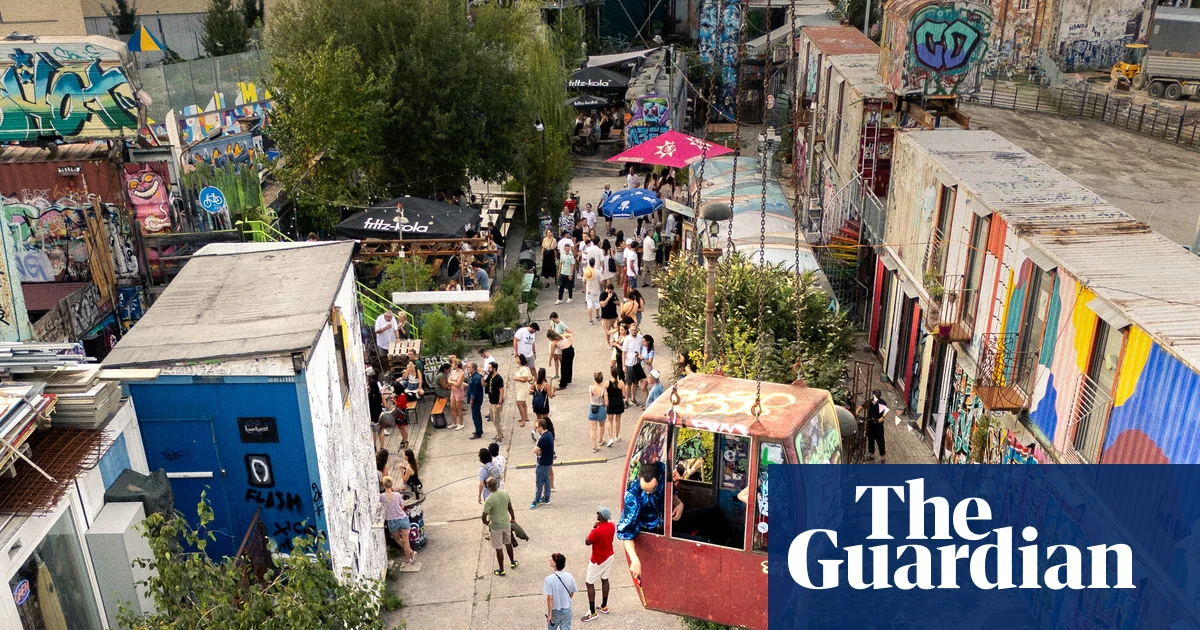
In the south-west of Munich, Schlachthofviertel is an area in flux; a jarring district that is home to a theatre, a techno club and a controversial active slaughterhouse.
In the 1870s, after the final cholera epidemic in Munich, a municipal slaughterhouse (Schlachthof) was built on what was then the outskirts of the city as part of a wider effort to improve hygiene standards. Although it is still in use today, the site has dramatically decreased in capacity, and creative entrepreneurs have been quick to see the potential of unused spaces.
In 2021, the Münchner Volkstheater (People’s Theatre) moved to the area, bringing a new cultural status and sparking fears of accelerated gentrification. For me, it’s a part of town I go to for a change of scene or just a loaf of double-baked rye bread. In summer, the open-air spaces come out of hibernation and show a much edgier side to Munich.
Where to eat and drink
Today, butcher’s shops and cult dive bars sit side by side. There has been a flurry of openings; my favourite recent addition is the female-run Mari on Adlzreiterstraße, the street Albert Einstein lived on for much of his childhood. The airy cafe serves a late breakfast, including a Korean option of marinated tofu and miso mayonnaise.
The Brotatelier bakery operates from a shipping container, and bakers use equipment on wheels to maximise the limited space. From the cinnamon buns to the French fougasse bread, all products are prepared with sourdough. “Everybody has time here; we haven’t had a single customer who was stressed or anything like that,” says co-founder Christof Teriete, whose bigger concern is the impact of the fluctuating container temperatures on the sourdough starters.
For drinks, start at Frisches Bier, run by craft brewer Tilman Ludwig. He has his own beers on tap, along with a small selection of other independent labels, such as Bierol from Tirol and Hoppebräu from southern Bavaria.
‘It’s not about comfort, it’s about maximum inspiration.’ Photograph: Fabian Christ
Cultural experiences
On one side of Zenettistraße is the decommissioned cattle market (Viehhof). The red brick walls are now home to the Volkstheater. Launched with a production of Christopher Marlowe’s Edward II, the diverse programme includes the Radikal jung festival, focused on emerging directors, and the U20 Poetry Slam, which invites young writers to present their work.
Next door is Bahnwärter Thiel, the heart of Munich’s underground scene, were graffitied shipping containers and the occasional caravan provide studios for DJs, artists, potters, goldsmiths, bakers (see above) and non-profits. “There’s no central heating or running water in the containers,” says Kati Legge from female creative office High Five, “but it’s not about comfort, it’s about maximum inspiration and the fascinating people around you.”
Raised garden beds add touches of green and upcycled materials are used for sculptures and makeshift walkways. There’s also a bar in an old tram, a restaurant in a train carriage and a techno club open till 6am weekends.
The Viehhof, the city’s decommissioned cattle market, is now home to the Volkstheater. Photograph: Sport Press Photo/Alamy
Where to shop
Rindchen’s Weinkontor has a huge selection of wine stored in a roomy, listed building. At Moss Concept Store on Thalkirchner Straße you’ll find ceramics, glassware and other home accessories.
Don’t miss
Actually quite hard to miss is Alte Utting, a former passenger ship that’s now a bar and event space that fills the length of a bridge over Lagerhausstraße. Destined for the scrapyard after years of service on Ammersee, it was rescued and relocated in 2017 by Wannda, the people behind Bahnwärter Thiel.
Where to stay
There’s little tourist accommodation in Schlachthofviertel, but there are hotels close to the nearby Oktoberfest site. Cocoon Theresienwiese has doubles from around €80 room-only.
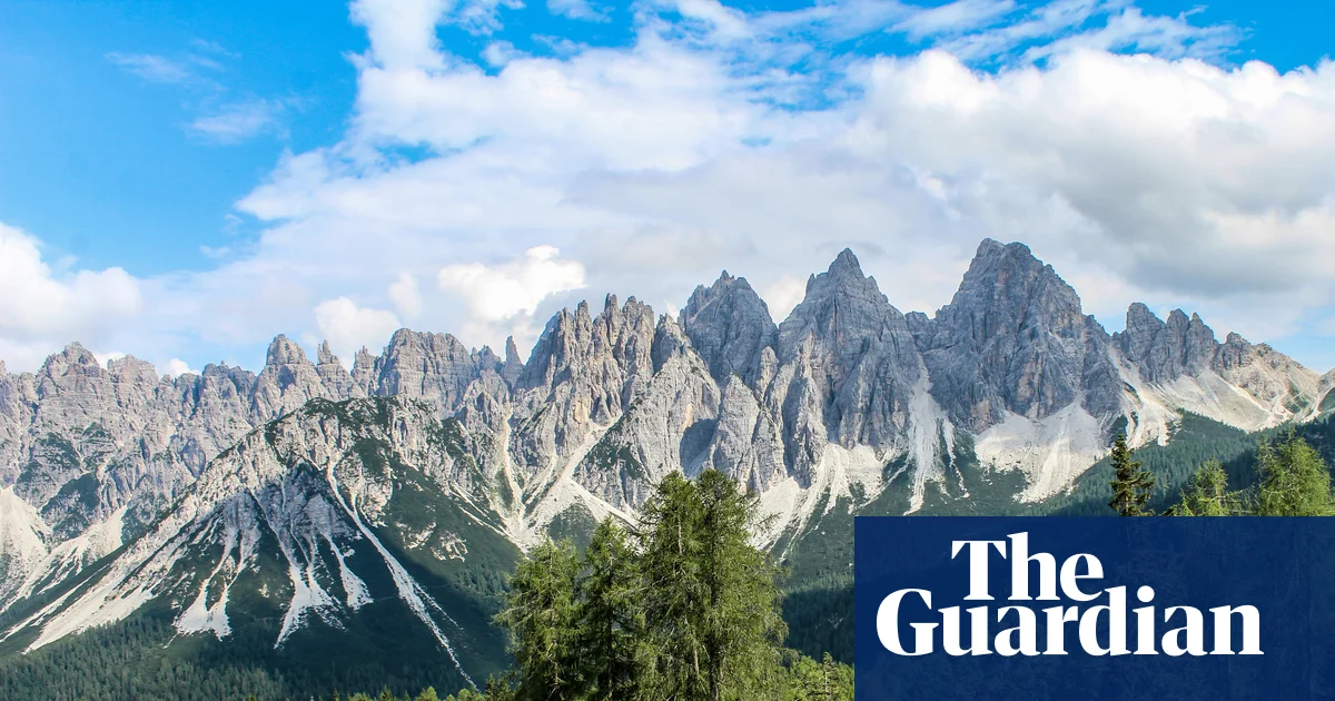
The “forgotten” Dolomites lie to the east, far from the crowds of the Tre Cime di Lavaredo and Val Gardena. Belluno is the main gateway, two hours north of Venice by train or a drive up the A27. From here, the upper Piave valley leads into the quieter Friulian mountains. The land rises gently, opening into pasture, then stone lifting into spires above the meadows.
Traditional local councils, the Regole di Comunità, still manage the land and forests collectively here, sustaining artisans and alpine farmers in scattered hamlets shaped by shared work and resilience. Pastìn (a minced, seasoned blend of pork and beef), malga cheeses and polenta, once staples for long days in the mountains, are still shared over grappa at the end of the day. Beyond the hamlets, paths lead towards Monte Pelmo or drift into the beech woods of Cansiglio, where deer call at dusk. It’s a fine place to experience mountain culture, and these are some of my favourite places.
Alpine lakes and pools
Lago di Calaita is beneath the Pale di San Martino peaks. Photograph: Denis Perilli
The Val del Mis lies west of Belluno, where the narrow SP2 road follows the shore of Lago del Mis. The lake is worth half a day on its own – paddle north by canoe or kayak towards the Cascata della Soffia waterfall, or explore the side gorge of Falcina, where you can swim in still, deep pools of crystalline water under the Passerella del Peron suspension bridge, just off the SR203 past Ponte Mas. Alternatively, from the car park at the northern end of the lake, it’s a 10-minute walk to the Cadini del Brenton – a series of turquoise pools carved into white rock cascading from one basin to the next, some more than four metres deep. A wooden bridge trail leads between them, but bathing here is forbidden.
From the Val del Mis, head north-west towards San Martino di Castrozza, then south through Fiera di Primiero, following signs for the Val Vanoi on the SP79, then climb the road to the spectacular Lago di Calaita, at an altitude of 1,621 metres beneath the ramparts of the Pale di San Martino. At dawn, the rock above is grey; by sunset, the whole massif turns gold. Open meadows line the shore, and Rifugio Miralago serves canederli (bread dumplings) and polenta with tosèla di primiero, the local cheese. In winter, the lake freezes, and the meadows are used for snowshoeing. A two-hour uphill walk leads to the darker Lago Pisorno, said to be haunted.
Mountain viewpoints
From Monte Penna there are spectacular views of Monte Pelmo. Photograph: Denis Perilli
Head for Agordino – the group of valleys along the Cordevole river, south of Cortina d’Ampezzo – for the highest viewpoints. You’ll experience the same massive Dolomite walls but without the crowds. Park near Rifugio Staulanza and take CAI trail 472. In a couple of hours, climbing gently through sparse larch and open grass, you’ll reach the slopes of Monte Penna and look straight at Monte Pelmo’s immense north-west wall – sheer pale rock rising from the valley floor. You’re standing on gentle grass; across the valley, the mountain is vertical stone. The central basin – the Trono di Dio (Throne of God) – is visible in full. To the west is the jagged profile of Monte Civetta.
For a closer look at Civetta, take the old mule track from the hamlet of Piaia, through woods dotted with tabià, the traditional wooden barns used for storing hay at altitude. After a two-hour climb, the trail opens on to the broad pasture of Sasso Bianco, looking directly at Civetta’s sheer face. Note that the road to Piaia is very narrow; parking at the end is limited.
To the south-east, the Alpago basin opens out. From the small Malga Pian Grant farm, the Costa Schienon ridge leads to the rocky peak of Cima delle Vacche at 2,058 metres. It makes for a fine full day’s hike, with the view widening at every step – Lago di Santa Croce shimmers below, and the Dolomites tower beyond.
Farther north, the Campanile di Val Montanaia rises some 300 metres from the floor of its glacial valley. The walk from Rifugio Pordenone takes about three hours over scree and is suited to experienced hikers. The Perugini bivouac beneath the spire offers overnight accommodation – when climbers reach the summit during the day, they ring a small bell, which peals across the valley below.
Restaurants
Outdoor dining at Agriturismo Bon Tajer near Lentia. Photograph: Alberto Bogo
The isolation that once made these valleys hard to reach has also kept their culinary customs intact. Near Lentia in the Valbelluna, Agriturismo Bon Tajer has hundreds of hand-painted wooden plates and chopping boards hanging from the ceilings and walls. Four generations of farmers have run the kitchen where the dishes are made with local herbs and valley produce – egg custards arrive cooked in their own shells, starters come on beds of moss with foraged flowers. Finish with the farm’s own idromele, a fermented honey drink. The mountains glow purple at sunset from the terrace. It’s a 30-minute drive up from Belluno.
Higher up, above Feltre, Malga Campon sits on the summit plateau of Monte Avena. It’s a stone-and-wood hut surrounded by cattle, horses and donkeys grazing freely, with views across the Vette Feltrine peaks, the Lagorai chain and the Monte Grappa massif. In early spring, the meadows fill with white and purple crocuses. The food is homemade – thick slices of bread with pastìn and malga cheese, best eaten under a tree with the animals grazing nearby. Malga Campon is also a starting point for hikes across the plateau. It’s a 30-minute drive from Feltre.
Rifugios and farm stays
The cosy, remote Bivacco dei Loff. Photograph: Denis Perilli
In the north of the region, above Domegge di Cadore, the road ends at Rifugio Padova. But hike on up through the woods and meadows surrounding the Casera Vedorcia dairy under the jagged limestone peaks of Spalti di Toro, to Rifugio Tita Barba di Pieve(open June-Sept but book ahead, €50-80 a night including dinner), a gorgeous alpine log cabin. The hike takes about two and a half hours on the CAI 342 and 352 trails, but the rifugio serves delicious meals and has comfy beds. From the nearby viewpoint on Monte Vedorcia, the panorama stretches over the Centro Cadore lake to the Antelao and Marmarole peaks.
For something even wilder, Bivacco dei Loff, which perches beneath the cliff of Crodón del Gevero, is a cosy stone bothy with a fireplace, a loft for sleeping and a table at the window overlooking the Valle del Rujo – on clear days, the view reaches the Venetian lagoon. Below, the Via dell’Acqua follows the stream past ruined mills and washhouses down to Cison di Valmarino. It’s about a 90-minute hike from Passo San Boldo on trail 991. You can’t book and it’s free to stay, so bring a tent in the event it’s full.
In the far eastern edges of the region, the Cansiglio plateau rises into a forested tableland. Agriturismo Filippon is just a 30-minute drive from the A27, hidden in an alpine meadow ringed by fir and beech. Mountain cattle graze the clearing and wild deer also visit. Meals are prepared with farm-fresh goods and there is a barrel sauna and open-air bathtub. The old Gran Bosco de Reme di San Marco, where Venice once sourced timber for boats’ oars, beckons above, and you could walk for days here, lost in mountain air.