breathtaking

I see nothing but hills, ridges and sea: a breathtaking five-day walk around Ireland’s south-westernmost headland | Walking

The Sheep’s Head peninsula is clearly a good place to be a skylark. They seem to warble overhead at every turn, singing their little hearts out – and who could blame them? The hills here are high and heathery, the sea breeze is warmed by the Gulf Stream and the edge-of-the-world scenery is a realm of wild green slopes and endless blue Atlantic. If you had to choose a sky to lark in, the one that crowns this County Cork headland is a bona fide wing-quiverer.

The peninsula wows hikers, too. I’ve come to one of the south-westernmost points on the Irish mainland to trek the Sheep’s Head Way, a long-distance trail opened by the local community 30 years ago this summer. It took serious work to complete – more of which later – but it’s a delight. I’m walking the original 55-mile (88km) loop around the peninsula, although a longer, 63-mile option is now considered the official route. The way attracts a fraction of the numbers drawn to the Kerry Way and Dingle Peninsula trail further north, and thanks to its untrammelled paths and rampant, cliff-edged scenery, the rewards are grand, in every sense.

“Ah, you’ll love it,” enthuses Thérése Linehan of Doire Liath B&B in Bantry, having fuelled me with poached eggs and soda bread for breakfast. “People do.” This colour-splashed harbour town, at the landward end of the peninsula, is the route’s start and end point. I’m setting off on a Friday and the waterside square is busy with market stalls: fresh seafood, local artworks, turbo-strength flat whites. A statue of 18th-century revolutionary Wolfe Tone stares out to sea. I dawdle a while in the chilly May sunshine, then walk west.

The early miles wind up into the range of rounded drumlins that form the spine of the peninsula. Wildflowers speckle the gorse verges; boggy paths squelch underfoot. Soon, the views open up. Bantry Bay to the north, Dunmanus Bay to the south and a belt of shaggy-grassed peaks stretching out ahead. Swallows are cavorting in the wind. I turn and see nothing but hills, ridges and sea. Where is everyone?

The harbour town of Bantry, seen from the Abbey Graveyard. Photograph: Radnor Images/Alamy

Despite being almost at the westernmost limits of the European map, the region is no historical hinterland. Folklore holds that Bantry Bay was the place where feet were first planted on Irish soil, in 2680BC. Millennia later, in 1796, the same bay witnessed an attempted landing by a vast French fleet looking to help local resistance forces against English rule, only to be thwarted by storms. I’m luckier with the weather. Today the bay is sun-stippled and marble smooth.

The themes of this first day – near-empty trails, unbridled scenery, spring birdlife and heady history – set the tone for those that follow. The loop walk is traditionally split into five or six days I’m doing it in five. For the first two, with crags and coastal meadows cascading around me, I pass only sheep. Cuckoos sound from woodland patches, stonechats flit between rocks, squadrons of hooded crows glide overhead. High, lonely stiles come in their dozens; abandoned 1840s stone homesteads stand sentry above the sea.

At one point the trail ascends to a 345m (1,130ft) viewpoint known as Finn McCool’s Seat, where the legendary giant is said to have sat and rested. I do the same, gazing at the peninsulas further north. I don’t know whether, like me, McCool was sapped enough to wolf down two packets of Taytos while he lingered.

There are few settlements on the first half of the anticlockwise route, so prearranged road transfers take me to and from Bantry to the trail on the first two days. The town has the advantage of myriad pubs and restaurants. Ma Murphys bar, 185 years old, does a fine drop of Murphy’s – which often outsells Guinness in these parts – and sets things up nicely for what is arguably the scenic climax (and far and away the busiest part) of the walk, a roller-coaster trek on Day 3 out to the lighthouse on the promontory’s furthest cliffs.

Roancarrigmore Lighthouse, Bantry Bay. Photograph: Richard Cummins/Alamy

I reach it in early afternoon. The sea is huge and aglitter. Gannets patrol the waves. To the south, across Dunmanus Bay, is Mizen Head, traditionally the last finger of Irish land seen by people sailing to North America. The Sheep’s Head path now spins on its heel and heads east, past a wayside shrine and a tea-and-toasties cafe. Within half an hour the trail is deserted again, its yellow markers leading back into the tussocky green of the hills.

The trail is so well signed that it’s easy to overlook the complexity of shaping a hike around an entire peninsula. The Sheep’s Head Way has an office in the village of Kilcrohane, my base for that night, where I meet local farmer James O’Mahony. Now 82, he was one of the original mid-1990s founders of the trail, along with the late Tom Whitty, a Philadelphian who fell in love with the region. They envisaged a hike that would promote the peninsula’s charms to the full, benefiting not just walkers but local communities. Setting it up, however, required effort.

“There’s no crown land in Ireland, it’s all freehold,” explains James, speaking softly in a thick Cork accent. “We had 265 different landowners to speak to, all on the route. Some of the farmers couldn’t believe their land might appeal to hikers. They’d say, ‘Why would anyone want to walk my old hill?’” He chuckles. “One of the aims was also to keep our old pathways alive. Lots of them were funeral paths, mass paths, church paths. That was very important.”

Yellow waymarkers show the way on the main ridge of the Sheep’s Head Way, Ireland Photograph: Ben Lerwill

The trail took 18 months to complete. While never overcrowded, it has won wide recognition, including a European Destination of Excellence Award in 2009 for “respecting its protected environment while meeting the needs of local residents and visitors”. All landowners on the route still receive an upkeep payment from the government’s rural affairs department, a committee of volunteers oversees the trail and a small, grant-funded team of workers is tasked with maintaining it.

The next day, I’m back on the trail. The 11-mile stretch from Kilcrohane to Durrus, my last staging post before a final day’s walk back to Bantry, is as all-enfolding as all that’s come before. There are historical gems – including a bronze age stone circle and the ruins of a bardic school that, by some local accounts, can claim to be one of Europe’s oldest universities – and more of those coastal views.

There’s a feeling you get when you complete a long-distance trail, a sweet fatigue that holds a sense of the miles walked. This is a special corner of a special county, and the trail that snakes its way around the peninsula – soggy in places, steep in others, but rarely less than spectacular – is one to be celebrated.

The trip was provided by Tourism Ireland and Ireland Walk Bike Hike, which offers seven-day Sheep’s Head Way sel-guided packages, with five days of hiking, B&B accommodation, transfers and luggage transfers from €885. Five-day packages also available. For more information on the Sheep’s Head Way, visit thesheepsheadway.com


Source link

The breathtaking Irish island with hundreds of puffins, ferry trips & stunning coastal views perfect for summer day out

A TINY island off the coast of Wexford could make for one of Ireland’s most spectacular summer day trips.

The breathtaking Saltee Islands are just a two-hour drive from Dublin — with a short ferry ride from Kilmore Quay bringing visitors straight to Great Saltee.

The Saltee Islands is ideal for a summer day out
Razorbills, puffins and gulls can all be spotted at the brilliant bird sanctuary

The islands are famed for their incredible wildlife, with puffin-watching a must for anyone visiting during the summer months.

Day trippers can spend around three-and-a-half hours exploring the stunning island, spotting seabirds, seals and dramatic coastal views.

And with return ferry tickets costing €40 for adults, it could be the perfect seaside escape to kick off the summer.

The islands are located just 5km off Kilmore Quay in Co Wexford — and a 20-minute ferry trip is all it takes to get there.

HIDDEN GEM

Island with only Irish cable car, whales & dolphins near most colourful village

Fabulous views across the sea Credit: Design Pics RF – Getty
A black backed seagull with three chicks spotted on the Saltee Islands

Parking is available at Kilmore Harbour in the free public car park.

However, the little harbour is a busy spot during the summer months.

Visitors are advised to leave plenty of time to get to Kilmore Quay as parking spaces can be limited.

The ferry service picks visitors up at the top of the harbour in Kilmore Quay, beside the boat launching slip.

It brings passengers straight to Great Saltee, as permission to visit Little Saltee cannot be granted due to hazardous landing conditions.

But visitors can only access the island during certain hours each day.

Day trippers are allowed on the island between 11am and 4.30pm, and anyone landing on a boat outside these times will be asked to leave.

The popular Saltee Ferry is a daily service that runs from April to October every year.

A return ticket costs €40 for adults and €20 for children under 12.

Each ferry can carry up to 12 passengers at a time.

Visitors are advised to arrive at the ferry gate ten minutes before the trip.

A smaller transfer boat will meet the ferry just off the shore of the island.

It picks passengers up and brings them on the final part of the journey to Great Saltee.

Once you arrive, you will be given approximately three-and-a-half hours to explore the mesmerising island.

The ferry crew will give you an exact time to be back at the landing area for the return trip to Kilmore Quay.

The ferry trip can be booked in advance online at salteeferry.com.

The Saltee Islands are known as the most famous bird sanctuary in Ireland — and puffin-watching is a must on any trip there.

Puffin season is predominantly between May and June.

There are plenty to spot, so make sure to take lots of pictures.

One visitor said: “The trip of a lifetime. There were hundreds of puffins just a short stroll from the boat. If you sit quietly they’ll wander around you.”

But Discover Ireland chiefs have warned that the puffin population is in a dangerous position, and visitors are advised to keep their distance to avoid disturbing the wonderful birds.

As well as the magnificent puffins, the island is also home to an array of seabirds, from gannets and gulls to Manx shearwaters.

While exploring the picturesque island, you might also come across some friendly sea creatures.

Grey seals are known to breed around the Saltee Islands.

It is one of the very few places in eastern Ireland with a seal population.

Up to 120 animals are present in autumn and up to 20 pups are born annually.

The seals can regularly be spotted resting on the rocks around the island.

The Saltee Islands are among the most ancient islands in Europe.

As long ago as 3,500 to 2,000BC, people were living on the islands.

In December 1943, the Saltees were purchased privately by the late Prince Michael the First.

Since his death in January 1998, the islands have been owned by his five sons and one daughter.

Permission for people to visit the island was granted by the family in recent years — but visitors are asked to respect the island.

When the family is in residence, a flag will be flying at the house — which visitors are asked not to approach.

No one is allowed to stay or camp at the historic spot, but there is no admission fee for a day trip to the island.

But island chiefs have issued a major warning to visitors.

They said: “Please do not approach the nesting birds closer than six metres.

“The footfall is having a devastating effect on the bird population. Should visitors see photographers not obeying the signs, please explain to them that they are killing the birds and to use their lens instead of their feet.

“If things do not improve with the bird population due to the current footfall, we will be forced to close the island to visitors.”

Source link

Unique bridge where you can see four countries at once with ‘breathtaking view’

There’s only one place in the world where you can see four countries at once, thanks to a bridge that has been carefully created to connect two countries while avoiding two others

There are some rather impressive, architecturally brilliant bridges dotted across the world. But there’s one that might be the most striking of all, as it allows visitors to see four countries at once.

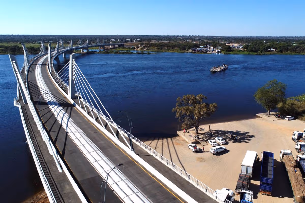
The Kazungula Bridge might not be the most beautifully designed structure in the world, but its elaborate positioning over the Zambezi River is situated in one of the most bizarre locations in the world. The 3,028ft (923m) long and 60.7ft (18.5m) wide bridge serves as a major route through Africa, connecting Zambia and Botswana.

It consists of a two-car lane, a single railway track, and pedestrian walkways on either side, and was opened in May 2021. But what’s fascinating about this bridge is that while it connects Zambia and Botswana, there are two other countries on either side, Namibia and Zimbabwe.

READ MORE: British Airways warns passengers taking certain photos can be kicked off flightsREAD MORE: Europe’s ‘most beautiful beach’ with pristine sands is just 3 hours from UK with £28 flights

It was designed to accommodate complex border crossings between two countries, while being a stone’s throw from two others. This means that those using the bridge, which spans across the world’s second-shortest border, can see Botswana, Namibia, Zambia, and Zimbabwe simultaneously.

However, there’s more to this unusual geographical mastermind.

Maps show that this area is the world’s only quadripoint, meaning it’s the only place where four countries meet. This is known as the Kazungula Quadripoint, with Botswana, Namibia, Zambia, and Zimbabwe all meeting in the middle of the Zambezi River.

Many countries border two or three nations, but it’s incredibly unusual to have four countries connected. Instead, there is a North American quadripoint in the USA where the states of Arizona, Colorado, New Mexico, and Utah meet, as well as a sub-national quadripoint in Canada where the provinces of Manitoba, Saskatchewan, the Northwest Territories, and Nunavut meet.

While the Kazungula Bridge that passes the four connected countries has been widely known as the world’s only quadripoint, some believe this isn’t the case at all. Big Think reported that if the map of where the four countries connect is examined closely, the “point disappears”, and instead, the “quadripoint turns into two tripoints”.

The western point is claimed to be where Botswana and Zambia meet Namibia, while the eastern point is where the three countries meet Zimbabwe. Yet its confusion is valid, and remains relatively unconfirmed, with claims that the points are separated by more than a mere 443 feet (135m).

Regardless of its argued status as the world’s only quadripoint, it remains starkly impressive that visitors can see four countries at once. And it still remains as the only place in the entire world where you can witness such a marvel.

One traveller who got the chance to use the remarkable structure wrote on TripAdvisor: “This is a bridge that connects Botswana and Zambia via the mighty Rivers, Chobe River and Zambezi River, and this is the point where four countries meet at one point, right in the middle of the Bridge. A very breathtaking view and good sunsets on the bridge, it’s a good place to be and take pictures.”

Do you have a travel story to share? Email webtravel@reachplc.com

Source link

The ‘breathtaking’ UK beach that’s just like the Mediterranean but without the crowds

This charming coastal spot is one of the most beautiful beaches in the UK.

Summer is approaching, and if you’re already fantasising about sea and sunshine, then you’re truly spoilt for choice. While destinations such as the Mediterranean and the Caribbean are alluring, flying overseas can prove costly – without even mentioning accommodation prices and dining expenses.

Fortunately, if you’re watching your pennies, the UK boasts some genuinely breathtaking destinations to discover, right on your doorstep. Not only will it prove more affordable, it will also eliminate much of the hassle involved in organising an overseas getaway. Instead of dashing through airport security, all you need to do is jump in the car or board a train.

Staycation specialists at holidaycottages.co.uk have examined some of the globe’s most sought-after beach destinations and recommended lesser-known UK alternatives that deliver all the splendour of the finest spots but without the hefty price tag or the throngs of visitors.

The Costa Brava ranks as an extremely popular destination for British holidaymakers.

Renowned for its white sand beaches, verdant landscape and turquoise waters, this north-east Spanish hotspot frequently draws crowds of British tourists seeking to unwind by the sea, reports the Express.

For a more tranquil and budget-friendly option, Porthcurno Beach in Cornwall serves as the UK’s own slice of paradise.

The beach sits beneath towering cliffs that shield it from the wind, while the stunning clear waters prove ideal for swimming and snorkelling.

One visitor wrote on Tripadvisor the beach was “absolutely breathtaking”.

“The most amazing beach beautiful white sand and turquoise sea. Breathtaking views and definitely one of the best beaches you will ever find.”

Another said: “Spent the day here, it’s just like being abroad, clear blue skies water, perfect sandy beach and so peaceful. No arcades, no boats, no noise, just gorgeous.”

Sarah Pring, PR manager at holidaycottages.co.uk, said: “For many people, summer brings the temptation of a beach holiday, however, travel enthusiasts don’t have to travel internationally to experience crystal-clear waters and beautiful sandy beaches hidden between towering cliffs as there are many comparable spots in the UK.”

The most stunning beach alternatives in the UK

  • Luskentyre Beach, Scotland – looks like Turks and Caicos
  • Porthcurno Beach, Cornwall – looks like Costa Brava, Spain
  • Runswick Bay, Yorkshire – looks like Monterosso Al Mare, Cinque Terre, Italy
  • Barricane Beach, Devon – looks like Calanque d’En-Vau, France
  • Porthdinllaen, North Wales – looks like Hout Bay, Cape Town, South Africa

Source link