wildflowers

Scotland in bloom: wildflowers turn the Outer Hebrides into a Technicolor dream | Scotland holidays

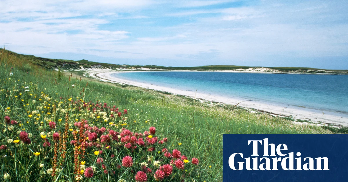
Some 8,000 years ago, behind the retreating glaciers, a remarkable environment was born on the western fringes of Scotland’s Outer Hebridean islands, forged by the wind and waves. It began with rising sea levels and sweeping Atlantic gales depositing crushed shell-sand inland; this settled over glacial sediment to form a coastal belt of lime-rich soil. Buffered from the sea by mounting sand dunes, this winter-wet and summer-sunned substrate produced one of Europe’s rarest habitats: the “machair”, Gaelic for “fertile grassy plain”. Abounding in diverse, colourful wildflowers and an array of associated wildlife, coastal machair is a precious, globally important outpost of biodiversity, supporting everything from purple orchids and nodding blue campanulas to endangered birdlife, otters and rare bumblebees.

As a wildflower fanatic, visiting the Outer Hebrides in peak machair bloom has long been an aspiration. Over the years, I’d read accounts of its arresting, vibrant seasonality – its shifting blankets of red and white clover, yellow trefoil and creamy eyebright, bold against the sky. Although remnant machair is also found in north-west Ireland, its greatest extent lies on this Scottish archipelago, notably the islands of Barra, Uist and Harris.

Moreover, here it has a fascinating symbiotic relationship with crofting, the traditional, small-scale agriculture unique to Scotland’s Highlands and Islands. For generations, crofters have managed areas of machair as low-intensity pastureland, improving its fertility, grazing livestock and growing crops on sustainable cycles sympathetic to wildlife regeneration. With crofting undergoing a quiet resurgence on the islands, and many crofters exploring new ways of sustaining an old way of life, experiencing the Outer Hebrides appealed to me all the more. Last summer, I finally made the trip, travelling from Barra in the south right up to Lewis – and it was everything I had hoped for.

Now a parent of two young boys, and with the machair’s flowering season falling squarely within the school holidays, it was clear this trip would need to be a family affair. I pitched it to my wife: “Fancy a holiday of white sands, turquoise waters and local food?”

“Sicily? Sardinia? Greece?” came the expectant reply.

The Isle of Barra, ‘unquestionably one of the prettiest islands’. Photograph: Ian Rutherford/Alamy

Thankfully, she was won round with the promise of fresher-than-fresh salmon, unrestricted space to exhaust the boys and, appealing to her interests in history and design, the islands’ heritage of traditional crafts. But there was one other necessary sell: in order to cover all islands in one go, and to allow for surprise and discovery, we’d need to travel by motorhome. Having spent last summer negotiating the confines of a family tent, this, too, was agreed. With swivelling car seats, a three-hob stove and a sky bed deemed certifiable upgrades, we were off.

Collecting our motorhome from Just Go outside Edinburgh and driving the mountainous, lochside road towards the west coast, we spent two nights at pleasant North Ledaig caravan park, outside Oban, the primary port for the Western Isles. Perched beside the placid waters of Ardmucknish Bay, we underwent some necessary pre-island preparations: namely, getting to grips with motorhoming essentials (wastewater disposal, tethering breakables, navigating single lanes), and refamiliarising ourselves with the inescapably chaotic nature of travelling with small children. Thus decompressed, we were borne across the Sea of the Hebrides on a CalMac ferry to Barra, the second most southerly of this spectacular island chain.

As I had read multiple times when researching this trip, the Isle of Barra is not to be overlooked. At a mere 9 by 7 miles, it is among the smaller islands, but unquestionably one of the prettiest. A short, easy drive from the landing at Castlebay village – marked by medieval Kisimul Castle, protruding from the water – brought us to Borve Camping & Caravan Site, where we pitched in view of waves crashing upon blackened gneiss boulders.

Over the next two days, we explored the quiet, colourful island and that of smaller Vatersay (connected via a causeway), hiring bikes, taking coffee mugs on to the marram grass dunes, and making sand tunnels at stunning beaches Traigh a Bhaigh and Tangasdale. Approaching the latter, I got my first taste of machair, my heart singing when suddenly surrounded by yellow bedstraw and kidney vetch, red bartsia and scattered orchids. A magical quality of machair, I quickly learned, is that its detail can appear disguised at a distance, owing to the complexity of species. Once up close, thousands upon thousands of low-lying flowers are revealed in an effect akin to pointillism.

The writer’s wife and youngest son on Traigh a Bhaigh beach on the Isle of Barra. Photograph: Matt Collins

Machair has hosted crofts for centuries, its light, workable soil contrasting with the rocky peatland often prevalent across the islands. Considered a semi-natural habitat, it is sustained by the low-intensity agriculture practised by crofters: locally harvested seaweed (kelp) is spread as an organic fertiliser, enriching and preserving the sandy soil and providing sustenance for migrant birdlife. Similarly, cycles of crop and fallow benefit wildflower regeneration and support ground-nesting birds, while silage harvesting is carefully timed to protect endangered species such as the corncrake.

Some of the most impressive machair is found at the RSPB reserve of Balranald on North Uist, where the mixture of fallow wildflower fields and areas under cultivation (for cereals such as barley, black oats and hebridean rye) shows as a subtle patchwork over the landscape. Camped on the reserve itself – our highlight campsite – my eldest and I spent a memorable evening wandering back from the beach through the engulfing blooms.

While on South Uist, we visited crofters DJ and Lindsay of Long Island Retreats & Larder, who subsidise their livestock crofting by hosting island experiences, from island and machair tours to sheep shearing demonstrations.

“Our love of the land and the livestock is what drives us,” Lindsay told me, meeting at the smart “larder” shop that she and DJ – a sixth-generation crofter – run from their home at Loch Skipport. “But we wouldn’t be doing what we’re doing if it weren’t for all the people that came before us.”

Lindsay said it is common for crofters to have second jobs, but having started a family, they sought new avenues to make their crofting more viable. In recent years, the Scottish government’s crofting agricultural grant scheme has made money available for agricultural improvements, business development and croft house refurbishments, encouraging many crofting families to diversify their income streams.

Machair has hosted the small-scale agriculture of crofts for centuries. Photograph: Matt Collins

Farther north on Harris, we stopped by Croft 36, a crofting enterprise that’s part of the growing Outer Hebridean culinary scene. Operating from an unmanned honesty-box kiosk, Croft 36 offers homemade soups, pastries and other baked produce made with machair-grown ingredients.

Our journey was punctuated by memorable meals, almost all of them found at a pop-up of one kind or another, often out in the wilds: the scallop and black pudding bun devoured at The Wee Cottage Kitchen food van on the North Uist coast; the salmon at Namara Seafood Cafe. On Lewis, the Crust Like That takeaway pizzeria – a shipping container isolated in dramatic moorland – offered haggis-topped pizza. And don’t get me started on the cake-packed honesty boxes dotted around like treasure chests.

The freedom of the motorhome meant that these and so many other discoveries could be enjoyed along the road. Travelling the islands this way gave a great sense, too, of their shifting character – of Barra and Eriskay’s pristine coves, Uist’s freshwater lochs, and the hilly, moorland drama of Harris and Lewis.

By the time we were heading back to Edinburgh from Ullapool, I was losing count of the special moments. We’d seen peregrines, hen harriers, basking seals and diving gannets, and spent evenings off-grid on breathtaking remote beaches. We’d swum sunlit coves (none more sparkling than at Eriskay and west Berneray) and made hot chocolate for the boys on the pebbles. When it rained, there were heritage museums, charming cafes and woollen mills; Stornoway’s An Lanntair arts centre and the poignancy of Geàrrannan Blackhouse Village in Lewis, its restored 19th-century drystone houses conveying the challenging life of a once prominent crofting community.

And the machair left an impression not easily forgotten: a rare floral spectacle I now understand as a lifeblood of these islands.

The trip was provided by VisitScotland and the Caravan and Motorhome Club.

Source link

3 hikes near L.A. where wildflowers are thriving right now

I went to the Santa Monica Mountains on the hunt for wildflowers.

I was nervous. What if I found absolutely nothing? I’d used data collected by plant lovers during previous blooms and checked on iNaturalist, a citizen science app, about where wildflowers had recently been noticed to discern where I’d be most likely to find blooms.

But, even then, I knew the unusual spring heat wave that prompted some wildflowers to bloom early could have also killed them. I knew the heat had already zapped the bright orange beauties at the Antelope Valley California Poppy Reserve. What if I’d already missed this annual springtime magic?

You are reading The Wild newsletter

Sign up to get expert tips on the best of Southern California’s beaches, trails, parks, deserts, forests and mountains in your inbox every Thursday

It was with this level of eagerness and anxiety I recently entered the Santa Monica Mountains. I feel more than lucky to have discovered a resplendent rainbow of native plant blooms.

I hope you also witness this abundance on the three trails below. L.A. is forecast to have more springtime rain, and you know what they say about April showers!

If not, though, I want to underscore that regardless of their foliage, each hike offers its own unique adventure, one I’d take in any season.

Funky pink and light yellow flowers grow out of a plant with pink and green stems around a dirt trail surrounded in foliage.

Chaparral bird’s-foot trefoil blooms in thick patches throughout the Saddle Peak Trail.

(Jaclyn Cosgrove / Los Angeles Times)

1. Saddle Peak via Backbone Trail

Distance: 3.3 miles out and back
Elevation gained: About 860 feet
Difficulty: Moderate
Dogs allowed? No
Accessible alternative: Inspiration Loop Loop ADA Trail at Will Rogers State Historic Park

This 3.3-mile route to Saddle Peak takes hikers up a lush hillside with sweeping views of the nearby Calabasas Peak, the San Fernando Valley and, toward the top, the Pacific Ocean. Visitors will observe a landscape that features not only a diversity of wildflower species but also ancient sandstone formations.

You’ll start your hike by parking on the side of Stunt Road, a winding paved street with sharp turns popular among cyclists and drivers of very fast sports cars. There is limited parking here, so it’s good to either arrive early or hike this trail on a weekday. Additionally, the parking area on the side opposite the trailhead is near a steep drop-off so take good care if parking there.

A narrow dirt path through thick purple flowers and other plants with a massive angular boulder on the hillside.

The Saddle Peak Trail features multiple stretches where wildflowers grow close to the trail.

(Jaclyn Cosgrove / Los Angeles Times)

The trailhead sits just south of the road and is well-marked with large signs, including one that warns you that smoking, bicycles and dogs are prohibited on the trail. (Apologies to your cigar-loving circus canine.)

You will first take the short Stunt Road connector trail about 0.2 miles before bearing left, or east, onto the Backbone Trail to Saddle Peak. You’ll immediately start noticing wildflowers.

Chaparral bird's-foot trefoil, mini lupine, purple nightshade, showy penstemon, golden yarrow and large-flowered phacelia.

Chaparral bird’s-foot trefoil, clockwise, mini lupine, purple nightshade, showy penstemon, golden yarrow and large-flowered phacelia.

(Jaclyn Cosgrove / Los Angeles Times)

I have dubbed myself a “lupine freak” because of my obsession with this genus of plants — not because I enjoy howling at the moon once a month — and I paused just a third of a mile into this trail. “You look like a tiny little lupine,” I said to the short plant with purplish blue petals near my right foot. Turns out it was indeed a miniature lupine!

This would be the first of many delights. Within a half mile on the trail, I’d already spotted golden yarrow, bush poppy, purple nightshade and black sage abundant with purple blooms. And canyon sunflower covers substantial portions of this trail. This suggests the trail burned in recent years, as canyon sunflower is a fire follower.

There’s also a fair amount of California sagebrush, which you can run your fingers along and smell its delicious aroma (which I think smells like spicy Italian salad dressing).

Small boulders amid small white flowers and green foliage with a view of the blue ocean and horizon in the distance.

The view from a bench at a lookout point near the Saddle Peak Trail in the Santa Monica Mountains.

(Jaclyn Cosgrove / Los Angeles Times)

As I hiked onward, I started to feel like Julie Andrews in “The Sound of Music” because the hills really were alive! I squinted at one plant I had no memory of seeing, a pink and green plant with bright pink and lemon chiffon-colored petals. Had I finally stumbled upon one of California’s rare, threatened or endangered plants?

I was so eager to Google this floral mystery. Later, I learned it’s a not-so-rare (but oh-so-beautiful) chaparral birdsfoot trefoil. It grew thick throughout the second leg of this trail, a real visual feast!

I briefly hiked through a lull where the trail was beautiful but not bursting with colors outside green and brown. Then, I came around another corner to find more trefoil, large-leaf phacelia and showy penstemon, which would be a great native plants-inspired drag performer name.

A huge rock wall with varying sizes of holes washed into it by centuries of weathering.

A massive sandstone rock wall along the Saddle Peak trail.

(Jaclyn Cosgrove / Los Angeles Times)

Very suddenly, after staring at plants for more than an hour, I looked up and realized I’d reached the massive ancient boulders. I watched as white-throated swifts dived in and out of the rock’s pockets where it might be considered tafoni (maybe!). Fun fact: These birds use “their saliva to glue a little cup of twigs and moss to the vertical wall” to build their nests, according to Cornell Lab of Ornithology.

You’ll take a few well-maintained sets of rock steps up, also navigating some rocky and, at times, somewhat washed-out portions of the trail. Take good care to look before you reach toward a rock for leverage so you don’t end up grabbing a danger noodle (read: snake).

About 1.3 miles in, you will crest a hill and be greeted with gorgeous views of the deep-blue ocean. From here, you can continue up to Saddle Peak, which features more massive rock formations.

I hiked over to a bench at an overlook point just past a few (invasive but pretty) Spanish broom plants. Here, I took stock of the day, savoring both the burrito I packed and the good day I’d had. I don’t know whether anyone would label it “super,” but I found myself chuckling over simply calling it a superb bloom.

A narrow dirt path through the middle of a hillside replete with foliage including yellow and white flowers.

The Musch Trail in Topanga State Park.

(Jaclyn Cosgrove / Los Angeles Times)

2. Backbone Trail to Musch Trail Camp

Distance: 2 miles out and back (with option to extend via a loop back)
Elevation gained: About 200 feet
Difficulty: Easier end of moderate
Dogs allowed? No
Accessible alternative: Musch Trail road, a 0.6-mile out-and-back trek on a paved path from the parking lot

This two-mile, out-and-back jaunt through Topanga State Park takes you through lush meadows and chaparral where you’ll be near destined to spot wildflowers and wildlife.

To begin your hike, you’ll park at Trippet Ranch and pay to park before heading out. The Musch Trail starts in the northeast corner of the lot. You’ll take the paved path just 1/10 of a mile before turning east onto the dirt path, the Backbone Trail.

Collage with an indigo flower with a yellow center; off white flowers with flowering stems that resemble caterpillars & more.

Caterpillar scorpionweed with southern bush monkeyflower nearby, clockwise, purple owl’s clover, canyon sunflower, dodder over black sage, California poppy and western blue-eyed grass.

(Jaclyn Cosgrove / Los Angeles Times)

The ranch was originally called Rancho Las Lomas Celestiales by its owner Cora Larimore Trippet, which translates to “Ranch of Heavenly Hills.” You’ll find, as you hike through those hills covered in oak trees, black sage, ceanothus and more, that the name still rings true today.

I also spied significant blooms of orange-yellow southern bush monkeyflower, canyon sunflower, golden yarrow, a species of Clarkia, light purple caterpillar scorpionweed and exactly one blooming California poppy plant (just past the pond).

A mile in, you’ll arrive at Musch Trail Camp, a small campground with picnic tables and log benches. As you pause, listen to the songs of the birds. California quail, Anna’s hummingbird and yellow-rumped warbler are commonly spotted. Stay quiet enough, and you might just spot a mule deer, desert cottontail or gray fox. On a recent visit, I went to refill my water bottle at a spigot next to the camp, only to discover a Southern alligator lizard lounging in the path.

From the trail camp, you can either turn around or continue northeast to Eagle Rock, which will provide panoramic views of the park. From Eagle Rock, many hikers take Eagle Springs Fire Road to turn this trek into a loop. Regardless of which path you take, please make sure to download a map beforehand.

As the sun sets, golden light blankets the hillsides in Leo Carrillo State Park.

As the sun sets, golden light blankets the hillsides in Leo Carrillo State Park.

(Jaclyn Cosgrove / Los Angeles Times)

3. The Willow Creek and Nicholas Flats Trails

Distance: 1.9 miles with an option to extend
Elevation gained: About 630 feet (excluding extension)
Difficulty: Moderate
Dogs allowed? No
Accessible alternative: Sycamore Canyon Road

This 1.9-mile loop is a mostly moderate jaunt connecting two popular routes in Leo Carrillo State Park. As a bonus, you can head over to the beach after your hike, either to cool down, explore the tide pools or both!

To begin, you’ll park at Leo Carrillo State Park. An all-day pass is $12, payable to the ranger at the gate or via the machine in the parking lot. Once parked, you’ll head northeast to the trailhead. You’ll quickly come to a crossroads. Take the Willow Creek Trail east to officially start your hike.

You’ll gain about 575 feet in a mile as you traverse the Willow Creek Trail. I took breaks along the way to gaze at the ocean, watching surfers bobbing on their boards and a kite surfer trying to gain traction. You might spot coast paintbrush and California brittlebush, a flowering shrub that features yellow daisy-like flowers, on the path, along with several lizards.

Orange, purple and yellow wildflowers.

California poppies growing amid invasive weeds, left, Coulter’s lupine and longleaf bush lupine observed in Leo Carrillo State Park last May.

(Jaclyn Cosgrove / Los Angeles Times)

A mile in, you’ll come to a junction in the trail where you have three-ish options. You can continue west to a branch of the Nicholas Flat Trail that will take you a mile back down to the parking lot. You can head south onto an ocean vista lookout point (which, though steep, I highly recommend). Or you can turn north onto another branch of the Nicholas Flat Trail.

I did a combination, hiking 235 feet up the lookout path, where I had one of those “Wow, I get to live here” moments. The ocean was varying shades of blue, from turquoise to cerulean to cobalt. I could clearly see in all directions, including about eight miles to the east to Point Dume. I was, once again, amazed to be alone in a beautiful place in a county of 10 million people.

Once I finished at this awe-inspiring point, I headed north onto the Nicholas Flat Trail, taking it about 2.3 miles — and about 1,100 feet up 🥵 — through laurel sumac and other coast sage scrub vegetation into the Nicholas Flat Natural Preserve. Along the way, keep an eye out for deerweed covered in its orange and yellow flowers along with scarlet bugler (which hummingbirds love). Other common sights here include Coulter’s lupine and small patches of California poppies.

If you start this hike early enough in the day, you can simply trek back to your car and change into your swimsuit for an afternoon at the beach. And if the tide is out, you might also be able to walk around the tide pools. You could hang out in the same day with both lizards and starfish, and even spy an endangered bumblebee on the trail and an octopus at the beach.

Please, go have yourself a remarkable Southern California day!

A wiggly line break

3 things to do

A person's silhouette as they stand on the beach, letting the waves crash into their shins.

A person takes in the sunset on the beach in Venice.

(Michael Blackshire / Los Angeles Times)

1. Watch the sunset with new friends in Venice
Sunset Club L.A. will host a free community gathering at 6:15 p.m. Thursday at Venice Beach. Guests will meet in front of Fig Tree (431 Ocean Front Walk #2402) before setting up camp on the nearby beach to watch the sunset together. Learn more at the club’s Instagram page.

2. Take a peaceful jaunt in L.A.
L.A. for the Culture Hiking Club will host an adventure at 10:30 a.m. Saturday through Griffith Park. The group will take a 2.6-mile hike that includes the Ferndell Nature Trail. Afterward, guests will hang out at the Trails Cafe near the trailhead. Register at eventbrite.com.

3. Find a new kind of ‘dume’ scrolling in Malibu
California State Parks needs volunteers to help remove invasive plants from 9 a.m. to noon Saturday at Point Dume. Park workers will guide participants on removing weeds while cultural resource staff will teach volunteers about the ecological and cultural importance of the site. Register at eventbrite.com.

A wiggly line break

The must-read

A large empty pool with a two-story pool house with red tile roof, wooden trellises and Spanish Colonial Revival features.

The Griffith Park Pool has remained fenced in and closed for six years, but there are plans now to renovate and reopen the pool.

(Gina Ferazzi / Los Angeles Times)

Who is ready to take a dip at the Griffith Park historic swimming pool? That might become a reality by July 2029. Times staff writer Christopher Reynolds wrote that city officials aim to give the facility at Riverside Drive and Los Feliz Boulevard, which dates to 1927, a three-year, $40-million facelift. The new design will feature two new pools and rehabilitate the site’s pool house. Officials closed the pool in early 2020 amid COVID-19 shutdowns and later discovered when they tried to refill it that the pool wouldn’t hold water.

I cannot wait to take a hike and then a swim at the same public park!

Happy adventuring,

Jaclyn Cosgrove's signature

P.S.

Are you ready to transition from hiking around native wildflowers to planting them? Come meet experts from the Theodore Payne Foundation and the California Native Plant Society at the L.A. Times Plants Booth during The Times’ Festival of Books at USC on April 18 and 19. If you sign up for the L.A. Times Plants newsletter, you’ll receive Jeanette’s Mix, a special packet of sunflower and California poppy seeds named for our beloved L.A. Times plants writer Jeanette Marantos, who died in February. I am volunteering at the booth on April 18 and would love to meet you!

For more insider tips on Southern California’s beaches, trails and parks, check out past editions of The Wild. And to view this newsletter in your browser, click here.


Source link

Towsley Canyon in Newhall has shade, wildflowers and a seasonal creek

I heard the ribbit of a Pacific chorus frog and couldn’t stop my feet as they veered me off the official trail and onto a foot path leading down to Wiley Creek.

I grew up with a pond in the pasture behind my house where I could listen to the riotous sound of amphibians any evening I wanted. The soundscape of freshwater habitats is such a comfort to me.

I sat down on a boulder near the water, trying to remain still. The frog had quieted after spotting me, and I hoped it would restart its song, understanding I was not a threat but instead just a big fan.

This was the first of many beautiful moments I experienced on my recent hike through Ed Davis Park in Towsley Canyon in Newhall. It features shady canyons with blooming wildflowers and wildlife that appear to be thriving. I would later learn that a walk through Towsley Canyon is also a journey through the history of environmental activism in the Santa Clarita Valley. This area was once slated to become a landfill.

You are reading The Wild newsletter

Sign up to get expert tips on the best of Southern California’s beaches, trails, parks, deserts, forests and mountains in your inbox every Thursday

Today, hikers can explore the area by visiting Ed Davis Park in Towsley Canyon, one of four recreation areas that make up the 4,000-acre Santa Clarita Woodlands Park. (The other three are East and Rice canyons, Pico Canyon and Mentryville, each of which are also worth exploring.)

And because I got confused by this, I will point out: The Rivendale Park and Open Space is also nearby, at the mouth of Towsley Canyon near the northeast corner of Ed Davis Park. So you could find yourself hiking along one of its trails as well.

Ed Davis Park offers access to multiple trails, including:

Various wildflowers found along a trail.

Clockwise, southern bush monkeyflower, blue dicks, phacelia, California poppy, a flower and purple nightshade that appears to be a collinsia heterophylla.

(Jaclyn Cosgrove / Los Angeles Times)

I arrived at Ed Davis Park just after 9 a.m. last week with a plan to take a short hike, given the high temperatures forecast that day. I parked near the entrance in the large dirt free lot. Note: There were no restrooms or portable toilets that this outdoors reporter could find anywhere nearby, so plan accordingly.

From the parking lot, I headed west, quickly turning south onto Wiley Canyon Trail. I was immediately greeted by a lesser goldfinch, perched on a strand of wild rye like a feathered park ranger.

The trail was initially a bit rutted but quickly smoothed out. As I headed into Wiley Canyon, I found myself in a crisp cool landscape shaded by large oak and California black walnut trees. I quickly heard running water. When I checked the thermometer hanging on my backpack, it read 69 degrees.

Clockwise, lesser goldfinch, western whiptail, convergent lady beetle and a lizard.

Clockwise, lesser goldfinch, western whiptail, convergent lady beetle and a lizard.

(Jaclyn Cosgrove / Los Angeles Times)

Although I could hear nearby traffic and a Southwest plane passing overhead, it didn’t block out the dynamic soundtrack of the canyon’s avian residents: the oak titmouse, northern mockingbird, blue-gray gnatcatcher and Hutton’s vireo, which, according to my birding app, were all above and around me.

As you travel along the canyon, you’ll find purple sage bursting out of the ground, and blue dicks starting to bloom. I passed by several ceanothus with white and blue-violet blooms. I really took my time taking in the native plant landscape and was lucky to spot a convergent lady beetle sipping on dew on a blade of grass.

After my short visit to the creek to find frogs, I was looking up to observe a turkey vulture and red-tail hawk circling overhead, seemingly competing for airspace, when I noticed the California dodder nourishing itself atop several plants on the hillside. Although it is a parasitic vine, this orange otherworldly being does indeed serve an important ecological purpose.

Several strands of a thin orange vine, resembled messy tangled hair, lay over a green plant.

California dodder in the Towsley Canyon area around Newhall.

(Jaclyn Cosgrove / Los Angeles Times)

“Dodder will flower during the hot summer months, providing native insects with a valuable meal and drink during the months when many other California native plants are dormant,” Jorge Ochoa, an associate professor of horticulture at Long Beach City College, wrote for the Friends of Griffith Park regarding the plant’s purpose.

I continued south, passing a spotted towhee digging in the dirt for its breakfast. Then, just under half a mile in, I turned northwest onto the Don Mullally Trail. The trail is named after a naturalist who, according to park signage, “traversed every canyon, led countless hikes to unforgettable destinations, and shared the Woodlands’ unparalleled native tree associations and ecological majesty.” May we all be so lucky!

A narrow dirt path shaded by tall bendy trees.

A shady portion of a trail in the Towsley Canyon area around Newhall.

(Jaclyn Cosgrove / Los Angeles Times)

This is where you’ll start to gain some elevation — and sun exposure. But it’s also where you will find the most blooming wildflowers! I quickly spotted phacelia with bright purple blooms, and as I headed west, an increasing number of California poppies and southern bush monkeyflower.

Lush green mountains with bits of shear brown and white rock showing through the foliage.

Towsley Peak near Towsley Canyon in Newhall.

(Jaclyn Cosgrove / Los Angeles Times)

Ed Davis Park is home to a robust butterfly population. I found a kaleidoscope of pollinators among the wildflowers and weeds, including a checkered white butterfly who was eagerly drinking from invasive mustard. I chuckled to myself. It didn’t seem to mind feasting on one of the most hated plants in Southern California.

The trail does turn into a narrow single track with thick vegetation, so please take good care as you’re hiking. I was very aware of the likelihood that I would encounter a rattlesnake, and I made sure to stomp my feet and pause from gaping at the flowers to make sure I wasn’t about to step on anyone. Additionally, watch out for poison oak, which I found growing among California black walnut.

A packed brown dirt trail with green and purple plants bursting out of the ground, creating a narrow path hikers to navigate.

Purple sage grows thick along the trails in Towsley and Wiley canyons. You might also spot an outdoors journalist who doesn’t realize their shadow is in the photograph until they get home.

(Jaclyn Cosgrove / Los Angeles Times)

Just over a mile in, I paused to take in the view. Several peaks in the Sierra Pelona Mountains, including Liebre Mountain, Burnt Peak and Jupiter Mountain, were easy to see from the trail, even though they’re about 20 to 25 miles away. I didn’t spend too long there, though, as my thermometer informed me it was 93 degrees in the direct sun. Where did spring go?

I took the Don Mullally Trail down and then the paved Towsley Canyon Road back to where I parked. You’ll notice as you head back that there are at least two paid lots should the free lot be full. You’ll need $7 in cash or a check, which you can deposit in the iron ranger.

Lush hillsides with a mountain range in the distance.

The Sierra Pelona Mountains are visible from Towsley Canyon.

(Jaclyn Cosgrove / Los Angeles Times)

A large black bird with white feathers at the bottom of its wings flies over a hill full of green, white and purple foliage.

A turkey vulture flies low in Towsley Canyon.

(Jaclyn Cosgrove / Los Angeles Times)

Given its astounding beauty, it’s hard to comprehend how this parkland almost became a dump. But around 1989, an intense battle broke out between the Los Angeles County Sanitation Districts, which, at the time, managed wastewater and trash for 78 cities in L.A. County, and the Santa Monica Mountains Conservancy.

In early 1991, the Santa Monica Mountains Conservancy acquired 453 acres of Towsley Canyon, strategically buying a 180-acre parcel at the eastern entrance of the canyon and a 273-acre piece in the heart of it, according to The Times’ archive.

County officials mulled over whether they could still build a smaller dump in Towsley Canyon, but there was a major hiccup. The conservancy’s land was directly across the only two roads into the area, meaning the agency could hinder garbage trucks from using the roads.

“For all practical purposes, the coffin has been nailed on the proposal to turn Towsley Canyon into a landfill,” Joseph T. Edmiston, the conservancy’s executive director, said in a 1991 news article.

At the time, county officials were also considering building a dump at Elsmere Canyon — an effort also successfully fought off by local advocates.

Reflecting on my visit to Towsley and Wiley canyons, I thought about how our trash does indeed end up in someone’s neighborhood, whether that be a canyon wren, a jellyfish or your neighbor in another neighborhood (if we think about humanity and neighbors in a global sense). It’s a further incentive to practice the five Rs: refuse, reduce, reuse, recycle and rot.

I hope your journey through these canyons brings you a similar experience of joy, wonder and deep reflection!

A wiggly line break

3 things to do

An Egyptian goose in the Sepulveda Basin Wildlife Refuge.

An Egyptian goose in the Sepulveda Basin Wildlife Refuge.

(Amanda Thompson)

1. Better your birding in Pasadena
The Sierra Club Angeles Chapter’s Pasadena group will host “Photographing the Sepulveda Basin Wildlife Reserve” from 7 to 9:30 p.m. Wednesday at Pacific Oaks College. Guests will hear from photographer and storyteller Amanda Thompson and visual communicator Joe Doherty about how to better navigate the Sepulveda Basin to observe the flora and fauna that lives there. RSVP at act.sierraclub.org.

2. Cycle on over to Cudahy
Nature for All, an L.A. climate justice nonprofit, will host an 8-mile bike ride from 9:30 a.m. to 1 p.m. Saturday starting at Hollydale Regional Park in South Gate. Riders will peddle along the L.A. River before arriving at Cudahy River Park. Participants can reserve a bike by emailing Priscila Papias at priscila@lanatureforall.com. Register at cosechasoftware.com.

3. Frolic under a full moon in L.A.
We Explore Earth will host a free full-moon gathering from 5:30 to 8:30 p.m. Wednesday at Elysian Park. Participants will come together for a guided group hike cleanup followed by a sound bath and live music, all under the rising full moon. Register at eventbrite.com.

A wiggly line break

The must-read

Several gray manatees lie on the sandy bottom of a spring in strikingly blue water.

Manatees rest at Blue Spring State Park in Orange City, Fla.

(Explore.org)

As I glided my kayak along the aptly named Crystal River in late March 2019, I couldn’t believe just how close the 1,000-pound manatees came to me and my friends. Nearby, my best friend Jenny squealed as a massive sea cow poked its whiskered snout out of the water next to her kayak. Whenever I’m stuck working indoors, I often turn on the live feed of the manatees at Explore.org. Apparently I’m very much not alone! Times staff writer Lila Seidman wrote that the number of nature-themed 24/7 livestreams created per year swelled by about 3,000% between 2019 and 2025. This genre of entertainment has been dubbed “Slow TV,” as it’s unedited and can be quite calming (although there are grisly moments that remind us of nature’s brutality too).

Regardless, during this heat wave, I’d highly recommend checking out some Slow TV, including local livestreams such as Big Bear’s celebrity eagle couple Jackie and Shadow.

Happy adventuring,

Jaclyn Cosgrove's signature

P.S.

For Wild readers who’ve felt like there’s been a real lack of turtle news featured as of late, this one’s for you: During a recent trip, a visitor at Joshua Tree National Park reported to rangers about multiple Mojave Desert tortoises stuck inside a historic dig site in the northern part of the park. Rangers and the visitor ventured into the park and located three trapped male tortoises. “It’s unknown how long the tortoises were stuck in the hole, so biologists immediately began assessing and rehydrating them,” a staffer wrote on Joshua Tree National Park’s Instagram page. As a quick aside, is anyone else rethinking their life’s choices and wondering why they didn’t consider rehydrating tortoises as a profession? Does it include carrying a tiny water bottle? I digress. The park workers built a ramp out of natural materials to ensure any tortoise who scrambled by the dig site didn’t find themselves stuck inside. After the tortoises experienced the world’s cutest rehydration experience, the biologists discerned they were healthy and strong enough to keep trundling along. Shout out to this thoughtful visitor and our hardworking and earnest park workers for being great stewards to our natural world!

For more insider tips on Southern California’s beaches, trails and parks, check out past editions of The Wild. And to view this newsletter in your browser, click here.


Source link