The riverside was heaving. Families spilled from cafes. A marching band trooped on to the bridge, their tasselled metal helmets dazzling in the sun. Priests with bushy beards delivered ageless chants from beneath their cylindrical kalimavkion hats. Men let off shotguns, terrifying the air. Easter Monday in Lefkimmi.
We hadn’t planned this. Simply right place, right time. The capital of southern Corfu, Lefkimmi is a working town, untroubled by tourism. There are Venetian-style houses – variously neat, tatty and decrepit – but no “attractions” to speak of. Just Corfiots doing Corfiot things: chewing the fat in their finest for this religious celebration – Greek Orthodox Easter, which falls on 12 April in 2026 – plus zipping about on scooters, drinking coffee, buying baklava and ice-creams.
“Right place, right time” was my hope for this trip to over-loved Corfu, an island of about 100,000 that, in 2025, was visited by approaching 4 million people. I was returning with fond memories. My first ever foreign holiday was here, in 1986. That was the first time I saw an olive tree, realised water could be that blue, and heard such a cacophony of cicadas it seemed the bushes were electrically charged.
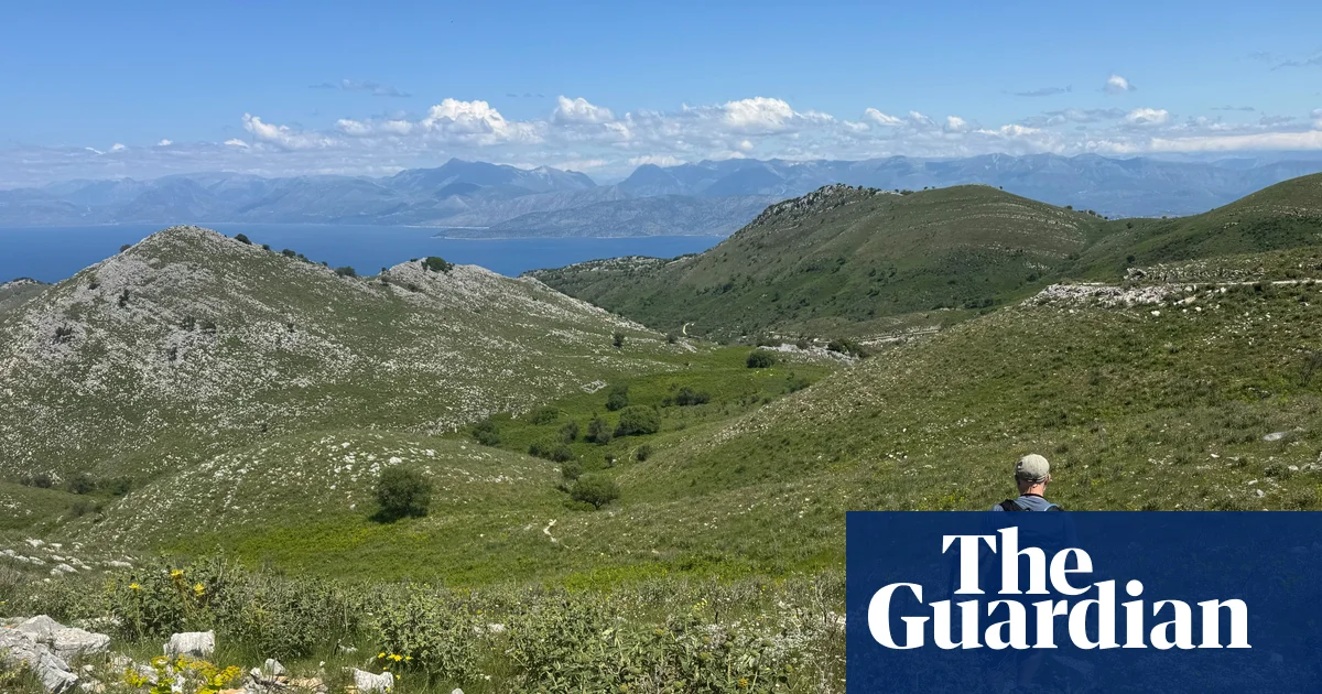
Cape Asprokavos in the far south of the island – close to the starting point for Sarah Baxter’s walk. Photograph: Sarah Baxter
That was 40 years ago. Corfu – the green queen of the Ionian Sea, Gerald Durrell’s “garden of the gods” – was already popular. In the intervening decades, development has been rampant and infrastructure, from roads to water supply, struggles to cope with the summer influx. But how about visiting off-season and off-piste? Winter can be tricky, with many places shut, so my husband and I had chosen to come in spring, exploring largely on foot, via the Corfu trail.
The sun was warm, the land now awake from hibernation as we set out on the 110-mile (180km) route that runs the length of the island, from Kavos to Agios Spyridon. Wriggling along the more rugged, less developed west coast, with deviations into the central hills and wide Ropa valley, it then traverses the mountainous north, always seeking the way less trodden. You could travel by (limited) buses or hire car, but doing some walking is the best way to happen upon Corfu’s offbeat bits.
We covered between 8 and 20 miles a day, though there’s no need to do all that – most walk it much more slowly. But, with our luggage being transported ahead each night to an array of simple pensions, family tavernas and beach hotels, our shoulders were light, so we were keen to roam as much as we could, following the yellow and black signs, arrows daubed on rocks and the GPS files on our phones – the route was largely well marked.
Every day, there were wonders to discover: wizened Mitéra, a 1,500-year-old olive tree near Prasoudi beach; a profusion of wildflowers, in all hues – rosy garlic, hot-purple rock roses, punchy yellow sage; a magical ancient footway between Makrata and Ano Garouna that had fallen out of use until the Corfu trail was blazed 25 years ago. The path traversed a cypress-pierced hillside before plunging into dark, forgotten olive groves that concealed what looked like the remains of a lost city, but was in fact natural rock cloaked in moss.
A few hours after these “ruins”, we arrived in Sinarades and found ourselves at the bottom of a flight of stone steps leading into the Folklore Museum. It couldn’t be open, could it? But yes, Makis beckoned us into this 19th-century farmhouse (entrance a modest €3), empty of visitors but full of the stuff of Corfiot village life: fine costumes, farming paraphernalia, fig cutters, cobblers’ tools.
Tools in the Folklore Museum, Sinarades. Photograph: Sarah Baxter
It was fascinating, getting these glimpses of old Corfu, invariably inland. In the northern mountain village of Sokraki, after the only downpour to spoil our sunny skies, we drank ginger beer at Emily’s cafe, still made the traditional way, using only water, lemon juice, sugar and ginger. Then we wove our way down the narrow streets to the Lithari Olive Oil Museum, where an old family press has been restored.
The following day, we visited Old Perithia, a 14th-century village tucked beneath Mount Pantokrator, the island’s highest point. Like many similar outposts, Perithia was abandoned in the 1960s; unlike many, it has been revived, and is now a lively, living cluster of homes, tavernas, honey shops and a characterful B&B. It was a hot day, so we flopped on to the shady terrace of O Foros cafe and lingered over fresh salad, homemade pie and tsigareli (garlicky wild greens), before descending to the coast via a long-lost path, only rediscovered during the Corfu trail’s creation.
Myrtiotissa beach is reached by a narrow path on the cliffs. Photograph: Constantinos Iliopoulos/Alamy
Despite being ravishingly clear and a respectable 16C (60F), there were very few swimmers in the sea. Such was the case at Myrtiotissa, halfway up the west coast – the spot where Odysseus allegedly washed ashore, and widely known as a nudist beach. A steep, skinny track leads to this cliff-backed sliver of sand, a real Instagrammer snarl-up in summer. But when we walked down, road and beach were deserted enough for us to throw off our inhibitions and clothes, and frisk Nereid-like in the waves.
If there’s one stretch of Corfu coast not to miss it’s Erimitis, the “hermit” peninsula at the island’s north-east. There used to be a naval observation post here, keeping an eye on Albania, about 2 miles away. As such, Erimitis escaped tourist development, leaving it the last stand of pristine Corfiot nature: no villas, no olives, just a scrub of oaks, myrtles and strawberry trees, brackish lagoons, butterflies and birds, herbs and wild orchids, plus rare monk seals and seagrass offshore.
But it’s under threat. In 2012, the government sold the rights to develop a portion of Erimitis to foreign investors. Organisations such as Save Erimitis and the Ionian Environment Foundation are fighting to conserve it.
Leaving the Corfu trail for the day, we picked up a footpath linking upmarket Agios Stefanos to the fishing harbour of Kassiopi, via Erimitis’s edges, a walk of about 5.5 miles. Immediately, there was a different feel here; it was a place without human touch, where the water seemed even clearer. We walked through fairytale tunnels of trees and detoured down a trail that ended at a bank, where a rope dangled down to a forest-backed beach. With no one about, it seemed silly to bother putting on swimmers, so we skinny-dipped again, now accustomed to the temperature, and warmed by the smugness of being here, now, alone. Right time, right place.
Dodgers fans generally hiss at the mention of Frank McCourt — the former owner took the team into bankruptcy, after all — but today is about tipping our cap to him.
Without him, fans would have no option to take public transit directly to Dodger Stadium. On his watch, the Dodgers helped secure government funding for the shuttle buses that provide free rides between Union Station and Dodger Stadium.
Sixteen years later, beyond the addition of a sister shuttle from the South Bay, that’s it.
The Dodgers boast the best team in the world. Shohei Ohtani is a tourist attraction. So is their historic ballpark. The Dodgers sold a record 4 million tickets last year.
In 1990, the last year Fernando Valenzuela pitched for the Dodgers, Los Angeles County unveiled a report that suggested ways to improve access to Dodger Stadium “for those who cannot or do not wish to drive.”
The options: a monorail, people mover, or light rail extension from the Chinatown Metro station; the shuttle buses that McCourt and Metro launched 20 years later; the gondola that McCourt first pitched in 2018 and continues to pursue; and a walking path.
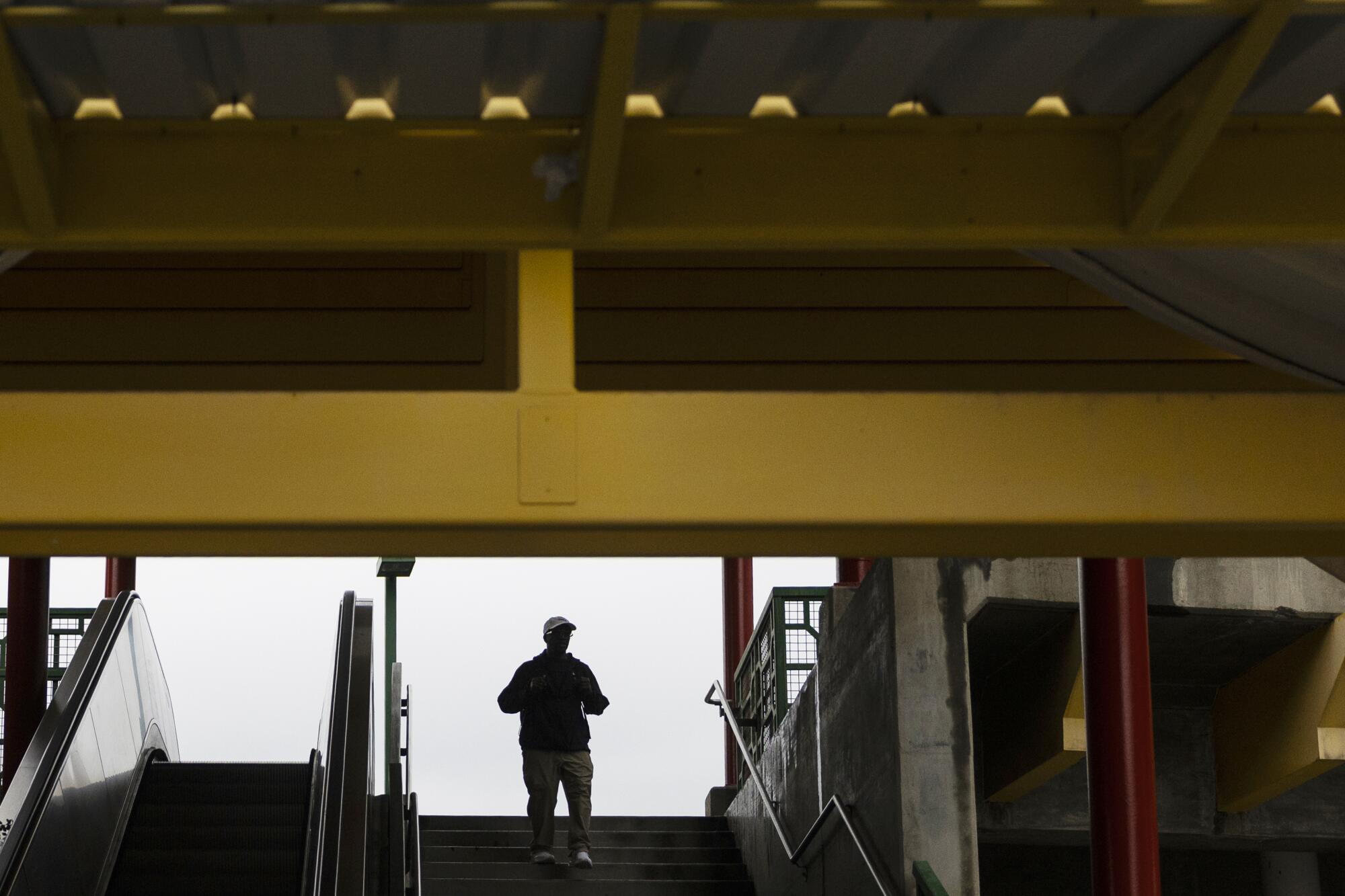
A passenger exits the Chinatown Metro station in January.
(Etienne Laurent/For The Times)
L.A. is all about the car. You will most likely drive to Dodger Stadium, and so will your children.
For decades, the Dodgers have promised to ease traffic by adding amenities that encourage fans to come early and stick around after the game. That has not materialized, and notorious congestion within and around the stadium is as much a tradition as Dodger Dogs.
What if you could walk, for real? What if you could head into the stadium along a beautifully landscaped and wide Dodgers-themed path, a blue ribbon of fans coalescing into a community, with decorations and food carts, shade and lighting, and chants of “Let’s Go Dodgers!” along the way?
You can walk now, sort of. It’s about a mile.
There’s a map at the Chinatown Metro station displaying the pedestrian path toward Dodger Stadium.
(Etienne Laurent/For The Times)
At one end of the Chinatown station, there is a map with a pedestrian route, in a glass case that faces away from Dodger Stadium. If you walk out of the station at the other end, or if you just start heading in the direction of Dodger Stadium, good luck finding the map.
There are Metro signs leading you back to the station from Dodger Stadium, but none leading you along the route there.
The Dodgers actually would prefer you did not take that route, or at least the last part of it. I walked it with Alissa Walker, whose Torched newsletter is the go-to place to learn how major sporting events impact the everyday lives of Angelenos.
We entered the Dodger Stadium property at an intersection with no crosswalks, where cars enter and exit the 110 freeway. We stood atop a dirt patch next to a crumbling curb.
“To go a very short distance safely with a feeling that you’re not going to die,” Walker said, “is very difficult.”
With Game 3 of the World Series underway at Dodger Stadium last October, a few folks scurried across a pedestrian bridge with LED lights and blue glow sticks.
The bridge connects Chinatown with Dodger Stadium, traversing the 110. Without this bridge, there is no walking path to Dodger Stadium.
“Our goal was, just by adding some lights, to make the really dark path at the top of the bridge at night a little bit brighter, so that it felt a little less scary,” transit advocate Jeremy Stutes said, “and to add a little bit of fun and whimsy.”
Glow sticks forming the “LA” logo of the Dodgers were placed on a pedestrian bridge over the 110 Freeway connecting Chinatown to the area where Dodger Stadium is located during the World Series and for several months after. As of last week, the glow sticks were no longer there.
(Etienne Laurent/For The Times)
From the Chinatown Metro station, the bridge is three blocks up College Street and one block down Yale Street. It’s an easy walk, and for now you pass an elementary school, a church, a row of Chinese restaurants, a dirt lot where a hospital once stood, parking lots, and an auto repair facility with a Dodgers flag hung on a wall.
When I did the walk last week, the trash at the foot of the bridge included a plastic cup, socks, a piece of rotting fruit, a half-full bottle of tequila, and half of a turkey sandwich, peeking out from torn plastic wrapping that indicated the sandwich had gone bad three days earlier. On the bridge: shopping bags, a pair of flip-flops, stray clothes scattered at one end, and graffiti everywhere.
A sign painted on the sidewalk indicates the direction toward the Chinatown Metro station.
(Etienne Laurent/For The Times)
That was the point those volunteers made last October: Clean up the bridge and light up the bridge — as they did for three days — and fans will walk there.
“It’s not that it’s not used,” Stutes said. “It’s not designed to be a safe space to use as an alternative to driving.”
When you cross the bridge, you can turn right or left along Stadium Way to get to a stadium entrance.
Turn right, as the map tells you to do, and you’ll encounter decaying sidewalks, with cracked and buckled concrete that turns a modest uphill walk into an obstacle course. Once you get onto the stadium grounds, the paint is fading along the pedestrian path, which offers you no protection from passing cars.
Turn left, and you’ll have to walk part of the way in the street, on an unprotected bike lane. You also could walk along the road behind the Fire Department training center, a path with no sidewalks and passing fire trucks. Either route takes longer than the one on the map, but you would enter Dodger Stadium through a pair of protected and brightly painted pedestrian paths. (That entrance, along Vin Scully Avenue, is a quarter-mile from Sunset Boulevard, where two Metro bus routes stop.)
If the primary choices for getting out of Dodger Stadium after a game are car congestion or Dodger Stadium Express shuttle bus congestion, a downhill walk to Chinatown Metro station — 12 minutes, Metro says — would be a nice option. That’s why those folks lit up the bridge over the freeway during the World Series.
“The lights were just a fun way,” transit advocate Kevin Dedicatoria said, “to show, ‘Hey, here’s a bridge so you don’t have to play, ‘Dude, where’s my car?’ or have to worry about waiting for the bus.’”
McCourt hails from Boston, where the local subway drops Red Sox fans a few short blocks from Fenway Park. When McCourt owned the Dodgers, I asked him if he could envision a subway or light rail extension to Dodger Stadium.
He’d love it, he said then, but the Dodgers were a private business, and government should pay for public transit.
Homes line a street in Eylsian Park, where Dodger Stadium is located.
(ETIENNE LAURENT/For The Times)
It was a fair point. The Dodgers pay taxes. In an era where teams regularly demand stadium and arena deals that exempt them from property tax, the Dodgers have paid $12.8 million in property taxes over the past three years, according to Los Angeles County tax collection records.
Would demand for public transit amid a car culture justify the investment? The Dodger Stadium Express indicates it could: Ridership has just about quadrupled since its inaugural season, from 122,273 in 2010 to 463,147 last year, according to Metro.
Even along the poorly maintained, poorly lit and poorly advertised pedestrian path, Metro said more than 700 riders returned to the Chinatown station on each of the three nights of World Series home games last year.
“As seen in social media videos during the 2025 postseason, the walking path continues to explode in popularity,” Metro spokesman Jose Ubaldo said.
Next steps?
“It’s astonishing to me that the Dodgers have not taken it upon themselves, as this great community partner, to fix this problem,” Walker said. “It is the city’s responsibility, but the Dodgers should be doing this, as part of what they want to represent to this community.”
The walking path includes segments along city streets, a Caltrans bridge, and Dodger Stadium property. Just who is the responsible party?
A Caltrans spokesman said the city is responsible for maintaining the bridge. A spokesman for the city’s department of street services did not provide an answer. A spokesman for the Dodgers declined to comment.
You could almost hear the sigh from city councilwoman Eunisses Hernandez, whose district includes Dodger Stadium.
“That’s what my job is: to bring people and agencies and organizations together to accomplish a goal,” Hernandez said. “We’re already in conversation with all these entities.
“We’re looking at some of the things we can enhance to make this a more walkable and accessible option for people.”
City Council member Eunisses Hernandez, center, talks with Circle outreach workers in Los Angeles.
(Allen J. Schaben/Los Angeles Times)
How much might those enhancements cost?
Without a look at a city-commissioned Dodger Stadium traffic mitigation study, expected to be completed this fall, Hernandez said she could not put a price tag on it.
“What I can tell you,” she said, “is that it will be less than half a billion dollars, for sure.”
By year’s end, the Los Angeles City Council is expected to vote on McCourt’s gondola project, estimated to cost $500 million and proposed as privately financed. Last November, the council voted 12-1 to urge Metro to kill the project.
Metro granted its approval, but with conditions that included a requirement to explore supplementing the gondola with other Dodger Stadium transit options, including more buses along Sunset Boulevard and a designated walkway from there to the stadium.
The walking path proposed in that 1990 study would have avoided Sunset Boulevard and the current Stadium Way routes — the ones with crumbling sidewalks, or no sidewalks at all — by using escalators and walkways to get fans up and down the hill between Lookout Drive, just off Stadium Way, and Dodger Stadium.
“Pedestrians could be directed through Chinatown,” the study read, “where numerous restaurants, shops and pedestrian amenities are provided.”
It’s hard to sell Chinatown businesses on the benefits of the gondola when fans would ride between Union Station and Dodger Stadium, soaring over Chinatown. It would be easier if a walking path led at least some of those fans through Chinatown, even if only on the way back from the game.
Even if the gondola system really can accomplish what its proponents say it can — loading 35 people into a cabin every 23 seconds — thousands of riders leaving when the game ends could mean a long line to board.
One of the entrances to Dodger Stadium on Stadium Way, the easiest access when walking from Chinatown Metro station.
(Etienne Laurent/For The Times)
“Also,” the 1990 study said, “passenger waiting following a game is psychologically perceived as being three to four times longer than actual waiting time.”
From this perspective, McCourt might win a few council votes by funding a first-class walking path. The cost, I’m told, would depend on what the enhancements include: signs, lights, trees, shade canopies, sidewalk repairs, escalators, and so on. For something close to $5 million — one one-hundredth of the projected cost of gondola construction — McCourt likely could do an exceptional job.
Is there any sign of progress here? Happily, yes.
In an internal report last December, Metro said Zero Emissions Transit (ZET) — the nonprofit organization now shepherding the gondola project — is pursuing ways to link pedestrians and bicyclists to the transit system and to Dodger Stadium. Those potential improvements include sidewalk repairs and a revitalized pedestrian pathway from the Chinatown Metro station to the bridge across the 110 and then across Stadium Way, to Lookout Drive and the hill above.
“Dodger Walk is envisioned as a series of switchbacks,” the report said, “inspired by the original walking path up Lookout Mountain that existed prior to the construction of Dodger Stadium.”
Whether such switchbacks would make the walk to the stadium longer or shorter than the current path remains to be determined.
In a statement, ZET said: “We embrace and include active transit solutions to increase pedestrian and bike access throughout the project area.” In particular, ZET said, it was “supportive” of a walking path to Dodger Stadium.
The Metro report cautioned the concepts “are in the early planning stage,” so L.A. might get an extravagant walking path, a utilitarian one, or none at all.
Here’s hoping McCourt gives us a path of some kind — whether the city approves the gondola or not — because a pretty walk generations can enjoy would be a prettier civic legacy than driving a team into bankruptcy.
There’s a massive hole in the ground at the top of Whinney Hill – a shale quarry that once supplied raw materials for Accrington’s famous Nori brickworks (as used in the Empire State Building and Blackpool Tower). It’s fitting, as there’s a chasm-wide gap in history when it comes to this unprepossessing spot on the edge of the West Pennine Moors.
On the morning of 24 April 1826, about 1,000 weavers met on the hilltop to plan their day and, no doubt, get the lie of the land and the weather before setting off. A banking crisis in December of the previous year – dubbed the Panic of 1825 by historians – had hammered the cotton industry. Lancashire’s weavers, who had already suffered years of declining wages and living standards, faced destitution and even starvation.
Desperate, they decided to carry out large-scale breakages of power looms to send a symbolic message to their employers and the government. On that fateful April day, the first of four days of action, they would split into groups to walk many miles to Clitheroe, Oswaldtwistle and Blackburn – mill towns where they were met by soldiers, cavalry and yeomanry with guns and swords. By the end of their protest marches, at least six people had lost their lives.
The views, once you get past the fencing around the old quarry, now a landfill, are extensive – especially on such a pin-sharp winter’s day as I had when I recced one of the weavers’ walks with local guide and historian Nick Burton, who is leading this year’s remembrance walks for the Weavers Uprising Bicentennial Committee (WUBC) charity. Eight guided walks, taking place across Lancashire between March and August, will follow the routes used by the 1826 protestors as closely as ipossible.
We could make out the moorlands around Darwen to the south, Burnley to the east and Pendle Hill in the north. Behind and below us was Accrington Stanley’s Wham Stadium, which has a terrace named after Whinney Hill.
We opted for the Clitheroe route, as it would take us near to home. Like the weavers, we began on the old turnpike road, now the A680, which is dotted with Victorian and earlier properties. I spotted several Mill Lanes, old access points to workplaces now turned into housing estates. There were also plenty of Moor Lanes. We passed through Clayton-le-Moors – best known for its fell running team, once presided over by the legendary Ron Hill – and Great Harwood, another textile hub, and birthplace of printing and dyeing innovator John Mercer.
James Spencer’s the Powerloom Riots in the Whitaker museum shows weavers smashing power looms in the Whitehead family’s mill in Rawtenstall. Photograph: The Whitaker
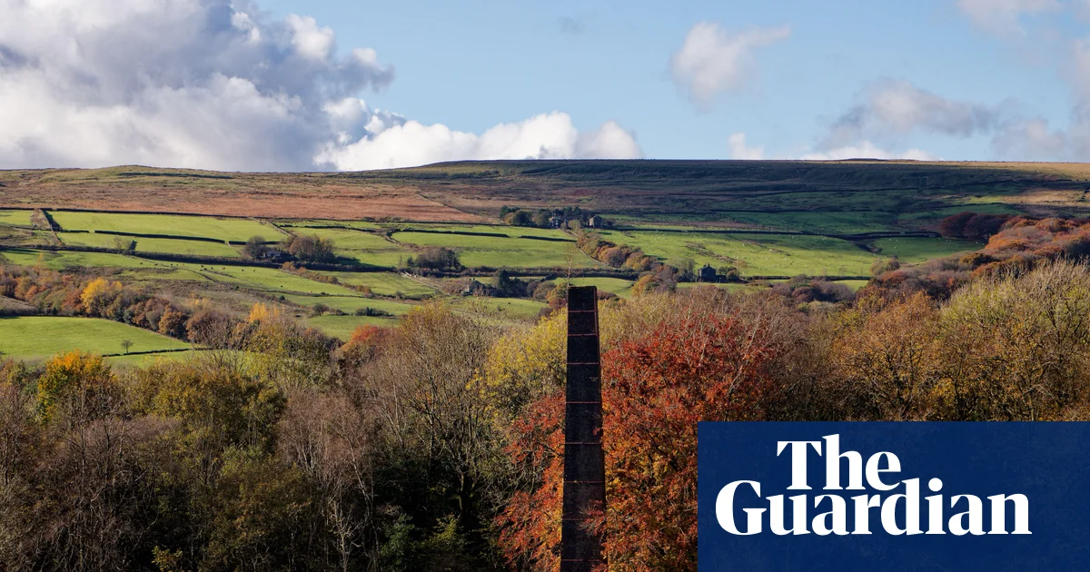
Things got greener around the Grade II-listed Martholme (former) railway viaduct, where we looked down on the River Calder. I was on familiar ground, having learned to drystone wall in the shadow of this 10-arched beauty. The Calder takes wild meanders here, as it approaches the River Ribble. We followed what was probably an old limers way (packhorse routes used by traders to carry lime) before climbing to a shoulder of the Nab, a prominent, wooded hill above Whalley, with its stirring Cistercian abbey ruins and Lancashire’s longest viaduct. With views all the way back to Whinney Hill and dramatic wintry shadows, it was time for tea and a butty. We were soon at the summit and with even bigger vistas north. As the sun crept away, it turned chilly. We more or less raced across the last few fields to get to Low Moor, where there was one final disappeared mill and clash between unarmed weavers and soldiers to note – whence to the New Inn in Clitheroe for a warming ale.
A total of 415 power looms were broken on the first day of the uprising. It wasn’t the first time workers had smashed technologies, many of which had been invented and developed in Lancashire. The spinning jenny was invented in Oswaldtwistle; Blackburn and Manchester were testbeds for the power loom. But the workers had been pushed to the limit; after tramping 10 miles or more, sometimes encountering resistance, they had to hike all the way home.
My second walk, a week later – on a colder, even crisper day – started and finished at blue plaque sites. It began in Haslingden, this time heading south. The first plaque, on the former New Inn, recorded that on 25 April 1826, handloom weavers were arrested for destroying 100 power looms in nearby Helmshore. They were charged with riot but released when an angry crowd protested. Some were transported to Australia for life. A bystander called Mary Hindle was sentenced to death, later commuted to transportation.
This route – taken by the weavers on the third day of the uprising – passed some pitstops for coffee and culture, including the Whitaker museum and art gallery, which has a social history collection featuring a painted panel capturing the moment handloom weavers smashed power looms in the Whitehead family’s mill in Rawtenstall. They destroyed 96 looms in just half an hour. A new commemorative WUBC banner, Rise Up!, by textile artist James Fox is on display. On 16 April, a newly commissioned sound and film installation by Blackburn-based artist Jamie Holman, responding to the original painting, will be unveiled.
The viaduct at Whalley, (known locally as Whalley Arches), from the grounds of Whalley Abbey. Photograph: Alamy
From the windows of the gallery you can see Hardman’s Mill, with its 49-metre (161 foot) high chimney, which postdates the uprising. Before it was bought by self-made textile magnate Richard Whitaker, the grand mansion containing the museum was the home of George Hardman. It’s said he liked to be able to see the mill from the windows.
The weavers took action at Hoyle and Ashworth’s Mill at New Hall Hey, and Longholme Mill – a site now occupied by an Asda. A lot of east Lancashire’s textile buildings have been razed, but you can see traces of foundations or old walls in some places, as well as repurposed mills used as offices or carpet shops. Wherever you see a big supermarket, it’s worth checking the old Ordnance Survey maps on the excellent National Library of Scotland website. There’s a good chance that a supermill once stood where now we buy groceries.
In the centre of Rawtenstall, we passed the famous Mr Fitzpatrick’s temperance bar (where I always take a pint of blood tonic) and a vintage chippy called Old Man Greenwood’s, which has been serving splits (chips and mushy peas) and babby’s yeds (steak and kidney pudding)since 1932 (it also sells fresh fish). After passing the terminus for the East Lancashire heritage railway, underneath the aforementioned chimney, and through a small industrial estate, we were on a path running along the side of the River Irwell (all the way to central Manchester if you’re so inclined). The busy A56 wasn’t far away, but it was peaceful and pastoral, with herons and mallards, and lots of songbirds; the all-day frost made the scene bewitching.
At the border with Greater Manchester, on Plunge Road, we went down into the woodland beside Dearden Brook. All that remained of the mill here were crumbling stone walls, draped, Angkor Wat-style, in a century of undergrowth. From Edenfield, we had distant views over the valley to Musbury Tor – a sort of miniature Pendle Hill, its pronounced profile standing out clearly amid the level moortops.
Valley of the Dearden Brook, Rossendale, Lancashire. Photograph: Martin Moss/Alamy
A hard-to-read small blue plaque on a house in Chatterton, bearing the specious title The Chatterton Fight, informs passersby that handloom weavers “were fired on by soldiers of the 60th Foot. Four men and one woman was killed. A fifth man, an onlooker, was also later shot dead.” The local magistrate, William Grant, had read the Riot Act, giving a green light to the violence. Soldiers fired 600 bullets into a crowd of 3,000 people over a period of 15 minutes. You can listen to actor Maxine Peake reading their names out loud here, on behalf of the WUBC.
Lancashire historians believe the significance of the April 1826 rising, and the Chatterton Massacre, have been unjustly overlooked. But the events of those four days – brave and tragic – are a historical bridge between the Luddite risings, Peterloo and Chartism. In the heartfelt words of Dr David Gordon Scott, founder and chair of the WUBC – who began organising remembrance walks in 2022 – “walking in the protesters’ footsteps and feeling the solidarity that arises by participating in their journey, deepens our understandings and sense of empathy with those courageous souls who 200 years ago risked their lives in a desperate attempt to ensure that their loved ones had enough to sustain them in the bleakest of times”.
See weavers-uprising.org.uk for more information on the history of the Weavers’ Uprising, plus dates and booking information for the guided walks
Chris Moss is the author of Lancashire: Exploring the Historic County that Made the Modern World, published by Old Street Publishing (£25). To support the Guardian order your copy at guardianbookshop.com. Delivery charges may apply
The waymarked quartzite path glimmers in the sun, flanked by amber-gold grassland. Beyond, one of Scotland’s finest landscapes opens up before me, a woodland of ancient Caledonian pines leading my eye to the metallic glint of Loch Maree. On the other side of the water, a winding river separates the steep, stacked rocks of Beinn a’Mhùinidh from Slioch, one of the great mountains of Wester Ross, rising to a knuckle ridge of Torridonian sandstone.
I’m walking the four-mile mountain trail looping through Beinn Eighe national nature reserve (NNR), Britain’s first NNR, which celebrates its 75th anniversary this year. In a crowded list, you’d be hard pushed to find a more soul-stirring landscape in all of Scotland.
“The mountain path gives you a real flavour for Beinn Eighe,” the reserve manager, Doug Bartholomew, told me earlier. “It takes you right through the heart of the ancient Caledonian pinewood, then you climb steeply up to this rocky upland with views of Beinn Eighe mountain itself.”
When I reach the high point, at about 550m (1,805ft), I’m awed by the views across a lonely valley to the jagged ridgeline of mountain, which surges and falls like Atlantic waves locked in stone.
Beinn Eighe NNR stretches 48 sq km from Loch Maree to the eponymous mountain summit. When it was created in 1951, a key mission of the NNR was to protect Coille na Glas Leitir (the Wood of the Grey Slope), which is the largest remaining fragment of ancient Caledonian pinewood in north-west Scotland. The woodland was felled by some of Scotland’s earliest ironworks in the 1600s, and forestry and farming took its toll over the generations, but it is believed to have been here for the last 8,000 years.
After the Highland clearances, the lower slopes of Beinn Eighe were increasingly used for grazing. Deer-stalking, grouse-shooting and muirburn (when old growth is burnt off to encourage new growth for grazing) followed. The final exploitation happened during the second world war, when lumberjacks were brought in from Newfoundland and British Honduras to fell the trees for ammunition boxes. But thanks to pioneering landscape restoration work, namely deer management and tree planting, woodland cover has increased by more than 40% in the 75 years since the reserve was created.
Today, it’s a rare Scottish landscape where you can walk beneath twisted and gnarled pine branches hundreds of years old, but also alongside younger, conical trees.
Stuart Kenny in the ancient pinewoods on the mountain trail. Photograph: Isabelle Erbacher
“In the past, we had a tree nursery; so we collected seeds from the reserve, grew them in our nursery and planted them,” said Bartholomew. “We’ve now got continuous woodland linked from Glas Leitir all the way through to Coulin Estate, where you’ve got other remnants of ancient woodland, and we’re moving more to natural processes – conditions that will allow the woodland to regenerate and expand naturally.”
I soon descend into Coille na Glas Leitir on the mountain trail, passing a mosaic of birch and pines, draped in lichen. This path was a public access landmark when it opened in the early 70s, encouraging visitors to explore the mountain, and it’s still perfectly marked (though snowfall can obscure it in winter). Stags roar from the other side of Loch Maree as I walk. Tougher to pick out are the crossbills, with crossed mandibles to prise open pine cones. In warmer months, dragonflies with magical names – northern emerald, azure hawker – nose around rare mosses.
While steep, the mountain trail isn’t technical. Along with the easier woodland path, which showcases the ancient forest, and short loops from the excellent visitor centre, the beauty of this reserve really is accessible. Local providers such as Shieldaig Outdoor Adventures also offer days out exploring the islands of Loch Maree by canoe or kayak in warmer months.
I’m staying in Torridon youth hostel, at the head of Upper Loch Torridon, south-west of the Beinn Eighe massif. It’s a 20-minute drive from Coille na Glas Leitir via the village Kinlochewe, passing beneath the bulky mass of Beinn Eighe before Liathach, an icon of Glen Torridon, is revealed. The hostel is tucked beneath this mighty mountain, not in the nature reserve itself, but in an ideal place to explore it and the Torridon hills beyond.
The view from Torridon youth hostel. Photograph: Stuart Kenny
“When we mention that we live in Torridon, people get misty eyes,” jokes Debbie Maskill, manager of the youth hostel. “For us, it’s the best part of Scotland. A real jewel.” It’s true that few place names roll so sweetly off the tongue of a hillwalker as Torridon. This is a place of grandeur – of immense, intimidating mountains set on some of the oldest rocks in Britain; of shifting light and uncompromising ferocity – with a beauty verging on myth.
The hostel – which itself turned 50 last year – is a pilgrimage site for hikers; it’s in close reach of some of Scotland’s finest scrambles, as well as the family-friendly nature reserve. Walkers and climbers trade stories and photographs in the communal kitchen and dining area. Floor-to-ceiling windows in the cosy lounge allow you to watch the weather roll over the Wester Ross peaks.
I stay in a comfy private room, and regret my early bedtime when a French guest shows me the photographs he took of the aurora shimmering above Loch Torridon the next morning. “Winter really captures the far north essence here, but by February, it’s getting lighter,” says Paul Thompson, duty supervisor at the hostel. “In the middle of winter, we don’t see the sun here, but in February it’s above the hills for quite some time. Then you get to May, a stunning time of year, when everything is fresh and you’ve got almost endless daylight. I love it all.”
Loch Maree seen from Beinn Eighe. Photograph: Stuart Kenny
On a six-mile loop of Loch Clair and Loch Coulin, just outside the reserve, I stroll beneath more tall pines, looking on to the Torridon beasts. The grey, dotted ridge of Beinn Eighe looks like it has a snow leopard’s coat draped over it, and the pyramidal mass of Liathach reflects back off the water.
I plan to walk to the Triple Buttress of Coire Mhic Fhearchair on my final day (three glacial rock towers in a corrie of Beinn Eighe), but heavy rain arrives. It’s all the excuse I need for a venison lunch at Bo & Muc, a field-to-fork restaurant at the swanky five-star The Torridon hotel.
I leave Torridon via the road to Achnasheen, stopping at the Glen Docherty viewpoint for one last look over the road to Kinlochewe, the lapping mountains and Loch Maree.
After centuries of deterioration, it’s heartwarming to see the fragments of ancient pinewood reconnecting here, in this immediately spellbinding landscape. In another 75 years, the young pines of Beinn Eighe will stand taller and, if all goes to plan, those who pass by them will be walking through a fully regenerative forest.
Accommodation was provided byHostelling Scotland. Torridon youth hostel has private rooms for two from £52 a night, dorm beds from £20.50. The Beinn Eighe NNR trails are open year-round and are free to visit. The Beinn Eighe NNR visitor centre (with info on the reserve) is open April to October, 10am to 5pm
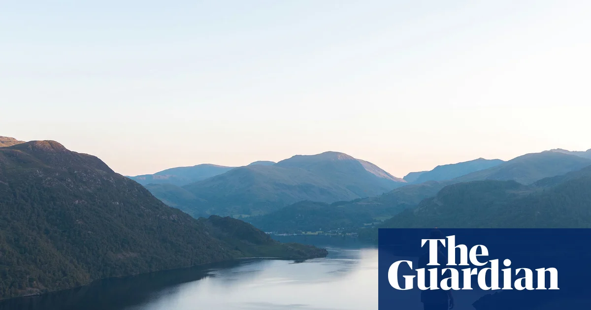
Before we enter the clouds on snow-capped Helvellyn, I glance back down at Ullswater. The early morning sun is bursting around the dark corners of High Dodd and Sleet Fell, sending a flush of light across the golden bracken and on to the hammered silver of the lake.
Further away to the south, ragged patches of snow cling to the high gullies. The nearest village, Glenridding, can barely be seen behind the leafless trees and all I can hear is the gurgle of the stream. It is the quintessential Lakeland scene: the steep slopes above the water, the soft colours and hard rock, all combining into something inimitable. And judging by the photographic and artistic record, it is one that has hardly changed since the Cumbrian wind first ruffled a Romantic poet’s curls.
Our best loved national parks – the Lake District, Peak District, Eryri (Snowdonia) and Dartmoor – all officially opened 75 years ago, in 1951. It was the result of a long campaign, arguably begun by one of those Romantics, William Wordsworth, a poet whose particular love for the Lakes led him to observe that the area should be “a sort of national property, in which every man has a right and an interest who has an eye to perceive and a heart to enjoy”. The resident of Dove Cottage at Grasmere fought, successfully, against railway building, noting the stupidity of destroying something precious in the pretence of increasing its influence.
That niggling dilemma has dogged the national parks ever since, but if Wordsworth were here now, I think he might approve, at least at first glance. The fate of some Alpine beauty spots has been avoided: no high-rise buildings break through the trees, no sports infrastructure litters the summits, and engineers have not blasted tunnels for bigger, faster, road and rail connections.
The planning process is tortuous, and woe betide anyone who likes a colour not in the Farrow & Ball catalogue, but our national parks survive, without sacrificing too much of their original charm.
Back in the 1970s my dad began taking me on his hiking trips. In those days, I didn’t share his excitement at “the views”, but I instantly grasped the magic of swimming under waterfalls, scrambling along ridges and sitting on mountain tops to eat hard-boiled eggs dipped in salt. He took us to all the national parks, and introduced us to their highlights. It was the start of a lifetime of exploration.
Dartmoor
Hiking through mossy Lydford Gorge on Dartmoor, in Devon. Photograph: Jack Jango/Alamy
The only area in England and Wales that has legal wild camping, Dartmoor is also the most threatened. A recent report detailed the sorry decline in biodiversity on its sites of special scientific interest (SSSI), but the truth is it remains in a better state than many other places. What makes Dartmoor special is the sheer extent of heathland: over 11,000 hectares of heather, gorse, bilberry and moor grasses, inhabited by birds, lizards, snakes and some rare butterflies. The top bird here is the red grouse, recently recognised as a distinct species, making it only the second reliably identifiable endemic British bird species.
Dartmoor’s reputation for other, more controversial species, is firmly established. On my first visit as a boy, I was reading The Hound of the Baskervilles and also glued to reports of escaped large cats. When we hiked past the infamous prison, and dad told us about “the Mad Axeman” inside, Dartmoor was firmly established in my head as the single most exciting area of Britain. I’ve never had reason to change that view.
Arguably the most evocative place is Wistman’s Wood, which is accessed from Two Bridges hotel, but popularity tends to destroy mystery and this is now an Instagrammed honeypot. Other excellent woodlands can be found down the Lydford Gorge near Tavistock or the Bovey Valley near Lustleigh, a village of thatched roofs where a cream tea is the acme of snackery. Try the Primrose Tearooms.
Nearby is Haytor Rocks, a magnet for climbers, and everyone else. It’s beautiful but popular. For tranquillity, try the military firing ranges: there’s nothing like an M115 Howitzer to deter most hikers, or perhaps it’s simply the need to check live firing times. It does seem to put visitors off, and there are wonderful viewpoints to be found, such as Yes Tor and High Willhays.
Eryri
Scrambling above Cwm Idwal in Eryri, where the renowned ‘staircase’ begins. Photograph: Andy Teasdale/Alamy
In Eryri, the hunt for peace and tranquillity has one rule: avoid Yr Wyddfa (Snowdon). Any other peak will be quiet in comparison. If you must go up Wales’s highest mountain, I suggest taking a less-frequented path, like the Watkin or Rhyd Ddu and go early – and I mean headtorch early. Another good option is the Ranger Path (Cwellyn), where the wind blew me off my feet as a nine-year-old. You might escape the crowds, but you can’t escape the weather.
Yr Wyddfa’s Crib Goch, one of Britain’s greatest ridge scrambles, can be a bit of a trial when oversubscribed, but there are many fine alternatives. Try Crib Lem on Carnedd Dafydd, accessible from Bethesda, or the Idwal Staircase, a tougher challenge that some might prefer to do roped up. Steve Ashton’s book Scrambles in Snowdonia is the essential guide.
One feature I love about Eryri is the way its industrial heritage has been repurposed to contemporary needs: the various slate mine attractions and the steam railways go from strength to strength. Bala Lake Railway has started work on extending its line into Bala town, a significant addition.
Lake District
The Lake District village of Grasmere, home of the Romantic poet William Wordsworth. Photograph: Andrew Roland/Alamy
The opening of the first parks triggered a wave of interest in hiking and a demand for route information. Like many others, my dad discovered Alfred Wainwright, whose hand-drawn pictorial guides are still a good way to find routes. Wainwright’s own favourite was Haystacks Fell, with an ascent from Buttermere via Scarth Gap. My own initiation into the joys of scrambling started with Wainwright routes up Lord’s Rake on Scafell Pike and Jack’s Rake on Pavey Ark, both serious undertakings.
Scrambling and its sister sports, fell-running and scree-racing, have a proud history in Lakeland. Over in Wasdale, sheep farmer Joss Naylor was an inspiration. As a teenager, I witnessed his hell-for-leather approach to scree slopes, transforming them from places to be avoided into a new challenge.
Wasdale, with its historic inn, remains a favourite. If the trail to Scafell Pike is often busy, look out for classic treks like the Mosedale Horseshoe, taking in Pillar, a stiff challenge when torn shreds of cloud are whistling around your ears. For the sure-footed, the climbers’ trail passing beneath Napes Needle is another gem. The Needle is a satisfying climb with historic importance. Photos of early pioneers the Abraham brothers, standing on top in their 1890s hobnail boots, fuelled interest in the new sport of rock climbing.
Across to the east, the 17½-mile trek from Pooley Bridge to Troutbeck over High Street is an absolute gem, with sustained panoramas on a clear day. Another classic is theKentmere Round, which normally starts at St Cuthbert’s church, near Staveley. For sheer delight in Cumbrian topographical names, the Kentmere Round is a must: Yoke Fell is followed by Wander Scar, Toadhowe Well and Shipman Knotts, among others. The best advice is to find a fell with an unfamiliar name, get the OS map and devise a route. Asking a local also usually pays off.
After an epic day of snow and ice on Helvellyn, I take my own advice. I am staying at Another Place hotel along the Ullswater north shore. The lakeside panorama tells the tale of changing times: there are paddleboards and kayaks on the water; groups heading off on wild swims; and a mobile sauna by the shore. Hotel director and local man David Vaughan tips me off about a favourite walk, on nearby Gowbarrow Fell.
The path starts at Aira Force waterfall, a well-known attraction, and the car park is busy. Beyond the falls, however, things are quieter. At 481 metres, the Gowbarrow summit is not high, but the panorama is superb. Further on comes the real climax: a balcony walk around the contours and above the lake.
A kestrel swoops past, close enough to see the wind ruffle its chestnut feathers. At the end, the path drops down to the woods and there’s a young woman, hesitating. Her kit looks fresh from the packet.
“Is there any scrambling up there?” she asks nervously.
“No,” I say, noticing her immaculate nails. “But there’s lots of mud.”
She takes a deep breath and grins. “OK.” Then sets off. Joss Naylor, my dad and the Romantic poets would all be proud. Our parks are still doing their best for us.
The Peak District National Park is one of the most beautiful areas Britain has to offer, and this town, paired with this tour, gives you the ultimate experience of it
‘I had the ultimate Peak District experience – with all the views and none of the walking’
The Peak District National Park in Derbyshire is a sight to behold, but with over 300,000 acres worth of land and some pretty sheer climbs, it can be overwhelming to know where to start. If caught by such doubt, there’s only one real answer.
One of the best ways to see the heights of the peaks and immerse yourself in their splendour is to ditch the hiking boots altogether. And the best place to begin, I’d argue, is at the very top, in Buxton – England’s highest market town.
When staying at The Buxton Crescent Hotel, the real heart of the town and a hub for a truly tranquil escape to Derbyshire, you can be assured that there’s a fantastic range of trails on your doorstep. There are a number of routes to take, so I hopped on a bike courtesy of PeakePedals and cycled out.
Best Derbyshire holiday cottage deals
This article contains affiliate links, we will receive a commission on any sales we generate from it. Learn more
Derbyshire is known for its dramatic Peak District landscapes, historic market towns and stately country houses. Sykes Cottages has hundreds of places to stay, with prices from £32 per night.
Bike Tours
Specifically designed for guests staying at the hotel and catering for those travelling in at Buxton Station is White Peak Adventure. This is a route created by the cycling experts at PeakePedals to help visitors experience the villages, valleys and hills of the White Peak, just south of Buxton.
Many guests opt to hire their e-bikes and a Garmin GPX navigation device with their chosen route pre-programmed. This means they can have their own day out, with clear directions, and none of the fuss.
However, we were lucky to have a tour guide in Dan, a team member and local expert, who took us through the winding roads and hills, pointing out the areas of interest along the way.
Touring on a bike means you can see a hell of a lot more of the Peaks than you naturally would on foot. We ended up going over 20 miles around the national park, winding through villages and along pretty country roads. This is perfect for someone who only has a day or a short weekend to explore and is keen to make the most out of that time – with all the views and none of the blisters.
Passing through the stunning ‘Dragon’s Back’ limestone reef was a true highlight of the ride for me, and having previously climbed it, I can assure you it was far less difficult and even more beautiful from below. The bike certainly offered a fresh perspective on the Peaks.
We stopped and gawped periodically, while our guide recommended pubs, cafés or the best villages we might want to spend a moment in. But Dan was happy to take our lead, as he would remind us: “It’s your day.” We opted for two stops, one in Longnor and the other in Hartington – two quintessentially English villages.
As a big coffee lover, this was ideal, as I can never get enough of stumbling upon a cosy coffee spot and sampling some homemade bakes. Of course, here in Buxton, the local delicacy is the Bakewell Tart, which is a must-try when in the Derbyshire area.
As charming a day as it was, it being Britain and March, cold and thick fog descended, obscuring the beauty of the hills a little.
Of course, it’s hard to come to the Peaks and not take on somewhat of a hike, and for a short hike with ease near Buxton, Lud’s Church is the perfect choice. Sitting less than a 20-minute drive outside of the town, it’s a popular route, proven by the groups of walkers we saw heading that way.
The terrain is easy, and the route isn’t steep. The hidden paradise that you reach is certainly a treat.
Beginning at The Roaches Gradbach Car Park, we were able to park up and begin the walk, following the signposts along the way. It took us past the scout camp, down a rocky path alongside farmers’ fields, before reaching a tranquil little bridge.
As you walk, you wind through forests and find yourself at the mysterious gorge, illuminated by green moss. When I stepped down into the chasm, I felt as though I’d stumbled across a hidden gem, like something out of Jurassic Park or Jumanji, with tropical-looking plants growing in between rocks, covered in layers of the brightest green moss.
Once you reach the other side of it, climbing out of the gorge, it’s mostly flat, and we had a carefree walk through the trees, slowly making our way back down in a circular route, back to the car. All in all, the walk typically takes two hours, but we were able to complete it in an hour and a half, driven on as we were by a desire to eat lunch.
Book it
Emily stayed at Champneys Buxton Crescent Hotel & Wellness Spa start from £185 including bed and breakfast. For general hotel bookings, please visit: buxtoncrescent.com and contact Email: info@buxtoncrescent.com Tel: +44 1298 808 999
A London beauty spot is being praised as ‘pretty’ and ‘stunning’ while drawing comparisons to Japan thanks to the abundance of cherry blossom trees that are starting to bloom there
Jess Flaherty Senior News Reporter
15:59, 16 Mar 2026Updated 15:59, 16 Mar 2026
People hoping to see an abundance of cherry blossom trees in the UK are in luck (stock image)(Image: serts via Getty Images)
A “stunning” beauty spot has been branded “special” and “pretty” for offering visitors a taste of Japan, all without leaving the UK.
With spring now in full swing, countless nature enthusiasts are eager to embrace the kaleidoscope of colours emerging as flora and fauna transform with the changing seasons. The bare branches and dormant plants of winter are quickly changing and bursting into bloom.
Cherry blossoms are a highly sought-after sight, strongly linked with regions of Japan. Referred to as Sakura in the East Asian country, blossom trees are the most widespread tree throughout the country, with many tourists timing their Japanese holidays around the cherry blossom forecast.
However, those unable to jet off across the globe in pursuit of picturesque pink petals are in luck, as one corner of London features an impressive display of cherry blossom trees.
Rita Farhi, a digital content creator who focuses on “noticing quiet magic in everyday life” in “London and beyond”, shared a video on Instagram showcasing a “hidden cherry blossom spot” in leafy northwest London.
In the caption alongside the footage, Rita wrote: “London has a few hidden cherry blossom spots… and this little path near Swiss Cottage is one of the prettiest.
“For a few weeks every spring it turns completely pink and feels like walking through Japan. It’s already starting to bloom this year. If you love cherry blossom walks, this one is worth saving for the next sunny afternoon.”
She added: “Have you seen it yet? Swiss Cottage, London. Spring in London never stays long… which makes these little moments feel even more special.”
Content cannot be displayed without consent
In the comments section, Rita provided further detail about her video and explained: “Filmed a few springs ago. The blossoms often start pink and turn paler as they open.”
Felloe social media users were quick to share their thoughts. One person commented: “So pretty”.
Another wrote: “What a beaut!” A third said: “So beautiful” while a fourth agreed: “Stunning”.
Someone else enquired: “This is so beautiful! Thank you for sharing. Where in Swiss Cottage is this?”
Rita replied: “Very close to the tube station”.
Another Instagram user shared: “I saw it yesterday and it’s so beautiful”. While another added: “How beautiful! Love this area”.
For those hoping to spot cherry blossoms across the UK, the Natural History Museum explains: “Most of the common cherry trees planted in the UK blossom in April. Mild winters can result in the trees flowering earlier, sometimes in March, but in cooler years they might not do so until May.
“In London, and other particularly warm and sheltered locations, cherry trees can sometimes burst into flower as early as February.”