Towsley Canyon in Newhall has shade, wildflowers and a seasonal creek
I heard the ribbit of a Pacific chorus frog and couldn’t stop my feet as they veered me off the official trail and onto a foot path leading down to Wiley Creek.
I grew up with a pond in the pasture behind my house where I could listen to the riotous sound of amphibians any evening I wanted. The soundscape of freshwater habitats is such a comfort to me.
I sat down on a boulder near the water, trying to remain still. The frog had quieted after spotting me, and I hoped it would restart its song, understanding I was not a threat but instead just a big fan.
This was the first of many beautiful moments I experienced on my recent hike through Ed Davis Park in Towsley Canyon in Newhall. It features shady canyons with blooming wildflowers and wildlife that appear to be thriving. I would later learn that a walk through Towsley Canyon is also a journey through the history of environmental activism in the Santa Clarita Valley. This area was once slated to become a landfill.
Today, hikers can explore the area by visiting Ed Davis Park in Towsley Canyon, one of four recreation areas that make up the 4,000-acre Santa Clarita Woodlands Park. (The other three are East and Rice canyons, Pico Canyon and Mentryville, each of which are also worth exploring.)
And because I got confused by this, I will point out: The Rivendale Park and Open Space is also nearby, at the mouth of Towsley Canyon near the northeast corner of Ed Davis Park. So you could find yourself hiking along one of its trails as well.
Ed Davis Park offers access to multiple trails, including:

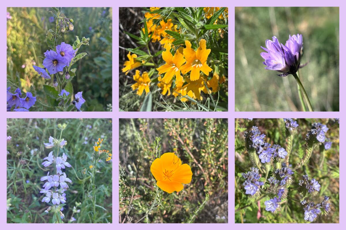
Clockwise, southern bush monkeyflower, blue dicks, phacelia, California poppy, a flower and purple nightshade that appears to be a collinsia heterophylla.
(Jaclyn Cosgrove / Los Angeles Times)
I arrived at Ed Davis Park just after 9 a.m. last week with a plan to take a short hike, given the high temperatures forecast that day. I parked near the entrance in the large dirt free lot. Note: There were no restrooms or portable toilets that this outdoors reporter could find anywhere nearby, so plan accordingly.
From the parking lot, I headed west, quickly turning south onto Wiley Canyon Trail. I was immediately greeted by a lesser goldfinch, perched on a strand of wild rye like a feathered park ranger.
The trail was initially a bit rutted but quickly smoothed out. As I headed into Wiley Canyon, I found myself in a crisp cool landscape shaded by large oak and California black walnut trees. I quickly heard running water. When I checked the thermometer hanging on my backpack, it read 69 degrees.

Clockwise, lesser goldfinch, western whiptail, convergent lady beetle and a lizard.
(Jaclyn Cosgrove / Los Angeles Times)
Although I could hear nearby traffic and a Southwest plane passing overhead, it didn’t block out the dynamic soundtrack of the canyon’s avian residents: the oak titmouse, northern mockingbird, blue-gray gnatcatcher and Hutton’s vireo, which, according to my birding app, were all above and around me.
As you travel along the canyon, you’ll find purple sage bursting out of the ground, and blue dicks starting to bloom. I passed by several ceanothus with white and blue-violet blooms. I really took my time taking in the native plant landscape and was lucky to spot a convergent lady beetle sipping on dew on a blade of grass.
After my short visit to the creek to find frogs, I was looking up to observe a turkey vulture and red-tail hawk circling overhead, seemingly competing for airspace, when I noticed the California dodder nourishing itself atop several plants on the hillside. Although it is a parasitic vine, this orange otherworldly being does indeed serve an important ecological purpose.

California dodder in the Towsley Canyon area around Newhall.
(Jaclyn Cosgrove / Los Angeles Times)
“Dodder will flower during the hot summer months, providing native insects with a valuable meal and drink during the months when many other California native plants are dormant,” Jorge Ochoa, an associate professor of horticulture at Long Beach City College, wrote for the Friends of Griffith Park regarding the plant’s purpose.
I continued south, passing a spotted towhee digging in the dirt for its breakfast. Then, just under half a mile in, I turned northwest onto the Don Mullally Trail. The trail is named after a naturalist who, according to park signage, “traversed every canyon, led countless hikes to unforgettable destinations, and shared the Woodlands’ unparalleled native tree associations and ecological majesty.” May we all be so lucky!

A shady portion of a trail in the Towsley Canyon area around Newhall.
(Jaclyn Cosgrove / Los Angeles Times)
This is where you’ll start to gain some elevation — and sun exposure. But it’s also where you will find the most blooming wildflowers! I quickly spotted phacelia with bright purple blooms, and as I headed west, an increasing number of California poppies and southern bush monkeyflower.

Towsley Peak near Towsley Canyon in Newhall.
(Jaclyn Cosgrove / Los Angeles Times)
Ed Davis Park is home to a robust butterfly population. I found a kaleidoscope of pollinators among the wildflowers and weeds, including a checkered white butterfly who was eagerly drinking from invasive mustard. I chuckled to myself. It didn’t seem to mind feasting on one of the most hated plants in Southern California.
The trail does turn into a narrow single track with thick vegetation, so please take good care as you’re hiking. I was very aware of the likelihood that I would encounter a rattlesnake, and I made sure to stomp my feet and pause from gaping at the flowers to make sure I wasn’t about to step on anyone. Additionally, watch out for poison oak, which I found growing among California black walnut.

Purple sage grows thick along the trails in Towsley and Wiley canyons. You might also spot an outdoors journalist who doesn’t realize their shadow is in the photograph until they get home.
(Jaclyn Cosgrove / Los Angeles Times)
Just over a mile in, I paused to take in the view. Several peaks in the Sierra Pelona Mountains, including Liebre Mountain, Burnt Peak and Jupiter Mountain, were easy to see from the trail, even though they’re about 20 to 25 miles away. I didn’t spend too long there, though, as my thermometer informed me it was 93 degrees in the direct sun. Where did spring go?
I took the Don Mullally Trail down and then the paved Towsley Canyon Road back to where I parked. You’ll notice as you head back that there are at least two paid lots should the free lot be full. You’ll need $7 in cash or a check, which you can deposit in the iron ranger.

The Sierra Pelona Mountains are visible from Towsley Canyon.
(Jaclyn Cosgrove / Los Angeles Times)

A turkey vulture flies low in Towsley Canyon.
(Jaclyn Cosgrove / Los Angeles Times)
Given its astounding beauty, it’s hard to comprehend how this parkland almost became a dump. But around 1989, an intense battle broke out between the Los Angeles County Sanitation Districts, which, at the time, managed wastewater and trash for 78 cities in L.A. County, and the Santa Monica Mountains Conservancy.
In early 1991, the Santa Monica Mountains Conservancy acquired 453 acres of Towsley Canyon, strategically buying a 180-acre parcel at the eastern entrance of the canyon and a 273-acre piece in the heart of it, according to The Times’ archive.
County officials mulled over whether they could still build a smaller dump in Towsley Canyon, but there was a major hiccup. The conservancy’s land was directly across the only two roads into the area, meaning the agency could hinder garbage trucks from using the roads.
“For all practical purposes, the coffin has been nailed on the proposal to turn Towsley Canyon into a landfill,” Joseph T. Edmiston, the conservancy’s executive director, said in a 1991 news article.
At the time, county officials were also considering building a dump at Elsmere Canyon — an effort also successfully fought off by local advocates.
Reflecting on my visit to Towsley and Wiley canyons, I thought about how our trash does indeed end up in someone’s neighborhood, whether that be a canyon wren, a jellyfish or your neighbor in another neighborhood (if we think about humanity and neighbors in a global sense). It’s a further incentive to practice the five Rs: refuse, reduce, reuse, recycle and rot.
I hope your journey through these canyons brings you a similar experience of joy, wonder and deep reflection!

3 things to do

An Egyptian goose in the Sepulveda Basin Wildlife Refuge.
(Amanda Thompson)
1. Better your birding in Pasadena
The Sierra Club Angeles Chapter’s Pasadena group will host “Photographing the Sepulveda Basin Wildlife Reserve” from 7 to 9:30 p.m. Wednesday at Pacific Oaks College. Guests will hear from photographer and storyteller Amanda Thompson and visual communicator Joe Doherty about how to better navigate the Sepulveda Basin to observe the flora and fauna that lives there. RSVP at act.sierraclub.org.
2. Cycle on over to Cudahy
Nature for All, an L.A. climate justice nonprofit, will host an 8-mile bike ride from 9:30 a.m. to 1 p.m. Saturday starting at Hollydale Regional Park in South Gate. Riders will peddle along the L.A. River before arriving at Cudahy River Park. Participants can reserve a bike by emailing Priscila Papias at priscila@lanatureforall.com. Register at cosechasoftware.com.
3. Frolic under a full moon in L.A.
We Explore Earth will host a free full-moon gathering from 5:30 to 8:30 p.m. Wednesday at Elysian Park. Participants will come together for a guided group hike cleanup followed by a sound bath and live music, all under the rising full moon. Register at eventbrite.com.

The must-read

Manatees rest at Blue Spring State Park in Orange City, Fla.
(Explore.org)
As I glided my kayak along the aptly named Crystal River in late March 2019, I couldn’t believe just how close the 1,000-pound manatees came to me and my friends. Nearby, my best friend Jenny squealed as a massive sea cow poked its whiskered snout out of the water next to her kayak. Whenever I’m stuck working indoors, I often turn on the live feed of the manatees at Explore.org. Apparently I’m very much not alone! Times staff writer Lila Seidman wrote that the number of nature-themed 24/7 livestreams created per year swelled by about 3,000% between 2019 and 2025. This genre of entertainment has been dubbed “Slow TV,” as it’s unedited and can be quite calming (although there are grisly moments that remind us of nature’s brutality too).
Regardless, during this heat wave, I’d highly recommend checking out some Slow TV, including local livestreams such as Big Bear’s celebrity eagle couple Jackie and Shadow.
Happy adventuring,

P.S.
For Wild readers who’ve felt like there’s been a real lack of turtle news featured as of late, this one’s for you: During a recent trip, a visitor at Joshua Tree National Park reported to rangers about multiple Mojave Desert tortoises stuck inside a historic dig site in the northern part of the park. Rangers and the visitor ventured into the park and located three trapped male tortoises. “It’s unknown how long the tortoises were stuck in the hole, so biologists immediately began assessing and rehydrating them,” a staffer wrote on Joshua Tree National Park’s Instagram page. As a quick aside, is anyone else rethinking their life’s choices and wondering why they didn’t consider rehydrating tortoises as a profession? Does it include carrying a tiny water bottle? I digress. The park workers built a ramp out of natural materials to ensure any tortoise who scrambled by the dig site didn’t find themselves stuck inside. After the tortoises experienced the world’s cutest rehydration experience, the biologists discerned they were healthy and strong enough to keep trundling along. Shout out to this thoughtful visitor and our hardworking and earnest park workers for being great stewards to our natural world!
For more insider tips on Southern California’s beaches, trails and parks, check out past editions of The Wild. And to view this newsletter in your browser, click here.