Rachel Nickell’s horrific death sent shockwaves across the UK, but it took the police more than 15 years to solve her murder. As the case is explored in a new Netflix documentary, we speak to the expert who found a breakthrough clue after years of investigation failures
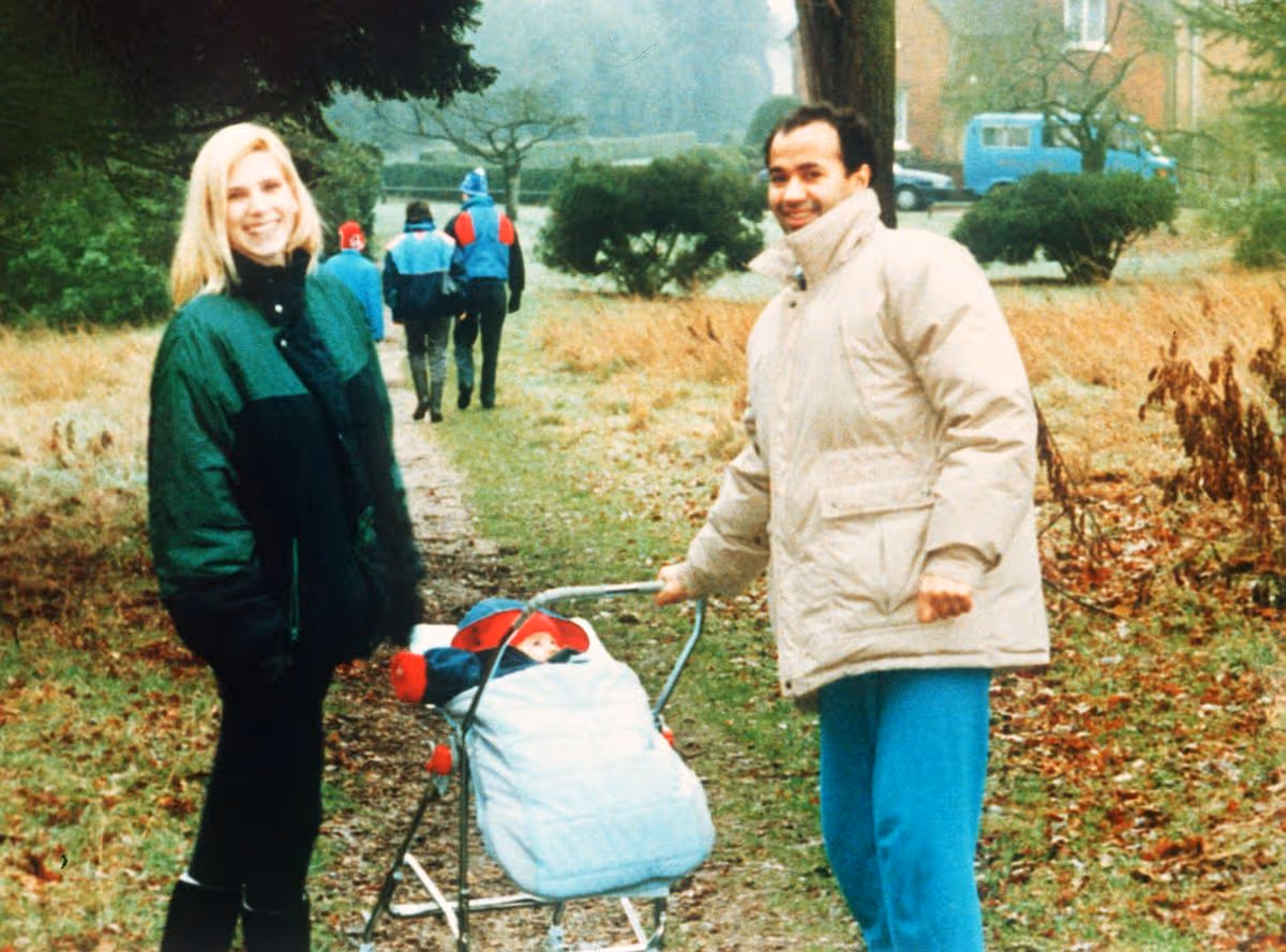
Rachel Nickell had her whole life ahead of her when it was cruelly stolen in a sickening attack – leaving her toddler son as the sole witness.
In July 1992, the 23-year-old mum was strolling through Wimbledon Common with her two-year-old son Alex Hanscombe, and their dog Molly. In a quiet, wooded area, she was ambushed, sexually assaulted and stabbed dozens of times.
Alex was later found by a passerby, desperately clinging to his mother’s body. In a heartbreaking attempt to help, the toddler had placed a piece of paper on her forehead as a makeshift bandage after pleading with her to wake up. Even at that tender age, Alex later revealed, he knew instantly that his mother was never coming back.
The brutal murder shattered the life of Alex and his father André Hanscombe. Yet, it would be 16 years for anyone to face justice. The haunting case is now the subject of a new three-part series for Netflix dramatisation, The Witness, alongside an accompanying documentary featuring never before seen archive footage, and deeply personal accounts from those who lived through the tragedy.
Among those interviewed is legendary forensic scientist Angela Gallop, whose work has helped solve many of the UK’s most high-profile murders, including the killings of Stephen Lawrence and Damilola Taylor.
Her team was handed the case in 2002, a decade after the murder, when the investigation had gone completely cold. They had agonisingly little to work with: a microscopic trace of male DNA recovered from the crime scene. To make matters even more difficult, forensic technology at the time was ill-equipped to handle such a minute sample. In order to find the killer, they had to pioneer an entirely new methodology to examine the sample.
Reinvestigating the decade-old DNA required immense precision. Describing the pressure and the patience required to manipulate the tiny shred of evidence, Angela said: “The technique that had been used at the time was a very new, sensitive method, but we had never particularly liked it in my laboratory.
“For Rachel’s case, we got hints of male DNA using our standard test, but we wanted to see if we could squeeze out some more information. By concentrating and purifying the DNA, we managed to achieve it, but it took two years to develop the technique properly.”
After a painstaking process, the team eventually got a strong enough DNA profile to add to their database – and it matched with a man named Robert Napper, a paranoid schizophrenic and serial rapist.
To ensure the case was ironclad, they raced back to the crime scene and analysed all the sample items that had been collected. Angela and her colleagues then went on to uncover footwear marks and forensic paint evidence linking Napper directly to Wimbledon Common.
His footwear was matched directly to the mud profiles taken from the area, and microscopic paint flakes matching Napper’s toolbox were discovered trapped in the hair of two-year-old Alex. The box, found in Napper’s flat, contained knives and other weapons.
The new DNA breakthrough was enough to convict Napper and exonerate Colin Stagg, the innocent man wrongfully targeted by a flawed police honey-trap operation. A new Netflix documentary will examine the botched investigation, which led to Stagg – a local resident who walked his dog on the common – spending 13 months behind bars in custody, and facing rampant speculation that he killed Rachel.
He was freed by an Old Bailey judge in 1994, who criticised officers for using a ‘honeytrap’ undercover policewoman to try to make him confess to the murder, branding the entrapment evidence as “reprehensible”
Mr Justice Ognall, who halted the trial, described officers actions as “deceptive conduct of the grossest kind” after undercover officer “Lizzie James” tried to seduce Stagg, promising a relationship in the hope of getting a confession. Stagg later received £700,000 compensation from the Home Office.
In 2008, Napper admitted manslaughter on the grounds of diminished responsibility and was detained indefinitely at Broadmoor. He was already incarcerated at the psychiatric unit, having been convicted in 1995 for the equally depraved double killing of single mother Samantha Bisset, 27, and her four-year-old daughter Jazmine.
Discovering the match provided a profound sense of justice for Angela’s team, particularly regarding the human toll of the investigation. “We had a DNA result that hit a match on the National DNA database, so the police have got something to investigate,” she said.
“There was an added level of satisfaction because Colin Stagg had been professing his innocence for all those years. We were able to show that he was telling the truth,” she said.
The new documentary about the 1992 murder features Alex describing the moment that he knew his mother had died after being stabbed 49 times.
A home video video captures him describing the moment his mother was killed on Wimbledon Common to his dad André, who gently discusses what his son saw on the day.
Now 36, Alex describes seeing Napper, telling his dad: “I saw him first,” he says, telling Andre that the man was carrying a bag which he opened. Asked what he took out, he replies simply: “A knife.”
He then tells his dad that the man “knocked me over” and that he witnessed his mum being stabbed. “There’s his knife,” the little boy tells his dad, indicating the picture he is drawing of his mother. “I saw the knife. I saw it, Yeah, I saw it all.”
Speaking in the trailer for the film, André explains: “My son saw his mother’s murder but nobody could have possibly known how long it was gonna take to find the person who did this.”
Ahead of the Netflix show, Angela is keen to emphasise that DNA evidence is rarely a simple “magic bullet.” Television would make people think that experts can simply swab a crime scene and receive a clear-cut result just 30 minutes later, Angela said, adding: “If it was going to be really straightforward, the original scientists would have discovered the truth a long time ago.
“You have to be much more clever. Sometimes you have to look for one type of evidence to find another. In the Stephen Lawrence and the Pembrokeshire Coastal Path murders, it was analysing textile fibres that led us to finding blood traces and therefore DNA.”
As well as the archive footage, the documentary will explore how Angela’s work led to justice for Stagg after her breakthrough solved the case.
The three part drama, The Witness, will follow Alex and André as they deal with the devastating impact of losing Rachel. Jordan Bolger plays André, while Max Fincham is the teenage Alex. Both men acted as consultants on the series.
The story aims to show how a father and son “moved through the aftermath of unimaginable tragedy, from darkness into light.”
The other cast include Kevin Eldon as DCI Mick Wickerson, Neil Maskell as DI Keith Pedder, Mark Stanley as DS Ivan Agnew, Jon Pointing as DC Nick Sparshatt, James Dryden as DC Paul Miller, Kerry Godliman as André’s mother June, James Bradshaw as DCI Tony Nash and Claire Rushbrook as Dr. Jean Harris-Hendriks.
In a joint statement released last month, André and Alex Hanscombe said: “Our life has been a battle. We can never express how indebted we are to everyone that’s been a part of this, for the kindness and generosity they’ve extended to us, for the chance they took with us in bringing our story to the screen, and for the care they have taken.
“Our journey has all been by the grace of God and a promise to go on together, and we feel incredibly blessed to be able to share our story in this way.
“We hope that audiences will be left with a testament to the tough battle of life we all face and to the power of faith, hope, love – and never giving up.”
- Documentary The Murder of Rachel Nickell has been made to accompany the new drama about what happened that day, called The Witness. Both will be released on Netflix on June 4.