‘Bless you, Alfred Wainwright … and you, Rishi Sunak’: England’s Coast to Coast walk gets an upgrade | Walking holidays
A soft breeze tickled the waters of Innominate Tarn, sending ripples dashing across the pool, bogbean and tussock grass dancing at its fringes. From my rocky perch atop Haystacks, I gazed down on Buttermere and Crummock Water glistening to the north, the round-shouldered hulks of Pillar and Great Gable looming to the south. A pair of ravens cronked indignantly, protesting against the intrusion on their eyrie; otherwise, stillness reigned.
Bless you, Alfred Wainwright, I murmured, picturing the hiking legend whose ashes are scattered around this lonely tarn. And then, surprising myself: you too, Rishi Sunak. In very different ways, both had brought me to this most spectacular of Lakeland crags.
It’s a little over half a century since Wainwright, patron saint of fell walkers, sketched a line on the map linking the Cumbria and Yorkshire shores. Not, of course, at random.
“The route follows an approximate beeline … from St Bees Head on the Irish Sea to Robin Hood’s Bay on the North Sea,” he wrote. “The grandest territory in the north of England is traversed by it; indeed, two-thirds of the route lies through the areas of three national parks.”
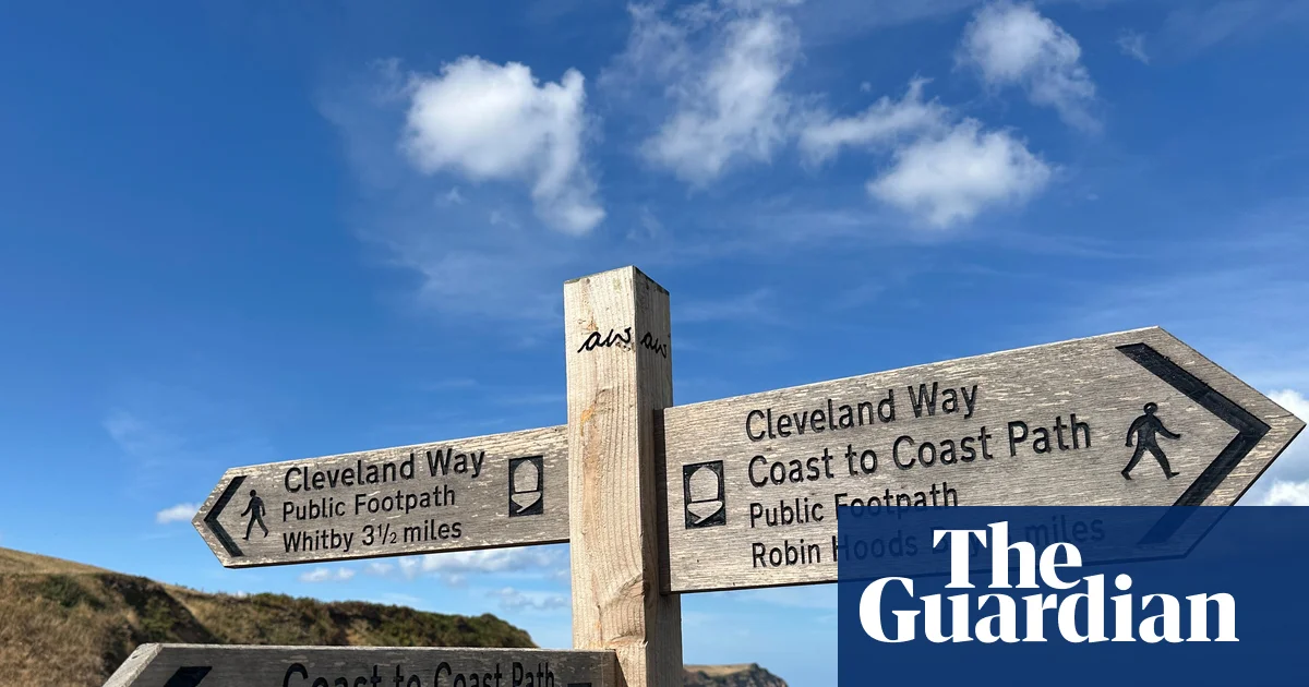
Today Wainwright’s Coast to Coast path is possibly Britain’s most popular multi-day trail, snaking more than 190 miles through the Lake District, Yorkshire Dales and North York Moors national parks. Curiously, though, it isn’t marked on OS Maps. Some stretches don’t even follow a public right of way. Yet.
“Rishi Sunak, whose constituency encompasses the central part of the route, campaigned for its designation as a national trail,” explains Angela Hobson, Yorkshire Dales Coast to Coast project manager. “Previously there were issues with signposting, trail maintenance, even sections that didn’t have access formally agreed.”
Natural England, which administers national trails, announced the project in 2022, backed by £5.6m funding, to be completed “early 2026”. It involved a host of work – resolving legal issues of land access; upgrading and repairing paths, bridges and other infrastructure; improving signposting and waymarking with the distinctive acorn symbol; appointment of dedicated trail officers, and other aspects. But what practical difference will this status make – to walkers, to the environment, to local communities and businesses?
To find out, I tackled the route – joined for some stretches by my partner Sarah – over 12 often exhilarating, sometimes exhausting days starting from St Bees, covering between 12 and 23 miles and bedding down in a different inn or B&B each night. The proof, after all, is in the plodding.
It soon became clear that upgrades will probably be least palpable in the Lake District. Although some 6,000 tramp the route annually, contributing perhaps £7m to local economies, that’s a drop in the ocean for one of Britain’s most visited national parks, which welcomes close to 18 million visitors a year. Signposts are conspicuously absent on fell tops here, preserving the sense of wildness – and that looks unlikely to change. So the addition of green diamonds to the OS Map, indicating a waymarked route, will be a boon to those, like me, who are navigationally challenged. And there are other tangible infrastructure improvements.
That became apparent on day one, as I descended the first real hill, Dent, down Raven Crag, where photogenically curly horned Herdwick sheep modelled obligingly. At the bottom I followed Nannycatch Beck, meandering through an elfin realm as magical as its name, beneath rowan and hawthorn, between sheer valley sides clad in bracken and coconut-scented gorse – and crossing pristine wooden footbridges to which subtle new Coast to Coast signs are affixed.
The following day, I was grateful for repairs to trails around limpid Ennerdale Water and Honister Pass. Likewise in Wainwright’s favourite vale: “The Lake District is the loveliest part of England,” he proclaimed, “and Borrowdale is the fairest of its valleys.” Along the Derwent, here a babbling baby stream shaded by venerable oaks, the splendidly christened Willygrass Bridge has been renewed.
Crossing into the Dales, I ambled through fractured limestone pavement erupting through the turf like so many broken molars. Once more, impacts of National Trail work were evident. “Many international guests have never experienced peat hag before,” notes Nick, who – with his partner Rachel – runs the fabulous Old Croft House B&B in Kirkby Stephen, where I stayed, dishing up local lore, advice and slabs of luscious chocolate cake. “Sections of the path were so muddy, and saw so many walkers each year, that it became a quagmire 30 or 40 metres wide. Now old flagstones reclaimed from the region’s mills have been laid up to and across White Mossy Hill, making it accessible in pretty much all weathers. Some say they spoil the sense of wilderness, but they protect that fragile environment as well as making navigation easier.”
Up towards the Brobdingnagian cairns on Nine Standards Rigg, I discovered a new long, snaking trail of heavy-duty stepping stones which protect precious peat and delicate moss ecosystems – and keep boots dry. Passing the route’s midway point, the postcard-pretty Swaledale village of Keld, and climbing on to the moor above Muker, past the ruins of gloriously named Crackpot Hall. Following the newly realigned path to the lead-mining relics around Swinner Gill and Gunnerside Gill, a concealed otherworld where the remains of pit buildings, channels and smelters only add to the enchantment.
Beyond Richmond’s bulky castle (built by Alan the Red, my new favourite Norman), and fuelled by tea loaf topped with a wedge of creamy local wensleydale, I left the Dales to cross the flat agricultural Vale of Mowbray. Past Ingleby Cross, at the gateway to the North York Moors national park, the ascent through the silver birches and ferns of Scarth Wood is a welcome return to hillwalking, tracing the northern scarp of the Cleveland Hills. Improvements, from new National Trail signs to replacing stiles with gates, will benefit local people, not just long-distance hikers, North York Moors Coast to Coast project officer Bernie McLinden told me.
Perhaps the loveliest example came in Little Beck Wood on my final day, following May Beck to the waterfall of Falling Foss. In this broadleaf Arcadia of mossy boulders and ferns, soaring shale cliffs, chiming birdsong and melodious brook, I joined laughing families on stone paths laboriously laid by Bernie and volunteers, replacing slippery boardwalks. A few miles out from Robin Hood’s Bay and journey’s end, I recalled Angela’s words.
“I took my daughter up to White Mossy Hill and said to her: ‘You’ll be able to walk over this with your children, and they’ll be able to walk over it with their grandchildren,’” she beamed. “‘And I helped build it.’” Wainwright’s legacy, refreshed.
The trip was provided by Macs Adventure, which offers various Coast to Coast holidays, including a 14-day itinerary (12 days’ walking) from £1,579 including B&B accommodation, luggage transfers and route info. More relaxed, slower options are also available.