rain

J.J. Spaun surges late to win U.S. Open for his first major title

J.J. Spaun turned a sloppy mess of a U.S. Open at wet and nasty Oakmont into a thing of beauty at the end Sunday with two stunning shots that carried him to his first major championship.

First came his driver on the 314-yard 17th hole onto the green for a birdie that gave him the lead. Needing two putts from 65 feet on the 18th to win, he finished this storybook week by holing the longest putt all week for birdie and a two-over 72.

That made him the only player to finish under par at one-under 279. It gave him a two-shot victory over Robert MacIntyre of Scotland.

And it made the 36-year-old L.A. native a major champion in only his second U.S. Open.

The rain that put Oakmont on the edge of being unplayable might have saved Spaun. One shot behind at the start of the day, he opened with five bogeys in six holes. And then came a rain delay of 1 hour, 37 minutes.

Spaun recovered as so many others fell apart.

J.J. Spaun, left, celebrates with his caddie, Mark Carens, after making a birdie putt on the 18th green.

J.J. Spaun, left, celebrates with his caddie, Mark Carens, after making a birdie putt on the 18th green to secure victory at the U.S. Open on Sunday.

(Seth Wenig / Associated Press)

Source link

Storms may rain on Army, Trump birthday parade in D.C.

June 14 (UPI) — Rain may dampen President Donald Trump‘s plans Saturday night to celebrate the U.S. Army’s 250th birthday with thousands of troops, 150 vehicles and 50 aircraft.

The event also coincides with Trump’s 79th birthday and Flag Day.

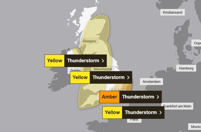
A flood watch was in effect for the entire region starting at 2 p.m. and is expected to last until 11 p.m. Highs will be well into the 80s and it will be humid during daytime festivities on the National Mall, WRC-TV reported, while forecasts show showers and thunderstorms starting around 3 to 4 p.m.

Guest entry for the military parade began at 2 p.m.

The one-hour parade, which is expected to draw several hundred thousand people, is scheduled to start moving down Constitution Avenue at 6:30 p.m. near the Lincoln Memorial and then proceed past the White House.

The parade, which saw people assemble along the mile-long route early Saturday morning, will end alongside the National Mall, near the National Museum of African American History and Culture and the Washington Monument.

The parade was originally planned to be smaller, but had been set to start outside the Pentagon and go 2.2 miles.

Trump posted Saturday morning on Truth Social: “OUR GREAT MILITARY PARADE IS ON, RAIN OR SHINE. REMEMBER, A RAINY DAY PARADE BRINGS GOOD LUCK. I’LL SEE YOU ALL IN D.C.”

Trump is scheduled to speak during the parade.

“For two and a half centuries, the men and women of America’s Army have dominated our enemies and protected our freedom at home,” Trump said in a video posted to Truth Social in early June. “This parade salutes our soldiers’ remarkable strength and unbeatable spirit. You won’t want to miss it. Just don’t miss this one. It’s going to be good.”

The parade will be followed by the Army Golden Knights’ parachute demonstration and a concert at the Ellipse. A fireworks show will occur at 9:45 p.m., the U.S. Army said.

Earlier in the day, a birthday wreath was laid at Arlington National Cemetery and there was a fitness event at the National Mall. The Birthday Festival there will include opportunities to meet with Medal of Honor recipients, astronauts and soldiers.

All of the activities are free and there is tight security.

Matt McCool, the U.S. Secret Service agent in charge of the Washington field office, said “thousands of agents, officers and specialists from across the country” are deployed. People attending the parade or a related festival will be required to go through checkpoints with magnetometers.

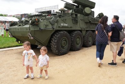
The big show will be the military equipment during the parade, officials have said, which includes 140,000-pound Abrams tanks, as well as 6,600 soldiers wearing uniforms representing every U.S. conflict dating back to the Revolutionary War and aircraft flying overhead

About 1,800 Soldiers from III Armored Corps in Fort Cavazos will participate.

“The Army’s 250th birthday is a once-in-a-lifetime event,” Col. Kamil Sztalkoper, a spokesperson for the III Armored Corps, said earlier this week as a train carrying tanks left Fort Cavazos, Texas.

“This is a chance to see our soldiers, our leaders and the world-class force on full display in our nation’s capital. We look forward to being a part of history,” he said.

On June 14, 1775, the Second Continental Congress voted to establish the Continental Army, more than a year before the Declaration of Independence.

D.C. officials have expressed concern about potential road damage from the vehicles, including 60-ton tanks. While the Army has installed thick steel plates at key turns, the straightaway on Constitution Avenue remains unprotected.

Road closures and security measures will make it difficult to drive around the area, and Mayor Muriel Bowser said potential damage could cost millions but the Army has pledged to cover the costs.

The Federal Aviation Administration is also clearing the airspace in the area, preventing all arrivals and departures at Reagan National Airport “during the peak of the celebration,” the agency said. The stoppage is expected affect about 116 flights, a senior government official told NBC News.

The last major military parade, the National Victory Celebration, was on June 8, 1991, to celebrate the end of the Gulf War, though Trump has noted that other countries regularly celebrate the end of World War II.

“We won the war, and we’re the only country that didn’t celebrate it, and we’re going to be celebrating big on Saturday,” he said.

Trump said he came up with the idea after watching the French Bastille Day military parade in France in 2017.

Pentagon personnel at the time convinced him not to move forward with the plan and, instead, in 2019, he celebrated Independence Day with a speech at the Lincoln Memorial with military aircraft flyovers and Bradley tanks stationed near the Lincoln Memorial.

“Humans are drawn to pageantry,” Barbara Perry, a presidential historian at the University of Virginia’s Miller Center, told NBC News.

“It’s usually about the personnel. Now we know that this president has political issues all around the world, and wanting to show off the might. And if he views it, as in his first term, ‘his generals,’ and, if he views it as ‘his military,’ then you tie it to your personal special day of your birthday- – that’s what’s different.”

On Friday night, U.S. Capitol Police arrested 60 people for unlawful demonstration, the agency said.

Military veterans and their families had gathered in front of the Supreme Court, demanding that taxpayer dollars for Saturday’s military parade and for troops in Los Angeles should be used for housing, healthcare and food.

“If there’s any protester that wants to come out, they will be met with very big force. I haven’t even heard about a protest, but you know, this is people that hate our country, but they will be met with very heavy force,” Trump told reporters earlier this week.

“It will be a parade like we haven’t had in many, many decades here,” he said. “And it’s a celebration of our country. It’s a celebration of the Army, actually.”

About 2,000 protests are planned nationwide against Trump spending millions on the parade, as well as his policies. No organized “No King” protests are planned in the nation’s capital.

But there was an event demonstrating against the military events by RefuseFascism on Saturday afternoon. They led a rally and marched outside the White House.

Trump “is forging and putting on display today a military loyal, not to the Constitution, not to the rule of law, but to Trump personally with all the White supremacy,” one of the chief organizers, Sunsara Taylor, told CNN.

A 20-year Navy veteran also told CNN: “The parade don’t belong here – you see that in dictatorships, okay? You see that in North Korea, you see that in China, you see that in Russia. This is we the people of the United States of America,”

Source link

Met Office issues fresh thunderstorms warning for this weekend with up to 50mm of rain to hit in hours

THE MET Office has issued a fresh warning for thunderstorms this weekend, with up to 50mm of rain expected to fall in just a few hours.

The alert signals the arrival of severe weather, bringing the risk of flooding, hail, and lightning strikes across the UK.

UK thunderstorm warning map.

4

There is also a follow-up amber warning that continues until 5am on MondayCredit: Met Office
Lightning striking over houses.

4

Lightning strikes in the sky along Church Street in Witham, Essex
Lightning strike over houses.

4

During the thunderstorms, some parts of the UK could receive up to 50mm of rain

Brits are urged to be prepared as intense storms are set to hit several regions, sparking concerns of widespread disruption.

The weather warnings will affect several areas, including London, the South East, and the East of England, until 5am Sunday morning.

There is also a follow-up amber warning that continues until 5am on Monday.

The Met Office has highlighted the risk of “fast flowing or deep floodwater” that could endanger lives, with some communities potentially becoming cut off due to flooding.

During the thunderstorms, some parts of the UK could receive up to 50mm of rain in just a few hours.

This will bring major disruption, including road closures, train cancellations, and power outages.

The Met Office also warned of the potential for strong winds, reaching up to 50mph, which could exacerbate the impact of the storms.

Met Office meteorologist Alex Deakin commented that the day would start off “hot and humid,” with some areas of the country potentially seeing temperatures climb as high as 30°C.

However, conditions will soon change, with thunderstorms beginning around 2pm in Wales and the South West, spreading to other areas later in the day.

Parts of southern England, including London, could see temperatures remain as high as 28°C on Friday evening, though the heat will quickly give way to more unsettled weather.

With 30–50mm of rain expected in some areas before the storms ease early on Saturday, residents across Greater London, Plymouth, Bath, Brighton, Norwich, and parts of the South East are advised to remain alert.

Cardiff and other southern regions could experience the heaviest downpours, with some areas possibly receiving up to 80mm of rain.

This level of rainfall is likely to cause significant surface water flooding, making driving conditions dangerous and leading to the risk of accidents.

The situation has already caused significant flooding in parts of the South West, particularly in Plymouth, where local residents battled knee-deep water.

The storms have already resulted in closures, with some roads, such as Gdynia Way and Kings Street, shut down due to flooding.

The Theatre Royal in Plymouth has also closed its doors as a result of flood damage.

James Mackenzie-Blackman, Chief Executive and Artistic Director of TRP, stated: “The torrential rain has required us to close the Theatre Royal today as we continue to deal with a significant flood into our basement.

Our priority is the safety of our staff, our artists, visitors and participants.”

In addition to the potential flooding, strong winds of up to 50mph are expected to cause problems along coasts and hills, further complicating the situation for drivers and emergency services.

Local authorities have advised caution when travelling, particularly in affected areas, as there may be delays and possible cancellations to train and bus services.

The disruption could continue into the weekend, particularly in areas where floodwater lingers.

The Met Office has issued a warning about the increased risk of power cuts, especially in areas where storms bring lightning strikes.

Residents are urged to be prepared for the possibility of service interruptions, with some homes and businesses potentially losing power due to the extreme weather.

This follows Friday’s amber weather warning for thunderstorms, hail, and lightning strikes.

The public is encouraged to monitor the weather closely and take precautions to protect themselves and their property.

Person walking in heavy rain with an umbrella and a balloon in a plastic bag.

4

Brits are urged to be prepared as intense storms are set to hit several regions, sparking concerns of widespread disruptionCredit: PA

Source link

Rain, lightning disrupt opening games of regional playoffs

There was rain, lightning and some comedic reactions for the strange June weather Tuesday that disrupted the opening day of the Southern California regional baseball and softball playoffs.

“Is it raining in June?” asked a stunned El Camino Real baseball player as a downpour fell in Woodland Hills before a Division 2 game against Point Loma. Two fans used artificial turf to shield their heads during a drizzle.

The Division 1 baseball game between Patrick Henry and host Santa Margarita was halted in the fourth inning with Patrick Henry leading 2-0 because of lightning. It will resume Wednesday. The Division 1 softball game between Poway and Ayala was postponed because of rain.

Most games eventually were played and finished.

Point Loma 6, El Camino Real 4: Trailing 6-1 going into the bottom of the seventh inning, the City Section Open Division champions gave Point Loma a scare, scoring three runs and having the bases loaded with two out until Hunter Weller ended the game with a strikeout in a Division 2 opener. Point Loma is the Division I champion from the San Diego Section.

Druw Frost had three hits. A three-run seventh aided by an El Camino Real error helped the Pointers. Phoenix Brant struck out five in 6 1/3 innings. RJ De La Rosa, JJ Saffie and Gavin Farley had RBI singles in the seventh for El Camino Real.

St. John Bosco 2, St. Augustine 1: Jack Champlin picked up the save after strong pitching from Griffin Tagliaferri and Brayden Krakowski. Moise Razo gave the Braves the lead in the third with an RBI double. St. John Bosco will host Villa Park on Thursday in the Division I semifinals.

Villa Park 5, Granite Hills 4: It took nine innings for Villa Park to prevail on the road. Nate Lewis had four hits and three RBIs, including the tiebreaker in the top of the ninth.

Crespi 4, Mater Dei 3: Mikey Martinez hit a three-run home run and Jackson Eisenhauer threw two hits of shutout relief with four strikeouts. Crespi will play the winner of Santa Margarita-Patrick Henry on Thursday.

University City 5, Birmingham 2: The Patriots gave up four runs in the seventh to fall in a Division III opener. University City will play Dos Pueblos, a 10-2 winner over St. Anthony.

Venice 5, Trinity Classical 2: Canon King had a double and triple and Daniel Quiroz added two hits and two RBIs for Venice, which will play at Mt. Carmel on Thursday.

Banning 3, Lemoore 2: The Pilots won their Division IV opener. Angelo Duarte had a walk-off single in the seventh. AJ Herrera had two hits and two RBIs.

Softball

Westlake 5, Rancho Bernardo 3: The Warriors won in Division II and will host Eastlake in the semifinals. Olivia White had a home run.

Legacy 5, Elsinore 4: Isabella Medina had two doubles in the Division III win. Breann Lipold hit two home runs for Elsinore. Legacy will play at St. Bonaventure, a 6-5 win over Southwest EC.

Source link

UK weather: Brits to soak in rain ‘EVERY DAY’ next week after Bank Holiday washout with heavy showers and 50mph winds

THE UK was battered by 50mph winds and heavy rain last night, as the country braces for wet weather.

Forecasters have warned that it will rain every day next week, in what will be a very wet start to June.

Couple eating ice cream on a seaside promenade.

4

Until now, Brits have been enjoying unseasonably warm weatherCredit: Alamy
Tourists sheltering under umbrellas in heavy rain.

4

However, heavy winds brought a downpour with them on Saturday eveningCredit: Alamy
Weather map of the UK showing wind gusts.

4

The weather won’t improve until the June half-term holidayCredit: X/@metoffice

The news comes after Britain experienced one of its driest Mays on record, with some parts of the country prepping for droughts. 

The North-West and North-East have also experienced their driest starts to the year since 1929, with Brits basking in sweltering 27C heats. 

According to Met Office meteorologist Becky Mitchell, though, that seasonal abnormality has come to an end.

She said: “Last night’s rain won’t have brought May much closer to average.

“That being said, we still have a week left of May and we expect to see rain every day, so by the end of the month we could be closer to the monthly average.”

Fellow meteorologist Zoe Hatton added that showers will sweep across the country from Sunday onwards.

She said: “Across the north of the countryside of Scotland is likely to be wet and quite miserable initially.

“A band of rain will be moving eastwards overnight lingering in the far north of Scotland. Elsewhere it’s not going to be widely wet.

“There’s going to be low cloud in places which could produce outbreaks of rain across the Pennines and across higher ground in the south of England, but the main focus will really be northern Scotland.

“As the day moves on that band of rain will move eastwards and we’re going to see showers arriving from the west.

“The most likely places affected will be Northern Ireland, Scotland and the north of England, and some quite frequent blustery showers across parts of the country, but drier further south.”

Heavy winds peaked at 50mph in the north of England on Saturday, while temperatures across the country will peak at a meager 15C on Sunday.

Some southern areas, including London, could experience highs of 21C, though, on Wednesday and Thursday.

However, Becky has warned that the warmer weather might not return until the school half-term.

Temperatures will begin to rise after June 2, bringing an end to what is believed will be a very wet week. 

Over the last few months, Britain has experienced a variety of rare weather conditions with meteorologists warning of a tornado on May 21.

One spokesperson said: “It’s not out of the question that we could see a funnel cloud, maybe even a brief tornado across parts of the South East.”

UK could be hit by tornado, Met Office warns as thunderstorms & heavy rain bring end to dry spell – check areas at risk

Tornadoes form when hot, humid air collides with cold, dry air.

The cold air heads downwards, while the hot air rises – creating a funnel, which eventually spirals into a tornado. 

Due to the UK’s landscape and normally temperate weather, tornadoes are a rarity in Britain

Weather map of the UK showing wind gusts.

4

Wind speeds will reach a staggering 50mph in the NorthCredit: X/@metoffice

Source link

Dodgers overcome bullpen woes and rain to beat Mets in 13 innings

The upcoming month was already going to be tough for the Dodgers.

A rainy Friday night in Queens made it that much tougher.

In the fourth game of a 29-game stretch against playoff-contending teams, the Dodgers beat the New York Mets in a marathon contest at Citi Field, overcoming a three-run ninth-inning blown save from closer Tanner Scott by prevailing 7-5 in the 13th inning.

But, their already shorthanded pitching staff endured more unexpected obstacles in the process. A one-hour, 38-minute rain delay in the top of the third limited starting pitcher Clayton Kershaw to just two innings. A seemingly never-ending game forced their overworked bullpen to combine for 11 more innings in which every reliever was used except one.

Navigating this difficult portion of the schedule — which began in earnest with a three-game series against the Arizona Diamondbacks this week — will be a test for a Dodgers pitching staff missing three of its five opening-day rotation members and many other important arms in the bullpen.

Because of that, manager Dave Roberts has emphasized in recent days the need to push his starters to take down as many innings as possible.

On Friday, Kershaw seemed to be on his way to a decent start, pitching two scoreless innings in which his only baserunner reached via a walk that was quickly erased by a double play.

Dodgers pitcher Clayton Kershaw delivers in the second inning Friday against the Mets.

Dodgers pitcher Clayton Kershaw delivers in the second inning Friday against the Mets.

(Pamela Smith / Associated Press)

But then, with the Dodgers mounting a rally in the top of the third, the New York skies opened up for a late May downpour. For the next 98 minutes, fans scattered for shelter and watched the Knicks’ playoff game on the stadium scoreboard. Back in the visiting clubhouse, Roberts watched the clock tick and tick and tick, eventually to the point where keeping Kershaw in was no longer a viable option.

By the end of the night, that was the least of the Dodgers’ problems.

Despite holding a 5-2 lead after getting three innings of two-run ball from Matt Sauer, and three scoreless innings from Ben Casparius, Scott couldn’t get the game across the finish line.

A chart examining the strikeout leaders in MLB history and where Clayton Kershaw stands.

Starling Marte led with a single. Pete Alonso drew a one-out walk. Jeff McNeil got them both home on a triple hit just high enough to evade a leaping Freddie Freeman at first base. Tyrone Taylor then completed Scott’s fourth blown save in 14 opportunities with an RBI single to left.

Somehow, the Dodgers (32-19) still managed to prevail.

Alex Vesia got the game to extras, stranding two runners aboard to end the ninth. Both teams then traded wasted opportunities from there, failing to score their automatic runners in the 10th (when the Dodgers had the bases loaded with no outs), the 11th (when Anthony Banda and Luis García combined to escape a bases-loaded threat) and the 12th (when the Dodgers turned an inning-ending double play while employing a five-man infield).

Finally, Teoscar Hernández put the Dodgers back in front in the 13th, hitting a leadoff RBI double before scoring on Andy Pages’ sacrifice fly.

García closed it out in the bottom half of the inning, completing a 2 ⅓ scoreless inning appearance just minutes shy of 1 a.m. local time.

It was a hard-fought win, but one that could come with future consequences for a pitching staff that was already running on fumes.

Grounds crew members cover the field during a rain delay at Citi Field on Friday night.

Grounds crew members cover the field during a rain delay at Citi Field on Friday night.

(Pamela Smith / Associated Press)

Source link

Remarkably dry start to spring set to end as rain forecast for parts of the UK in just hours & some could get thunder

RAIN is set to fall in just hours in parts of the UK, marking the end of the remarkably dry start to spring, the Met Office has forecast.

Some areas could even see thunder as the skies open up amid the driest start to the season in nearly six decades.

Pedestrians with umbrellas on Westminster Bridge in heavy rain.

2

Rain could be on the way today across major cities in the UKCredit: Alamy
Crowded beach with sunbathers and beach umbrellas.

2

It comes amid the driest start to spring in six decades, with Brits enjoying temps as high as 29C over the past few weeksCredit: Alamy

The Environment Agency has also warned there could be a risk of a drought this summer without sustained rainfall, with millions of households told they may face water restrictions in the coming months.

As of Friday, just 80.6mm of rain has been recorded for the UK this spring – that’s almost 20mm less than the record low of 100.7mm, set in 1852 for the full season.

However, this could change imminently, as the Met Office has warned of showers landing in the north of the UK throughout Monday.

Met Office meteorologist Kathryn Chalk explained showers hit across southern Scotland and northern England overnight on Sunday, with some reaching as far south as Wales.

Heading into Monday morning, there are expected to be “much-welcome” showers across the central belt of Scotland, northern England, and Northern Ireland.

Cities such as Edinburgh and Glasgow in Scotland could be washed out by the rainfall, as could Manchester in the north of England.

Met Office meteorologist Dan Stroud added that Monday would see sunny spells in the west develop widely with a “few scattered showers developing across the north during the course of Monday afternoon”.

He added: “One or two of those could be heavy, potentially thundery, but most places are going to be warm and dry.”

However, from Tuesday onwards there could be “an increasing chance of showers across southern areas of the country,” Dan said.

“Then beyond that, Thursday and Friday are likely to become dry, fine and sunny again, with good deals of sunshine for much of the country.”

Conditions in the UK this spring had been “remarkably dry up until now”, Dan explained.

However, as we approach the final week of May, which is also when schools break for half-term, the weather is “looking increasingly changeable, with areas of cloud and rain arriving from the west”.

The Met Office explained the prolonged warm and very dry spell, which has seen Brits enjoy temperatures as high as 29C, was primarily caused by high pressure.

However, by Tuesday, changing conditions could see “occasional heavy and potentially thundery showers developing across parts of Wales and the Midlands, with one or two of those breaching into London“.

Discussing Wednesday’s forecast, Dan said: “It will be a bit of a chilly start across England and Wales with plenty of sunshine to kick the day off.

“But showers will develop across England and Wales, with some of those showers potentially heavy and thundery and breaching into the London area.”

Met Office forecast

Today: Cloudy at first, but turning brighter with warm, sunny spells developing for most.

Mainly dry, though showers bubbling up in the west, perhaps turning heavy or thundery during the afternoon.

Tuesday to Thursday: Sunshine and showers for some on Tuesday and Wednesday, these perhaps heavy and thundery at times.

Drier on Thursday with bright or sunny spells. Locally chilly overnight.

Source link