South Sudan became the world’s newest country in July 2011 after nearly 99 percent of voters chose independence from Sudan.
Fifteen years later, most of the major promises that came with independence remain unfulfilled.
Recommended Stories
list of 4 itemsend of list
South Sudan remains one of the world’s most fragile states.
Oil finances nearly 90 percent of the government’s revenue, but the country remains wracked by deep inequality and violence: 82 percent of the population lives below the poverty line, and political jostling between rival groups has left the young nation in a perpetual state of conflict.
A woman poses with her three-year-old daughter in their house which is made out of straw, bamboo and plastic sheeting at the Protection of Civilian site (PoC) in Bentiu, South Sudan, on February 15, 2018 [File: Stefanie Glinski/AFP]
Elections have never been held since independence, millions remain displaced, and the country’s economy depends on pipelines running through Sudan, the very nation it fought to leave.
‘A failed promise’
Jok Madut Jok, 57, a professor and director of graduate studies at Syracuse University, is from Warrap, South Sudan, and still has family in both rural and urban parts of the country.
Jok says he recalls the joy of the time when South Sudan broke away to establish a new beginning. It was a moment of hope. Today, though, he feels as though he has been denied all that was promised at the time.
“South Sudan at the moment is a failed promise,” he says. “South Sudanese who had lived under brutal regimes in Sudan and had been excluded from money and development programmes, and were victims of security operations in the southern part, had hung their hopes on independence.”
Jok says people are now looking towards possibilities of political transitions to hold their government accountable.
Who controls what in South Sudan?
The country is technically governed by a transitional unity government created under the 2018 peace agreement.
But that peace remains fragile.
Violence continues across Jonglei, Upper Nile, Unity and Equatoria states with clashes involving government forces, opposition fighters and other armed groups.
Elections scheduled several times since independence have again been delayed, with the latest vote planned for late 2026.
Main political and armed groups:
Sudan People’s Liberation Movement (SPLM)
The ruling party which led the independence movement.
Led by Riek Machar, it is part of the unity government. It still maintains armed forces in parts of the country.
South Sudan People’s Defence Forces (SSPDF)
The national army, formerly known as the SPLA, it is loyal to President Salva Kiir.
White Army
A loose network of armed youth, mainly from the Nuer ethnic group.
National Salvation Front (NAS)
It remains active, mainly in Equatoria province. The NAS never fully joined the peace agreement.
A South Sudanese military police officer sits on a pickup truck while monitoring the area as troops belonging to the South Sudanese Unified Forces take part in a deployment ceremony at the Luri Military Training Centre in Juba on November 15, 2023 [File: Peter Louis Gume/AFP]
Who runs the government?
Salva Kiir – President since independence.
Leader of the governing SPLM.
Supported largely by influential sections of the Dinka, South Sudan’s largest ethnic community.
FILE – South Sudan’s President Salva Kiir attends the swearing-in ceremony for Kenya’s new president William Ruto, at Kasarani stadium in Nairobi, Kenya on September 13, 2022 [File: Brian Inganga/AP]
Riek Machar – Vice President.
Leader of SPLM-IO.
Historically backed by many Nuer supporters.
His rivalry with Kiir triggered the 2013 civil war after political tensions exploded inside the ruling party.
South Sudan’s rebel leader Riek Machar speaks to the media about the situation in South Sudan following a peace agreement with the government in Addis Ababa, Ethiopia, August 31, 2015 [File: Mulugeta Ayene/AP]
Independence delivered, violence continued
Between 2011 and 2026, according to data compiled by the United States-headquartered Armed Conflict Location and Event Data (ACLED), there were 13,256 attacks in South Sudan, which means 883 attacks per year on average – or more than two a day.
The majority of the attacks have been led by:
Various communal and clan-based armed groups. These constituted 6,168, or just over 46 percent, of all attacks.
The armed forces and police, who were responsible for 3,278 attacks.
Unidentified armed groups, behind 2,276 attacks.
Sudan’s People’s Liberation Movement-in-Opposition, responsible for 900 attacks.
National Salvation Front, behind 269 attacksForeign actors, behind 154 attacks.
Others, responsible for the remaining 184 attacks.
Jan Pospisil, 52, a researcher at the Austria-based Peace and Conflict Evidence Platform, recently conducted a survey of more than 22,000 respondents in South Sudan.
Of them, 98 percent said they were proud of being South Sudanese. At the same time, more than 52 percent of respondents said in 2023 that they didn’t feel safe speaking up politically, and in 2025, the results were approximately the same.
Hunger persists after 15 years of violence
Hunger is worsening across South Sudan, where an estimated 7.8 million people are facing crisis levels of food insecurity between April and July 2026, about 280,000 more than projected last year, according to the Integrated Food Security Phase Classification.
Of those, about 73,000 people are living in catastrophic conditions, facing starvation, extreme food shortages and a heightened risk of death.
Another 2.5 million are in emergency conditions, while 5.3 million more are struggling to meet daily food needs without exhausting what little they have left.
The nutrition crisis is worsening alongside this.
An estimated 2.2 million children under five now require treatment for acute malnutrition, an increase of about 90,000 cases since the previous assessment.
Another 1.2 million pregnant and breastfeeding women also need urgent nutritional support.
The crisis is being fuelled by conflict, displacement and repeated shocks that have destroyed livelihoods, disrupted markets and cut communities off from aid.
“My family is living in rural areas, some in the cities but have no access to quality healthcare, no clean drinking water, no road infrastructure,” Jok says. “Even if they were to farm and raise cattle, and create their own livelihoods, they usually are cut off from markets and from basic services that are the responsibility of the state, especially a state that extracts public resources from underneath the people.”
“It’s a feeling that people are totally excluded from the gains of independence,” he added. “It verges on criminal neglect.”
Villagers collect food aid dropped from a plane in gunny bags at a village in Ayod county, South Sudan, by the World Food Programme (WFP) on February 6, 2020 [File: Tony Karumba/AFP]
Economic inequality
Pospisil says despite the riches of the 150,000 barrels of oil that are extracted, sold and mainly exported every day, broader economic gains are not a reality for most of the public.
In most rankings, South Sudan languishes as the poorest nation in the world.
South Sudan mainly exports crude to China, but also has Chinese and Indian companies invested alongside state-held organisations that own blocks in the oil fields.
Paris and other European cities are experiencing temperatures above 40C (104F), reaching levels normally seen across the Middle East.
A blistering heatwave has gripped much of Europe, prompting the highest-level red alerts in parts of the United Kingdom, France, Spain and Italy.
Authorities have warned of health risks, wildfires and travel disruptions as extreme temperatures persist.
Recommended Stories
list of 3 itemsend of list
With temperatures approaching record highs, officials have taken emergency measures, including a localised alcohol ban in parts of France under red alert, nationwide heat warnings in Germany and the cancellation of a World Cup fan zone screening in Madrid, where temperatures hit 39C (102F).
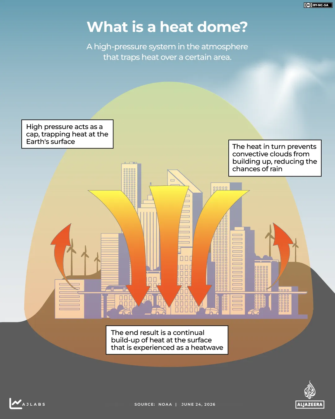
Why is it so hot in Europe?
A persistent area of high pressure, known as a heat dome, has trapped hot air over Western Europe, bringing clear skies, weak winds and prolonged sunshine. Hot air moving north from North Africa has added to the extreme temperatures.
(Al Jazeera)
Unusually warm seas around the UK, Ireland, France and the western Mediterranean have also helped keep coastal areas hot, especially at night. Coastal waters around Spain have reached record warm levels, according to Spain’s port authority.
In the worst-affected areas – western France, England and Wales – daily average temperatures have soared more than 12C above the 1991-2020 baseline, according to Copernicus data.
(Al Jazeera)
Scientists say the early-season heatwave is part of a broader warming trend. Europe is the world’s fastest-warming continent, with temperatures rising by approximately 0.56C per decade since the mid-1990s, more than double the global average.
Climate change is making heatwaves more frequent, more intense and likely to occur earlier and later in the year.
How hot are European cities today?
To contextualise the temperatures Europe is dealing with, Al Jazeera looked at the maximum temperatures in five European capitals on June 24 and compared them with cities across the Middle East, North Africa and Asia, where high temperatures are more typically experienced.
Europe is particularly vulnerable – much of its housing and infrastructure was not built for prolonged extreme heat, and only about 20 percent of European homes have air conditioning.
The graphic below shows how European cities’ maximum temperatures today compare with some other cities around the world:
(Al Jazeera)
How is temperature measured?
The temperature you see on the news or the weather app on your phone relies on a network of weather stations positioned around the globe.
To ensure accurate readings, weather stations typically use specialist platinum resistance thermometers placed inside shaded instruments known as a Stevenson screen.
Measurements are taken at a standard height of 1.25-2 metres (4-6.5 feet) above the ground. This provides a reading that reflects the air temperature that people actually feel.
(Al Jazeera)
There are two well-known scales used to measure temperature: Celsius and Fahrenheit.
Only a few countries, including the United States, use Fahrenheit as their official scale. Most of the world uses the Celsius scale, named after Swedish astronomer Anders Celsius, who invented the 0-100 degree freezing and boiling point scale, although originally inverted, in 1742.
Why does the temperature feel hotter than the forecast says?
Air temperature alone often doesn’t match how hot it feels to your body. That is why forecasts report a “feels like” temperature, which adjusts air temperature based on factors like humidity, wind speed and sun exposure.
(Al Jazeera)
Humidity
Humidity measures how much water vapour is in the air. This moisture slows the evaporation of sweat, so your body can’t cool itself as effectively.
Wind speed
In hot weather, a light breeze can help evaporate sweat, making it feel cooler.
Sun exposure
Even if the thermometer reads the same, direct sunlight adds extra warmth, which is why shaded areas feel cooler.
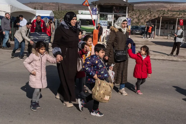
Approximately 1.3 million Syrians returned from abroad in 2025, nearly three times the figure recorded the previous year, while a further two million internally displaced Syrians went back home, cutting the global Syrian refugee population from 6 million to 4.9 million.
On December 8, 2024, the al-Assad dynasty, which lasted 54 years, was removed from power by a rebel offensive.
The 14-year-long war led to one of the world’s largest migration crises, with some 6.8 million Syrians, about a third of the population, fleeing the country at the war’s peak in 2021, seeking refuge wherever they could find it.
More than half of these refugees, about 3.74 million, settled in neighbouring Turkiye, while 840,000 found refuge in Lebanon and 672,000 in Jordan.
Hiam told Al Jazeera she returned to Syria with her family after more than a decade of living in a host country. “The reason that pushed us to return was the high cost of living we were facing in the host country. We stayed there for 12 years, and it was a great hardship for us as refugees.”
We returned to Syria, thank God, but in the beginning it was difficult because we didn’t find homes or anything. Syria now is completely different from when we left. The return was very difficult at first – the scene was very hard for me.
“But thank God, I became stronger. The first period was very difficult, and at the beginning, it was hard to cope,” Hiam explained.
Syrian families living in Turkiye walk towards the Cilvegozu border gate to cross into Syria, after Syrian rebels ousted President Bashar al-Assad on December 13, 2024, in Cilvegozu, Turkiye [Burak Kara/Getty Images]
According to UNHCR data, some 556,00 Syrians returned from neighbouring Turkiye, 465,000 from Lebanon and 256,000 from Jordan.
More than seven in 10 returnees have reported improvements in security and freedom of movement in Syria, according to the UNHCR. Almost three-quarters of Syrian refugees abroad have also said they would eventually like to return home.
Returns in 2026 reached 549,800 by mid-May, driven by deteriorating conditions in Lebanon.
June 17 (UPI) — Georgia Republicans on Wednesday rejected GOP efforts to redraw the state’s congressional and legislative maps amid a wider national push to redraw congressional maps.
Georgia Gov. Brian Kemp, a Republican, had last month scheduled the special session for Wednesday to consider redrawing the state’s maps in response to pressure to do so following the Supreme Court‘s April ruling that weakened Voting Rights Act protections for district lines drawn to preserve minority voting power.
The state’s House speaker, Jon Burns, said in a letter Wednesday to Kemp that Georgia’s House and Senate Republicans would not take up his redistricting call, citing more pressing cost-of-living issues and cases pending in court that could affect any alterations they adopt to their maps.
“Changes to Georgia’s maps should take place only when members of the General Assembly and citizens have been given ample opportunity to gather the facts, provide input and engage in meaningful discussion,” Burns said in the letter.
“For this reason, we will not be taking up congressional or legislative redistricting for the 2028 election cycle during this special session.”
Protesters swarmed the Georgia Capitol on Wednesday to demonstrate against redistricting. Videos posted online by the NAACP show supporters within the legislative building chanting “Black voters matter” at the Republican lawmakers who had congregated on the central sweeping staircase for a press conference.
When Senate Pro Tempore Larry Walker III remarked during the press conference that the Supreme Court ruling meant Georgia would need to redraw its maps, he was met with boos from the demonstrators.
“We believe it would be wise to allow the judicial process to develop in other states and see how the courts rule on redistricting maps elsewhere. With this guidance, we are confident that Georgia’s new districts will ultimately withstand legal scrutiny and that Georgia will prevail in defending these maps before the court,” he said.
“Because any changes to our current congressional or legislative districts would not go into effect until 2028, we believe it is prudent to take the appropriate and necessary time to do this important duty the right way and not to rush through it.”
Democrats celebrated the announcement, while arguing state Republicans had little choice but to shelve the effort in the face of opposition.
“State Republicans can see the backlash from voters coming this November, which is why they called off their plan to further rig maps,” Heather Williams, president of the Democratic Legislative Campaign Committee, said in a social media statement.
“But let’s be clear: The threat of future GOP gerrymandering looms, which is why building Democratic power in Georgia this year is crucial.”
Several, mostly Southern GOP-led or -aligned states have sought to redraw their maps following the Louisiana Vs. Callais decision, which threw out Louisiana’s 2023 congressional map with two majority-Black districts and cleared the way for the state to use a map with only one. The decision is widely seen as an opening to redraw maps that weaken minority voting power on partisan grounds.
Though any redrawn maps in Georgia wouldn’t take effect until 2028, Kemp called Wednesday’s special session amid a wider President Donald Trump-led effort to have GOP-led states shore up additional red seats ahead of November’s midterm elections.
Trump, who has voiced concern about impeachment proceedings and investigations if Republicans lose the House, has pushed GOP-led and -leaning states to redraw their maps to create new Republican-aligned districts and increase chances of holding onto the lower chamber.
GOP-led Texas became the first state to redraw its map last summer, setting off a gerrymandering arms race with the Democrats seeking to create new blue-leaning districts to neutralize Republican gains.
At least 10 states have completed redistricting efforts according to the National Conference of State Legislatures, which is tracking mid-decade redistricting. Eight of the 10 newly redrawn maps are expected to favor the Republican Party.
For many Iranians, the most immediate threat is no longer just war, but water.
Years of drought, falling rainfall and unsustainable water use have pushed the country into severe water stress, depleting reservoirs, rivers and groundwater reserves. The US-Israel war on Iran has added further strain after reports of damage to desalination plants, pipelines and other civilian water infrastructure in the early weeks of the conflict.
Iran is classified by the World Resources Institute as facing “extremely high” baseline water stress, using more than 80 percent of its renewable water supplies each year.
In this visual explainer, Al Jazeera breaks down Iran’s worsening water crisis and what is driving it.
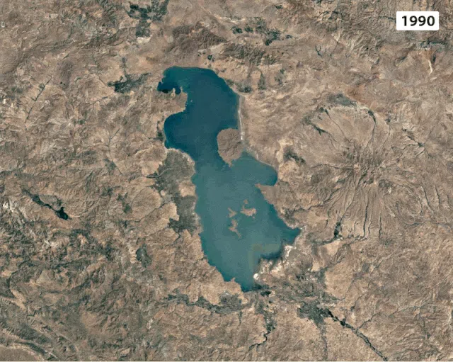
How Lake Urmia disappeared
One of the most striking examples of Iran’s water crisis can be seen from space.
A time-lapse display of Lake Urmia in northwestern Iran shows how the largest saltwater lake in the Middle East, which covered nearly 6,000sq km (2,300sq miles) in the 1990s, shrunk to just 581sq km (224sq miles), less than 10 percent of its former size.
A time-lapse view of Lake Urmia from 1990 to 2026 [Google Earth]
Consecutive droughts, agricultural water use, river diversion, and groundwater extraction have transformed vast stretches of Lake Urmia into exposed salt flats.
More than 60 dams built on its feeder rivers choked off inflows, while farmers diverted water into irrigation channels and decades of groundwater extraction drained the aquifers below. Rising temperatures accelerated evaporation as precipitation fell.
A view of Lake Urmia in 2014 [Kaveh Kazemi/Getty Images]
Iran’s growing water deficit
To sustain its freshwater resources, a country must replenish at least as much water as it withdraws for agriculture, industry, and household use.
Iran has long been on the wrong side of that equation. Decades of dam construction, intensive farming, and groundwater extraction have pushed consumption far beyond what rainfall can replenish.
In 2025, Iran’s 92 million people consumed around 100 billion cubic metres of water, nearly 13 billion more than its renewable resources could provide.
Agriculture is by far the largest consumer of water in Iran, accounting for about 91 percent of all withdrawals, compared with seven percent for households and two percent for industry. Yet much of that water is lost before it reaches crops, as ageing and inefficient irrigation systems waste a significant share of the country’s most precious resource.
Disappearing dams around Tehran
Iran is one of the world’s major dam-building countries, and has constructed hundreds of large and small dams to store water, generate electricity, and manage shortages.
In recent years, dozens of reservoirs have dropped to extremely low levels, leaving several to nearly run dry.
Before-and-after satellite imagery of Lar Dam, Latyan Dam and Mamloo Dam, all clustered around Tehran and the southern slopes of the Alborz mountains and forming part of the main water supply system for the capital region, reveals how water levels have declined over time as drought and rising demand strain Tehran’s water system.
Drought displacing thousands
Water scarcity is increasingly reshaping where Iranians can live.
As wells run dry and farming becomes harder to sustain, many families are leaving rural communities in search of more secure livelihoods. According to Abdolkarim Hosseinzadeh, Iran’s vice president for Rural Development and Disadvantaged Regions, only 38,000 of the country’s 69,000 villages remain inhabited, while 31,000 villages have been abandoned.
The pressure extends far beyond abandoned settlements. According to Iran’s state-owned Water and Wastewater Company, about 27,000 villages, home to more than 10 million people, are currently experiencing water shortages. In total, more than 70 percent of Iran’s villages are facing some form of water crisis.
Many migrants head towards major cities such as Tehran, Mashhad, Isfahan, and Shiraz. Yet these cities are facing water pressures of their own. Home to more than nine million people, Tehran has seen growing strain on its water system as drought and demand continue to rise.
The map below shows how Iran’s population is concentrated in the western half of the country. Today, roughly 75 percent of Iranians live on less than 40 percent of the country’s land area, concentrating both people and water demand in a relatively small region.
The effects of water scarcity can also be seen along the Zayandehrud River, once one of central Iran’s most important waterways.
Satellite imagery of Zayandehrud Dam reveals declining water levels upstream after years of drought and overuse.
Further downstream, the consequences become visible in the heart of Isfahan. The historic Allahverdi Khan Bridge (Si-o-Se Pol) was built over a river that sustained the city for centuries.
Today, residents increasingly encounter dry riverbeds beneath its arches as sections of the Zayandehrud repeatedly run dry.
The Si-o-se Pol (33-Bridge) historical bridge in 2017 [Thomas Schulze/Picture alliance via Getty Images]An Iranian man stands on the dried-up side of the Zayandehrud River as the Si-o-se Pol (33-Bridge) historical bridge is pictured in the historic city of Isfahan [Morteza Nikoubazl/NurPhoto via Getty Images]
Only a tiny fraction from desalination
Desalination accounts for only about three percent of Iran’s water needs, a stark contrast to Gulf neighbours, which depend on it for the majority of their drinking water.
Most of Iran’s desalination plants are located along its southern coast on the Gulf. As a result, desalination is largely concentrated in coastal cities, while inland areas such as Tehran, Isfahan and most agricultural regions rely on other water sources.
WASHINGTON — The Supreme Court ruled Tuesday night that Alabama Republican leaders may redraw their congressional voting districts to oust a Black Democrat and elect a white Republican.
The court’s conservatives, who ruled for Louisiana Republicans in a redistricting dispute, extended that decision to Alabama. The three liberals dissented.
The decision clears the way for the governor and state lawmakers to redraw their congressional voting map with six districts that favor Republicans and one that favors a Democrat.
“Weeks ago, I warned that vacating the District Court’s injunction in these cases would ‘unleash chaos and … confuse voters,’ ” Justice Sonia Sotomayor wrote in dissent. “Yet just as Alabama doubled down on racial discrimination, the Court today doubles down on chaos. Because I choose to defend the rule of law and the right of all Alabamians to participate equally in democracy, I respectfully dissent.”
The justices granted an emergency appeal that was backed by the Trump administration and set aside the decision of a three-judge panel in Alabama.
The court in a brief opinion said the three judges should not have blocked Alabama’s new map.
“While federal courts should not impose changes close to an election, states are free to decide for themselves whether last-minute changes to an election are in their best interests,” the court said.
Alabama’s emergency appeal went to Justice Clarence Thomas, who referred it to the full court.
Those three judges, two of them Trump appointees, ruled that Alabama’s state lawmakers discriminated against Black voters, who made up a near majority in the center of the state.
Three years ago, the Supreme Court agreed.
In a 5-4 decision written by Chief Justice John Roberts, the justices upheld the creation of a second district in the center of the state where Black voters had a near majority.
The result then was an Alabama state voting map that favored five Republicans and two Democrats for the House of Representatives.
But last month, in the wake of the Louisiana decision, Alabama’s lawmakers went back to court, arguing that the state may return to the voting map with only a single Black majority district.
In his appeal to the Supreme Court, Alabama’s Atty. Gen. Steven Marshall argued that the high court’s decision in favor of Louisiana “vindicates Alabama position on the lawfulness” of its earlier voting map. He said the state should not be penalized for “refusing to intentionally discriminate” to favor Black voters.
The court’s decision has cleared the way for Republican-led states in the South to flip congressional districts in Louisiana, Tennessee, Florida and now Alabama.
President Trump’s push to redraw the nation’s U.S. House districts received mixed results Tuesday as South Carolina senators defied his desires, but Missouri’s top court upheld a new map that could help Republicans win an additional seat in the November midterm elections.
Rather than waning, a national redistricting battle that began 10 months ago has intensified — inflamed by a recent U.S. Supreme Court ruling that weakened the federal Voting Rights Act and provided grounds for states to try to eliminate voting districts with large minority populations.
Republican lawmakers in Louisiana are wrestling with how politically aggressive to be when redrawing House districts after the U.S. Supreme Court invalidated a majority-Black district as an illegal racial gerrymander.
The ripples of the Louisiana ruling already have led to new U.S. House districts in Tennessee and have extended to Alabama, where Republican Gov. Kay Ivey announced an Aug. 11 special primary for four of the state’s seven congressional districts. That came after the U.S. Supreme Court on Monday overturned an order mandating use of a map with two largely Black districts. The state plans to switch to a map passed in 2023 that has only one majority-Black district.
Republicans think they could gain as many as 14 seats from new House maps enacted so far in Texas, Missouri, North Carolina, Ohio, Florida and Tennessee. Democrats, meanwhile, think they could gain six seats from new maps in California and Utah. The Virginia Supreme Court last week struck down a redistricting effort that could have yielded four more winnable seats for Democrats.
Missouri map splits Kansas City district
Missouri was the second Republican state, after Texas, to redraw its congressional districts at Trump’s urging last year. Since then, numerous other states have joined the redistricting battle.
During arguments earlier Tuesday, attorneys for voters challenging Missouri’s new map focused on changes to a Kansas City-based district long represented by Democratic U.S. Rep. Emanuel Cleaver, who previously was the city’s mayor, the first Black person to hold the post.
The new map takes a compact urban district that covered 20 miles and two counties and stretches it 200 miles over 15 counties, distorting it “into a sprawling behemoth that cuts clear across the state to unite territories that share nothing in common,” said Abha Khanna, an attorney who has represented Democrats in voting and redistricting cases across the country.
A lower court ruled in March that the map as a whole satisfied the compactness requirement, even though the Kansas City district is less compact. No Missouri court has ever struck down a congressional map for not being compact, said attorney John Gore, who defended the districts on behalf of the Republican Party.
A second case heard by the high court centered on whether the new map took effect in December, as asserted by Republican Atty. Gen. Catherine Hanaway and Republican Secretary of State Denny Hoskins, or whether it should have been suspended when referendum signatures were submitted.
To suspend the map before validating the signatures would let activists temporarily undercut laws by submitting boxes of fraudulent signatures, Missouri Solicitor Gen. Lou Capozzi argued.
But to not immediately suspend the map “would dilute the referendum right, if not destroy it altogether,” said attorney Jonathan Hawley, arguing for voters who sued.
Republican officials contend the new districts can be suspended only after Hoskins determines the petition meets constitutional requirements and has enough valid signatures. Hoskins has until Aug. 4, the day of Missouri’s primary elections, to make that determination. The Supreme Court upheld the decision of a state judge in March who agreed with Republicans’ position.
Louisiana hearing leads to death threats
Louisiana state Sen. Jay Morris, a Republican who drafted redistricting bills that would eliminate one or both of the state’s majority-Black districts, told lawmakers Monday that he received death threats after Friday’s contentious hearing in which he told members of the public to “shut up.”
Morris acknowledged the outburst but denied the Louisiana Democratic Party’s assertion — blasted across social media and in a news release — that he also used the derogatory term “boy” toward its executive director, Dadrius Lanus, who is Black.
State Sen. Gary Carter, one of three Black Democrats serving alongside six white Republicans on the Senate committee overseeing redistricting, told the Associated Press on Tuesday that he had withdrawn from the committee “to help restore the decorum and focus that this moment demands” after shouting at Republicans during Friday’s hearing. Carter publicly apologized Monday to Morris and his Senate colleagues for having “lost my temper” and for any remarks that were taken as “personal attacks.”
Carter is the nephew of U.S. Rep. Troy Carter, a Democrat who represents New Orleans and is at risk of losing his seat in the redistricting process. Gary Carter is being replaced on the committee with state Sen. Royce Duplessis, a Democrat representing New Orleans.
South Carolina weighs political risks of redistricting
The Republican push for South Carolina to join the national redistricting battle by redrawing its U.S. House map fizzled Tuesday as an initial vote in the state Senate fell short.
Trump had urged South Carolina to redraw its congressional districts ahead of the November elections in an attempt to help Republicans win another seat in the closely divided chamber. The state House had voted in favor of letting lawmakers return after the regular session ends this week to consider redistricting, and had proposed a new map that could eliminate the state’s only Democratic-held seat.
But the Senate had to give permission to take up redistricting, too.
The 29-17 vote failed, with just two votes short of the two-thirds needed. Five Republicans joined all the Democrats in the chamber to reject the proposal.
Trump said Monday on social media that he was closely watching the redistricting vote, urging South Carolina senators to “be bold and courageous” and to delay the House primaries so new districts can be drawn.
Although Republicans have a supermajority in the chamber, some GOP senators weren’t sure the proposed map would guarantee the party could unseat longtime Democratic U.S. Rep. James E. Clyburn. They also said it could push enough Democrats into other districts to backfire, resulting in a 5-2 or even a 4-3 Republican split.
Republican Senate Majority Leader Shane Massey acknowledged the pressure from Trump, but said he doesn’t like being asked to bend to someone’s will instead of doing what’s best for his state.
“I got too much Southern in my blood,” Massey said. “I’ve got too much resistance in my heritage.”
Lieb, Collins, Brook and Chandler write for the Associated Press. Brook reported from Baton Rouge, La.; Chandler from Montgomery, Ala.; Collins from Columbia; and Lieb from Jefferson City, Mo.
The Strait of Hormuz, a narrow waterway once carrying roughly a fifth of the world’s oil and gas, remains effectively closed after the United States and Iran imposed competing blockades.
Naval blockades are one of the oldest weapons in warfare, requiring no ground troops or invasion, just the ability to cut off what an enemy needs to survive. These blockades have reshaped economies, societies and alliances across generations, sometimes with instant shockwaves, sometimes with effects only seen later.
Recommended Stories
list of 4 itemsend of list
From Israel’s ongoing siege of the Gaza Strip to blockades during World War I, here are some notable naval blockades in modern history:
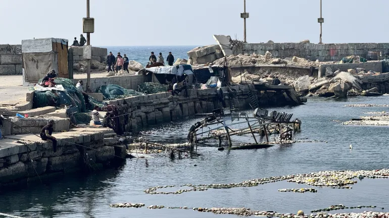
Israel’s siege of Gaza (2007-present)
A view of the severely damaged Gaza City port as fishermen work under difficult conditions due to Israeli attacks, March 8, 2025 [Hamza ZH Qraiqea/Anadolu]
Israel’s complete land, sea and air blockade of the Gaza Strip is one of the longest sieges in modern history.
Launched in 2007, Israel has limited the entry of goods and essential supplies, causing a prolonged humanitarian and economic crisis for the Strip’s 2.3 million people, who cannot travel freely.
Before Israel’s genocidal war on Gaza began in October 2023, fishermen were restricted to 6-15 nautical miles (11-28km) from shore, well below the 20-nautical-mile (37km) zone guaranteed by the Oslo Accords.
After 2023, with Israel’s policy of starving the population, fishermen have taken extreme measures to feed their families, leading to many being killed by Israeli fire.
Since 2008, several Freedom Flotilla vessels have attempted to break the Israeli blockade. Since 2010, all flotillas attempting to break the Gaza blockade have been intercepted or attacked by Israel in international waters.
On April 30, Israel raided 22 out of the 58 vessels in the most recent Global Sumud Flotilla campaign in international waters more than 1,000km (620 miles) from Gaza.
Blockade of Biafra (1967-70)
Nigerian troops entering Port Harcourt, after routing Biafran troops during the Nigerian Civil War [File: Evening Standard/Getty Images]
During the Nigerian Civil War, which began in July 1967, the Nigerian federal government imposed a land, sea and air blockade on the secessionist Republic of Biafra shortly after it declared independence.
The blockade led to widespread starvation, widely seen as a deliberate wartime strategy, transforming a territorial conflict into a global humanitarian crisis. Death tolls vary, but it is estimated that one to two million people died, the vast majority from hunger and disease rather than direct conflict.
The nearly three-year-long blockade ended with the Biafran surrender in January 1970.
Beira Patrol blockade (1966-75):
HMS Cleopatra’s Wasp helicopter encounters an engine failure at high altitude during the blockade on the Port du Beira in 1971; the aircraft was recovered after it crash-landed [File: 50tony Wikimedia Commons]
The Beira Patrol was a nine-year-long blockade by the British navy to prevent oil from reaching Rhodesia, present-day Zimbabwe, through the Mozambican port of Beira, enforced under United Nations sanctions following Rhodesia’s unilateral declaration of independence.
The blockade largely failed its strategic goal. Rhodesia continued receiving oil via South Africa and other Mozambican ports, which the UN resolution did not authorise the British navy to intercept.
Additionally, the cost to the United Kingdom was substantial. The operation tied up 76 naval ships over nine years, with two frigates required on station at all times.
The blockade ended in July 1975, when Mozambique’s newly gained independence from Portugal allowed it to credibly commit to blocking oil transit to Rhodesia, rendering the naval patrol redundant.
Cuban Missile Crisis ‘quarantine’ (1962)
A US official shows aerial views of one of the Cuban medium-range missile bases, taken in October 1962, to the members of the UN Security Council [File: AFP]
In October 1962, the US ordered a naval “quarantine” of Cuba after US U-2 spy planes discovered Soviet nuclear missile sites under construction on the island.
The US deliberately called it a “quarantine” rather than a blockade, which would have been legally an act of war, aiming to prevent the Soviets from bringing in more military supplies and to pressure them to remove the missiles already there.
The quarantine drew a line 500 nautical miles (920km) from Cuba’s coast, with US warships authorised to stop, search, and turn back any vessel carrying offensive weapons if necessary.
The crisis brought the world to the brink of nuclear war. The then-Soviet First Secretary Nikita Khrushchev called the blockade “outright piracy” and an act of aggression, and initially ordered ships to proceed. For several days, Soviet vessels steamed towards the quarantine line as the world watched.
The most dangerous phase of the standoff lasted 13 days. An agreement was reached in which the Soviets would dismantle their offensive weapons in Cuba in exchange for a US public declaration not to invade Cuba, and a secret agreement to remove US Jupiter missiles from Turkiye.
The naval quarantine was formally ended on November 20, 1962, after all offensive missiles and bombers had been withdrawn.
Blockade of Wonsan (1951-53)
US B-26 Invaders dropped para-demolition bombs at supply warehouses and dock facilities at the Wonsan port in North Korea in 1951 [File: Wikimedia Commons]
During the Korean War, UN naval forces led by the US imposed a blockade of the North Korean port of Wonsan in February 1951, lasting nearly two and a half years.
It aimed to deny the North Korean navy access to the city, which was strategically significant for its large harbour, airfield and petroleum refinery.
The blockade was preceded by a dangerous mine-clearance operation in October 1950. North Korean forces had been well supplied by the Soviet Union and China with sea mines, and during the clearance, the sweepers USS Pledge and USS Pirate were sunk, killing 12 men and wounding dozens.
The operation successfully constrained North Korean and Chinese forces on the east coast, forcing them to divert thousands of troops and artillery pieces away from the front line. UN forces also captured several harbour islands, which strengthened the blockade’s grip on the port.
The blockade ended after 861 days with the signing of the Korean Armistice Agreement in July 1953. By that point, allied naval fire had almost levelled Wonsan.
US submarine blockade of Japan (1942-45)
The US sinking of the Japanese destroyer Yamakaze on June 25, 1942 [File: US Navy via Wikimedia Commons]
The US imposed a submarine blockade against Japan during the Pacific War.
The blockade began taking shape in 1942, combining US naval submarine attacks on merchant shipping with minelaying operations to cripple Japan’s war capabilities, disrupt shipping and cut off vital supplies such as food and fuel.
As an island nation, Japan was especially vulnerable, almost entirely dependent on imports of oil, rubber and raw materials. Its economy and military could not function without open sea lanes.
Over the course of the war, US submarines sank some 1,300 Japanese merchant ships and roughly 200 warships. By 1945, oil imports had effectively ceased.
Food imports collapsed, causing significant shortages and malnutrition across Japan by 1945, though the extent of civilian starvation is disputed.
After the US dropped atomic bombs on Hiroshima on August 6 and Nagasaki on August 9, 1945, Japan announced its surrender on August 15, bringing the blockade and the Pacific War to an end.
Blockade of eastern Mediterranean (1915-18)
World War I map shows modern Palestine and Syria, published in 1918 [File: Wikimedia Commons]
In August 1915, during World War I, the Allied forces imposed a blockade of the eastern coast of the Mediterranean to cut off military supplies and weaken the Ottoman Empire’s war effort.
The declared area ran from the intersection of the Aegean Sea and the Mediterranean Sea in the north to the Egyptian frontier in the south. The blockade was initiated by Britain and France, later assisted by Italy and other Allied powers.
The consequences were devastating. Military supplies, munitions, oil, food and medicine were all targeted. The food crisis was compounded by a locust plague in 1915 and a severe drought, contributing to severe famine across Lebanon and Greater Syria.
Reports suggest the famine led to 500,000 deaths by 1918, mostly civilians, with Mount Lebanon losing an estimated one-third of its population. Mass migration followed.
The blockade remained in place throughout the war and lifted only when Allied forces occupied Beirut and Mount Lebanon in October 1918.
Allied blockade of Germany (1914-19)
German U-35 submarine sinking the French steamer, Herault, in the Mediterranean, off Cabo San Antonio, Spain, June 23, 1916 [Courtesy of the Library of Congress]
The British navy began blockading Germany almost immediately after the outbreak of the war in August 1914.
The naval blockade extended from the English Channel to Norway, cutting off Germany from the oceans.
Britain mined international waters to prevent ships from entering the ocean, creating danger even for neutral vessels.
Germany responded by declaring the seas around the British Isles a “military area”, prompting Britain and France to ban all goods to and from Germany.
The blockade’s most devastating consequence was famine. The winter of 1916-17, known as the Turnip Winter, marked one of the harshest years in wartime Germany.
The blockade had cut off food and fertiliser imports, a failed potato harvest left little to fall back on, and a breakdown in food distribution compounded the crisis. It is estimated that between 424,000 and 763,000 civilians died from diseases related to hunger and malnutrition.
The blockade was not yet fully lifted until July 1919, after the Treaty of Versailles had been signed.
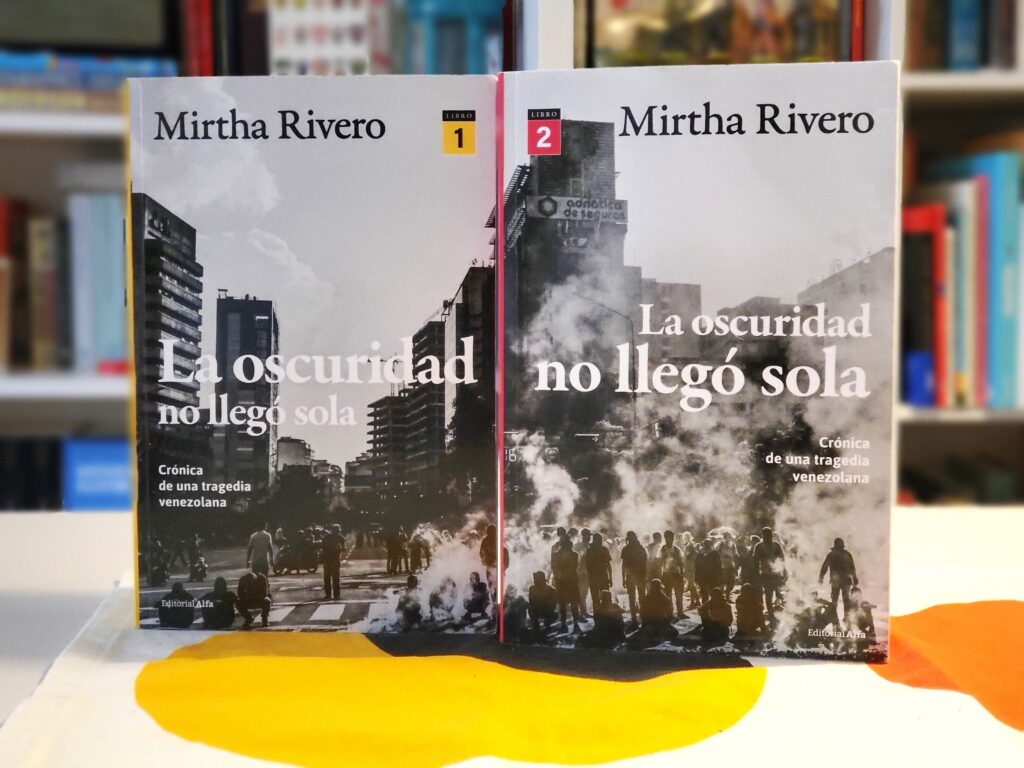
In an era of 150-page novels in 14-point font, and books on Venezuela’s recent history that feel like overly long opinion pieces, Ulises Milla’s Editorial Alfa opted for something entirely different: a chronicle of how chavismo took over the Venezuelan State between 1999 and 2004, the product of ten years of research, divided into two volumes totaling more than 1,400 pages.
It is titled La oscuridad no llegó sola (no English translation yet), taken from a line by a Colombian poet, and has a subtitle that speaks volumes: “chronicle of a Venezuelan tragedy.” Yes, it is a chronicle in the broadest sense of the term, a systematic and multifaceted account that protects a series of events from oblivion in a specific era. It is also a Venezuelan tragedy, one among many, in which everything leads to an unhappy ending that seems inevitable, as in those of Aeschylus or Sophocles.
There is a classical feel to Mirtha Rivero’s new work, not only because she has drawn on literary genres that are over two millennia old, but also because it is a book that took a long time to write, one made to transcend time. For this reader, it is another essential text about our past, like José Domingo Díaz’s chronicles of the First and Second Republics or Lisandro Alvarado’s Historia de la Revolución Federal, and certainly like Rivero’s previous work: the bestseller La rebelión de los náufragos, published in 2010. It does not attempt to impose a personal thesis, defend one side or one figure, or propose a solution to the nation’s ills. It is an effort to understand how things happened, on a scale vast enough to allow the patterns of behavior developed by political actors over those years to emerge.
For those of us who experienced these events firsthand, through the media, La oscuridad no llegó sola still reveals aspects of the story we didn’t know, thanks to the quantity and quality of its sources. For those who were too young, it is an unparalleled document on how the traditional political class underestimated chavismo, how chavismo took advantage of the negligence and frivolity of its adversaries to seize control of institutions, and how the anti-politics we saw explode in La rebelión de los náufragos helped demolish what little remained of that democracy, which committed suicide, or allowed itself to die. A tragedy that, with its variations, has happened before. And that will very likely happen again. La oscuridad no llegó sola by Mirtha Rivero is available on Amazon and in bookstores in Spain. From Monterrey, Mexico, where she has lived for several years, the economics journalist who is showing how Venezuela’s contemporary history must be written spoke with Caracas Chronicles.
I want to start with the moment when La rebelión de los náufragos was published, had the impact it did, and you began the journey that led to these two volumes. You addressed this in the preface to La oscuridad no llegó sola, but what was the process like for defining not only the 1999-2004 timeframe, but also the questions you wanted to answer?
After La rebelión de los náufragos was published, I didn’t immediately consider any other topics. It was the third book I had written, but it was the first one that was published, and its reception changed my way of working. It was like a shock. For a year and a half, I couldn’t think about another “topic” because I was adapting to that new reality. It was in mid-June 2011 that another topic emerged. I wanted to answer a question: What happened in the 2004 recall referendum? For me, it was personally very important because, as a result, my husband and I began looking for a new place to live. Did voting fraud occur or not? What was it like? How did we get to that point? So I marked the period: from Chávez’s inauguration on February 2, 1999, until the day of the referendum, August 15, 2004.
It wasn’t so much that chavismo was pressuring the Supreme Court, but rather that a large part of society favored a Constituent Assembly.
I had to go back quite far because Chávez didn’t appear out of nowhere. Nor did other figures: the architects who helped him set up his political machine, those who accompanied him from that day forward, and those who had been with him even before the 1992 uprisings didn’t appear out of nowhere. They all have a past and a reason for being there, just like the people who kept appearing in my research. I confirmed along the way that during those years, the foundations were laid and the entire structure that allows chavismo to endure was built. As I guide my narrative, I realize that I not only have to look back, but that I often force myself to project into the future. For example, I look back when I discuss the oil industry, which is an important topic in my chronicle, but I also look forward when someone talks about the changes in the judicial sphere that the 1999 Constitution imposed, and I’m going to the trial against Judge Afiuni in 2009.
I see. For me, La oscuridad no llegó sola is a twin of La rebelión de los náufragos, in its structure, its tone, and its intention: first, you show how the political class sacrificed democracy with Carlos Andrés Pérez and paved the way for chavismo, and now we see how it overestimated its own strength and underestimated Chávez. Was describing this hall of mirrors the plan, or did it emerge during the research?
It wasn’t the plan. I didn’t see it as a continuation, nor as a hall of mirrors: it turned out that way, the story led me there. Exploring the recall referendum was actually a pretext for me to delve into that era, which I was afraid of. What was important was what happened before the referendum. How the referendum was repeatedly postponed until Chavismo had all institutions and powers under its control, which culminated in the expansion of the Supreme Court, and how it was able to regain popular support through direct subsidies via the social missions. How the opposition promoted the recall referendum without having a candidate to challenge Chavismo if Chávez lost and elections were held.
What did you learn, while writing this book, about the ability of the various opposition leaders to interpret reality? Do you share the common opinion that popular support for Chávez was underestimated in 1998 and 1999?
I was very surprised by their inability to see what was right in front of them. We had already seen how short-sighted the political parties were, their reluctance to form and renew themselves, since the 1980s. This is evident in the conspiracy against Carlos Andrés Pérez in 1993, based on a check from the secret fund that had been annulled in 1989 and was used against him in 1992; in the corruption accusations made by (future chavista minister) José Vicente Rangel; in the resistance to the reforms of the Presidential Commission for State Reform; and in the insistence of the old leaders on remaining political bosses.
There were people who knew who this Hugo Chávez they were opposing really was, but even so, there were those clumsy last-minute maneuvers in the 1998 campaign, and they weren’t prepared for the scenario in which Congress would be eliminated, as Chávez himself had said would happen. They acted with great carelessness in the face of Chávez’s rise: society, the political parties, and even a political animal like Teodoro Petkoff underestimated him. I was very surprised that they didn’t know how to confront the lieutenant colonel, the authoritarian tendencies that came with him, the power-hungry Left that accompanied him, the people who applauded the military coup attempts of 1992. They offered no resistance when Chavismo abolished Congress, taking advantage of the anti-political sentiment that had also been brewing since the 1980s. The lack of vision, and even of any statesman-like discourse, on the part of the politicians, did surprise me greatly.
One of the book’s many achievements was to unearth and trace a somewhat forgotten but key episode: how the Supreme Court accepted the Constituent Assembly’s suspension of the Legislative Branch. Did that also surprise you, how they paved the way for the dissolution of the separation of powers? How much pressure was chavismo exerting on the Supreme Court?
It didn’t surprise me that much, because we experienced it firsthand. The chavistas had just come to power and were barely learning how to use it, and they couldn’t exert pressure before Chávez took office on February 2, 1999. It wasn’t so much that chavismo was pressuring the Supreme Court, but rather that a large part of society favored a Constituent Assembly, even though a constitutional reform would have sufficed. Many people believed that this Constituent Assembly would save the country, to create a new, bright, efficient nation. Everyone was riding that wave. As Simón Alberto Consalvi said, we cannot absolve the people of their decisions.
Some of your interviewees, as expected, fall into hindsight bias: assigning to certain moments a meaning that we see today but that wasn’t easy to discern then. For example, everyone in your book says they knew the 2002-2003 strike was a bad idea, but that “the majority decided”: Didn’t you yourself fall into hindsight bias? Because when I write about those years, I have to tell myself, “Remember what you thought then about the 2002 general strike, not what you think today.”
One can always fall into that bias because one isn’t objective, pristine, but I was very careful about that and made an effort to compare the accounts. Because many interviewees told me things that didn’t happen as they said; they were mixing what others had told them with what they would have liked to have happened. My own interpretations of a particular moment fell apart as I investigated. Sometimes the same scene had six different testimonies, and I had to cross-reference them, sometimes going back to the witnesses to confirm or discuss parts of their story. The good thing is that I encountered very little reluctance from the interviewees, although of course there were people who didn’t want to talk, who stood me up, and I even made trips for nothing.
Both the oil workers and the dissident military officers were convinced they were right and that they could convince some people, while these people already had a plan in place.
With those I did talk to, I sometimes confronted them, because now it turns out, for example, that nobody agreed with the national civic strike, or as we called it then, the “oil strike.” But the investigation was able to determine who truly resisted, and how society pressured for a repeat of what happened on April 11, even though it was so unlikely to have any effect.
April 11, 2002, is like the novel Rashomon; the same event is seen differently depending on many perspectives. But it’s quite well documented; much less known is what happened within PDVSA, and you contributed a lot to those of us who aren’t familiar with the oil world. How do you see today the role played by the oil executives when they decided to step outside their bubble?
Within that bubble were people like Edgar Paredes and Juan Santana who, having been involved in university politics, were politically savvy. They knew their place and what might happen, but also what they needed to do. They created that protest movement to rescue PDVSA. Society joined them because, in reality, it used the PDVSA conflict as an excuse to protest many other things, but the oil workers were trying to defend their company because, ever since Chávez was elected in ’98, they saw him as a threat. Naively, they believed they could change the policies because they came from a school of thought where debate and consensus were reached. But even during the 2002 strike, they continued fighting to rescue PDVSA. They were fighting for the country too, but to rescue the country, they believed, PDVSA had to be rescued. The same was true for the soldiers in Plaza Altamira. Right or wrong, they wanted to rescue the FAN (National Armed Forces) where they had made their careers, without understanding that they couldn’t, because the first political prisoners of chavismo were military personnel.
The idea that Chávez also provoked the April 11th march, or the movement to crush it, is a narrative he fabricated after those events.
Both the oil workers and the dissident military officers were convinced they were right and that they could convince some people, while these people already had a plan in place. They thought that the truth would prevail and that the people would act for the good of the country. But that wasn’t meant to happen. They suffered a lack of understanding of the country’s political history, of what the 1992 coups meant. Because they were caught up in their own business, in what they knew. In fact, not all the oil workers or the military saw Chávez as a threat and voted for him in 1998, like a large part of the country.
Reading the book, I came to feel more empathy for what the oil workers and even certain military personnel, did than for what the politicians did.
Because they actually did more than the politicians in terms of trying to rescue their respective organizations. With all their naiveté, the oil workers and the military did force others to act. They gave their all to try to save not only their professional world, but democracy itself.
The book makes it clear that Chávez sought out conflicts, he provoked them. Even the massacres, not to mention the strikes: he sought out battles because he saw them (and he was right) as opportunities to wipe out pockets of resistance. Right? Do you see this as a pattern that connects everything from the 2001 enabling legislation to the recall referendum?
Chávez sought out battles because it was his way of life. He always said, like Pinochet, that he was a soldier. I believe he launched the enabling legislation package in 2001 to impose his agenda, not to provoke, because I don’t think he knew it would generate such strong resistance, even though there had already been protests since 2000. He introduced those laws at the last minute and without consulting anyone because he was an authoritarian who believed he was the center of the world. The idea that he also provoked the April 11th march, or the movement to crush it, is a narrative he fabricated after those events. He knew there were disaffected military officers and expected a classic coup, which he planned to counter with civilians, but he didn’t provoke it, because in fact, his intelligence services ultimately failed him. Just as there are people who, after the strike failed, said they never agreed with it, he rewrote history to impose the narrative that everything was his agenda. But many things surprised him, even though he eventually managed to navigate each situation. However, after April 11th, he did dedicate himself to provoking conflicts, now with the advice of Fidel Castro, and surrounded by radicals like Alí Rodríguez Araque.
Another pattern I noticed is the persistence of anti-politics, how distrust of political parties shaped different situations. And you get the feeling that this still resonates with people, that three decades after the 1990s, anti-politics continues to define us, right?
The parties were already badly weakened, following a decline that began in the mid-1980s, and even more so after what happened with Pérez II. Their crisis became impossible to hide by the second year of Chávez’s presidency, but anti-politics was very much present during Chávez’s election itself, before that night of April 11, 2002, when decisions were made driven by the desire to remove politicians from important matters. Although politicians met, participated in discussion groups, and sought solutions on their own, such as promoting Adán Celis as transitional president, anti-politics was pervasive across all sectors and prevailed among the main actors who attempted to remove Chávez from power in 2002. The book includes testimonies from politicians who recount how the media favored the opinions of emerging civil society actors who viewed politicians as corrupt and stuck in the past. And yes, as you say, this continues today. Those in power still promote this idea of politicians as a corrupt caste that led the country to ruin. Because it’s very easy to blame politicians for something in which the citizenry also played a part.


![HMS Cleopatra's Wasp helicopter, No.463, encountered an engine failure at high altitude during the blockade on the Port du Beira in 1971. A crash landing occurred at sea and the aircraft was recovered. [File image.]](https://i0.wp.com/www.aljazeera.com/wp-content/uploads/2026/05/Wasp_463_a-1777774554.jpg?w=640&ssl=1)