You can’t own the beach in California. Our shoreline is public — thanks to the Coastal Act and the Coastal Commission — even when everything around it gets expensive and complicated. You can live next to it, monetize it and build a personality around proximity to it, but the wet sand itself belongs to everyone.
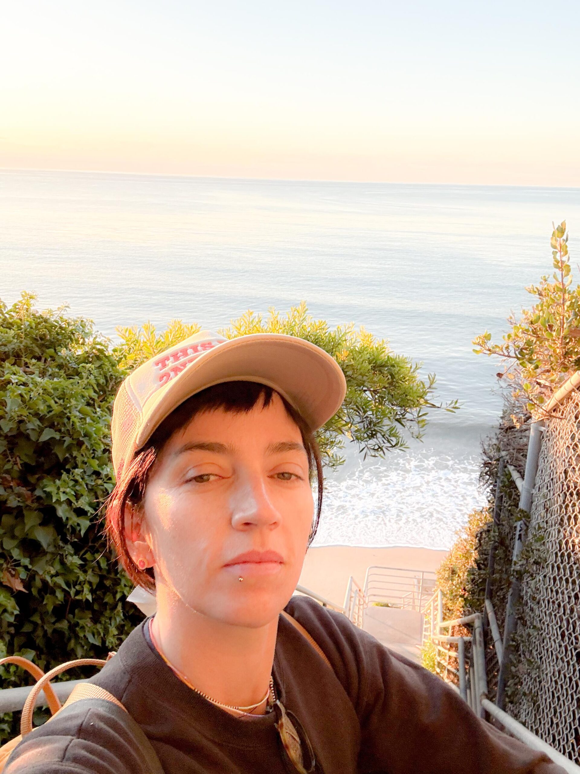
Jackie Snow takes a selfie by the new public stairs at Escondido Beach, also known as Hidden Beach.
(Jackie Snow)
In 2024, my colleague Jaclyn Cosgrove walked 27.4 miles of Washington Boulevard in a single day, from Whittier to the ocean. I read it in awe of the shape of it. One street. One day. A city revealed in a straight line.
And then a thought occurred to me, I could do something like that. What if I walked the entire L.A. shoreline? What would happen if I went to the beach and just kept walking along the crest of its waves? Except the shore does not reward this approach. It closes. It opens. Erosion pushes you onto the road and lets you back when it feels like it.
I set out to walk the 75 miles along the Los Angeles coastline anyway. I started at the mouth of the San Gabriel River and worked north toward the Ventura County line, taking 10 trips from the end of November to the second week of January, mostly waiting on tides and weather to cooperate.
Being a surfer helped. I already knew that wet sand means public access in California, that satellite view tells you things the default map doesn’t, and that tides can make or break an outing. For someone wanting to do a similar journey, the California Coastal Trail website is a valuable resource. You can walk long stretches and return back, but I went point to point, which means figuring out how to get back to your car. I usually Ubered, although public transit exists on some stretches. The slickest option is going with a friend who has a car: leave their car at the end, drive yours to the start, and walk. Their car is waiting at the finish to bring you both back to yours. Beyond that, bring more water than you think you need to especially as most stretches have no fountains, no services and no shade. Pack snacks that will sustain you throughout the journey, wear a hat and put on sunscreen, then reapply it. Even on gray, marine-layer days, you’re exposed for hours with nothing overhead.
If you’re inspired by this mega-trek but want to instead do a micro version, I suggest the 5.7 miles from Malibu Pier to Escondido Beach. You can park at one end and take a picturesque bus back where a tasty lunch at the pier’s Malibu Farm awaits at the finish. One last tip I picked up: be nice. People sometimes will give you water, or offer help, wanting to see you get to your destination too.
1
2
3
1.A red-tailed hawk perched on a coastal access sign along the boardwalk in Long Beach.2.A bench off the Long Beach boardwalk, near the start of the 75-mile walk.3.Birdhouses located near the Long Beach boardwalk.(Jackie Snow)
Alamitos Beach to Port of Long Beach: 4.9 miles
I start at the mouth of the San Gabriel River at Alamitos Park at about 10 a.m. on a busy Sunday at the end of November, walking with a friend. The first stretch is a flat, easy boardwalk. We stop at the Long Beach Museum of Art, which sits on the bluffs overlooking the water, and grab lunch at Claire’s, the museum’s outdoor cafe. From there, we walk toward the mouth of the Los Angeles River, passing through the marina, where boats sit quietly and a pirate ship is inexplicably for sale. We don’t make it up the man-made pier to the Queen Mary. Instead, we turn around just short of it, one river book-ending the other.
Looking back toward the marina near the mouth of the Los Angeles River, one river bookending the other.
(Jackie Snow)
Cabrillo Beach to Portuguese Bend Beach Club: 8.7 miles
I park at Cabrillo Beach, along the Port of Los Angeles, around 6:30 a.m. People are already playing ping-pong. Someone is dancing alone on the sand.
I start along the Cabrillo Beach Walking Path, which you enter at the south end of the beach where the sand ends and the bluffs start. In what feels like two seconds, I’m up on the cliffs, which quits partway and dumps me onto the residential streets of Coastal San Pedro, a neighborhood that looks quintessentially California. The houses are probably a few million dollars each, but they’re tidy bungalows, not the kind of aggressive beachfront wealth that makes you feel like you’ve wandered somewhere you’re not supposed to be.
I pass through Point Fermin Park, home to a lighthouse perched above the water. Down below, the beaches are rocky and loud. The waves are being sucked forcefully back out between the rocks, a sound that feels more industrial than oceanic. There’s more neighborhood walking on West Paseo Del Mar, interrupted by a Little Free Library stop where I add a few books to my bag. I hit the San Pedro hike trails, and the coastline turns dramatic, and suddenly I can’t step two feet off the path without risking a fall, but it’s breathtaking in its beauty.
Cabrillo Beach at the Port of Los Angeles, where the second walk began.
(Jackie Snow)
I hit another closed section, this one bordering Trump National Golf Club in Rancho Palos Verdes. Not wanting to end up on a Secret Service list that bars me from flying, I find another way around, on a surprising trail that curves between holes that’s part of the Ocean Trails Reserve. I climb down to the beach and start picking my way along the rocks toward the Portuguese Bend Beach Club, moving slowly and trying not to break my neck. You can definitely skip this part.
A security guard named Gilbert Blair waves me over and explains to me what I already know: I’m allowed to walk on the wet sand, but everything else is private. When I tell him what I’m doing, he starts offering advice, pointing out places on my Google map he thinks are closed because of last year’s heavy rains. This area is some of the shiftiest parts of all of California, with landslides going back all through the geographical record. In 2024, areas were moving 9 to 12 inches a week, although it has slowed down to 1 to 2 inches a week. He tells me the unstable land actually created a new beach, which the coast almost never does. People came from all over to see it, he says, gesturing toward a new form of sand that locals have called “unreal.”
Blair is nice, but not nice enough to wave me off the wet sand and through Portuguese Bend’s private roads so I can call an Uber. I have to backtrack, spending more time than I’d like carefully navigating the rocks. I briefly consider stopping at the nearby Trump National Golf Club to eat and use the bathroom, but I’m hot, sweaty and not in the mood to test my welcome.
The trail descending toward the rocky beaches below Point Fermin, where waves get sucked back out between the rocks with a sound more industrial than oceanic.
(Jackie Snow)
Terranea Beach to Palos Verdes Estates Shoreline Preserve: 5.4 miles
Based on Blair’s advice, I skip a section that isn’t open to the public and probably not safe. I drive Palos Verdes Drive South, a rutted, uneven road that skirts the area and feels vaguely off-roading. I park at Terranea Resort, which charges a fee, but there is also nearby free public parking. I pick the walk back up at the charming tucked-away Terranea Beach. As I head north, the trail climbs. I can see stretches of shoreline closed off, tantalizingly visible with no way to reach them.
I stop at the Point Vicente Interpretive Center, a modest but free museum perched above the water. Several people are gathered outside with binoculars, scanning the horizon. They tell me humpbacks were spotted farther out earlier, feeding. It’s easier to see them on the far side of Catalina, they explain, but they still watch from here, every day, sunrise to sunset, December through May. This is the Gray Whale Census and Behavior Project, run by the American Cetacean Society. Volunteers have been coming here for 43 years, counting whales as they migrate past the point.
The Point Vicente lighthouse, perched above the water where Gray Whale Census volunteers keep watch.
(Jackie Snow)
Volunteers with the Gray Whale Census and Behavior Project scanning the horizon. They’ve been counting whales here for 43 years.
(Jackie Snow)
After I peel myself away from looking for whales, the tides won’t allow me to climb down to Honeymoon Cove. I stay on the cliffs and admire the impressive houses around me. I continue until I round the Palos Verdes Estates cliffs, on Paseo del Mar, and see the long, flat stretch of built-up beaches unfurling ahead, South Bay-style, Malibu faint in the distance.
I’ve only done about 15 miles of my walk and suddenly I see how much more there is to go. I’m hot. I’m tired. I packed bad snacks. The sheer expanse of it, frankly, stresses me out. I had planned to make it to Rat Beach in Palos Verdes Estates, but I call it early.
The small coves that punctuate the Palos Verdes coastline, visible from the cliffs above.
(Jackie Snow)
Palos Verdes Estates Shoreline Preserve to El Porto Beach: 7.9 miles
I start back at Palos Verdes Estates cliffs. A couple of turns in, I come across my first real surf spot of the walk. I don’t think I’ve ever seen a surf break from this high up. The waves look less like waves and more like pulses of energy moving under the skin of the ocean.
When I finally hit Rat Beach and see how flat the coastline stretches ahead, I feel like dropping to my knees and kissing the ground. After days of cliffs and detours, the openness feels generous.
Hermosa Beach is busy with volleyball nets in use at a level that suggests Olympic aspirations. Forty minutes later, I stop atErcole’s in Manhattan Beach two blocks off the boardwalk and demolish one of its famed burgers. Instead of stopping where I planned, I keep going and end at my familiar surf spot El Porto.
Surfers walking out to the break at El Porto.
(Jackie Snow)
El Porto Beach to Ballona Creek Jetty: 4.8 miles
I’m back at El Porto Beach, this time walking a paved boardwalk through a thick, foggy marine layer with my husband and a friend who’s in town visiting.
Suddenly, my friend realizes he’s dropped his wallet somewhere north of El Segundo. Cue a round of retraced steps and mild panic. An angel named Dr. Gaz finds it, looks up my friend, and bikes it over so we don’t have to retrace any further. The wallet is returned. Our trio survives. We keep walking, stopping at Ballona Creek Jetty.
A dog and his man relaxing on the beach in Marina Del Rey.
(Jackie Snow)
Marina Del Rey to Will Rogers Beach: 7.4 miles
In this classic boardwalk stretch, we eye the muscle men of Muscle Beach, pause for a quiet break atSmall World Books in Venice and walk next to skateboarders (including one dressed as a Santa) in Santa Monica, before ending at Will Rogers State Beach.
The rocks and tide pools just past Malibu Lagoon, where the king tide pulled the water back farther than usual.
(Jackie Snow)
Will Rogers Beach to Malibu Pier: 7.7 miles
I do this stretch with my husband on New Year’s Day, parking at Will Rogers Beach Lot Three and timing it to a king tide. The highs are higher, but the lows are lower too, which is the part we’re interested in.
Even with the king tide low, the beach opens up and pinches closed without warning, and we move between wet sand, rocks we feel like traversing, and the shoulder of the Pacific Coast Highway when we don’t.
Soon enough, we hit the section of burned-out houses that still haunt the beach nearly a year later. I think I can still smell the smoke. It’s the quietest stretch of the whole walk, and the only place the emptiness feels like loss instead of calm.
The Malibu coastline near Escondido Beach.
(Jackie Snow)
When we finally reach the Malibu Pier, it feels like stepping back into civilization. People are on the beach. Nobu is packed. We eat at Malibu Farm and sit indoors, grateful for chairs, shade and food that isn’t trail mix.
Afterward, we take the bus back to the car from a stop near the Pier on the PCH, which turns out to be one of the most beautiful bus rides in existence, with the coastline framed perfectly by wide windows.
Malibu Pier to Escondido Beach: 5.7 miles
We come back the next day for another king tide, despite rain in the forecast. I start on the other side of Malibu Lagoon State Beach, which looks like nothing else on this walk. It’s swampy and green and quietly buzzing, reminding me of Florida, my home turf. Birders are out, rain jackets zipped, binoculars already up.
There are still rocks and little rivers to navigate, but the tide is so low it’s exposing tide pools I didn’t know existed up here. The sand is packed and forgiving, and we cover distance quickly until the rain really starts coming down.
We exit using the new stairs at Escondido Beach, also known as Hidden Beach, which were installed in 2023 after a multidecade battle over access. I take them slowly as I celebrate a mostly triumphant walk.
The Malibu coastline just south of Point Dume.
(Jackie Snow)
Escondido Beach to Zuma Beach: 6.7 miles
I head back to Escondido Beach, a few days later at low tide, though the tide is already coming in. That turns out to be a mistake. My second mistake is coming alone. As I scramble over rocks helpfully labeled with a sign warning not to climb on them, it’s dangerous, I notice my phone has no service. I decide the safest option is to soak my hiking boots instead along the incoming tide.
With my shoes sloshing and Google Maps satellite view looking deeply uncommitted to the stretch just south of Point Dume, I try to exit. Nope. Gated community. Not ready to give up, I keep going.
The surfer south of Point Dume whose companions offered to unlock the gate.
(Jackie Snow)
I spot a woman surfing and stop to take a photo. Her non-surfing companions start chatting with me. When they hear what I’m doing and where I’m trying to go, they offer to unlock the gate. It’s a genuinely kind gesture. But since I’m doing this for you, reader, I ask if there’s an exit farther along. They say there are stairs up ahead, probably reachable. I tell them, in the nicest way possible, that I hope I don’t see them again, and keep going.
My shoes are now collecting water on every step, the bottoms of my pants are wet, and everything underfoot is baseball-sized rocks, which I think is the worst possible rock size for walking. I round the curve. I spot the stairs.
If I had turned off satellite view, the stairs would have been obvious. So much for trying to read the coastline.
I climb out and walk to the tip of Point Dume and look south. I can see the South Bay, where I called it early weeks ago, hot and tired and hating my snacks. I’m still hot. I’m still tired. My snacks are still crummy. But standing here, salty and damp, I realize I don’t want this to walk to end.
The view from the cliffs near Point Dume.
(Jackie Snow)
Zuma Beach to county line: 5.3 miles
Today I timed the hike with a tide going out and my husband joins me so I don’t have a repeat from last time. We park along the PCH at Zuma. The first stretch we go by “Hannah Montana’s View,” a very persistent Google map label. It’s calm until a curve, where a gaggle of adolescent boys, shirtless and shoeless, are trying but failing to climb over the mussel-covered rocks ahead of us. For the second time on this walk, I have to turn around and back-track to the last exit, maybe a quarter mile back.
Luckily, the sighting of a Little Free Library makes the detour feel less like a failure and more like a reward. We cut through a small gated community that turns out to have a door for exactly this purpose, a quiet acknowledgment that people do, in fact, want to walk through here. There is so much rock walking. So much. Eventually we reach Leo Carrillo State Beach, where Los Angeles actually ends and Ventura County begins. Despite the name, County Line Beach is another mile or so away.
Gated Lechuza Point neighborhood has a beach access road that lets walkers get to the shore.
(Jackie Snow)
I watch people walk across the county border without noticing it at all, no fanfare, no announcement, no sense that anything has changed. They keep going. I stop. They are not done walking, but I am.
I haven’t seen every inch of the Los Angeles County coastline. I double-checked my walking distance and I’m still not at 75 miles, more like 65. The number I found online is probably not entirely accurate (the coastline is constantly changing). Maybe it’s closer to 70. But I have seen whale-watch perches, burned-out Malibu lots, crowded boardwalks and magnificent waves. The coastline is both fragile and welcoming — and walkable — if you’re willing to chase the tides.
People don’t come to White Point/Royal Palms Beach for a lazy day of sunbathing, they come here to explore. At low tide, the rocky shoreline is a maze of crater-like formations and tide pools where visitors crouch over searching for life. During my visit, two men poking around with fishing rods excitedly showed me a small octopus they had spotted in one of the crevices. It’s no wonder: White Point offers some of the most diverse tide pools in Southern California.
If you park in the upper parking and playground area, the experience starts to feel special before even reaching the water. Brass plaques placed throughout the bluff describe the area’s rich history, while dramatic, panoramic views of the rugged cliffs and stony coastline unfold below. From there, it’s about a 10-minute walk downhill to the beach itself. The rocky shore is not ideal for swimming, but scuba divers come to experience the underwater hot springs.
During a recent visit, construction equipment occupied one end of the beach due to work on a sewage line, though the lifeguard on duty assured me that treated wastewater is released about three miles offshore, where deep ocean currents disperse it before it can affect water quality at the coast.
Best for: dramatic views, tide-pooling, scuba diving, fishing
Bathrooms: Yes (additional portable toilets also available at bottom of hill)
Parking: Lot immediately after entrance (10 minutes downhill walk to beach) is free weekdays, $8 on weekends; there’s another lot right by the beach, which is $6 after 9 a.m. on weekdays, $8 on weekends
Dog-friendly: Leashed dogs are permitted on the paved trails beyond the rocks
ADA-accessible: ADA parking, but no wheelchair available due to the rocks
What’s nearby: The nearby White Point Nature Preserve offers 102 acres of coastal habitat and hiking trails. There isn’t much in terms of food or drink in this area, so bring sustenance and make use of the picnic tables on the beach’s upper bluff portion.
The Canary Islands are experiencing a tourism crisis, with activists warning the coastline is unsustainable as locals say the ‘land is being destroyed and speculated on’
Loopholes in planning regulations have enabled the destruction of miles of coastline(Image: Getty)
The Canary Islands have witnessed mounting demonstrations in recent years. Frustration has been building amongst residents, who argue the surge in tourism to the sun-soaked Spanish archipelago is unmanageable. They point to outdated regulations that allow property speculators to purchase land for hotels and holiday flats, while paying only minimal tax.
Consequently, Canarians claim they receive the lowest average salaries in Spain and face difficulties securing affordable accommodation. Yet now they have a further complaint against holidaymakers. The islands are suffering coastal erosion at an alarming pace. Campaigners say the Canary Islands’ coastline is on the brink of disaster.
Each year, based on a report from SOS Costas Canarias, approximately 21⁄2 miles of coastline disappears. Anne Striewe, the foundation’s director, states that hotels, apartment blocks, housing estates and marinas, amongst other structures, are being constructed on this “lost” territory.
The organisation cautions that throughout the eight islands, roughly 18% of the territory within the first 500 metres from the sea has already been developed. Beyond protected natural areas (PNAs), this figure skyrockets: it surpasses 40% on multiple islands and coastal sections, reaching 43% in Lanzarote and Gran Canaria.
Nearly 20% of the living space on the Canary Islands is dedicated to tourism – in comparison to around 4% on the Spanish mainland. Five municipalities on the Canaries possess more tourist beds than permanent inhabitants: Yaiza (Lanzarote), Pájara (Fuerteventura), Mogán (Gran Canaria), San Bartolomé de Tirajana (Gran Canaria) and Adeje (Tenerife).
Ms Striewe highlights that, beyond holiday accommodation, there is a vast array of tourist-related infrastructure including access roads, golf courses and desalination plants, which fail to show up in hotel occupancy figures yet remain part of the same problem.
Sharon Backhouse, director of GeoTenerife, told Sky News that the Canary Islands are a “biodiversity jewel in the Atlantic,” yet local authorities provide minimal protection for the islands’ natural habitats.
She warned that each year more “beautiful landscapes are cemented over” to make way for new tourist resorts.
She added: “The problem with these resorts is that we just don’t have enough resources in terms of water, what happens to all the rubbish, how is it all recycled.”
Carmelo Javier León, director of the UNESCO Chair in Tourism and Sustainable Economic Development at the University of Las Palmas de Gran Canaria (ULPCG), describes a conflict between those who wish to protect the islands’ natural beauty and “the development of ever more accommodation options.”
The authors of the SOS Costas Canarias report are demanding an immediate halt and the scrapping of planning permissions for undeveloped coastal land.
They argue that the seemingly relentless construction not only obliterates irreplaceable natural habitats and undermines the very scenic beauty that attracted tourists to the islands in the first place, but also dramatically heightens the risk of localised flooding. Approximately 80,000 inhabitants are already vulnerable to coastal flooding risk, yet almost half of flood-susceptible territory has already been designated for housing.
Irma Ferrer, a lawyer for Urban Planning Transparency and Civic Action Against Corruption, highlights that this demonstrates the institutions are failing to operate properly. “In urban planning and environmental matters, legislation is not enacted to defend the public interest,” she complains.
She added that the islands now possess an economy which is essentially “based on the destruction of the land and on speculation.”
THE sun tickles my face as I gaze across the North Sea on a bright April day.
And I can safely say that this amazing spot on Sweden’s west coast radiates a stillness that could relax even the busiest soul.
Sign up for the Travel newsletter
Thank you!
The 240-mile Kattegattleden cycle route runs parallel to the coast, weaving past idyllic farm shops, guesthouses, fishing villages and sandy beaches from HelsingborgCredit: GettyVarberg and its surrounding towns are a haven for seafood lovers, with Spiseriet — ‘the place to eat’ — living up to its nameCredit: Supplied
Varberg, a 40-minute train ride from Gothenburg, is emerging as a proper wellness spot.
One where holidaymakers come to escape life’s rigours and experience authentic Sweden, without the modern-day malls and restaurant chains that have taken over many major cities across Europe.
Here, old-fashioned practices and a fuss-free way of life are still very much the norm — and I couldn’t wait to try them out.
Throwing myself straight into the action, I head to the town’s Kallbadhuset — which translates as “cold bathhouse” — perched on the sea and reminiscent of a Disney castle.
Plunging into the water, I brace myself for the rush of cold — and the brief dip certainly wakes me up.
Luckily, I can follow it up with a visit to the spectacular sauna, warming my limbs while I soak up the stunning view of the town’s pier.
Of course, cold plunges are not the only perk of being by the sea.
Varberg and its surrounding towns in Halland County are a haven for seafood lovers. One of the best places to sample it is Spiseriet.
This sauna with a spectacular view really is hot stuffCredit: SuppliedIf you think Ikea’s meatballs are good then these will knock your socks offCredit: Supplied
Translated, it means “the place to eat” — and it certainly does its name justice.
Having worked at a string of Michelin-star restaurants throughout Gothenburg, charismatic host Peter Hallden and chef Martin Anneflod decided to open their own place in the picturesque Johnssons Gard.
Diners sit in a renovated former stable and choose from a ridiculously fresh menu of classic Swedish grub.
My Norwegian langoustines, Peter informs me, were in the sea four hours earlier, having been collected from nearby fishing village Traslovslage.
Make sure to try the falafel, too, made from local fava beans and pesto rustled up from local nettles. It is Michelin-star quality, but with a home-cooking feel to it and without the extortionate price tag.
If you do want to push the boat out, however, then Restaurant Ang by the Astad Vineyard is a great spot to sample Michelin-star dining.
At just over £100pp, its eight-course tasting breakfast is less eye-watering in price than its dinner and will keep you full for hours.
Star dishes include waffle with a side of caviar, thick hash brown with fava beans and a breakfast cheesecake.
Attention to detail is the name of the game here and doses of morning caffeine are served with a difference. Kenyan coffee beans are soaked in local lingonberries for 18 hours before being served as what looks like juice, but tastes like a refreshingly fruity iced coffee.
After gorging on several hearty courses, I’m properly fuelled for my hiking trip in Steninge, 45 minutes south of Varberg. This area is filled with glorious trails, although Steninge, home to the Steningedalens nature reserve, has some of the best.
An excellent path winds along the Hallandsleden coast, enabling ramblers to take in sensational views of the sea. Or if you prefer to cycle, stretching parallel to the coastal path is bike trail Kattegattleden.
The 240-mile route begins in Helsingborg and weaves past idyllic farm shops, guesthouses and fishing villages as well as sandy beaches.
Along the way is Steninge Kuststation, where I stop for vegetarian Swedish meatballs, mash and local lingonberries. If you think Ikea’s meatballs are good then these will knock your socks off.
Co-owned by Frida Fernbrant and Martina Gustafsson, the guesthouse is a perfect overnight stop for cyclists — with tastefully decorated old-fashioned rooms, sea views, homely food and an outdoor stage for live music.
Back at my base, the Varbergs Kusthotell resort helps me properly unwind and rest my weary legs.
The modern facility sits just 52 steps from the sea, with spa facilities open late so that guests can enjoy an after-dinner swim.
Three outdoor pools arc around the main spa building, which houses an indoor swimming facility in addition to two luxurious hot tubs.
As I watch steam from the heated pool rise into the still night air, I can’t help but feel totally at ease.
Wellness breaks don’t get much better than this.
GO: HALLAND, SWEDEN
GETTING THERE: Ryanair flies from Manchester and London Stansted from £30 return. See ryanair.com.
STAYING THERE: Double rooms at Varbergs Kusthotell cost from £119 per night, based on two people sharing. See varbergskusthotell.se/en.