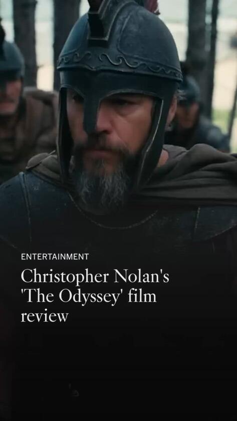
Tell me, Christopher Nolan, when did it first rosy-fingered dawn on you that your favorite type of protagonist — a tormented sinner-hero — was a specialty of the ancient Greeks? Millennia before Matthew McConaughey’s astronaut sobbed over abandoning his family and Cillian Murphy’s Robert Oppenheimer gasped that he had become the destroyer of worlds, the Greeks spun cautionary legends about Odysseus, the Trojan War tactician who outsmarted his own plan to sail smoothly home.
Nolan refuses to tremble before the canon. Grabbing mighty scissors, he cuts and rejiggers Homer and a bit of Virgil to transform these classical texts into his type of tale: one fixated on memory, self-identity, destructive genius and the slippage of time. As ever, it’s light on sex, heavy on wine-dark angst.
Once you endure its opening stretch — an expositional barrage with the pace of an obnoxious cop show — “The Odyssey” ascends as a monument to movie craft with shuddering ships, rough-hewn landscapes and practical monsters who snatch and grab men at random from above like giant skill cranes. Unlike in most mythological tales, the white Corinthian columns have been swapped out for brutal stone architecture. The Parthenon won’t be built for another 800 years; likewise, Athenian democracy is centuries away.
Nolan has anchored his “Odyssey” at the fall of the Bronze Age, a once-great era toppled by wealth-hoarding, diminished trade and climate catastrophes. Fearful of invading marauders, humankind has turned distrustful and stingy, ignoring Zeus’ command to show generosity toward the poor and foreign-born, a cornerstone of faith that would later be repurposed in the New Testament.
Share via
This Odysseus (Matt Damon) is both witness to and wrecking ball of the collapse. Not only does he steal, slaughter and pillage while expecting to be treated with kindness, but he’s also brainstormed the atomic bomb of his day: the Trojan horse, a deceitful invention planted into the sandy beaches of Troy that marks the decline of civilization like the Statue of Liberty in “Planet of the Apes.” Inside this claustrophobic wooden beast, Odysseus and his wild and bloodthirsty Greeks are crammed cheek-to-sandal so tightly that you can’t imagine how they’ll spring into action without first getting a massage. Outside and looking up at it, the pony seems to sneer.
“The Odyssey” is a saga with half a dozen detours and one destination, Ithaca, Odysseus’ kingdom. While he’s been fighting in Troy, his palace has been overrun by men who want to marry his faithful wife, Penelope (Anne Hathaway), and murder his helpless son, Telemachus (Tom Holland). Robert Pattinson’s oily suitor woos Penelope like a “Bachelorette” contestant: “It’s time to live again,” he urges her, certain that Penelope’s vengeful husband won’t come back. Forget that rose, dude, and run away.
Anne Hathaway and Tom Holland in the movie “The Odyssey.”
(Melinda Sue Gordon / Universal Pictures)
After 20 years away — 10 at war, 10 adrift — Odysseus is anxious to reclaim his kingdom. Or is he? Nolan floats a convincing psychological reason why this Odysseus subconsciously believes his duplicitous actions during the war deserve permanent exile from civilization. Although, as is the case with too much of Nolan’s storytelling, he wrongly thinks it’s more interesting to withhold Odysseus’ traumatic hang-up until the ending. The Greeks never tried to confuse the audience in the pursuit of suspense. They delivered their plots arrow-straight to make the dread sting.
Saddled with a silly black beard that eventually goes gray, Damon’s Odysseus is stubborn, overconfident and sacrilegious, but doesn’t bear that much resemblance to the conniving, hypocritical egotist of lore who fretted over his wife’s fidelity while seducing not one, but two, enchantresses, Calypso and Circe. Today’s viewers might demonize Odysseus’ erotic exploits; instead, they’ve been Damon-ized into something innately goodhearted.
The chasteness of Nolan’s version bugs me as it’s insulting he doesn’t trust audiences to grapple with this hero’s moral complexity — and I’m gut-sick that he’s probably right. Plus, it leaves Charlize Theron’s Calypso nothing to do but limply listen to (and medicate) Odysseus like a bored therapist reaching for the lithium. I was hoping for more zest from a blond wearing actual fishnets that could catch sardines.
At least Samantha Morton’s body-horror spin on the witch Circe is terrific. To punish his men for barging into her hut, she digs her fingers inside their skin like clay, remolding them into the swine she claims they are. Her outrage is one of the best ideas in the movie. Likewise, Lupita Nyong’o’s Helen is regal and formidable, but it’s a mistake to double-cast her as Helen’s twin sister, Clytemnestra. The whole reason thousands of men fought a war over the most beautiful woman alive is that there’s only one of them — unless undermining that excuse is the point. (In an aside, we’re told that Benny Safdie’s aloof Agamemnon, hiding under a try-hard scary helmet decorated with a golden spine, really waged it to break up Troy’s trade routes.)
Unlike in Homer or even “Clash of the Titans,” which showed the gods as toga-clad twits toying with mortal lives like action figures, they have little, if anything, to do in this plot. In Homer’s original verse, Athena is as fussy as a stage mother, showing up every few pages disguised as someone mortal to bless both Odysseus and Telemachus with live-action Photoshop filters that make them extra handsome. Here, Holland’s Telemachus gambles Athena is hiding inside half the people he meets until his father chides, “Don’t look for gods in men, you’ll just be disappointed.”
Instead, Nolan balances religion on the spear tip of doubt. The angry sea god Poseidon is reduced to rumors; mighty Zeus withheld to a few well-timed thunderclaps. Even Athena, if that genuinely is whom Zendaya is playing, isn’t that helpful, mostly staring at Odysseus in mute dismay. It’s possible to get to the end of “The Odyssey” and conclude that Nolan doesn’t believe in gods at all. To him, men must be proactive in their own demise. (I’m half-convinced, the way I don’t really swear by the zodiac but nevertheless stopped dating Libras.)
Composer Ludwig Göransson scores the breath-holding assault on Troy to drums that pound faster and faster on our nerves, as does our alarm that Odysseus’ troops aren’t the good guys. Occasionally, Göransson adds a lovely monotone layer of woodwinds or a keening chorus that sounds like the oldest song on Earth.
Conversely, during the talky Ithaca sequences, when the movie is rightly paranoid of losing our attention, the more modern heist-thriller music is flat-out obnoxious, especially in a scene where Odysseus lays out his ruse to infiltrate his house to John Leguizamo’s trusty goatherd, the most lovable man ever introduced throwing a puppy off a cliff. (No, really — it’s the movie’s only outright joke.)
Hoyte van Hoytema’s Imax-framed cinematography is assertive and present, rocking with the stormy waves and peering into the torch-lit darkness where the color palate is as starkly orange and black as an ancient Greek urn. Working with the special effects team, Van Hoytema cloaks the non-digital wizardry of the Cyclops and six-headed Scylla behind naturalistic camera movements and shadows so that, rather than drawing too much attention to themselves, the creatures just feel real. As gray and wrinkled as the bottom of a mummy’s foot, the Cyclops’ face is wonderfully askew, like he was stepped on by someone even bigger than him.
Nolan’s “Odyssey” engraves marvelous images onto the ancient oral poem. One of the most haunting shots is Odysseus sprinting out of Hades chased by an army of the dead who regret following him into battle. In turn, Nolan has sacrificed Odysseus himself to serve his own needs, scrapping the character’s prickly personality to Trojan-horse a message about how empires collapse.
Aghast at the ways of men, he’s dug his own Circe-like fingers into Homer to manipulate the tale into a moralistic “Oppenheimer” prequel. Even Odysseus seems to suspect as much. “Our mistakes will again be forgotten,” Odysseus predicts as the land he loves sails into the Dark Ages while he steers the helm. He’s done unforgivable wrongs. But in that moment, he’s right.
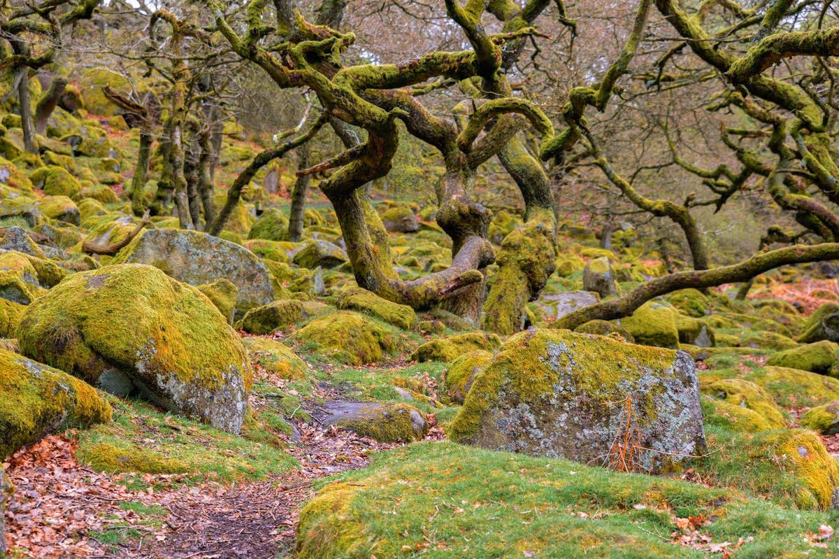
This beautiful woodland has been named among the best in Europe
This stunning woodland is located in Dartmoor(Image: Getty)
One of Britain’s last remaining ancient temperate rainforests has been recognised amongst Europe’s most enchanting forest trails this summer. Wistman’s Wood, nestled within Dartmoor, secured third place on the list thanks to its remote location, centuries-old dwarf oak trees and captivating woodland scenery.
Travel specialists at Avis examined lesser-known European forests with Perućica Rainforest, in Bosnia and Herzegovina, claiming the top position and Spain’s Otzarreta Forest taking second place.
Though Wistman’s Wood was the sole British entry, it’s easy to see why this breathtaking location earned its spot.
Located just 31 miles from Exeter Airport, Wistman’s Wood offers convenient access for those exploring Devon.
The forest’s remarkable 500-year-old dwarf oaks have been twisted into gnarled, moss-draped shapes through centuries of Atlantic weather, emerging from a carpet of lichen-clad granite rocks.
The area feels more like a concealed treasure than a typical woodland, offering rewards to those who value ambience, legend and untamed scenery over picture-perfect vantage points.
Writing on Tripadvisor, one recent guest to the woodland commented: “Stunning ancient woodland that will make you feel like you are in a fairytale. A must-visit place. A lovely and easy walk from a small car park opposite the Two Bridges Hotel.
“The woodland is hidden in the fields, you cannot see it from the main road. It roughly takes one hour to reach it from the car park. We visited in autumn on a rainy day, and still, it was magical. This is one of the most unique woodlands you can find in the UK.”
A further visitor enthused: “The wood was fun, the lichen hung like Hagrid’s beard. The sights were astonishing and we saw loads of cows and sheep. I would recommend it to everybody.”
One by one, the visitors descend through a tight tunnel cut through volcanic rock into the damp foundations of the Teatro Romano buried beneath Herculaneum, with the weight of 2,000 years of city above them. “This is a time machine,” the guide says, “and we are going back.” It is pitch black as film-maker Gianfranco Rosi’s camera finds torchlight catching the tourists’ transparent waterproof capes, making them appear like ghosts.
Released on the streaming platform Mubi this March, Rosi’s documentary Pompei: Below the Clouds threads a needle from classical antiquity to the present day. Presented in ashen black and white, without narration or interviews, it places the viewer inside the region surrounding Naples and leaves us there, each scene presenting a place and a moment in the area’s long history.
Illustration: Guardian Graphics
Naples is one of the oldest continuously inhabited cities in the world, and most visitors see only a fraction of it before boarding the Circumvesuviana at Porta Nolana and riding the narrow-gauge railway east to Pompei or Herculaneum. In Below the Clouds, Rosi does not alight there. He stays on the train, camera in hand, and traverses this seismic landscape – from the Sorrentine peninsula, crowned by Vesuvius in the east, to the lesser-known craters of the Phlegraean Fields in the west. The train, Rosi says, is “my time machine”. His lens draws us into the Naples most visitors never see.
As a film-maker myself, who has lived and worked in Naples for the past 15 years, I was inspired by Below the Clouds to make my own pilgrimage, and boarded the overcrowded, noisy trains I usually avoid.
Villa Oplontis ‘feels like a secret discovery’. Photograph: Alfio Giannotti/Alamy
Before the Circumvesuviana reaches the archaeological site of Pompei, it skirts the Bay of Naples, passing through a number of overlooked towns characterised by a stratification of history visible in the architecture. Drawing into the station of Torre Annunziata, Rosi holds the camera on the visible layers of the town’s history: diamond-patterned Roman brickwork cut from nearby volcanic quarries, Doric columns from an excavated Roman villa, and the still-lived-in mid-century housing blocks rising above them. That Roman villa is worth stopping for. Believed to have been built for Poppaea Sabina, the second wife of Emperor Nero, Villa Oplontis feels like a secret discovery. Its frescoes are almost untouched, its colonnade pristine, and on this day, as always, there was scarcely another soul in sight.
Back on the Circumvesuviana, I head east to Somma Vesuviana. A team from the University of Tokyo has been excavating here for decades, slowly uncovering the Villa Augustea, the imperial estate where the Emperor Augustus is believed to have died in AD14. It was not the great eruption of AD79 that buried the villa, but a later one in AD472. The archaeological treasures still buried across the region are so numerous that tomb raiders have long burrowed into the soft volcanic stone looking for loot to sell on.
A graffitied train on the Naples to Sorrento line stops at Pompei Scavi–Villa dei Misteri station. Photograph: PBW Pix/Alamy
A second train line, the Cumana, runs in the opposite direction. It departs from Montesanto station in central Naples and heads west, reaching Pozzuoli in 25 minutes. At the end of the line lies a working port city of 75,000 people living in the basin of one of the world’s most geologically active calderas (volcanic craters). The lore surrounding Vesuvius has long overshadowed the dangers posed by the Phlegraean Fields, which rumble daily beneath the city’s foundations.
Stepping off the train at Pozzuoli, I was hit by the pungent sulphuric smoke drifting over the port. I had timed my arrival for a simple lunch at Abbascio ù Mare (a local favourite serving fish landed from the boats that morning) before visiting the Macellum of Pozzuoli, a 2nd-century Roman market near the harbour. Here, I found the clearest record of what is known as bradyseism, the movement of magmatic fluid and gas beneath the surface of the Earth that lifts and lowers the land, sinking entire towns and raising them again centuries later. Halfway up the ancient columns, I spotted bands of small holes in the stone. These were bored by molluscs when the columns once stood metres below the bay. Rosi’s camera follows the phenomenon underwater, descending into the submerged ruins of nearby Baia, where robed marble figures stand upright on the seabed as shoals of fish drift over mosaics and between their feet.
Gianfranco Rosi’s documentary shows the submerged ruins of Baia, where robed marble figures still stand on the seabed. Photograph: Antonio Busiello/Alamy
Between east and west, at the intersection of the Circumvesuviana and the Cumana, lies Naples – known to the Greco-Romans as Neapolis (the new town) because it was new compared with Pompei and Baia. In the centre of the city, at the Museo Archeologico Nazionale di Napoli, Rosi films Maria, the museum’s archaeologist, deep in the storage vaults. This is what he calls the casaforte (the safe of memory) – shelf upon shelf of fragmented marble torsos, legs and busts, the overflow of 2,000 years of excavation. These artefacts are down here, Maria says, until it is their turn to return to the museum floor above – a mirror, Rosi suggests to me when we speak, of society’s own hierarchies. Like Rosi, I am obsessed with these perfectly formed marble figures, the survivors of catastrophe, that live in the galleries of the museum upstairs among the frescoes and bronzes, pulled from the same volcanic earth that buried thousands of people under Vesuvius.
Rosi juxtaposes the marble torsos with shots of dismembered ex-voto, small metal plates shaped like individual body parts. These are offerings, often left in churches or street shrines along with prayers to saints in exchange for bodily cures.
At the small church of Santa Maria Francesca delle Cinque Piaghe in the Quartieri Spagnoli, one of my favourite corners of the city, hundreds of ex-votos in the shape of pregnant women have been left for the saint of fertility. These practices, still very much alive today, speak to the Neapolitan impulse to marry the sacred and the profane.
A scene from Gianfranco Rosi’s documentary Pompei: Below the Clouds. Photograph: Venice Film Festival
Rosi’s film ends in an abandoned cinema somewhere along the train line, its seats destroyed, its screen partly intact. Into this ruin, Rosi projects clips from Roberto Rossellini’s Journey to Italy, a film about the past, playing in a ruin, in a city built on ruins, above a city that was itself once buried. Like a Chronovisor (a mythical 1950s invention that supposedly broadcast actual historical events), the cinema is where the present tense becomes the past even as you watch it. Just like Naples. Just like Below the Clouds.
By the end of the film’s nearly two-hour runtime, the viewer has made the same journey as those visitors descending into the foundations of the Teatro Romano in Herculaneum to behold and reflect on a civilisation buried mid-sentence. Below the Clouds insists, however, that this confrontation does not require a museum ticket. “We are already living inside the catastrophe,” says Rosi.
How often do you look down and wonder who created the path your feet are following? Or ask the cause of its curves and dips? Formed over thousands of years, paths form an “internet of feet” – a web of bridleways and hollow ways, drove roads and ridgeways, coffin tracks, pilgrimage trails and city pavements. Whether you’re hiking a National Trail or pottering along a National Trust footpath, there’s a good chance you’re following ancestral steps.
It’s thoughts like these that led me on a journey to track the evolution of British paths for my book, The Path More Travelled. Eleven thousand years ago ice age hunter-gatherers arrived from Europe’s heartlands, moving through the wilderness along broad “routeways”, that later widened to tracks when horses and then wheels were adopted in the bronze age. For more than 2,000 years, traffic moved no faster than the speed of a horse, until the internal combustion engine drove pedestrians off the road just over a century ago.
In search of the capillaries that gave life to every community in Britain, I revisited coast paths, tramped shepherds’ trails and followed the serpentine curls of rivers. Here are a few of my favourite paths that bring history to life.
Sweet Track, Somerset Levels
A replica of the neolithic Sweet Track though wetland at Shapwick Heath national nature reserve. Photograph: Craig Joiner Photography/Alamy
The hunt for prehistoric paths took me deep into the wetlands of the Somerset Levels, where the Sweet Track was discovered in 1970. Built nearly 6,000 years ago (3806BC) by early farmers who needed access to an island, the collapsed boardwalk was preserved in peat. But a short walk from the Avalon Marshes centre (with an excellent cafe and open-air museum), woodland paths explore Shapwick Heath nature reserve, where a replica section of the Sweet Track teeters through the reeds. Visitors can walk in single file along this narrow, timber causeway and imagine the world of the Neolithic pioneers who colonised Somerset’s reflective waterways long before they were drained and converted to farmland. For modern versions of the Sweet Track, visit the Norfolk Broads and Norfolk coast path, where stilted, planked boardwalks wend their way through reedbeds, salt marshes and swamp woodland known locally as alder carr.
Street of the Dead, Iona
The coffin road leading to Iona Abbey. Photograph: Charles Hutchison/Alamy
Writing this book led me to the far west of Scotland and the tiny island of Iona, where, after decades of tramping Britain’s paths, I walked for the first time along Sràid nam Marbh, the Street of the Dead. Across Britain, coffin roads, or corpse ways, were used by remote communities to convey their dead to cemeteries. Iona’s is no more than a few hundred metres in length, and most of it takes the form of a narrow, kinking lane leading from the ancient landing beach of Port nam Mairtear (Martyr’s Bay) to the site of a monastery founded in 563. Along this ancient road came the bodies of great Gaelic lords, bound for burial close to the monastery. For many, it’s a “thin place”, where the space between this world and the next narrows. You pass the ruins of an Augustinian nunnery established in around 1200, and the MacLean’s Cross, whose intricately carved floral and animal motifs and outstretched Christ captivated pilgrims. Then the abbey appears and the Street of the Dead, angling across the grass, the final section a short avenue of red granite slabs, sunken by the weight of time into the turf of the abbey precinct. There are very few roads in Britain where you can place your feet on to slabs that have been trodden by so many generations.
Bure Valley Path, Norfolk
The Bure Valley Path runs next to a vintage steam train line. Photograph: David Chapman/Alamy
One of my favourite walks traces the banks of the River Bure between the market town of Aylsham and the railway village of Hoveton. It’s a typical, gentle Norfolk valley of slow meanders, cascading willows, kingfishers and herons. It was like this 100 years ago, when huge timber sailing barges, wherries, used to glide silently upriver to Aylsham’s mills. Close to the river ran a steam railway line linking Hoveton and Aylsham. Today, the nine-mile Bure Valley Path is a shared walking and cycling route that follows the course of the old railway, now relaid as a narrow-gauge steam line, the Bure Valley Railway. Cycling the path is fun, but a superb walk awaits those who take the steam train from Hoveton to Aylsham then walk back towards Hoveton on the Bure Valley Path for about two miles, where a footpath on the left drops down to the waterside church of St Mary’s in Burgh-next-Aylsham. From here, riverside footpaths head downstream past white-painted watermills and old navigation locks while occasional steam locomotives contribute to the sylvan backdrop. At Coltishall, you can rehydrate at The Rising Sun, stroll along Anchor Street where wherries were built, and then return to the Bure Valley Path for the final two miles back to Hoveton. I know of no other walk so closely related to the eras of wind and steam.
The Ridgeway, Hertfordshire to Wiltshire
The Uffington White Horse. Photograph: John Henshall/Alamy
The Ridgeway runs for 87 miles from Ivinghoe Beacon high in the Chiltern Hills to the prehistoric stone circle at Avebury in deepest Wiltshire. On its rolling heights, you can walk back to the iron age, when formidable hill forts commanded the vales. The ghosts of warrior-farmers can be sensed most powerfully on the western end of the Ridgeway, where the chalky trail climbs past the ramparts of Uffington, whose banks and ditches – once braced with timber and chalk rubble – enclose an area twice the size of a football pitch. Right beside the fort, a 110-metre long white horse gallops across the down, cut deep into the turf during the late bronze age or early iron age. One mile to the west, the Ridgeway passes the chambered long barrow known as Wayland’s Smithy, which once contained the remains of 14 people dated to between 3590 and 3550BC. The Ridgeway’s knack of time travel has long appealed to writers and photographers, from Thomas Hardy and Richard Jefferies, to Richard Mabey and Fay Godwin, whose book The Oldest Road: The Ridgeway(1975), unravelled the path connecting deep history with a modern national trail.
Holloways, Surrey Hills
A holloway path at Holmbury St Mary in the Surrey Hills, near Leith Hill. Photograph: Matt Mawson/Getty Images
A holloway is a sunken path, an old way worn into the land by centuries of feet and hooves. Holloway walls can be almost vertical, cut back to raw rock and roots. Some are like ravines. Others are virtual tunnels, roofed with living trees. Some appear unexpectedly as gentle troughs in the landscape. They occur most dramatically in softer geologies like chalk, sandstone and greensand. Most are just a few minutes’ walk in length, but there are parts of the country where exploration will produce some very enjoyable clusters. There are three modest holloways right beside the White Horse of Uffington on the Ridgeway, cut perhaps in prehistoric times by cattle being moved from their winter quarters in the vale to the summer grasses of the high downs. In Holloway (2012), Robert Macfarlane wrote so poetically of a buried path in the Chideock valley of south Dorset that it’s become a cause of pilgrimage for those of us who look for these places. The Surrey Hills are laced with secretive holloways. Among my favourites are the sunken tracks on the greensand of Leith Hill and farther west, the old holloways of Hascombe Hill and Hydon’s Ball. It’s along these semi-subterranean trackways that you’re most likely to detect the steady plod of Saxon cattle. Or Hobbits.
The Mass Trespass Walk, Derbyshire
The path up William Clough on the Kinder Scout Mass Trespass walk. Photograph: Acorn 1/Alamy
The story of countryside access is written in the grit of Kinder Scout, whose frowning sandstone forms the highest point in the Peak District. In April, 1932, an excited gaggle of hikers climbed the footpath from the Derbyshire village of Hayfield up towards the brow of Kinder Scout, where they clashed with squads of gamekeepers intent on preventing public access to the moorland. Legislation followed and today the path up William Cloughis described on the National Trust website as the Kinder Scout Mass Trespass Walk. A vigorous eight-mile loop along the crags and back down to Hayfield, it offers the full Pennine repertoire in a single outing, from glittering reservoir to whispering moorland and monumental rocks. It includes Kinder Downfall cascade and a section of the Pennine Way, the earliest of Britain’s national trails. I walked the trail one blustery December day, ambushed by snow flurries and sunshine that spotlit Manchester like spilt crystals on the dark plain. I’ve climbed Kinder from many directions, but this is the route that tells the best story.
Nicholas Crane’s new book, The Path More Travelled, The Secret History of Britain’s Footpaths, is published by Weidenfeld & Nicolson (£25). To support the Guardian, order your copy at guardianbookshop.com. Delivery charges may apply.
Against its otherworldly scenes of ancient woodland, rustic bridges, snowdrops, and spiralling rivers, is a landscape that has attracted worldwide attention and featured in mega movies
This article contains affiliate links, we will receive a commission on any sales we generate from it. Learn more
The incredible UK area is made up of around 27,000 acres of ancient woodland(Image: Getty Images)
You don’t need a ticket to Hollywood to immerse yourself in movie magic, but simply a visit to a UK ancient woodland.
Situated between the Rivers Wye and Severn in Gloucestershire and on the Welsh border, is the enchanting Forest of Dean, one of England’s largest ancient woodlands. It’s made up of around 27,000 acres of towering forest, with a fairytale-like atmosphere, and was once a medieval royal hunting ground.
Rich in heritage, the woodland previously served as a vital timber supply for Tudor warships, before transforming into industrial terrain for coal mines, ironworks and tramways. It became England’s first National Forest Park in 1938, and today it’s a renowned area of spectacular beauty, set against a serene backdrop, that attracts hundreds of visitors for a day out or weekend escape.
There are scenic views of the River Wye from Symonds Yat Rock, the Clearwell Caves that are 100ft beneath the forest, winding cycling and walking trails, and an array of activities on offer.
Forest Ranger for Forest Holidays, Gerry O’Brien, exclusively told the Mirror: “The Forest of Dean was used where Harry and Hermione were camping in Harry Potter and the Deathly Hallows: Part 1.”
In the movie, Hermione also recalls memories of a holiday to the Forest of Dean with her parents. Symonds Yat and Coppett Hill, near Goodrich, were also featured in Harry Potter and the Deathly Hallows: Part 1, along with the forest pool where Harry retrieved Gryffindor’s sword.
Sharing an insight into the area, Gerry said: “If you’re looking down from Symonds Yat Rock, with the River Wye below you, you can look out over Copper Hill and on the other side, it’s the woodland where Harry Potter was filmed.”
But there’s another notable credit that the Forest of Dean holds. The Ranger at Forest of Dean added: “If you go to Symonds Yat East, it’s a little hamlet by the river, it’s beautiful and really picturesque. But you walk right past the house that was used in the Netflix series, Sex Education.
“It’s the red house, so all of that was filmed in and along the Wye Valley. There are a lot of hidden gems around the Forest of Dean. They’ve done alot of movies and TV work around the forest.”
Living amongst the Hollywood fame, the Forest of Dean has a diverse wildlife of free-roaming fallow deer, Pine martens, beavers, foxes and badgers, and is a favourite among birdwatchers. It’s also home to England’s largest wild boar population, earning it the nickname “wild boar capital of the UK”; yet visitors will be relieved to hear that they typically forage at dawn and dusk.
Thanks to its remarkable terrain, the ancient woodland has become a popular spot for those looking to explore nature, with its collection of winding footpaths and trails, tranquil lakes and ponds, nestled among the woodland. To experience this enchanting part of the world, many opt for a stay at Forest Holidays in the Forest of Dean, which offers a collection of lodges, cabins and treehouses, some with outdoor hot tubs to soak under the towering trees. Meanwhile the likes of Sykes Holiday Cottages and Holidaycottages.co.uk both also offer various stays in the region.
For something extra enchanting, the beautiful Puzzlewood woodland is a must-visit. Nestled in the heart of the Forest of Dean, it offers 14 acres of twisting, moss-covered trees, rustic wooden bridges, and snowdrops decorating the rugged ground, and is often tipped as being one of the region’s most beautiful spots.
This otherworldly feel has meant it’s also enjoyed some Hollywood spotlight, serving as a location for the likes of Star Wars: The Force Awakens, The Secret Garden, The Huntsman: Winter’s War, Doctor Who, Merlin, Netflix’s Our Planet and BBC’s Atlantis.
It was even named in Big 7 Travel’s ’50 Most Beautiful Places in the UK’ list for 2025 and again this year. Noting its characteristics that are used so widely as a film location, Big 7 Travel said: “Gnarled wooden trees, ancient wooden bridges and mossy mounds all create the perfect atmosphere for a fantasy novel setting.”
But that’s not all. Puzzlewood is also believed to have been an inspiration for Middle Earth in The Lord of the Rings series, including Mirkwood and the Old Forest. The magical woodland is also said to have influenced JK Rowling, for the Forbidden Forest featured in the Harry Potter franchise.
Do you have a travel story to share? Email webtravel@reachplc.com