rain

A road trip to Carrizo Plain, which blooms with spring colors

In summer, it’s too hot. And in rain, the muddy dirt roads threaten to swallow your car.

But if you can hit Carrizo Plain National Monument on a spring day when the hills and grasslands are green and a few wildflowers remain in the meadows — well, you’re winning. And you’ll be seeing a lonely, raw corner of California that few people ever find.

The monument is about 38 miles long and 17 miles wide — hard to miss, you’d think. But it lies along the San Andreas fault in the usually dry hills between Bakersfield and Santa Maria, far from Interstate 5 or U.S. 101, about 170 driving miles northwest of Los Angeles.

Signs warn motorists what's ahead in Carrizo Plain National Monument in San Luis Obispo County.

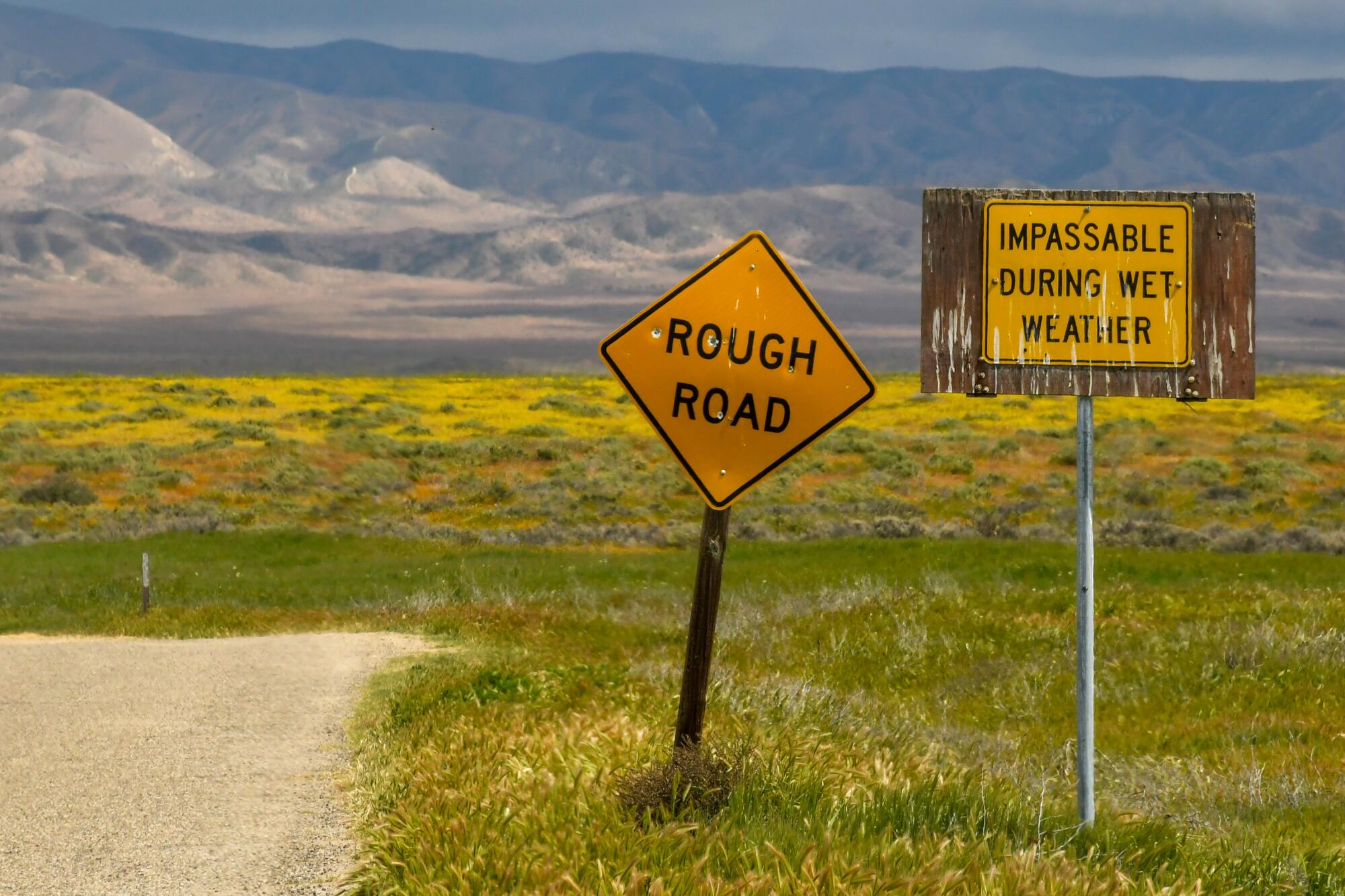
Signs warn motorists what’s ahead in Carrizo Plain National Monument in San Luis Obispo County.

(Christopher Reynolds/Los Angeles Times)

Within the monument, most of the roads are gravel or dirt, and there is no drinkable water, no food, no gas and spotty cellphone coverage. The education center and two semi-primitive campgrounds feature vault toilets.

It’s almost perfect, in other words, for repelling crowds. Yet it’s pretty good as the centerpiece of an overnight road trip probing small towns and back roads of the western San Joaquin Valley and eastern San Luis Obispo County.

If you happen to arrive Friday, Carrizo staffers and volunteers will be celebrating the 25th anniversary of the monument, which was created from former ranch land under President Clinton. (Free tours and refreshments will be offered at the event, which takes place from 10 a.m. to 1 p.m. at the Guy L. Goodwin Education Center.) But next week might be greener, because rain on the plain is probable Saturday and Sunday.

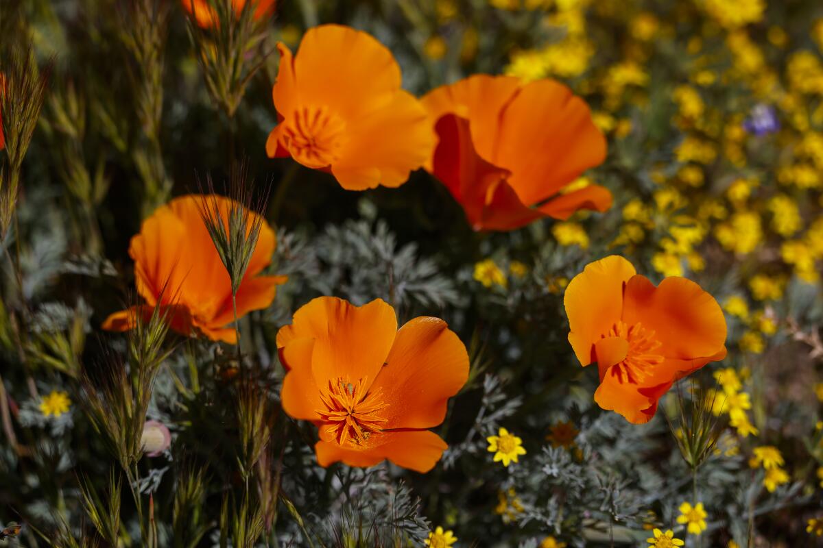
For many visitors, Carrizo’s big draw is wildflowers. The grasslands and hillsides act as a vast, uncluttered canvas for their colors, which typically bloom in March and last through April. But every year is different, especially in this era of climate change. This year, after unusually heavy rains in February, Carrizo Plain erupted in a dramatic bloom in March, attracting several hundred visitors per day.

In Carrizo Plain National Monument on a spring day, the grasslands were green and a few wildflowers remained in the meadows.

In Carrizo Plain National Monument on a spring day, the hills and grasslands were green and a few wildflowers remained in the meadows.

(Christopher Reynolds/Los Angeles Times)

By the time my wife and I arrived in the first days of April, the flowers were past their peak, but the hills were still green and many meadows popped with yellow, purple and blue. If I’m reading my wildflowers handbook right, these were tidy tips, Goldfields, Owl’s Clover, thistle sage, Valley Larkspur, coreopsis, phacelia and hillside daisies.

Meanwhile, the 3,000-acre Soda Lake, which lies dusty, crusty, dry and white in summer, still had some water in it. Imagine the salty lake beds of Mono Lake, the Salton Sea or Death Valley’s Badwater, but surrounded by green hills. It was startling — the opposite of an oasis in the desert.

To get there, we drove north on I-5 into the San Joaquin Valley, then veered west by way of State Routes 166, 33 and 58, pausing for gas at Maricopa (population: 984).

Within the monument, we rambled along Soda Lake Road, admiring windmills, an old ranch house now reserved for bats, and a few hills dotted with lazy cows. (The monument is run by the Bureau of Land Management, which allows grazing.)

Looking a little bit more closely, you realize that the monument is all but torn in two by the San Andreas fault. On Elkhorn Road, you remember that those mountains to the east (the Temblor Range) are slowly lurching to the southeast. Meanwhile the Caliente Range — those mountains just to the west — are lurching the opposite way. The “offset” is growing by about 1.5 inches per year — at least, until the next big quake.

A lone visitor stands at the edge of Soda Lake in Carrizo Plain National Monument.

A lone visitor stands at the edge of Soda Lake in Carrizo Plain National Monument.

(Christopher Reynolds/Los Angeles Times)

Slowly rolling through this scene, we spotted two critters scurrying along the roadside — fist-size creatures hopping on their back legs. These were probably giant kangaroo rats, a native species whose numbers have been growing since their listing as an endangered species in 1987.

We didn’t spot any blunt-nosed leopard lizards or San Joaquin Valley kit foxes (which eat giant kangaroo rats) but those species, too, are endangered and native to the area. Pronghorn antelope and Tule elk are out there, too, the experts say, along with California condors soaring overhead. We just saw crows, loitering on fence posts.

The Goodwin Education Center, the monument’s main gathering spot, is open Thursdays through Sundays, December through May. We looked at maps, got advice on where to go next and ate our sack lunches at a picnic table, marveling at those green slopes.

A San Joaquin kit fox is displayed at the Goodwin Education Center within Carrizo Plain National Monument.

A San Joaquin kit fox is displayed at the Goodwin Education Center within Carrizo Plain National Monument.

(Christopher Reynolds/Los Angeles Times)

In this long valley, scientists have found signs of Native campsites up to 10,000 years old — a hint of how much wetter this area once was. Not far from the education center is a short hike to Painted Rock, a protected site that includes Native pictographs on a horseshoe-shaped sandstone formation. The red, black and white images go back 100-4,000 years. (We didn’t see them. From March through May, visitors can see the pictographs only on Saturday guided tours. From July 16 through February, visitors can book self-guided tours.)

After lunch we nosed around nearby Soda Lake, exited the north end of the monument, joined State Route 58 and headed west over a series of whoop-de-doos — those rises and falls in the road that will help you defy gravity, if you take them fast enough.

One of them, I realize now, was the San Andreas fault itself.

Through all of this, we saw no more than 15 or 20 people, cars included. Continuing from State Route 58, we joined State Route 41, watched oak trees and vineyards pop up and multiply, continued into Paso Robles and spent the night.

On the return trip we lingered for an hour or two in Santa Margarita (population: 1,149), checking out the Porch Cafe, the Barn (antiques) and the Giddy Up vintage goods and gift shop, which operates in a blue Quonset structure known as the Rainbow Hut.

Holli Rae owns and runs the Giddy Up vintage goods and gift shop on El Camino Real in Santa Margarita.

Holli Rae owns and runs the Giddy Up vintage goods and gift shop on El Camino Real in Santa Margarita.

(Christopher Reynolds/Los Angeles Times)

“It’s just a sweet little town. So quiet,” said Holli Rae, a filmmaker and former Angeleno who opened the Giddy Up about two years ago. She moved north, she said, for “the nature, the animals, the deer, the birds. The creatures!”

Thanks to U.S. 101, we were home and grateful within three and a half hours.

Soon, we knew, summer will come and fry the Carrizo Plain until everything green is brown. Beginning June 1, in fact, the Goodwin Education Center will close for six months.

For a few more weeks, Angelenos, your window of opportunity is open.

If you go

Where to explore:
Check out the Carrizo Plain National Monument website or call the visitor center at (661) 391-6191. The recorded information line is (661) 391-6193. Also check the weather; most roads in the monument are dirt or gravel and can become impassable in rain.

Where to sleep:
Adelaide Inn, 1215 Ysabel Ave., Paso Robles; (805) 238-2770. This hotel, located near 24th Street and U.S. 101, includes a pool and children’s play area. Rates start at about $100.

River Lodge, 1955 Theatre Drive, Paso Robles; (805) 221-7377. This hotel, born as a motel in 1947, was reborn as a boutique property in 2024. It has 28 rooms, a patio restaurant (Ciao Papi) and an adult-only pool. It stands alongside U.S. 101, about 3 miles south of downtown Paso. Midweek rates often start at $149, often doubling on weekends.

Melody Ranch Motel, 939 Spring St., Paso Robles; (805) 238-3911. This is a throwback 1950s motel with a swimming pool, open May through September. From the start, it has had 19 rooms and a prime spot on Spring Street, the main artery of Paso Robles. Rates start at about $100. Most reservations are taken by phone, in person or through Expedia.

Where to eat:
Joe’s Place, 205 Spring St., Paso Robles; (805) 238-5637. Since 1995, this breakfast-and-lunch spot has been a local favorite for casual family meals.

The Porch Cafe, 22322 El Camino Real, Santa Margarita; (805) 438-3376. This all-day cafe (with beer and wine) stands along the main drag in sleepy little Santa Margarita.


Source link

Storm Dave set to approach UK bringing Easter weekend wind, rain and snow

There is a risk of significant travel disruption during what is predicted to be the busiest Easter weekend in four years for drivers.

Bridges could close and ferry services may be cancelled, with possible delays to planes, trains and buses.

Rough seas and large waves will bring dangerous conditions around the coasts.

Parts of north-west Scotland are also covered by a Met Office yellow warning for rain and snow.

At low levels, especially in the Western Isles and Skye, up to 50mm (2in) of rain could fall with the potential for flooding.

Meanwhile hills and mountains above 200m (650ft) are likely to see snow, with 5-10cm (2-4in) expected to accumulate, and a small chance of 20cm (8in) in a few places.

Coupled with the strong winds this could give blizzards, snowdrifts and very poor visibility on the roads.

Source link

Heavy rain, floods kill at least 45 people in Afghanistan, Pakistan | Weather News

At least 28 people are killed in Afghanistan and 17 in Pakistan after heavy rainfall causes severe flooding.

Heavy rain that has caused severe flooding and landslides has killed at least 45 people in Afghanistan and Pakistan over the past five days, authorities say.

Afghanistan’s National Disaster Management Authority (ANDMA) said on Monday that 28 people have been killed in the floods and 49 injured with more than 100 homes destroyed.

Recommended Stories

list of 3 itemsend of list

Most of the deaths in Afghanistan were reported in central and eastern provinces, including Parwan, Maidan Wardak, Daikundi and Logar, according to ANDMA.

The authority added in a statement that weather conditions remained “unstable” in parts of the country and there is a continued risk of more rain and flooding in some areas.

“In total, 1,140 families have been affected,” ANDMA said.

Police spokesperson Sediqullah Seddiqi told the AFP news agency a 14-year-old boy died after being struck by lightning in the northwestern province of Badghis.

He added that in the same province, three people had drowned while trying to gather driftwood to be used for heating.

At the same time in Pakistan’s Khyber Pakhtunkhwa province, which shares a border with Afghanistan, 17 people were killed and 56 wounded, the Provincial Disaster Management Authority said.

A man clears the rubble of his damaged house, collapsed after heavy rains in Bannu, Khyber Pakhtunkhwa province, in Pakistan March 30, 2026. REUTERS/Ehsan Khattak
A man clears the rubble of his house, which collapsed after heavy rains in Bannu, Khyber Pakhtunkhwa province, in Pakistan [Ehsan Khattak/Reuters]

Extreme weather

Heavy rainfall has continued to sweep across Afghanistan since Thursday, causing floods and landslides in multiple provinces.

The weather prompted the closure of several highways, according to officials in central and eastern Afghanistan. Further rains and storms are forecast for Tuesday.

Afghanistan’s National Disaster Management Authority has warned citizens to refrain from using “rivers and flooded streams, and follow the weather forecast seriously”.

In the central province of Daikundi, the local disaster management department said a five-year-old was killed when a roof collapsed. A woman was also killed in the same circumstances in the eastern province of Nangarhar, police spokesperson Sayed Tayeb Hamad said.

Afghanistan is vulnerable to extreme weather, particularly heavy rainfall and monsoon seasons, which trigger floods and landslides in remote areas with fragile infrastructure.

In January, flash floods and snowfall caused the deaths of at least 17 people and killed livestock.

Source link

Don’t want to miss Antelope Valley poppy bloom? Now there’s a forecast

Imagine waking up early, eager to peep dazzling carpets of brilliant orange flowers at the Antelope Valley California Poppy Reserve. Instagram posts promised a spectacle.

You drive to the reserve north of Los Angeles, but the rolling hills aren’t alive with color.

Bummer. The bloom is over.

Thanks to AI, and a local scientist, such disappointment may soon be a thing of the past.

This year, Steve Klosterman, a biologist who works on natural climate solutions, launched a “wildflower forecast,” powered by a deep-learning model, satellite imagery and weather data.

In a sense, Klosterman, of Santa Monica, developed the tool to meet his own need.

Last spring, the Midwest transplant was hankering to see some wildflowers. He assumed there was some online resource that offered predictions or leveraged satellite images.

“Surely, there must be something,” he recalled thinking. “But there was nothing.”

There are tools. The state reserve operates a live cam trained on one swath of land. Theodore Payne, a California native plant nursery and education center, runs a wildflower hotline, where people can call in and hear weekly recorded reports on hot spots.

“These are all essential resources,” Klosterman said. “At the same time, they’re limited.”

Klosterman isn’t green when it comes to plants. His PhD, at Harvard, focused on the timing of new leaves on trees in the spring and color change in the fall.

For a class project, a team he was part of built a website that predicted those leaf changes in the Boston area. It was a hit.

California poppies

California poppies bloom in Lancaster, near the state natural reserve, in mid-March.

(Kayla Bartkowski / Los Angeles Times)

To create the poppy bloom predictor, Klosterman turned to AI initially developed for medical imaging. He has harnessed it to instead analyze satellite images of the Antelope Valley.

The model scans 10-by-10-meter squares of land to determine whether poppies are present by their telltale orange color. (It also identifies tiny yellow flowers called goldfields.)

The model is trained on satellite images — which go back nine years — along with past weather data.

It then uses the current forecast, and recent flower status, to peer into the future.

If the mercury is going to hit 100 degrees and wind is picking up — and in previous years that led to withering flowers — that will guide the prediction.

Right now, the model can forecast five days out and is, as Klosterman puts it, “very much a work in progress.” It would be better, more powerful, if it had 100 years to learn from.

As more data are collected, it might someday be able to forecast a week or two out.

Right now, poppies are popping at the reserve in the western Mojave Desert.

It rained throughout the fall and into winter, and poppies need at least seven inches of rain to make a good showing, said Lori Wear, an interpreter at the reserve.

Snowfall in January seems to push them to another level, but that didn’t happen this season. So it’s a good bloom, but not extraordinary, she said.

Still, poppies — California’s state flower — blanket swaths of the protected land.

“It almost looks like Cheeto dust,” she said, “like somebody had Cheetos on their fingers and just smeared it on the landscape.”

Poppies here have typically peaked around mid-April, but variable weather in recent years has made it hard to predict, she said. Klosterman believes right now is likely the zenith.

Also blooming now: goldfields, purple grape soda lupine and owl’s clover. Wear described the latter, also purple, as looking like a “short owl with little eyes looking at you and a little beak.”

An SUV drives through the wildflower blooms

An SUV drives through blooms near the reserve. “It almost looks like … somebody had Cheetos on their fingers and just smeared it on the landscape,” said Lori Wear, an interpreter at the reserve.

(Kayla Bartkowski / Los Angeles Times)

On Sunday, Klosterman experienced the blooms for himself, using his technology as a guide.

It offers predictions in two forms. The first is the amount of the valley — shown in a satellite image — covered in poppies and goldfields, expressed as a percentage. The other is an overlay of orange and yellow splotches on the land.

The map showed a fairly high concentration of poppies near a stretch of Highway 138. He went there and, lo and behold, vibrant flowers awaited him. He sent proof: a smiling selfie in front of a sea of blossoms.

Klosterman’s tool may help answer arguably more complex questions than poppy or no poppy, such as a more precise understanding of the conditions the flowers need to thrive.

Experts know rain is key, but it’s more complicated than that.

Steve Klosterman in a field of California poppies.

Steve Klosterman takes a selfie in a field of California poppies.

(Steve Klosterman)

Heavy rain can supercharge invasive grasses, crowding out the blooms. Natives actually tend to do better after several years of drought, once invasives not adapted to the arid climate die out. That’s what led to an epic superbloom in 2017, Joan Dudney, an assistant professor of forest ecology at UC Santa Barbara, told The Times in 2024.

Klosterman wondered if the recent heatwave would desiccate them. But his model didn’t show that, and neither did his trip. So it’s possible other factors play a significant role in their persistence, such as length of day.

The model could also shed light on what could happen to the flowers as the climate warms. Will they migrate to the north? Will there be fewer blooms?

To game that out, Klosterman said you could invent and plug in a weather forecast with higher temperatures.

For now, Klosterman’s forecast is limited to the Antelope Valley. But if it expands to other areas, and other flower types, it could help people like Karina Silva.

Silva woke up at 5 a.m. last Wednesday to travel from her Las Vegas home to Death Valley National Park, hoping to beat the heat and the crowds to the superbloom.

But several hours later, she and her husband, David, were still trying to find it.

The hillside behind her was sprinkled with desert golds, but the display fell short of the riotous eruption of flowers posted on social media. The superbloom ended in early March, according to park officials.

“I was just thinking it was going to be this explosion of different colors,” Silva said by the side of the road overlooking Badwater Basin.

Source link