Hurricane Erin was expected to bring tropical storm conditions to North Carolina on Wednesday evening and Virginia on Thursday. Photo courtesy of the National Oceanic and Atmospheric Administration
Aug. 20 (UPI) — The outer bands of Hurricane Erin neared North Carolina’s Outer Banks on Wednesday evening, prompting the National Hurricane Center to issue warnings against swimming at most East Coast beaches.
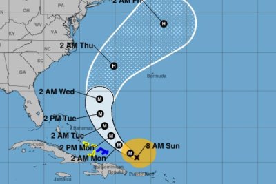
The Category 2 storm, described as “large” by the NHC, had maximum sustained winds of 110 mph, just shy of a Category 3 hurricane. The eye of the storm was located about 490 miles west of Bermuda and 245 miles south-southeast of Cape Hatteras, N.C., and was moving north at 14 mph, according to the NHC’s 8 p.m. update.
A storm surge warning was in effect for from Cape Lookout to Duck, N.C., while a tropical storm warning was in effect for Beaufort Inlet, N.C., to Chincoteague, Va., including Pamlico and Albemarle Sounds.
Bermuda was under a tropical storm watch.
“Erin is expected to produce life-threatening surf and rip currents along the beaches of the Bahamas, much of the east coast of the U.S., Bermuda and Atlantic Canada during the next several days,” the NHC said. “Beachgoers in those areas should follow advice from lifeguards, local authorities and beach warning flags.”
Forecasters warned weather conditions were expected to deteriorate along the Outer Banks late Wednesday into Thursday. Storm surge and large waves could cause beach erosion and make some roads impassible.
Tropical storm conditions were expected to reach the Virginia coast Thursday and farther north through early Friday.
The season’s first Atlantic hurricane reached Category 5 status Saturday morning, the highest classification, after rapidly intensifying overnight Friday, when it became a Category 1 hurricane, the year’s fifth named storm.
Erin dropped to a Category 4 and then a 3 overnight into Sunday, but regained Category 4 strength late Sunday before again losing strength.
There have been four named storms so far this season in the Atlantic. Tropical Storm Chantal caused major flooding in North Carolina but has been the only one of the four to make landfall in the United States this year.
The Atlantic hurricane season began on June 1 and ends on Nov. 30. The peak hurricane season runs from mid-August through September and into mid-October.
Ninety-three percent of hurricane landfalls along the U.S. Gulf Coast and the East Coast have occurred from August through October, the Weather Channel reported, citing data from the National Oceanic and Atmospheric Administration
Last year at this time, there had also been five named storms.
1 of 2 | Hurricane Erin dropped to a Class 3 hurricane as its outer rainbands pounded the Virgin Islands and Puerto Rico. Tracking by the National Hurricane Center
Aug. 17 (UPI) — Hurricane Erin weakened to a Category 3 storm with maximum sustained winds of 125 mph while the outbands pounded the Virgin Islands and Puerto Rico with gusty winds and heavy rains on Sunday.
The U.S. East Coast is forecast to have rough ocean conditions through the middle of the week, the National Hurricane Center said.
The storm is moving westerly at 14 mph and could affect the East Coast this week, the the NHC reported in an 8 a.m. EDT update.
The storm was located about 170 miles north-northwest of Puerto Rico and about 270 miles east of Grand Turk Island after passing the Leeward Islands on Saturday.
The season’s first Atlantic hurricane reached Category 5 status Saturday morning, the highest in the class, after rapidly intensifying overnight. It became a Category 1 hurricane on Friday, the years’ fifth named storm.
Erin dropped to a Category 4, and then 3 overnight into Sunday, but remained a major hurricane.
“Since the large-scale environment is expected to be favorable for about another day, re-strengthening is possible during that time period,” NHC forecaster John Cangialsi said in a discussion. “However, it should be noted that predicting the intensity evolution from internal dynamics are challenging, and models often provide Little reliability in their solutions.”
There is a tropical storm warning for the Turks and Caicos Islands and a tropical storm watch is in effect for the southeast Bahamas.
The storm was skirting Puerto Rico rather than hitting it directly.
Erin’s motion is expected to decrease in forward speed on Sunday, followed by a gradual turn to the north on Monday and Tuesday, NHC said.
On the forecast track, Erin’s core is projected to pass to the east of the Turks and Caicos Islands and southeastern Bahamas on Sunday and Monday.
By Thursday, the storm is forecast to be a few hundred miles west of Bermuda and just outside the big tracking cone. Erin is then forecast to travel north hundreds of miles from the East Coast.
Erin’s outer bands will produce rainfall of 3 to 6 inches across the Virgin Islands and Puerto Rico, with isolated totals of up to 8 inches. “Locally considerable flash and urban flooding, along with landslides or mudslides, are possible,” NHC said.
Also, swells will affect those places, as well as Hispaniola and the Turks and Caicos Islands, during the next couple of days, the agency said.
“Erin is expected to produce life-threatening surf and rip currents along the beaches of the Bahamas, much of the East Coast of the U.S., Bermuda, and Atlantic Canada during the next several days,” Cangialsi said.
He said interests along the North Carolina and mid-Atlantic coasts, as well are Bermuda “should monitor the progress of Erin as there is a risk of strong winds associated with the outer rainbands during the middle of next week.”
There have been four named storms so far this season in the Atlantic. Tropical Storm Chantal caused major flooding in North Carolina but has been the only of the four to make landfall in the United States this year.
The Atlantic hurricane season began on June 1 and ends on Nov. 30. The peak hurricane season goes from mid-August through September and into mid-October.
Ninety-three percent of hurricane landfalls along the U.S. Gulf Coast and the East Coast have occurred from August through October, the Weather Channel reported in citing data from the National Oceanic and Atmospheric Administration
Last year at this time, there also had been five named storms.
The hills of the Scottish Highlands were still in sight when the cry went up: “Whale!” And there it was, a humpback on the port side of the Caledonian MacBrayne ferry, blasting a great cloud of mist from its blowhole, then with a farewell flick of its tail, disappearing into the Atlantic. On other voyages you may see glorious sunsets, rare migratory birds, ruined castles and historic lighthouses. Unlike the classic road trip or the great railway journey, however, the humble ferry rarely makes it to anyone’s bucket list. They are a means to an end, only chosen by necessity. And yet, the UK has some of the best and most exhilarating voyages within its borders. From exciting river crossings to island odysseys that test the mettle of the best sea captains, these boat journeys can be the high point of any trip.
Whale-watching on the way from Cornwall to the Isles of Scilly
Starting from Penzance’s South Pier, in sight of St Michael’s Mount, the crossing to St Mary’s is the indispensable highlight of any trip to the Isles of Scilly. The gas-guzzling, climate-clobbering helicopter doesn’t even approach the magic of this ship and its three-hour voyage into the Atlantic Ocean. Penzance bursts with nautical heritage; many of its remarkable number of pubs have existed since the days of Captain Kidd and Francis Drake. Once aboard the Scillonian (built in Appledore, Devon, in 1977), find a position with a view to the starboard to glimpse Land’s End on departure, then keep a lookout for wildlife. Dolphins and whales are sighted regularly on the voyage. Birdlife includes gannets, Manx shearwaters and puffins. Watch out for bird feeding frenzies, which may attract the attention of bluefin tuna (the half-ton fish can leap clear of the water and numbers are rising fast). Other potential highlights include fin whales, the planet’s second largest animal after the blue whale – with several sightings in 2024. A day return on the Scillonian III is £35.Woodstock Ark, a secluded cabin near Penzance South Pier, sleeps two, from £133 a night. Star Castle Hotel, close to the Scillonian’s arrival point on St Mary’s, has great food and superb views; doubles with dinner from £245.
A tugboat tow on the River Dart in Devon
There has been a ferry across the River Dart since the 14th century. Photograph: Candy Apple Red Images/Alamy
Dartmouth has a huge heritage of sailing and boats, and the lower ferry across the mouth of the River Dart is an absolute classic. The best approach is on the steam railway from Paignton, which brings you into what was once the Great Western Railway’s imposing Kingswear station on the east bank of the river. Alternatively, you could walk to Kingswear on the South West Coast Path from Brixham (a 10-mile yomp). There has been a ferry here since the 14th century and the latest incarnation is a barge with room for eight cars towed by a tugboat. The crossing is short but memorable, the flanks of the steeply wooded valley looming over a fast-moving tidal river that froths around the barge as it picks its way through a busy shipping lane. Landing is right in town, next to the blue plaque for John Davis, one of the great sea dogs of Devon, who searched for the Northwest Passage and died at the hands of pirates near Singapore in 1605. If the crossing has whetted the appetite, walk upriver along the historic waterfront to the Upper Dart ferry, another interesting boat. Originally a floating platform linked to cross-river chains that were pulled by horses, today it’s a diesel-electric paddle engine combined with cables that can manage about 18 cars. The Lower Dart Ferry costs £5 return for a foot passenger; car and passengers £14 return. Ferryside apartment next to the ferry in Kingswear sleeps four, from £533 for three nights. Further away, Dartington Hall, once Britain’s leading progressive school, is now a top arts centre, offering wonderful gardens and accommodation, withdoubles from £103 B&B.
An exhilarating passage from Berneray toHarris in the Outer Hebrides
A Caledonian MacBrayne ferry docked at Berneray. Photograph: Pearl Bucknall/Alamy
Scotland is blessed with many memorable ferry routes, but none surpasses the short voyage from Berneray to Leverburgh on Harris. A hop of just nine nautical miles and taking an hour, it crosses the shallow Sound of Harris, which is strewn with deadly rocks, dangerous tidal currents and frequent mists. Before GPS, it was a rule that the captain would turn back if he couldn’t see two buoys ahead, and occasionally the ship would slither on to a sandbank and have to stay there until the tide lifted her off. These days it remains an exhilarating passage, weaving between dozens of jagged hazards with evocative names such as Drowning Rock and the Black Curran. Listen for the ghostly cries of seals on the larger islets, and look out for a majestic white-tailed sea eagle. The Caledonian MacBrayne ferry costs £4.70 one way for a foot passenger. Camping at Balranald on North Uist is highly recommended (tent £14), or try 30 Backhill, a restored thatched stone croft on Berneray, from £535a week.
Crossing Harwich harbour from Suffolk to Essex
Passengers boarding the Harwich harbour ferry in Felixstowe, Suffolk. Photograph: Geog Photos/Alamy
As a shortcut at the end of the Suffolk coastal path, the ferry from Landguard Fort near Felixstowe to Harwich offers great panoramas of the harbour formed by the rivers Orwell and Stour. You’re likely to spot some of the planet’s largest container ships and a Thames barge. Alternatively, embark at Shotley Gate, the tip of the narrow and beautiful Shotley peninsula that separates the two rivers – the walk down the Orwell from Ipswich is particularly picturesque, taking in Pin Mill. Harwich old town is also well worth exploring, with some beautiful period buildings including the Electric Cinema, opened in 1911. The Harwich Harbour Ferry connects Felixstowe and Harwich (tickets £6 one way), and Harwich and Shotley (£4.80); it runs from April to October. The Alma Inn is a gorgeous Grade II-listed pub in old Harwich, with doubles from £90 B&B.
A hand ferry across the River Wye in Herefordshire
The barman at the pub in Symonds Yat hauls the ferry across the River Wye. Photograph: Paul Weston/Alamy
There cannot be many ferries that only run when the barman is free, but this classic crossing requires the pump-puller at the Saracens Head in Symonds Yat to shut up shop for a few minutes and haul half a dozen passengers across the River Wye using an overhead cable. Despite some deplorable environmental mismanagement upstream, the river here remains a beautiful sight. On the far bank, take the lane north to another good pub, Ye Old Ferrie Inn. Their ferry drops you on a footpath that heads up through the woods for the fine views along the curving river from the Symonds Yat rock itself. These crags were visited in 1770, by schoolmaster William Gilpin, who had an eye for untamed landscapes, triggering a revolution in the appreciation of views and nature that we still benefit from today. Alternatively, walk downriver and cross at the beautiful Biblins suspension bridge. Both Symonds Yat ferries cost £2 for adults. The Saracens Head occupies a lovely riverside location, with doubles from £135, B&B.
Swivel from Glenelg to the Isle of Skye in the Inner Hebrides
The Glenelg to Skye ferry is a fun alternative to the modern bridge. Photograph: John Bracegirdle/Alamy
You may, of course, choose to take the bridge to Skye, but for a real Hebridean treat take the original ferry across the 500-metre-wide Kyle Rhea straits. This is the last manually operated turntable ferry in the world (built in Troon in 1969), carrying just six cars and 12 people on a five-minute voyage. Due to strong tidal currents running at up to nine knots and frequently windy conditions, the designers came up with the ingenious solution of a turntable to allow vehicles to disembark safely. Saved by a local campaign in 2006, it has now become a vital part of the Skye experience. The Isle of Skye ferry from Glenelg costs£3 for foot passengers, and £20 for a car (with up to four passengers) one way. Sykes Cottages has a number of properties on Skye, including Beaton’s traditional thatched croft, from £457a week.