Guantanamo Bay

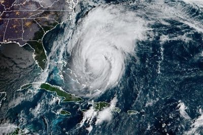
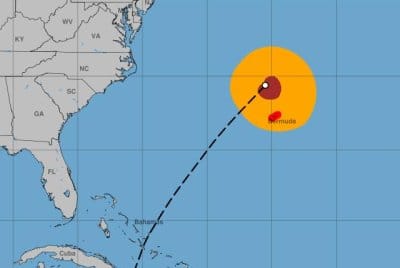
Weakened Hurricane Melissa passing north of Bermuda

Hurricane Melissa was passing norther of Bermuda early Friday. Image courtesy NOAA

Oct. 31 (UPI) — Hurricane Melissa, now a weakened Category 1 storm, was passing north of Bermuda early Friday after battering the Caribbean over the past few days, forecasters said.

Forecasters said Melissa was at its nearest approach to Bermuda, where a hurricane warning was in effect and hurricane-force winds were being felt.

The eye of Melissa was about 150 miles north-northwest of Bermuda, the National Hurricane Center said in its 2 a.m. EDT update.

It had maximum sustained winds of 90 mph, a drop of 15 mph from 8 p.m. Thursday. The storm was moving northeast at 40 mph. Earlier in its life cycle, the storm was largely stationary, moving at about 2 mph as it made its way toward a Jamaican landfall Tuesday.

Forecasts had indicated that the storm would pick up speed as it moved away from the Bahamas. It was forecast to become a strong extratropical cyclone near the southeastern tip of Newfoundland on Friday.

Hurricane-force wind gusts were being reported early Friday on Bermuda, as the storm made its closest approach. The outer bands of Melissa could pour an additional 1 to 2 inches of rain over Bermuda through early Friday, while a brief period of heavy rain was considered possible for the southern Avalon Peninsula of Newfoundland on Friday night.

Melissa made landfall in Jamaica on Tuesday at about 1 p.m. as a powerful Category 5 storm, with estimated maximum sustained winds of 185 mph. It was the strongest direct hit on Jamaica since records have been kept in the Atlantic basin. It was also the first storm to make landfall in the Caribbean this season.

The storm lost some strength as it traveled over Jamaica’s western mountains, but maintained major hurricane status as it headed for Cuba. It remained a hurricane when it reached the Bahamas.

Melissa is the 13th named storm and fifth hurricane of the season. The other Category 5 storms in the Atlantic this season have been Erin and Humberto.

In September 2019, Hurricane Dorian had maximum sustained winds of 185 mph and devastated the Bahamian islands, including the Abaco Islands and Grand Bahama, as a Category 5 storm.

The all-time highest sustained wind speed recorded in the Atlantic was Hurricane Allen at 190 mph in August 1980 over the Yucatan Peninsula before weakening to a Category 3 when it struck South Texas.

The most destructive Category 5 storm in the United States was Hurricane Andrew in August 1992, causing $27.3 billion in damage. Hurricane Michael, also a Category 5 storm, struck the less-populated Florida Panhandle in October 2018.

Hurricane Gilbert struck Jamaica in 1988 as a Category 3 storm.

Source link

Category 2 Hurricane Melissa to pass Bermuda on Thursday night

Hurricane Melissa was not projected to make direct landfall on Bermuda but is still expected to bring dangerous conditions. Photo courtesy NOAA

Oct. 30 (UPI) — Hurricane Melissa, now a Category 2 storm, was heading toward Bermuda on Thursday evening after battering the Caribbean over the past few days, forecasters said.

Forecasters said Melissa was forecast to pass Bermuda, where a hurricane warning is in effect, on Thursday night.

The eye of Melissa was about 260 miles west-southwest of Bermuda, the National Hurricane Center said in its 8 p.m. EDT update.

It had maximum sustained winds of 105 mph, and was making its way northeast toward Bermuda at 21 mph. Earlier in its lifecycle, the storm was largely stationary, moving at about 2 mph as it made its way toward a Jamaican landfall Tuesday.

Forecasts indicate the storm would pick up more speed as it moves away from the Bahamas. It was forecast to pass to the northwest of Bermuda on Thursday night and should become a strong extratropical cyclone near the southeastern tip of Newfoundland on Friday.

The outer bands of Melissa could pour an additional 1 to 2 inches of rain over Bermuda through Thursday night, while a brief period of heavy rain was considered possible for the southern Avalon Peninsula of Newfoundland on Friday night.

Melissa made landfall in Jamaica on Tuesday at about 1 p.m. as a powerful Category 5 storm, with estimated maximum sustained winds of 185 mph. It was the strongest direct hit on Jamaica since records have been kept in the Atlantic basin. It was also the first storm to make landfall in the Caribbean this season.

The storm lost some strength as it traveled over Jamaica’s western mountains, but maintained major hurricane status as it headed for Cuba. It remained a hurricane when it reached the Bahamas.

Melissa is the 13th named storm and fifth hurricane of the season. The other Category 5 storms in the Atlantic this season have been Erin and Humberto.

In September 2019, Hurricane Dorian had maximum sustained winds of 185 mph and devastated the Bahamian islands, including the Abaco Islands and Grand Bahama, as a Category 5 storm.

The all-time highest sustained wind speed recorded in the Atlantic was Hurricane Allen at 190 mph in August 1980 over the Yucatan Peninsula before weakening to a Category 3 when it struck South Texas.

The most destructive Category 5 storm in the United States was Hurricane Andrew in August 1992, causing $27.3 billion in damage. Hurricane Michael, also a Category 5 storm, struck the less populated Florida Panhandle in October 2018.

Hurricane Gilbert struck Jamaica in 1988 as a Category 3 storm.

Source link

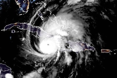
Cat. 4 Melissa regaining strength as it heads for Cuba

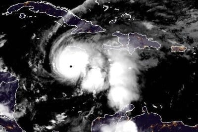
Hurricane Melissa was heading for Cuba late Tuesday as a Category 4 storm. Image by NOAA

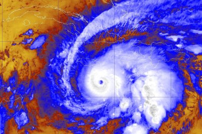
Oct. 28 (UPI) — Hurricane Melissa was regaining strength Tuesday night as it was taking aim at Cuba after battering Jamaica throughout the day, forecasters said.

The eye of Melissa was situated about 110 miles southwest of Guantanamo, Cuba, and 300 miles south of the central Bahamas, the National Hurricane Center said in its 11 p.m. EDT update. It was moving northeast at 9 mph.

Melissa had maximum sustained winds of 130 mph, making it a Category 4 storm, and significantly weaker than the Category 5 storm when it hit Jamaica.

It had lost strength as it traveled over Jamaica’s western mountains, but forecasters said it appeared to be strengthening.

Melissa made landfall as a powerful major hurricane, the strongest direct hit on Jamaica since records have been kept in the Atlantic basin. It was also be the first storm to make landfall in the Caribbean this season.

Melissa is anticipated to make a second landfall along Cuba’s southeastern coast soon, while still maintaining major hurricane strength. It’s also expected to remain a hurricane when it reaches the Bahamas. Bermuda also could be threatened.

“Melissa is expected to continue to strengthen until it reaches Cuba in a few hours, and it is expected to make landfall there as a very dangerous major hurricane,” NHC forecaster John Cangialosi said in a late Tuesday discussion on the storm.

“Melissa is still expected to be a powerful hurricane when it moves through the Bahamas and near Bermuda.”

Catastrophic flash flooding and landslides in parts of southern Hispaniola and Jamaica were expected through early next week.

A hurricane warning was in effect for the Cuban provinces of Granma, Santiago de Cuba, Guantanamo and Holguin; and the southeastern and central Bahamas.

A hurricane watch was in effect for Bermuda.

There was a tropical storm warning for Jamaica, Haiti, Turks and Caicos Islands and the Cuban province of Las Tunas.

Hurricane-force winds extended up to 30 miles from the center, and tropical-storm-force winds extended outward to 195 miles.

Rainfall of 15 to 30 inches through Wednesday was forecast for portions of Jamaica and an additional 6 to 12 inches for southern Hispaniola, which includes Haiti and the Dominican Republic. Jamaica is to get a local maximum of 40 inches, the NHC said.

“Catastrophic flash flooding and numerous landslides are likely,” the NHC said.

Cuba is expected to receive rainfall of 10 to 20 inches, with local amounts up to 25 inches, into Wednesday, “resulting in life-threatening and potentially catastrophic flash flooding with numerous landslides,” the NHC said.

Over the southeastern Bahamas, rainfall is forecast to total 5 to 10 inches into Wednesday with flash flooding in some areas.

Life-threatening storm surge heights could reach 9 to 13 feet above ground level, near and to the east of where the center of Melissa makes landfall and are expected to be accompanied by large and destructive waves, NHC said.

Along the Cuban coast late Tuesday and Wednesday, there is a potential for a significant storm surge of 7 to 11 feet.

And in the southeastern Bahamas and Turks and Caicos Islands, there is the possibility of a storm surge of 4 to 6 feet.

Melissa is the 13th named storm of the season and fifth hurricane. The other Category 5 storms in the Atlantic have been Erin and Humberto.

In September 2019, Hurricane Dorian had maximum sustained winds of 185 mph and devastated the Bahamas islands, including Abaco Islands and Grand Bahama, as a Category 5 storm.

The all-time highest sustained wind speed was Hurricane Allen at 190 mph in August 1980 over the Yucatan Peninsula before weakening to a Category 3 when it struck South Texas.

The most destructive Category 5 storm in the United States was Hurricane Andrew in August 1992, with $27.3 billion in damage. Hurricane Michael, also a Category 5 storm, struck the less populated Florida Panhandle in October 2018.

The United States is not threatened this time.

Hurricane Gilbert struck Jamaica in 1988 as a Category 3 storm.

Source link

U.S. evacuates Guantanamo Bay as Hurricane Melissa slams Caribbean

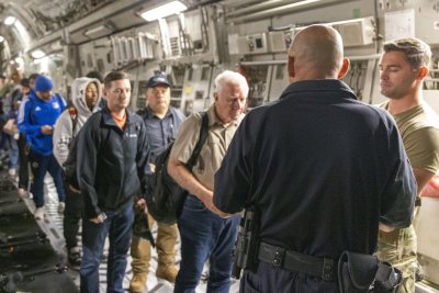
1 of 2 | Naval Station Guantanamo Bay evacuated non-essential personnel from the base Saturday ahead of Hurricane Melissa. Photo by U.S. Navy

Oct. 28 (UPI) — The U.S. military has evacuated about 1,000 nonessential residents from the U.S. Navy base at Guantanamo Bay in anticipation of the powerful Hurricane Melissa advancing through the Caribbean Tuesday.

More than 1,000 non-essential military personnel, along with their families and pets flew to the Naval Air Station Pensacola in the days leading up to the hurricane’s arrival, USNI News reported.

To prepare for the influx of military personnel, Pensacola’s Fleet and Family Support Center opened its Emergency Family Assistance Center on Saturday to connect them with lodging, essential supplies and other resources, according to a Navy press statement. Moving the non-essential personnel to Pensacola will minimize operations during the hurricane and make recovery easier after it passes, according to the statement. .

“The sailors and civilian employees here are dedicated and adaptable, making sure they accomplish our Navy mission -and right now that’s taking care of our Navy family from Guantanamo Bay,” NAS Pensacola Commanding Officer Capt. Chandra Newman said in the statement.

The remaining 3,000 residents of the base moved into temporary shelters in a community gym and a new K-12 school, The New York Times reported. Officials instructed residents to bring their own bedding along with coolers full of enough food and water to last three days, the paper reported.

Hurricane Melissa is the world’s strongest storm seen so far this year. It left at least seven people dead after it made landfall in Jamaica earlier on Tuesday.

Although the center of the storm has passed over Jamaica, the National Hurricane Center warned Tuesday evening of heavy rain “catastrophic flash flooding” and numerous landslides. Melissa is expected to move away from western Jamaica Tuesday evening, late moving to southeastern Cuba “as an extremely dangerous major hurricane,” according to the center.

Melissa is currently a Category 4 hurricane with maximum sustained winds near 145 mph.

Source link

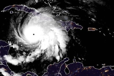
Slow-moving Cat. 5 Hurricane Melissa nears Jamaica landfall

1 of 2 | Hurricane Melissa, a strong Category 5 storm, was expected to make landfall in southern Jamaica early Tuesday. Photo courtesy of NOAA

Oct. 27 (UPI) — Melissa, a strong Category 5 hurricane, neared landfall on the Caribbean island nation of Jamaica early Tuesday, where three people were already dead and amid fears of a humanitarian crisis.

The Dominican Republic, Haiti, Cuba and the Bahamas were to be later threatened with powerful winds, rainfall and storm surge.

The storm was expected to move near or over Jamaica’s southern coast Tuesday — the first hurricane to make landfall in the Caribbean this season.

The island, which has 2.8 million residents, was already experiencing damaging winds and heavy rainfall, threatening catastrophic and life-threatening flash flooding and landslides. The Ministry of Health and Wellness has reported three deaths and nearly 15 people injured while preparing for the storm.

The hurricane was situated about 115 miles southwest of Kingston, Jamaica, and about 290 miles southwest of Guantanamo, Cuba, the National Hurricane Center said in its 2 a.m. EDT update. It was moving north-northeast at 5 mph.

Melissa’s maximum sustained winds of 175 mph have not changed since the 2 p.m. update on Monday. Hurricanes are designated as the highest class when they reach 157 mph.

When Melissa makes landfall as a powerful major hurricane, it will be the strongest direct hit for the island since records have been kept in the Atlantic Basin.

“Catastrophic flash flooding and numerous landslides are expected through Tuesday,” NHC forecaster Richard Pasch said in a late Monday discussion about Jamaica. “The eyewall’s destructive winds may cause total structural failure, particularly in higher elevations, leading to widespread infrastructural damage, prolonged power and communication outages and isolated communities.”

The storm became a hurricane Saturday morning and was upgraded to a Category 3 major hurricane by Saturday night, then a Category 4 on Sunday morning and a Category 5 on Monday morning.

On Tuesday night or Wednesday, Melissa is anticipated to make a second landfall along Cuba’s southeastern coast, while still wielding major hurricane strength. It’s also expected to remain a hurricane when it reaches the Bahamas. Bermuda also could be threatened.

“After reaching Jamaica, a combination of land interaction and increasing southwesterly shear should cause some weakening, although Melissa is still forecast to be a major hurricane when it reaches Cuba,” NHC forecaster Jack Beven said in an earlier discussion.

“Once over the Atlantic, stronger shear should cause more substantial weakening, and Melissa is expected to become extratropical by the end of the forecast period as it interacts with a large baroclinic low over the north Atlantic.”

Catastrophic flash flooding and landslides in parts of southern Hispaniola and Jamaica were expected through early next week.

A hurricane warning was in effect for all of Jamaica; the Cuban provinces of Granma, Santiago de Cuba, Guantanamo and Holguin; and the southeastern and central Bahamas.

Hurricane watches were in effect for the Turks and Caicos Islands.

There was a tropical storm warning for Haiti and the Cuban province of Las Tunas and the Turks and Caicos Islands.

Hurricane-force winds extended up to 30 miles from the center, and tropical-force winds tended outward to 195 miles.

Rainfall of 15 to 30 inches through Wednesday was forecast for portions of Jamaica and an additional 6 to 12 inches for southern Hispaniola, which includes Haiti and the Dominican Republic, and Jamaica, with a local maximum of 40 inches, the NHC said.

“Catastrophic flash flooding and numerous landslides are likely,” NHC said.

Cuba is expected to receive rainfall of 10 to 20 inches, with local amounts up to 25 inches, into Wednesday, “resulting in life-threatening and potentially catastrophic flash flooding with numerous landslides,” NHC said.

Over the southeastern Bahamas, rainfall is forecast to total 5 to 10 inches into Wednesday with flash flooding in some areas.

Life-threatening storm surge heights could reach 9 to 13 feet above ground level, near and to the east of where the center of Melissa makes landfall and are expected to be accompanied by large and destructive waves, NHC said.

Along the Cuban coast late Tuesday and Wednesday, there is a potential for significant storm surge of 7 to 11 feet.

And in the southeastern Bahamas and Turks and Caicos Islands, there is the possibility of storm surge of 4 to 6 feet.

Melissa is the 13th named storm of the season and fifth hurricane. The other Category 5 storms in the Atlantic have been Erin and Humberto.

In September 2019, Hurricane Dorian had maximum sustained winds of 185 mph and destroyed the Bahamas islands, including Abaco Islands and Grand Bahama, as a Category 5 storm.

The all-time highest sustained measure was Hurricane Allen at 190 mph in August 1980 over the Yucatan Peninsula but weakened to a Category 3 when it struck south Texas.

The most destructive Category 5 storm in the United States was Hurricane Andrew in August 1992, with $27.3 billion in damage. Hurricane Michael, also a Category 5 storm, struck the less populated Florida Panhandle in October 2018.

The U.S. is not threatened this time.

Hurricane Gilbert struck Jamaica in 1988 as a Category 3 storm. The island could be battered for several hours as the eyewall moves slowly.

Source link

‘Seek shelter now,’ forecasters warn as Cat. 4 Melissa nears Jamaica

1 of 3 | Hurricane Melissa, a Category 4 storm, was expected to make landfall in Jamaica on Tuesday morning. Photo courtesy of NOAA

Oct. 27 (UPI) — Forecasters are warning residents of Jamaica to “seek shelter now,” as Melissa, a Category 4 hurricane, was making its way toward the Caribbean island nation early Monday.

The storm was expected to make landfall along Jamaica’s southern coast on Tuesday morning, but the National Hurricane Center reported that the island is already experiencing damaging winds and heavy rainfall that will cause catastrophic and life-threatening flash flooding and landslides.

The hurricane, a Category 4 storm, was located about 130 miles south-southwest of Kingston, Jamaica, and about 315 miles south-southwest of Guantanamo, Cuba, the National Hurricane Center said in its 8 p.m. EDT update.

It had maximum sustained winds of 150 mph and was crawling west at 5 mph.

Forecasters said it was to take a slow westward turn overnight, followed by a north and northeastern turn on Monday and Tuesday.

“On the forecast track, the core of Melissa is expected to move near or over Jamaica tonight and Tuesday, across southeastern Cuba [on] Tuesday night and across the southeastern Bahamas on Wednesday,” the NHC said.

The storm — which became a hurricane Saturday morning and was upgraded to a Category 3 hurricane by Saturday night — continues to gather strength.

Additional intensification of the storm is forecast over the next day or two, after which strengthening is expected to fluctuate.

However, the NHC expects it to be “a powerful major hurricane” when it makes landfall along Jamaica’s southern coast. This would be the strongest direct landfall for the island since records have been kept in the Atlantic Basin.

Either Tuesday night or Wednesday, Melissa is anticipated to make landfall along Cuba’s southeastern coast.

Catastrophic flash flooding and landslides in parts of southern Hispaniola and Jamaica are expected through early next week.

A hurricane warning is in effect for all of Jamaica and for the Cuban provinces of Granma, Santiago de Cuba, Guantanamo, and Holguin.

Hurricane watches are in effect for the southwestern peninsula of Haiti from the border with the Dominican Republic to Port-Au-Prince.

“Seek shelter now,” is the key message the NHC has for Jamaica.

“Damaging winds and heavy rainfall tonight and Monday will cause catastrophic and life-threatening flash flooding and numerous landslides before potentially devastating winds arrive Monday night and Tuesday morning,” NHC forecaster Philippe Papin said in a discussion on the storm.

“Extensive infrastructural damage, long-duration power and communication outages and isolation of communities are expected.”

Accuweather meteorologist Alex Duffus warned that entire communities could be cut off from aid and support for several days.

“Melissa’s slow movement over the mountainous islands greatly increases the risk of catastrophic flash flooding and deadly mudslides,” Duffus said. “This can quickly escalate into a humanitarian crisis, where a large number of people are in need of basic supplies such as food, safe drinking water, housing and medical care.”

Rainfall of 15 to 30 inches through Wednesday is forecast for portions of southern Hispaniola, which includes Haiti and the Dominican Republic, and Jamaica, with a local maximum of 40 inches, the NHC said.

Eastern Cuba is expected to receive rainfall of 6 to 12 inches, with local amounts up to 18 inches into Wednesday.

“Life-threatening storm surge is becoming more likely along the south coast of Jamaica later in the weekend or early next week,” the NHC said.

Peak storm surge heights could reach 9 to 13 feet above ground level, near and to the east of where the center of Melissa makes landfall and are expected to be accompanied by large and destructive waves.

There also is a potential of significant storm surge along the Cuban coast next week.

Melissa is the 13th named storm of the season, and it’s the first in the Caribbean.

This season has seen few storms, resulting in unusually warm Caribbean waters, and the warm water is potential fuel for stronger and more dangerous storms.

Source link

Hurricane Melissa upgraded to Category 4, on path to Caribbean islands

1 of 2 | Hurricane Melissa was upgraded to a Category 4 storm as it nears Caribbean islands, many of which have issues storm warnings and watches. Photo courtesy of NOAA

Oct. 24 (UPI) — Melissa was upgraded to a Category 4 hurricane as it made its way toward Jamaica, the National Hurricane Center said Sunday.

It is expected to strengthen to a Category 5 storm, causing catastrophic conditions for Caribbean nations.

The hurricane became a Category 4 storm with maximum sustained winds of 140 mph while moving west at 5 mph and positioned about 110 miles south of Kingston, Jamaica, and about 285 miles south-southwest of Guantanamo, Cuba, the National Hurricane Center reported in its 2 p.m. EDT update.

The storm had become a hurricane at 9 a.m. EDT on Saturday and was upgraded to a Category 3 hurricane by Saturday night.

It continues to gain strength and could cause life-threatening and catastrophic flash flooding and landslides in parts of Southern Hispaniola and Jamaica into early next week.

Currently, a hurricane warning is in effect for all of Jamaica.

Hurricane watch advisories are also in effect for the southwestern peninsula of Haiti from the border with the Dominican Republic to Port-Au-Prince and for the Cuban provinces of Granma, Santiago de Cuba, Guantanamo, and Holguin.

Accuweather Meteorologist Alex Duffus warned that entire communities could be cut off from aid and support for several days.

“Melissa’s slow movement over the mountainous islands greatly increases the risk of catastrophic flash flooding and deadly mudslides,” Duffus said. “This can quickly escalate into a humanitarian crisis, where a large number of people are in need of basic supplies such as food, safe drinking water, housing and medical care.”

A hurricane warning is in effect in Jamaica, while a hurricane watch is in effect for the southwestern tip of Haiti and the Cuban provinces of Granma, Santiago de Cuba, Guantanamo and Holguin.

A turn to the north and northeast is forecast on Monday and Tuesday.

“This remains a very serious situation, in terms of catastrophic rainfall, wind, and storm surge hazards for Jamaica, and preparations should be rushed to completion in the area currently under a Hurricane Warning,” NHC forecaster Jack Beven said in a discussion.

On the forecast track, Melissa is expected to move near or over Jamaica through into early next week, and it could be near or over eastern Cuba by the middle of next week and then head northwest in the Atlantic farther from the United States.

“It must be noted that there is very little practical difference in the overall impacts of a Category 4 or 5 landfall, and Melissa is expected to be at least that intensity when it moves over Jamaica,” Beven wrote in a discussion.

“Melissa should weaken as it interacts with Jamaica and Cuba, although it is still forecast to be a major hurricane when it nears Cuba. A faster weakening should occur after passing Cuba when the cyclone encounters strong shear over the southwestern Atlantic,” he wrote.

This would be the strongest direct landfall for the island since tropical cyclone record-keeping has been kept in the Atlantic Basin.

Tropical-force winds stretch outward to 115 mph from the center.

Rainfall of 15 to 30 inches through Wednesday is forecast for portions of southern Hispaniola, which includes Haiti and the Dominican Republic, and Jamaica, with a local maximum of 40 inches, the NHC said.

Eastern Cuba is expected to receive rainfall of 6 to 12 inches, with local amounts up to 18 inches into Wednesday.

“Life-threatening storm surge is becoming more likely along the south coast of Jamaica later in the weekend or early next week,” the NHC said.

Peak storm surge heights could reach 9 to 13 feet above ground level, near and to the east of where the center of Melissa makes landfall and be accompanied by large and destructive waves.

There also is a potential for significant storm surge along the Cuban coast next week.

Melissa is the 13th named storm of the season, and it’s the first in the Caribbean.

This season has seen few storms, which have warmed the Caribbean Sea, and the warm water is potential fuel for stronger and more dangerous storms.

Source link

Appeals court throws out plea deal for alleged mastermind of Sept. 11 attacks

A divided federal appeals court on Friday threw out an agreement that would have allowed accused Sept. 11 mastermind Khalid Sheikh Mohammed to plead guilty in a deal sparing him the risk of execution for al Qaeda’s 2001 attacks.

The decision by a panel of the federal appeals court in Washington, D.C., undoes an attempt to wrap up more than two decades of military prosecution beset by legal and logistical troubles. It signals there will be no quick end to the long struggle by the U.S. military and successive administrations to bring to justice the man charged with planning one of the deadliest attacks ever on the United States.

The deal, negotiated over two years and approved by military prosecutors and the Pentagon’s senior official for Guantanamo Bay, Cuba, a year ago, stipulated life sentences without parole for Mohammed and two co-defendants.

Mohammed is accused of developing and directing the plot to crash hijacked airliners into the World Trade Center and the Pentagon. Another of the hijacked planes flew into a field in Pennsylvania.

The men also would have been obligated to answer any lingering questions that families of the victims have about the attacks.

But then-Defense Secretary Lloyd Austin repudiated the deal, saying a decision on the death penalty in an attack as grave as Sept. 11 should only be made by the defense secretary.

Attorneys for the defendants had argued that the agreement was already legally in effect and that Austin, who served under President Joe Biden, acted too late to try to throw it out. A military judge at Guantanamo and a military appeals panel agreed with the defense lawyers.

But, by a 2-1 vote, the U.S. Court of Appeals for the District of Columbia Circuit found Austin acted within his authority and faulted the military judge’s ruling.

The panel had previously put the agreement on hold while it considered the appeal, first filed by the Biden administration and then continued under President Donald Trump.

“Having properly assumed the convening authority, the Secretary determined that the ‘families and the American public deserve the opportunity to see military commission trials carried out.’ The Secretary acted within the bounds of his legal authority, and we decline to second-guess his judgment,” Judges Patricia Millett and Neomi Rao wrote.

Millett was an appointee of President Barack Obama while Rao was appointed by Trump.

In a dissent, Judge Robert Wilkins, an Obama appointee, wrote, “The government has not come within a country mile of proving clearly and indisputably that the Military Judge erred.”

Sherman writes for the Associated Press.

Source link

Trump says migrants would need to know ‘how to run away from an alligator’ to flee Florida facility

President Trump will turn a new immigration detention center in a remote area of the Florida Everglades into a symbol of his border crackdown when he visits on Tuesday.

The facility, assembled on a remote airstrip with tents and trailers that are normally used after a natural disaster, has been given the nickname “Alligator Alcatraz,” a moniker that has alarmed immigrant activists but appeals to the Republican president’s aggressive approach to deportations.

“This is not a nice business,” Trump said while leaving the White House in the morning. Then he joked that “we’re going to teach them how to run away from an alligator if they escape prison.”

“Don’t run in a straight line. Run like this,” he said, as he moved his hand in a zigzag motion. “And you know what? Your chances go up about 1%.”

That doesn’t seem to be sound advice, though. It’s best to dash in one direction in the rare situation when an alligator gives chase, according to a website run by the University of Florida.

Ahead of Trump’s arrival, local authorities were positioned by the entrance of the airstrip. Media vans and other vehicles were parked along the highway lined by cypress trees.

Protestors have often gathered near the facility, which is about 50 miles west of Miami and could house 5,000 detainees. They’ve criticized the potential impact on a delicate ecosystem and say Trump is trying to send a cruel message to immigrants — while some Native American leaders have also opposed construction, saying the land is sacred.

“I have a lot of immigrants I have been working with. They are fine people. They do not deserve to be incarcerated here,” said Phyllis Andrews, a retired teacher who drove from Naples, Florida, to protest Trump’s visit on Tuesday. “It’s terrible that there’s a bounty on their head.”

The president’s supporters showed up as well. One wore a hat saying, “Trump was right about everything.”

A key selling point for the Trump administration is the site’s remoteness — and the fact that it is in swampland filled with mosquitoes, pythons and alligators. The White House hopes that conveys a message to detainees and the rest of the world that repercussions will be severe if the immigration laws of the United States are not followed.

“There’s only one road leading in, and the only way out is a one-way flight,” press secretary Karoline Leavitt said Monday. “It is isolated, and it is surrounded by dangerous wildlife and unforgiving terrain.”

Crackdowns on the U.S.-Mexico border and harsh immigration policies have long been a centerpiece of Trump’s political brand.

During his first term in 2019, Trump denied reports that he floated the idea of building a moat filled with alligators at the southern border. “I may be tough on Border Security, but not that tough,” he said at the time.

In his second term, Trump has suggested that his administration could move to reopen Alcatraz, the notorious and hard-to-reach island prison off San Francisco. The White House has similarly promoted the political shock value of sending some immigrants awaiting deportation from the U.S. to a detention lockup in Guantánamo Bay, Cuba, and others to a megaprison in El Salvador.

Some of the ideas have been impractical. For example, transforming Alcatraz from a tourist attraction into a prison would be very costly, and Guantánamo Bay is being used less often than administration officials originally envisioned.

However, the new detention center in the Everglades came together very quickly. Homeland Security Secretary Kristi Noem recently told the Associated Press that she felt some contractors were charging the government too much to run facilities, “so I went directly to states and to ask them if they could do a better job providing this service.”

Florida officials “were willing to build it and do it much quicker than what some of the other vendors were,” she said. “And it was a real solution that we’ll be able to utilize if we need to.”

Former U.S. Rep. David Jolly of Florida, a former Republican who is now running for governor as a Democrat, called the facility a “callous political stunt.”

U.S. Immigration and Customs Enforcement detainees are generally held for reasons like entering the country illegally or overstaying a visa. They are either waiting for ICE to put them on the next flight or bus ride home, or they’re fighting their removal in immigration court.

If an immigrant is accused of or has committed a violent crime, he or she is tried and held in state or federal criminal jurisdiction, separate from the immigration system. In those cases, they may be transferred to ICE for deportation after completing their criminal sentences.

State officials are spearheading construction of the Florida facility, but much of the cost is being covered by the Federal Emergency Management Agency, which is best known for responding to hurricanes and other natural disasters.

Florida Attorney General James Uthmeier, whom Homeland Security Secretary Kristi Noem has credited as the architect of the Everglades plan, first debuted the proposal with a slickly produced video, complete with custom graphics featuring red-eyed alligators and a hard rock soundtrack.

The Department of Homeland Security posted an image of alligators wearing ICE hats and sitting in front of a fenced-in compound ringed with barbed wire.

The Florida Republican Party has fundraised off the facility, selling branded T-shirts and beverage container sleeves. Florida Gov. Ron DeSantis suggested Monday that the facility would be open and “ready for business” by the time Trump arrives.

The governor, who challenged Trump for the 2024 Republican presidential nomination, has also played up the fact that the site will be hard to escape from.

“They ain’t going anywhere once they’re there, unless you want them to go somewhere, because good luck getting to civilization,” DeSantis said. “So the security is amazing.”

Licon and Weissert write for the Associated Press. Weissert reported from Washington. AP writers Kate Payne in Tallahassee, Fla., Elliot Spagat in San Diego and Chris Megerian in Washington contributed to this report.
Source link