HAVE you ever wanted to be in a real-life storybook? Well, these destinations might be the answer.
From castles fit for a princess to enchanting forests and Disney-like villages – these are the top fairytale destinations in Europe.
Eltz Castle in Germany has been named one of the best ‘fairytale’ destinationsCredit: Alamy
Eltz Castle, Germany
At the very top of the list created by European Best Destinations is the magical Eltz Castle which is nestled in the hills and forest above the Moselle River.
With its eight soaring towers, and dramatic valley setting, it very much looks like a storybook castle.
Sign up for the Travel newsletter
Thank you!
Eltz Castle is one of the few castles in Europe that has never been destroyed and has belonged to the same family for over 800 years.
One-way flights to Frankfurt from the UK are as little as £17 in August.
The abbey at Mont Saint-Michel inspired Disney’s TangledCredit: Alamy
Mont-Saint-Michel has been called a ‘real fairytale destination’ and was said to have inspired a Disney movie.
It’s a small tidal island off the coast of Normandy with museums, shops, restaurants and hotels.
The stand-out spot though is the abbey which is said to have been the inspiration for the castle from Tangled.
The quickest way to get there from the UK is on the ferry from Portsmouth to St Malo – from there it’s an hour’s drive.
Tossa de Mar, Spain
Tossa de Mar is a Spanish town on the Costa BravaCredit: Alamy
Tossa de Mar along Spain‘s Costa Brava coastline is famous for its beautiful picturesque Old Town.
Inside is a huge 12th-century fortress which is surrounded by stone walls and sits right on the sparkling Mediterranean Sea.
European Best Destinations described it has having a “forest very near the sea and its medieval walls are a magical setting for a perfect fairytale holiday in Europe.”
From the UK, fly into Barcelona Airport and then head an hour north along the coast to reach the town.
Dark Hedges, Northern Ireland
The Dark Hedges has featured in the hit TV series ‘Game of Thrones’Credit: Alamy
Dark Hedges is more of a natural fairytale destination created by an avenue of beech trees planted in the 18th century.
Dark Hedges became very popular after the series “Game of Thrones” was filmed there – for fans of the show it depicted the Kingsroad.
It’s also one of the most photographed natural phenomena in Northern Ireland.
The closest airport to Dark Hedges is Derry – but it’s also possible to get there from Dublin and Belfast.
Riga, Latvia
Riga Old Town has colourful buildings and cobbled streets in the Old TownCredit: Alamy
European Best Destinations described Riga as having a “beautifully preserved Old Town, a UNESCO World Heritage Site filled with colourful facades, cobbled streets, hidden courtyards.
“With centuries-old churches it seems to emerge directly from the pages of a storybook.”
It sits on the banks of the Daugava River which only adds to its fairytale-look.
From the UK, you can fly to Riga in just two and a half hours – and it’s just a 20-minute drive into the Old Town.
Neuschwanstein Castle, Germany
Neuschwanstein Castle gets one million visitors every yearCredit: Alamy
Another beautiful castle in Germany is Neuschwanstein which is described as a jewel of Bavaria.
King Ludwig II of Bavaria built Neuschwanstein Castle as a private residence to get away from political life.
It’s been open to the public since 1886 and over one million visitors visit the beautiful site every year.
Brits can fly into Munich Airport in under two hours and then drive south for two hours to see the incredible castle.
Rothenburg-ob-der-Tauber, Germany
Rothenburg ob der Tauber in Bavaria is considered one of the prettiest villages in GermanyCredit: Alamy
This small village in Bavaria is considered one of the most beautiful in the country.
From the 14th century, the village has half-timbered houses, cobbled streets and looks postcard-perfect.
The village is part of Bavaria’s Romantic Road which links beautiful medieval towns, villages and castles.
The nearest airport is Nuremburg which can be as little as £20 with Ryanair – from there it’s an hour’s drive to Rothenburg-ob-der-Tauber.
Bled, Slovenia
Bled is a small town in Slovenia that sits on a glacial lakeCredit: Alamy
Bled is a small town that sits in the Julian Alps, on a glacial lake and has a medieval clifftop castle – so it’s no surprise it has made the list.
Visitors like to explore the area on a wooden boat called ‘pletna’, or a rowboat, which only adds to its magical feel.
Another activity is to climb the 99 steps to ring the famous wishing bell in the church.
The quickest way to get there is to fly into Ljubljana Airport, then drive 40-minutes north to Bled.
Riquewihr, France
Riquewihr is an Alsatian village with small pottery shops and cafesCredit: Alamy
Riquewihr is an Alsatian village with colourful timber houses and a huge clock tower that looks like something from Beauty and the Beast.
Scattered around the village are quaint restaurants, cafes, and shops selling traditional Alsatian pottery, linens, and souvenirs.
One visitor wrote on Tripadvisor: “Picturesque would be an understatement. It’s a fairy tale village that doesn’t seem real.”
Brits can travel to either Strasbourg or Basel Airports which are the closest to Riquewihr.
Craiova, Romania
Craiova in Romania lights up every year for ChristmasCredit: Alamy
Craiova in Romania is found in the southwest and is known for having towering Neoclassical buildings
It also has one of the largest urban natural parks in Europe.
The Romanian city transforms multiple times through the year to celebrate Easter and Christmas which the publication said “creates a joyful storybook atmosphere.”
From the UK, Brits can fly directly to Craiova in around three hours.
Here’s the full list of the ‘best fairytale destinations in Europe’…
Here, Sophie Swietochowski looks at seven great days out . . .
WESTONBIRT ARBORETUM
One of the UK’s largest and most glorious arboretums, Westonbirt, in Gloucestershire, is much more than just a forest.
Sign up for the Travel newsletter
Thank you!
More than 2,500 species are thriving here and some of the trees in this 240-hectare space are so ancient, they’ve weathered almost 2,000 years of change.
Why not grab a sandwich from the cafe and take a pew next to the arboretum’s oldest tree — a small-leaved lime in the Silk Wood area.
Devon’s beaches are likely to be packed in the coming weeks, but this fabulous park is a great alternative.
There are plenty of shaded areas, plus kids can be kept entertained along the Room on the Broom activity trail.
Pack a coolbox of goodies and take advantage of the many picnic spots.
BEDGEBURY NATIONAL PINETUM & FOREST
This haven in Kent is the largest pinetum in the entire world, and its collection of conifers is renowned globally.
Now is the best time to visit, as the team have mowed grassy paths to help visitors explore, while also sheltering beneath the giant trees.
HAMSTERLEY FOREST
Kids can slip off their shoes and go for a paddle after tiring themselves out at the outdoor Viking Wildplay, which is pretty well shadedHamsterley Forest in County Durham has a river running through its centreCredit: Alamy
If you would prefer to cool off by water, this forest in County Durham has a river running through its centre.
Kids can slip off their shoes and go for a paddle after tiring themselves out at the outdoor Viking Wildplay, which is pretty well shaded.
If you do want to stroll the trails, they are mostly wheelchair-accessible and pram-friendly.
ALICE HOLT FOREST
Worried about how you’re going to amuse the kids over the summer months?
It’s an adventurer’s paradise with nature and play trails galore and even a Go Ape course, sheltered by the surrounding trees.
Make sure to check the events page ahead of your visit to find out what’s happening that week.
DELAMERE FOREST
This gorgeous spot in Cheshire is a wonderful spot for nature enthusiasts.
Major work has gone into restoring the hidden pools within the forest to encourage the return of the White-Faced Darter dragonfly — one of the rarest in the UK.
This forest is likely to be one of the coolest of the bunch, too, thanks to the many peat bogs and moss carpets that keep the forest floor damp.
FINESHADE WOOD
Both the kids and Fido will love this gloriously sheltered spot in Northamptonshire.
You’ll be sharing the 516 hectares with deer, dragonflies and butterflies, and keep an eye out through the tree canopy for the buzzards soaring overhead.
When the heat gets too much, the on-site Grounds Cafe is loaded with ice cream — and there’s even some doggy-friendly scoops, so no one misses out.
For more details on any of the sites featured on this page, head online to forestryengland.uk.
This beautiful woodland has been named among the best in Europe
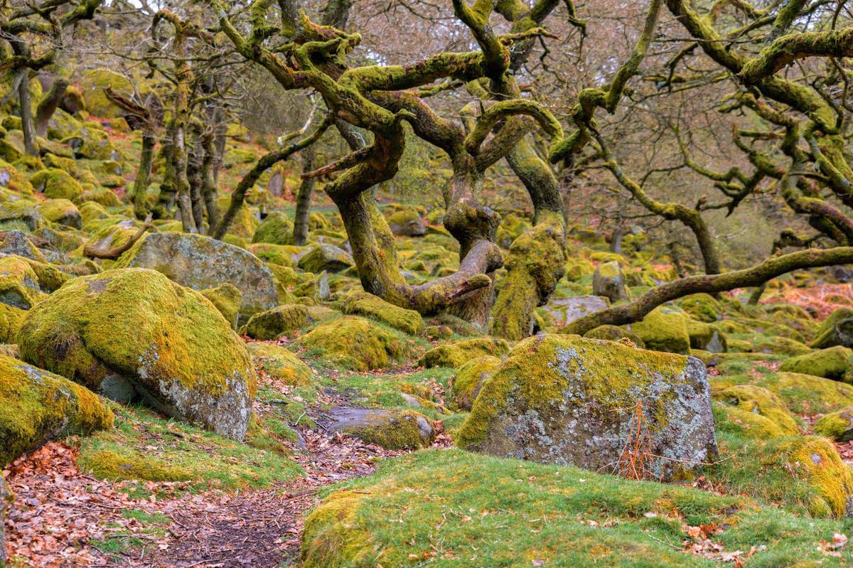
This stunning woodland is located in Dartmoor(Image: Getty)
One of Britain’s last remaining ancient temperate rainforests has been recognised amongst Europe’s most enchanting forest trails this summer. Wistman’s Wood, nestled within Dartmoor, secured third place on the list thanks to its remote location, centuries-old dwarf oak trees and captivating woodland scenery.
Travel specialists at Avis examined lesser-known European forests with Perućica Rainforest, in Bosnia and Herzegovina, claiming the top position and Spain’s Otzarreta Forest taking second place.
Though Wistman’s Wood was the sole British entry, it’s easy to see why this breathtaking location earned its spot.
Located just 31 miles from Exeter Airport, Wistman’s Wood offers convenient access for those exploring Devon.
The forest’s remarkable 500-year-old dwarf oaks have been twisted into gnarled, moss-draped shapes through centuries of Atlantic weather, emerging from a carpet of lichen-clad granite rocks.
The area feels more like a concealed treasure than a typical woodland, offering rewards to those who value ambience, legend and untamed scenery over picture-perfect vantage points.
Writing on Tripadvisor, one recent guest to the woodland commented: “Stunning ancient woodland that will make you feel like you are in a fairytale. A must-visit place. A lovely and easy walk from a small car park opposite the Two Bridges Hotel.
“The woodland is hidden in the fields, you cannot see it from the main road. It roughly takes one hour to reach it from the car park. We visited in autumn on a rainy day, and still, it was magical. This is one of the most unique woodlands you can find in the UK.”
A further visitor enthused: “The wood was fun, the lichen hung like Hagrid’s beard. The sights were astonishing and we saw loads of cows and sheep. I would recommend it to everybody.”