This incredible feat of engineering took 17 years of continuous construction to finish.
This tunnel is an incredible feat of engineering(Image: Getty)
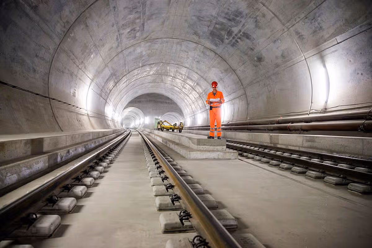
Ten years ago this month, construction finished on one of the most impressive feats of engineering in the world. The Gotthard Base Tunnel – a railway tunnel below the Lepontine Alps in Switzerland – is the longest and deepest transport tunnel in the world.
It opened in June 2016 and has provided a high-speed rail link between northern and southern Europe. Specifically, the train runs between Rotterdam in the Netherlands and Genoa in Italy.
It’s called a Base Tunnel as it travels through the base of the mountain, rather than trying to snake over the ranges.
This means that the journey on this train is by and large straight and flat.
The high speed trains that travel through it can reach speeds of 250km/h, slicing the journey time significantly.
Construction of this incredible tunnel took a whopping 17 years of continuous labour, and approximately CHF 12.2 billion (£11.2billion) to build.
Engineers and construction crews excavated more than 28 million tonnes of rock using massive boring machines to dig it out, as well as precious blasting to clear the way for the tunnel.
Before its construction, trains had to carefully traverse the winding mountain routes which meant travel speed and cargo capacity was significantly hampered.
Now, trains can whip through the solid rock mountain and travel between Erstfeld in the north to Bodio in the south in just 20 minutes.
This incredible tunnel runs for 57km and at its deepest point it is thousands of feet deep.
At the deepest point, trains are travelling at 7,546 feet below the surface.
Since its construction, the train has carried thousands of people with data showing that the number of people travelling through the Gotthard by train has almost doubled in 10 years
In 2025 the average was 16,400 a day, compared with 9,000 in 2015, according to the Swiss Federal Railways.
Williams was a key player for Forest last term, playing in 53 games as they maintained their Premier League status and reached the Europa League semi-finals.
He was named Forest’s player of the season and the City Ground club have opened talks with the Wrexham-born player over a contract extension.
“It’s physically and mentally tough, but we’re professional enough to deal with what gets put in front of us,” Williams added.
“If that’s games every other few days or the travelling, we’re prepared for that and I’ve enjoyed it.
“I’ll be going straight on holiday, having a few cocktails and putting my feet up on the beach.
“We’ll get a couple of weeks off and then straight back into it.”
EUROPE’S biggest mini-golf course spans 107,000 square feet – and it’s based in the UK.
With summer just around the corner, finding the best locations for a day out is key.
Sign up for the Travel newsletter
Thank you!
The UK is home to Europe’s biggest crazy-golf courseCredit: Adlington Golf CentreAdlington Golf Centre is home to Australian Adventure GolfCredit: Adlington Golf Centre
And it turns out that Europe‘s largest mini-golf course is located in an English town and boasts an epic Australian theme.
Adlington Golf Centre in Macclesfield is home to the huge Australian Golf Adventure experience, complete with an 18-hole course, a giant waterfall and snake statues.
Located around a 45-minute drive from Manchester, it’s the perfect family day out, described as “a fun, themed competition which involves putting a golf ball around challenging themed holes”.
Players can grab their club and tee off to enjoy each hole’s individual Australian-based decor.
The course is less than an hour from ManchesterCredit: Adlington Golf CentreThe 18-hole course has cool Australian detailsCredit: Adlington Golf Centre
From the Sydney Opera House to countless kangaroos, the course’s design means you don’t have to catch a long flight to get a taste of life Down Under.
The game is played on 1500 square metres of greens based on the impressive 10,000 square metre Cheshire site, while caves, bridges and a 7.5m waterwall add to the thrills.
While players can book before they arrive, spontaneous arrivals are welcome too, with individual tickets priced from £5.
Adult entry to the course will set you back £15 per person and a children’s tickets for 13 years and under is a tenner.
Individual tickets for the course start at just £5Credit: ADLINGTON GOLF CENTREThe site has caves, bridges and a waterfallCredit: ADLINGTON GOLF CENTRE
A family of two adults and two kids can go for £44, while spectators and kids aged four and under will cost just £5 each.
It’s even cheaper to book as a group of twelve or more, with adults down to £12, children to £8 and toddlers and spectators for £4.
The on-site café and coffee shops are open all day for refreshments after a long round of golf – serving snacks, hot drinks, hot food and pastries.
For those hoping to get stuck into something more grown-up, the centre also hosts two nine-hole golf courses, a foot golf course and a driving range for a good whack.
There’s good news if you’re riding the padel hype, too. Adlington Golf Centre will soon be home to four brand new, state-of-the-art padel courts, set to open this year.
How often do you look down and wonder who created the path your feet are following? Or ask the cause of its curves and dips? Formed over thousands of years, paths form an “internet of feet” – a web of bridleways and hollow ways, drove roads and ridgeways, coffin tracks, pilgrimage trails and city pavements. Whether you’re hiking a National Trail or pottering along a National Trust footpath, there’s a good chance you’re following ancestral steps.
It’s thoughts like these that led me on a journey to track the evolution of British paths for my book, The Path More Travelled. Eleven thousand years ago ice age hunter-gatherers arrived from Europe’s heartlands, moving through the wilderness along broad “routeways”, that later widened to tracks when horses and then wheels were adopted in the bronze age. For more than 2,000 years, traffic moved no faster than the speed of a horse, until the internal combustion engine drove pedestrians off the road just over a century ago.
In search of the capillaries that gave life to every community in Britain, I revisited coast paths, tramped shepherds’ trails and followed the serpentine curls of rivers. Here are a few of my favourite paths that bring history to life.
Sweet Track, Somerset Levels
A replica of the neolithic Sweet Track though wetland at Shapwick Heath national nature reserve. Photograph: Craig Joiner Photography/Alamy
The hunt for prehistoric paths took me deep into the wetlands of the Somerset Levels, where the Sweet Track was discovered in 1970. Built nearly 6,000 years ago (3806BC) by early farmers who needed access to an island, the collapsed boardwalk was preserved in peat. But a short walk from the Avalon Marshes centre (with an excellent cafe and open-air museum), woodland paths explore Shapwick Heath nature reserve, where a replica section of the Sweet Track teeters through the reeds. Visitors can walk in single file along this narrow, timber causeway and imagine the world of the Neolithic pioneers who colonised Somerset’s reflective waterways long before they were drained and converted to farmland. For modern versions of the Sweet Track, visit the Norfolk Broads and Norfolk coast path, where stilted, planked boardwalks wend their way through reedbeds, salt marshes and swamp woodland known locally as alder carr.
Street of the Dead, Iona
The coffin road leading to Iona Abbey. Photograph: Charles Hutchison/Alamy
Writing this book led me to the far west of Scotland and the tiny island of Iona, where, after decades of tramping Britain’s paths, I walked for the first time along Sràid nam Marbh, the Street of the Dead. Across Britain, coffin roads, or corpse ways, were used by remote communities to convey their dead to cemeteries. Iona’s is no more than a few hundred metres in length, and most of it takes the form of a narrow, kinking lane leading from the ancient landing beach of Port nam Mairtear (Martyr’s Bay) to the site of a monastery founded in 563. Along this ancient road came the bodies of great Gaelic lords, bound for burial close to the monastery. For many, it’s a “thin place”, where the space between this world and the next narrows. You pass the ruins of an Augustinian nunnery established in around 1200, and the MacLean’s Cross, whose intricately carved floral and animal motifs and outstretched Christ captivated pilgrims. Then the abbey appears and the Street of the Dead, angling across the grass, the final section a short avenue of red granite slabs, sunken by the weight of time into the turf of the abbey precinct. There are very few roads in Britain where you can place your feet on to slabs that have been trodden by so many generations.
Bure Valley Path, Norfolk
The Bure Valley Path runs next to a vintage steam train line. Photograph: David Chapman/Alamy
One of my favourite walks traces the banks of the River Bure between the market town of Aylsham and the railway village of Hoveton. It’s a typical, gentle Norfolk valley of slow meanders, cascading willows, kingfishers and herons. It was like this 100 years ago, when huge timber sailing barges, wherries, used to glide silently upriver to Aylsham’s mills. Close to the river ran a steam railway line linking Hoveton and Aylsham. Today, the nine-mile Bure Valley Path is a shared walking and cycling route that follows the course of the old railway, now relaid as a narrow-gauge steam line, the Bure Valley Railway. Cycling the path is fun, but a superb walk awaits those who take the steam train from Hoveton to Aylsham then walk back towards Hoveton on the Bure Valley Path for about two miles, where a footpath on the left drops down to the waterside church of St Mary’s in Burgh-next-Aylsham. From here, riverside footpaths head downstream past white-painted watermills and old navigation locks while occasional steam locomotives contribute to the sylvan backdrop. At Coltishall, you can rehydrate at The Rising Sun, stroll along Anchor Street where wherries were built, and then return to the Bure Valley Path for the final two miles back to Hoveton. I know of no other walk so closely related to the eras of wind and steam.
The Ridgeway, Hertfordshire to Wiltshire
The Uffington White Horse. Photograph: John Henshall/Alamy
The Ridgeway runs for 87 miles from Ivinghoe Beacon high in the Chiltern Hills to the prehistoric stone circle at Avebury in deepest Wiltshire. On its rolling heights, you can walk back to the iron age, when formidable hill forts commanded the vales. The ghosts of warrior-farmers can be sensed most powerfully on the western end of the Ridgeway, where the chalky trail climbs past the ramparts of Uffington, whose banks and ditches – once braced with timber and chalk rubble – enclose an area twice the size of a football pitch. Right beside the fort, a 110-metre long white horse gallops across the down, cut deep into the turf during the late bronze age or early iron age. One mile to the west, the Ridgeway passes the chambered long barrow known as Wayland’s Smithy, which once contained the remains of 14 people dated to between 3590 and 3550BC. The Ridgeway’s knack of time travel has long appealed to writers and photographers, from Thomas Hardy and Richard Jefferies, to Richard Mabey and Fay Godwin, whose book The Oldest Road: The Ridgeway(1975), unravelled the path connecting deep history with a modern national trail.
Holloways, Surrey Hills
A holloway path at Holmbury St Mary in the Surrey Hills, near Leith Hill. Photograph: Matt Mawson/Getty Images
A holloway is a sunken path, an old way worn into the land by centuries of feet and hooves. Holloway walls can be almost vertical, cut back to raw rock and roots. Some are like ravines. Others are virtual tunnels, roofed with living trees. Some appear unexpectedly as gentle troughs in the landscape. They occur most dramatically in softer geologies like chalk, sandstone and greensand. Most are just a few minutes’ walk in length, but there are parts of the country where exploration will produce some very enjoyable clusters. There are three modest holloways right beside the White Horse of Uffington on the Ridgeway, cut perhaps in prehistoric times by cattle being moved from their winter quarters in the vale to the summer grasses of the high downs. In Holloway (2012), Robert Macfarlane wrote so poetically of a buried path in the Chideock valley of south Dorset that it’s become a cause of pilgrimage for those of us who look for these places. The Surrey Hills are laced with secretive holloways. Among my favourites are the sunken tracks on the greensand of Leith Hill and farther west, the old holloways of Hascombe Hill and Hydon’s Ball. It’s along these semi-subterranean trackways that you’re most likely to detect the steady plod of Saxon cattle. Or Hobbits.
The Mass Trespass Walk, Derbyshire
The path up William Clough on the Kinder Scout Mass Trespass walk. Photograph: Acorn 1/Alamy
The story of countryside access is written in the grit of Kinder Scout, whose frowning sandstone forms the highest point in the Peak District. In April, 1932, an excited gaggle of hikers climbed the footpath from the Derbyshire village of Hayfield up towards the brow of Kinder Scout, where they clashed with squads of gamekeepers intent on preventing public access to the moorland. Legislation followed and today the path up William Cloughis described on the National Trust website as the Kinder Scout Mass Trespass Walk. A vigorous eight-mile loop along the crags and back down to Hayfield, it offers the full Pennine repertoire in a single outing, from glittering reservoir to whispering moorland and monumental rocks. It includes Kinder Downfall cascade and a section of the Pennine Way, the earliest of Britain’s national trails. I walked the trail one blustery December day, ambushed by snow flurries and sunshine that spotlit Manchester like spilt crystals on the dark plain. I’ve climbed Kinder from many directions, but this is the route that tells the best story.
Nicholas Crane’s new book, The Path More Travelled, The Secret History of Britain’s Footpaths, is published by Weidenfeld & Nicolson (£25). To support the Guardian, order your copy at guardianbookshop.com. Delivery charges may apply.