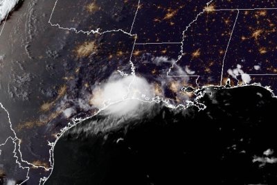
Tropical Storm Edouard moves inland, flash flooding possible

Tropical Edouard made landfall Tuesday at the Texas-Louisiana border. The storm is expected to weaken into Wednesday. Photo courtesy of the NOAA.
Sept. 1 (UPI) — Tropical Storm Edouard made landfall Tuesday at the Texas-Louisiana border, moving inland toward the northwest with gusty winds and heavy rainfall.
The National Hurricane Center said a tropical storm warning was in effect from Port Bolivar, Texas, to the Vermilion/Cameron parish line in Louisiana. As of Tuesday afternoon, wind speeds had slowed to about 50 mph after measurements of about 60 mph at landfall.
“Continued weakening is expected during the next day or so, and Edouard is forecast to weaken to a tropical depression tonight and dissipate by Wednesday night,” the NHC said.
The storm’s small size will lessen its impact, CNN reported. “Locally significant flash flooding” is possible in southeast Texas, and river flooding was also possible. Texas Gov. Greg Abbott activated the state’s Emergency Operations Center to prepare, mobilizing more than 1,500 personnel.
The storm is expected to produce 3 to 7 inches of rainfall with some totals up to 12 inches for parts of the upper Texas coast inland through east-central Texas, the NHC said. There is the potential for 2 to 4 inches in far southwest Louisiana.
Tornadoes are possible through Tuesday evening across parts of southwest Louisiana and southeast Texas.
A storm surge/tide combination could cause normally dry areas near the coast to flood, the NHC said. The degree of this flooding depends on the timing of the surge and tidal cycle.