Weekly insights and analysis on the latest developments in military technology, strategy, and foreign policy.
Days after a Ukrainian strike on a Russian dam designed to impede Russian logistics, videos and photographs are emerging showing flooded dugouts and vehicles stuck in the mud in the northern Kharkiv region. Ukrainian military officials and a local Russian media outlet claim the attack on the Belgorod Reservoir Dam on the Siverskyi Donets River is working as intended, helping to slow down Russian advances near the embattled town of Vovchansk.
You can see a satellite view of the results of the attack in the following video.
🌊 Belgorod Flooding — Aftermath from Space
Satellite imagery shows massive flooding below the Belgorod reservoir after the dam strike — water is spreading fast, cutting off roads, supply routes, and defensive lines along the border region.#Belgorod#Russia#WarInUkraine… pic.twitter.com/ZFqvhGBpHR
— 🇺🇦 Ukraine Frontline_Daily (@ukraine_frontup) October 27, 2025
“Enemy logistics are becoming significantly more complicated,” the Ukrainian 16th Army Corps stated on Telegram in reference to the results of water streaming out of the dam. “The leaves have also fallen. So the units that managed to cross the Siverskyi Donets found themselves practically cut off from the main forces.”
“We are waiting for reinforcements for the exchange fund,” the corps added, using a reference to prisoners of war.
A Russian outlet offered a similar take.
“Light military equipment sunk in mud on one of the roads in the Vovchansk direction,” the local Belgorod Pepel Telegram channel posited. “Water from the Belgorod reservoir has reached the positions of the Russian army and washed out the roads, greatly complicating logistics and the combat capability of the Russian Armed Forces in the Vovchansk direction.”
“Our dugout was flooded after the dam was blown up,” a Russian soldier is heard to complain on one of the videos.
Water from the Belgorod Reservoir reached Russian army positions and washed away roads, significantly complicating logistics and combat capabilities for Russian forces in the Volchansk direction. pic.twitter.com/dCQp6juea7
Ukraine’s Commander of Unmanned Systems Forces, Col. Robert Brovdi, said the dam was hit by drones on Saturday.
Meanwhile, the regional governor said it was attacked on Friday as well.
“As a result of the strike by the Armed Forces of Ukraine, there is damage to the dam of the Belgorod reservoir,” Vyacheslav Gladkov stated on Telegram on Saturday. “We understand that the enemy may try to strike again and destroy the dam. If this happens, there will be a threat of flooding of the river floodplain from the Kharkiv region side and several streets of our settlements, where about 1,000 residents live.”
Though the dam is located a little more than eight miles north of the border, the flood waters that resulted from the attack have swollen the Siverskyi Donets River, which bisects Vovchansk, located about four miles south of the border.
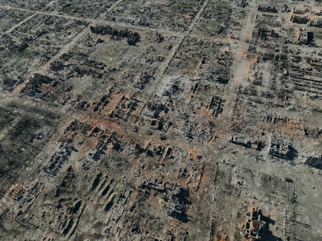
The bombed-out town has become a focal point of the fighting in northern Ukraine. It was liberated in September 2022 but a Russian counteroffensive managed to recapture a portion of the town in May 2024.
An aerial view shows the destroyed city of Vovchansk in the Kharkiv Region near the border with Russia, on October 2, 2024. (Photo by Libkos/Getty Images) Libkos
Both the Ukrainian and Russian defense ministries say the fighting remains fierce in the area, with Moscow claiming to have inflicted severe damage during these battles.
Before the dam attack, the Russians had made gains in the area thanks to the summer’s heat, according to the Ukrainian 16th Army Corps.
“The enemy tried to fully take advantage of the window of opportunity – after the lack of precipitation and the hellish summer, the rivers Siverskyi Donets and Vovcha have dried up, which simplified logistics for the opponent,” the corps stated on Telegram. “Plus, they managed to accumulate reserves and there are still enough leaves on the trees – all this combined led to a sharp increase in activity in the Vovchansk direction.”
The Russians “managed to achieve local successes, but it came at the cost of heavy losses,” the corps claimed. “Some units almost completely lost combat readiness, for example, the 1st battalion of the 82nd Marine Regiment was almost wiped out, with only the command left in the unit, so it had to be withdrawn to the rear for replenishment.”
“As of today, the situation is no longer in favor of the Russians,” the 16th Corps suggested.
A satellite view of how the Belgorod Reservoir dam looked before the attack. (Google Earth)
Still, Ukrainian forces are not yet able to take full advantage of any logistical impediments imposed on Russian forces by the dam bust, stated one noted Ukrainian journalist.
“Comrades located at various sections of the Vovchansk direction responded, saying that assault actions and drone operations have not decreased over these 2 days,” Sergey Bratchuk wrote on Telegram. “This is despite the weather conditions, which noticeably complicate the work of UAV crews.”
“Due to (so far) constant tension, they do not allow the so-called ‘window of opportunity’ to be used for improving their own logistics, personnel shifts at positions, and strengthening defensive lines,” he added.
The lack of Ukrainian progress may change as water continues to flow from the dam, Bratchuk suggested.
“Well, let’s see how they behave in a few days when all the main access routes are flooded, the crossings are flooded, and the fortifications are destroyed,” he explained. “Without provisions, ammo, fuel, generators, etc. – offensive capabilities will somewhat quiet down. Infantry are not demanding people; you can even drop them a package and they will hold out for a long time, but supplying pilot positions is a completely different matter.”
The Belgorod attack is the most recent, but certainly not the largest strike on a dam. In March 2023, Ukraine claimed that the Russians intentionally blew up the Nova Kakovka dam on the Dnipro River, intending to impede Ukrainian logistics. While the extent of that objective is unclear, the attack caused major flooding and created a massive ecological disaster in the region.
Just how much the attack on the Belgorod Reservoir dam will hurt Russia remains to be seen. However, the strike is the latest example of how both sides are using water to try and stop the other.
Ethiopia has inaugurated the Grand Ethiopian Renaissance Dam, Africa’s largest hydro power project. Al Jazeera’s Bernard Smith says the dam is a source of national pride but remains contentious among downstream nations including Egypt and Sudan.
Ethiopia celebrates Africa’s largest hydroelectric dam as Egypt and Sudan express fears over water security.
Published On 9 Sep 20259 Sep 2025
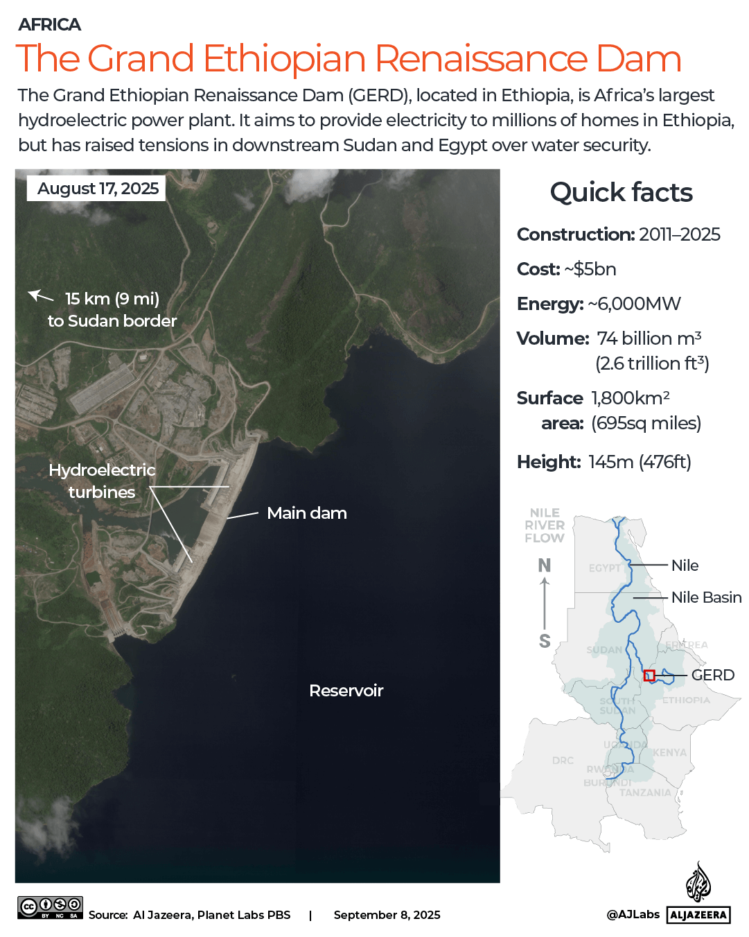
Ethiopia has inaugurated Africa’s largest hydroelectric dam on the Blue Nile, as the $5bn project continues to sow dismay with downstream neighbours Sudan and Egypt.
Prime Minister Abiy Ahmed has hailed the Grand Ethiopian Renaissance Dam (GERD) as a “shared opportunity” for the region that is expected to generate more than 5,000 megaWatts of power and allow surplus electricity to be exported.
Recommended Stories
list of 3 itemsend of list
A handful of regional leaders, including Kenya’s President William Ruto and Somalia’s President Hassan Sheikh Mohamud, attended the festivities in person on Tuesday, which kicked off the night before with lantern displays and drones writing slogans such as “geopolitical rise” and “a leap into the future”.
But Sudan and Egypt – who rely heavily on the Nile for water supplies – have expressed fears that the dam will threaten their water security and even breach international law. Their leaders did not attend the inauguration of the dam.
The Blue Nile, one of the Nile’s two main tributaries, flows north into Sudan and then Egypt. The dam is located just 14km (9 miles) east of the Sudanese border, measuring 1.8km (1.1 miles) wide and 145 metres (0.1 mile) tall.
“I understand their worries, because of course, if you look at Egypt from the sky, you see that the street of life is existent” thanks to the Nile, Pietro Salini, the CEO of Italian company Webuild that constructed the dam, told Al Jazeera. But “regulating the water from this dam will create an additional benefit” to neighbours, he added.
(Al Jazeera)
‘Continuous threat to stability’
GERD has spawned regional tension since it was launched in 2011, with years of cooperation talks between Ethiopia, Sudan and Egypt still stalled.
Last week, Sudan and Egypt released a joint statement calling Ethiopia’s actions “unilateral” and saying the dam posed a “continuous threat to stability”.
Sudan’s Roseires Dam, located about 110km (70 miles) downstream of GERD, faces potential future effects if Ethiopia were to perform large water releases without coordination, reports Al Jazeera’s Mohamed Vall.
“Roseires is the closest, it’s 60 years older, and when constructed was 25 times smaller – and will likely bear the brunt of the fallout if anything goes wrong at the Ethiopian dam,” Vall said.
But GERD may also provide benefits such as regulating the annual flow of the river and reducing potential flooding in villages on the banks of the Nile.
Abdullah Abderrahman, Roseires Dam administration manager, told Al Jazeera that GERD has helped to control overflow at Roseires that “used to be extremely big”.
“Then there is the reduction of the huge amounts of silt and trees that the rainy season used to bring into Roseires, causing its storage capacity to shrink by a third,” Abderrahman added.
Dessalegn Chanie Dagnew, associate professor of water resources at Bahir Dar University in Ethiopia and a member of the Ethiopian parliament, told Al Jazeera the dam’s benefits could eventually reach beyond assuaging flooding and silt.
Rather than creating tension, he said, GERD “will also serve as a project that can really bring about regional integration and cooperation”.
Sikkim, India – It was the middle of the night when Tashi Choden Lepcha was jolted awake by the tremors that shook her mountainside home in Naga village. Perched above the Teesta River, which flows through a gorge just below, Naga is a remote village in India’s northeastern Himalayan state of Sikkim. For centuries, it has been home to the Indigenous Lepcha people.
“It felt like an earthquake,” the 51-year-old mother of five says of the events of October 4, 2023. “The whole house was shaking. It was raining heavily, there was no electricity, and we couldn’t see anything.”
In the pitch dark and amid the heavy downpour that night, Lepcha roused her three children, aged 13, 10 and five, and rushed out of the house with her husband, panicking. Together with a few neighbours, they searched for a safe space on higher ground. That’s when they noticed a distinct smell of mud and something like gunpowder.
Moments later, an enormous, tsunami-like wave surged down with terrifying force. Lepcha didn’t know it at the time, but it was a glacial lake outburst flood (GLOF), which had been triggered by the sudden avalanche of ice and rock into the South Lhonak Lake – a glacial lake high up in the Teesta basin in North Sikkim.
The impact breached the lake’s moraine wall, releasing more than 50 million cubic metres of water. The flood destroyed the 1,200-megawatt Teesta III dam – Sikkim’s largest hydropower plant, located at Chungthang on the River Teesta, the largest river in Sikkim, which originates in the eastern Himalayas. The dam’s collapse released an additional five million cubic metres (equivalent to 2,000 Olympic swimming pools) of reservoir water.
The high-velocity flood in the Teesta River valley carried about 270 million cubic metres of sediment and debris along with it, causing widespread devastation across Sikkim, parts of West Bengal and Bangladesh through which the Teesta flows.
At least 55 people were killed, 74 went missing, and more than 7,025 were displaced. The flood damaged nearly 26,000 buildings, destroyed 31 bridges and flooded more than 270 square kilometres of farmland. It also triggered 45 landslides, damaged four dams and destroyed long stretches of National Highway 10.
Both Teesta III and Teesta V, another hydroelectric dam near Dikchu in Balutar, have remained shut since they were severely damaged during the flood. Repair work is continuing, but neither of the dams has generated electricity for almost two years.
Scientists say the scale of the destruction makes it one of the most devastating flooding disasters recorded in the Himalayas in recent decades.
Tashi Choden Lepcha, whose family lost both their houses in Naga village to the 2023 glacial flood. Nearly two years later, she still has no home [Arunima Kar/Al Jazeera]
Rebuilding amid ruin
Today, Naga village, located about 73 kilometres from Sikkim’s capital, Gangtok, is deserted due to continuous land subsidence. Houses are cracked, have collapsed or are still standing but leaning towards the river flowing below. The main NH10 road passing through the village has been destroyed with long, deep cracks.
In all, about 150 families lost their homes and land in the flood and now face an uncertain future. Lepcha’s family lost both their houses, which collapsed in the landslides. They, along with 19 other families, are now living temporarily in a government tourist lodge in Singhik, about 10km from their home.
As the region struggles to recover, and communities along the Teesta remain displaced and vulnerable, the Ministry of Environment, Forest and Climate Change (MoEF&CC) has approved plans to rebuild the Teesta III dam without any public consultation, despite concerns about the risk of future glacial lake outburst floods and the fact that the Himalayan range running across Sikkim is seismically sensitive.
With the ongoing monsoon season, the Teesta’s water levels have risen significantly. This has already caused several landslides in North Sikkim, washing away the under-construction Sankalang bridge and cutting off large parts of the region.
Long stretches of roads across North Sikkim are still unpaved, muddy and full of rubble. Several bridges damaged during the 2023 flood and the monsoon next year are yet to be rebuilt.
The quality control lab at the Chungthang dam site has also been swept away, halting construction work. “It looks like a war-torn area. How will they rebuild Teesta III?” asks Gyatso Lepcha, a climate activist with Affected Citizens of Teesta (ACT), a group of Lepchas campaigning against large hydropower projects and environmental conservation in the region.
“A detailed risk assessment considering future climate scenarios, glacial behaviour, hydrological changes, and sedimentation rates is essential before deciding to rebuild the dam in the same location,” says Farooq Azam, senior cryosphere specialist at the International Centre for Integrated Mountain Development (ICIMOD).
In the absence of such an assessment, the region’s Lepcha communities, who fear further disaster, are protesting against the construction.
Naga village in north Sikkim, with its cracked and sinking houses and roads, is deserted following the glacial lake flood in 2023 [Arunima Kar/Al Jazeera]
A controversial dam
Sikkim is home to 40 of India’s 189 potentially dangerous glacial lakes across the Himalayan region, many of which are at risk due to rising temperatures and glacial melt driven by climate change.
Built on a river already lined with dams constructed by the National Hydroelectric Power Corporation (NHPC), the Teesta III dam was originally pitched as a renewable energy project.
Approved in 2005 with a budget of Rs 5,705 crore (about $667m), the dam actually cost more than Rs 14,000 crore ($1.6bn) to build by the time it became operational in 2017. Delays were caused by the 2011 earthquake, which destroyed major infrastructure, and also repeated flash floods and landslides.
The dam faced criticism from environmentalists and the All India Power Engineers Federation (AIPEF), which described it as a “failed example of public-private partnership” for the massive cost overruns, years of delay, ecological damage and disregard for Indigenous rights and livelihoods.
The operator, Sikkim Urja Limited (formerly Teesta Urja Ltd or TUL), was forced to sell electricity at half the agreed rate as buyers, including the states of Punjab, Haryana, Uttar Pradesh and Rajasthan, refused to pay higher prices. In 2017, transmission delays caused yet more losses of about Rs 6 crore ($701,000) per day from June to September 2017.
Following the devastating flooding of 2023, the estimated reconstruction cost for the dam is now Rs 4,189 crore ($490m), but experts question how such a large-scale reconstruction could be completed at less than a third of its original building cost.
An investigation in May this year renewed concerns about the project. The Sikkim Vigilance Police, a special police force, found irregularities in the process used to select the independent power producer, who, according to the findings of the police investigation, lacked the qualifications for a project of this scale. It was alleged that critical dam design parameters had been compromised as a result.
Other reports have found that environmental assessments also overlooked key risks. A 2006 biodiversity report [PDF] from Delhi University had identified the Chungthang region as a highly sensitive ecological zone. Yet the project received swift environmental clearance from the environment ministry based on a report which claimed that little to no significant wildlife existed in the area. The clearance procedure also bypassed the ministry’s own directive that no dams could be approved in Sikkim until a full “carrying capacity study” (a study of an area’s capacity for supporting human life and industry) of the Teesta basin had been completed.
“What was the hurry to give clearance for rebuilding even before the Central Water Commission and Central Electricity Authority cleared the design?” asks Himanshu Thakkar, coordinator of South Asia Network on Dams, Rivers and People (SANDRP), an advocacy group working on the water sector. “The Environmental Impact Report (EIA) used was done before 2006, which didn’t consider the risk of a GLOF. It contributed to the disaster, and now the same flawed EIA is being used again. Even the dam safety report prepared after the collapse hasn’t been made public or considered for this decision.”
Teesta Bazar in Kalimpong, West Bengal, endured extensive destruction in the October 2023 glacial lake outburst flood [Arunima Kar/Al Jazeera]
While a “concrete faced rockfill dam” is planned this time – supposedly more resilient to flooding than the old “concrete gravity dam” design – experts and local communities still worry this won’t be enough because, they say, key impact studies are incomplete.
Al Jazeera reached out to MoEF&CC with questions about why the Teesta III reconstruction had been approved without a new EIA, despite concerns over safety and ecological impacts. Questions were also sent to Sikkim Urja Ltd regarding reconstruction plans and structural safety and to NHPC about the cumulative impacts of multiple dams along the Teesta. Emails and calls to all these offices remained unanswered by the time of publication.
Tunnelling and blasting during the original construction of Teesta III, before it opened in 2017, led to landslides, erosion and damage to homes. Yet, no comprehensive assessment has been conducted on seismic risks, reduced river flow or long-term ecological impacts.
“Our soil is fragile,” says Sangdup Lepcha, president of ACT. “We are seeing more landslides every year. During the GLOF, the soil was completely washed away. If tunnels are dug again under our villages, the area could collapse.”
Sangdup, who lives in Sanggong village in Lower Dzongu, says the 10km stretch from Namprikdang to Dikchu is the only remaining stretch of the Teesta without any dams.
Many worry that if the rebuilding of Teesta III continues without safeguards, it will put villages at risk. “We have already seen what happened in Naga,” says Sangdup. “Why is the project getting emergency clearance while affected families are still waiting for rehabilitation?”
Teesta Bazar in Kalimpong, West Bengal, was one of the worst-hit areas downstream of the Sikkim dam during the October 2023 glacial lake outburst flood. Roads are still unstable and cracked, and many houses are sinking into the Teesta River [Arunima Kar/Al Jazeera]
Sacred land
Dzongu, a region bordering the Kanchenjunga Biosphere Reserve in North Sikkim, is a protected reserve for the Indigenous Lepcha community. Known for their spiritual ties to the rivers and mountains, the Lepchas from Dzongu have long resisted large-scale hydropower projects in the region to protect their identity, livelihoods and the biodiversity of the region.
When multiple dams were proposed in the early 2000s along the Teesta basin – a river the Lepchas revere as a living deity – ACT spearheaded protests against dam construction. Their hunger strikes and protests led to the cancellation of four major hydropower projects in Dzongu and four outside.
“We are animists,” says Mayalmit Lepcha, ACT’s general secretary. “Our traditions, culture, identity, and everything else are tied to Mount Kanchenjunga, Teesta, Rangeet and Rongyong rivers here.”
Despite their long history of activism, the communities say they were ignored during the public consultation process, even though their land and rivers would be used for the proposed 520 MW Teesta IV hydroelectric project.
At least 16 villages lie near the potential construction site, across the agricultural belt of North Sikkim. The project would include building tunnels underneath Hee Gyathang and Sanggong villages in Dzongu to carry water to the power station. The siltation tunnel, which will divert sediment-laden water away from the main reservoir, is supposed to run beneath the Tung Kyong Dho, a sacred lake known for its rich biodiversity.
Songmit Lepcha, from Dzongu’s Hee Gyathang village, told Al Jazeera that she lost her livestock and plantation during flash floods in June last year. “We are scared of rebuilding our homes,” Songmit said, her voice filled with worry.
Opposition Citizen Action Party (CAP) leader Ganesh Rai told Al Jazeera that he is particularly worried about the new plans to rebuild the dam to a height of 118.64 metres, twice as high as the original. “With climate change intensifying, any future breach could submerge all of Chungthang,” he said. “It won’t just affect Dzongu but everyone downstream.”
That could include settlements in Dikchu, Rangpo, Singtam and Kalimpong, and Darjeeling and Jalpaiguri districts in West Bengal, which were severely affected by the 2023 flood. In places like Bhalukhola near Melli, families have been living in makeshift relief camps since the 2023 floods. Conditions are difficult, with limited access to clean water, sanitation and medical care.
Leboon Thapa’s house in Bhalukhola, Kalimpong, was destroyed by the 2023 glacial lake outburst flood in Sikkim. He has been living with his parents in a single, cramped room in the relief camp alongside the Teesta highway since then [Arunima Kar/Al Jazeera]
Struggles downstream
The 2023 flood did not just destroy 22-year-old Leboon Thapa’s family home in Bhalukhola in north Bengal, about 100km downstream from the site of the old Teesta III dam. It also disrupted his dreams of a professional football career.
Leboon is now living with his parents in a single, cramped room inside a relief camp along the Teesta highway, which is situated above Bhalukhola. They are sandwiched between works being done to widen the highway in front of their site, and the ongoing tunnel construction work for the Sevoke-Rangpo railway project behind them. The exposed location leaves them at risk of landslides and flooding.
“If they are rebuilding the dam, they must build protection walls here for our safety,” says the lanky, athletic young man, looking around at what’s left of his village. The fields he played football in as a child, as well as the playground he once ran about in, are now buried under silt and debris. “We only have this land. If we lose it, where do we go?”
About 10km further downstream in Teesta Bazar, 68-year-old Tikaram Karki lost his house and motorcycle repair shop to the 2023 flooding. His home, built above the riverbank, began cracking and sliding just a few days after the flood.
“We were hiding in the mountains in the rain. When we came back at 6am, there were no houses, roads, or electricity,” he says, as he stands next to what remains of his house and shop, both of which are leaning steeply towards the Teesta. He smiles even as he talks about his losses since that dreadful night.
Tikaram now lives in a rented house with his family of four. He is paying Rs 8,000 ($93) monthly rent while struggling with financial losses as he has no way to run his business.
He received some compensation from the West Bengal state government, but it does not cover all he has lost. “I have been living here for 30 years and spent Rs 30 lakh ($35,000) building my house. I only got Rs 75,000 ($876) in compensation. What will happen with that?”
Like others here, Tikaram says he believes the destruction was made worse by years of poor planning and unchecked silt buildup caused by the dam, which raised the riverbed of the Teesta.
“If they had cleared the silt during the dry months, we wouldn’t be so vulnerable now,” he says.
“I cannot tell the government not to build the dam, but they should build proper protection for all the people still living along Teesta,” adds Tikaram.
Tikaram Karki’s home and motorcycle repair shop in Teesta Bazar, Kalimpong, are sinking into the Teesta River following the October 2023 flood, which caused massive destruction to property in the region [Arunima Kar/Al Jazeera]
Rising risk
In a January 2025 study by an international team of scientists and NGOs published in the Science journal, researchers warned that South Lhonak Lake is one of the more rapidly expanding and hazardous glacial lakes in Sikkim. The lake expanded from 0.15 square kilometres in 1975 to 1.68sq km by 2023, posing a danger of flooding to the communities downstream.
“The Teesta-III dam played a significant role in amplifying the downstream impact of the South Lhonak GLOF disaster,” Azam, at the International Centre for Integrated Mountain Development (ICIMOD), tells Al Jazeera.
Azam explains that while the disastrous flood could not have been prevented, its impact could have been significantly reduced through better infrastructure planning and active monitoring of the lake. “Reinforced spillways, sediment handling systems, and early warning systems linked to upstream sensors could have provided critical response time,” he says.
The night the flood hit, the dam’s power station was still operating. According to Thakkar, authorities had received alerts well in advance, but there were no standard operating procedures or emergency protocols in place about opening spillway gates during such situations. “And there has been no accountability since,” he added.
Thakkar says he is deeply concerned that the dam is being rebuilt without taking into account the flood potential based on current rainfall patterns.
“And what happens to the other downstream dams when this one releases excess water during the next flood?” he asked. “None of them are being redesigned to withstand that kind of excess flow.”
Rai criticises the state’s priorities, saying the government was “pushing for more dams instead of strengthening disaster preparedness” at a time when the frequency of extreme weather events is expected to increase.
Once a thriving town, Chungthang in North Sikkim is now strewn with rocks, boulders and a deep layer of sand and debris after the 1,200-megawatt Teesta III dam was destroyed by a massive glacial lake outburst flood from South Lhonak Lake, above, in Lachen [Arunima Kar/Al Jazeera]
‘No Future Here’
Nearly two years after the October 2023 flood, Tashi Choden Lepcha still has no home. Her voice chokes up as she speaks about her houses in Naga village.
“We were born there, raised children there. Now we have nothing,” she says of herself and her husband, wiping her tears. Her brother used to live next door: he lost everything as well.
After the disaster, she, her husband and children stayed in a school building in Naga. But when cracks appeared in the school walls, they were shifted to Singhik. The lodge, too, is beginning to show cracks in the kitchen and bathroom.
Her husband and children have since relocated to Siliguri, about 150km away, for work and education, while she stayed behind alone because she teaches at Naga Secondary School.
The government gave them Rs 1.3 lakh ($1,520) in compensation, but most of it went on the cost of moving their belongings to different locations.
There have been discussions about allocating land higher up in the mountains for the displaced families. But many of them fear it could take years before they are rehoused. “If the government gives us land in a safe location, we can build a house. How long can we live like this? We have no future here,” she says now.
Most people in the surrounding villages share her fears. They want the dam project scrapped or moved to a safer location.
Mayalmit echoes this call for caution. “We’re going to have more GLOFs, there’s no doubt,” she says.
“People will have confidence only if decisions are based on proper impact assessments, considering all factors, and done in a transparent way,” Thakkar adds. “But that’s not happening now, which is why there’s scepticism about hydro projects among locals.”
He says that Indigenous communities must be part of the decision-making process. “They’re the ones most at risk, and also the most knowledgeable.”
Praful Rao of Save The Hills, an NGO working in disaster management in North Bengal and Sikkim, has called for joint disaster planning between the two states. “What happens upstream affects us downstream. It is time we work together for science-based disaster planning, not blindly push dam projects for revenue.”
While hydroelectricity is important for India’s energy future, Rao warns against unchecked expansion. “You can’t build dams every few kilometres. We need to study how many this fragile region can safely support.”
Mayalmit urges central and state authorities to reconsider the approval. “Don’t act against Indigenous rights, the environment. I speak for the rivers, the birds and the animals here.”
Residents of Maiduguri, capital of Borno State, North East Nigeria, who live near the Alau Dam and its downstream channel, are in a state of confusion, grappling with conflicting government directives on the dam’s water release. The mixed messages are sparking widespread concern over potential flood risks.
The conflicting messages from these two key government bodies have left residents uncertain about the immediate danger and the appropriate course of action. While the Chad Basin Development Authority (CBDA) suggests a controlled release of the dam that shouldn’t cause panic, the State Emergency Management Agency (SEMA) is demanding immediate evacuation, indicating a potentially serious flood threat.
“We really don’t know which warning or advisory to follow now,” said Yunus Isa, a resident whose house was submerged in the devastating September flood last year. “I hope we will not be left in the darkness about reality until it is too late.”
The September flood resulted from the breakdown of the Alau Dam after years of neglect and warnings that the flood would happen. It swept through several local government areas of Borno State and affected about one million residents, according to the emergency management agency. HumAngle investigations found money trails that were allocated to the repair of the dam over the years, yet the repairs never happened.
This Wednesday, the CBDA announced the opening of the Alau Dam’s spillway gates to release water downstream. In a special announcement, they tried to calm fears, stating, “The general public should note that the spillway gates of the Alau Dam have been opened for water in the reservoir to spill downstream steadily… people, especially those living within the River Ngadda and Gwange area, should not panic by seeing the water passing through its normal way.”
CBDA’s Executive Director for Engineering, Engr. Mohammed Shettima, who signed the statement, added that the authority would keep monitoring the dam’s activities until water levels recede.
However, SEMA has issued an urgent public notice concerning the dam’s water release with a stern directive: “Evacuate Immediately: All communities and individuals living or working near the Gadabul River and its tributaries must relocate to higher ground without delay.” SEMA further cautioned against approaching riverbanks, citing “strong currents and sudden surges” as “life-threatening hazards,” and advised residents to secure property and stay informed through local media.
When contacted for clarity, Borno State Permanent Secretary for Information and Internal Security, Aminu Chamalwa, stated that his ministry has reviewed both press statements and will address the matter on Friday to prevent any miscommunication.
The current confusion over the Alau Dam’s water release comes nearly a year after its catastrophic collapse and months after the Federal Government inaugurated a significant reconstruction project. The Federal Ministry of Water Resources and Sanitation held a groundbreaking ceremony in March this year for a crucial ₦80 billion project to reconstruct, dredge, and upgrade the vital infrastructure. However, despite that formal flag-off, nearly 120 days later, no significant work has reportedly been done on the dam.
Residents of Maiduguri are confused by conflicting government directives about the Alau Dam’s water release, causing concern over potential flood risks. The Chad Basin Development Authority suggests a controlled release with no need for panic, while the State Emergency Management Agency advises immediate evacuation, citing serious flood threats.
Last year, the Alau Dam’s breakdown led to a devastating flood affecting nearly one million residents following years of neglect despite allocated funds for repairs. Although the spillway gates have been opened for a steady water release downstream, residents are advised by SEMA to evacuate immediately due to life-threatening conditions.
The confusion comes nearly a year after the collapse and months after the Federal Government launched a reconstruction project for the dam. However, despite the formal launch of an N80 billion reconstruction plan in March, no significant repairs have been made to date.
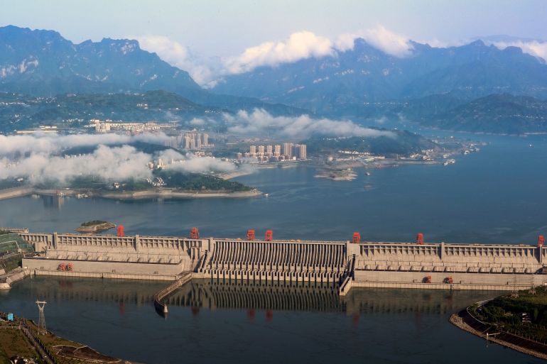
The project on a river that runs through Tibet and India downstream could dwarf the Three Gorges Dam when completed.
China has started building a mega-dam on the Yarlung Zangbo River in Tibet, which could become the world’s largest source of hydroelectric power when completed, according to Chinese officials.
The mega-project in the foothills of the Himalayas will include five hydropower stations on the river, which is also known as the Brahmaputra, further downstream in India, and the Jamuna River in Bangladesh.
China’s Xinhua state news agency reported that Premier Li Qiang attended a commencement ceremony for the dam on Saturday.
Beijing had planned the project for several years, and approval was given in December last year, linking the development to the country’s carbon neutrality targets and economic goals in the Tibet region.
“The electricity generated will be primarily transmitted to other regions for consumption, while also meeting local power needs in Tibet,” Xinhua reported after the groundbreaking ceremony in southeastern Tibet’s city of Nyingchi.
The project is expected to cost an estimated 1.2 trillion yuan ($167.1bn), Xinhua said.
India said in January that it had raised concerns with China about the project, saying it would “monitor and take necessary measures to protect our interests”.
India’s Ministry of External Affairs said at the time that China “has been urged to ensure that the interests of the downstream states of the Brahmaputra are not harmed by activities in upstream areas”.
In December, Beijing’s Ministry of Foreign Affairs said the project would not have any “negative impact” downstream, adding that China “will also maintain communication with countries at the lower reaches” of the river.
China annexed Tibet in 1950, and has built several dams on the region’s rivers, prompting concerns from Tibetans about the potential impacts on the unique ecosystems of the Tibetan Plateau.
Tibet’s vast glaciers and major rivers provide fresh water to 1.3 billion people in 10 countries, according to Yale’s E360 environmental magazine.
The Yarlung Tsangpo is the world’s highest river, reaching some 5,000 metres (16,404 feet) above sea level, and is considered sacred to Tibetans.
The Three Gorges Dam on the Yangtze River in Yichang, Hubei province, China [File Stringer/Reuters]
The new dam is also being built just 30km (18 miles) from China’s vast border with India, much of which is disputed, with tens of thousands of soldiers posted on either side.
Once built, the dam could provide as much as three times as much energy as the Three Gorges Dam on the Yangtze River in central China.
Tibet is much more sparsely populated, with some 2,000 people displaced for the construction of the Yagen Hydropower Station in 2015, according to local media reports.
SEOUL, June 27 (UPI) — South Korea’s Unification Ministry on Friday asked North Korea to give advance notice before releasing water from a dam across the border on the Imjin River, citing safety concerns for residents living in nearby areas.
“We request that North Korea notify us in advance of dam discharges to prevent flood damage in the border area during the rainy season on humanitarian grounds,” ministry spokeswoman Chang Yoon-jeong said at a press briefing. “Joint response to natural disasters is a humanitarian issue, and the South and North have agreed several times to cooperate to prevent flooding in the Imjin River.”
Chang said that the dam issue is directly related to the life and safety of residents in border areas. She noted that an unannounced discharge from the North’s Hwanggang Dam in September 2009 led to damage that killed six South Korean citizens.
The following month, North Korea agreed to provide prior notice before discharging water. Pyongyang sent notices on a handful of occasions in 2010 and 2013, but has not done so since.
The North cut off communications with the South in April 2023, and Chang said sending a message through a press briefing was a form of “indirect communication.”
Recently elected President Lee Jae-myung has said he aims to improve frayed inter-Korean relations. On Wednesday, he called for lasting peace on the Korean Peninsula as both countries commemorated the 75th anniversary of the start of the Korean War.
“The most certain form of security is a state where there is no need to fight — in other words, creating peace,” he wrote in a social media post. “The era of relying solely on military power to protect the country is over. What matters more than winning a war is preventing one.”
He has vowed to restore a military pact aimed at defusing military tensions along the border and reestablish a communications hotline with Seoul’s recalcitrant neighbor.
Earlier this month, Lee ordered the suspension of propaganda loudspeaker broadcasts across the DMZ to North Korea in a bid to reduce tensions with Pyongyang.
While requesting advance notice on Friday, the ministry did not mention the North’s most recent suspected dam discharge.
Seoul’s Environment Ministry warned Wednesday that the water level near Pilseung Bridge on the Imjin River, just south of the inter-Korean border, had risen to 3.2 feet — the threshold for evacuating visitors in the area. The ministry said it believed the result was due to a discharge from the Hwanggang Dam.
As of Friday morning at 8 a.m., the water level at Pilseung Bridge stood at 2.5 feet, the Unification Ministry’s Chang said.
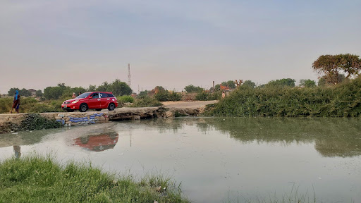
Every weekday, 38-year-old Fatima Musa grips her son’s hand as they step onto a makeshift bridge in Fori, a community in Jere Local Government Area (LGA) of Borno State, northeastern Nigeria. Together, they cross the poorly constructed structure to reach the primary school he attends, and later make the same journey home.
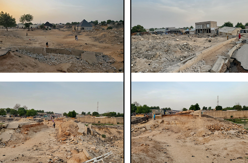
The original Fori Bridge collapsed during the devastating floods of September 2024, which inundated Maiduguri and its environs, leaving dozens dead and thousands displaced. The destruction severed vital connections between Bama Park and Market, the University of Maiduguri, and several neighbourhoods.
With no official intervention, local youths erected a makeshift crossing far from Fatima’s home. Constructed from wooden planks, logs, and sand-filled sacks, the narrow bridge hovers precariously over the Ngadda River, the same river that swept away homes, businesses, and livelihoods just months ago.
The disruption forced residents like Fatima to undertake perilous detours or depend on the makeshift bridge, which is far away from her home.
A car crossing the Fori makeshift bridge. Photo: Abubakar Muktar Abba/HumAngle
The community’s improvised fix has restored a semblance of connectivity, but it is fragile. In less than two months, seasonal rains will return, swelling the Ngadda once again. Residents told HumAngle they fear the structure will be destroyed, cutting them off from schools, hospitals, and markets, and deepening the isolation they already face.
The original Fori Bridge, a vital link for residents across several communities in Jere, was the first structure to collapse when the floods ravaged the area.
A photo collage of the Fori Bridge showing different angles of the destroyed bridge, damaged nearby structures, and large gaping holes that pedestrians carefully manoeuvre around in their daily routines. Photo: Abubakar Muktar Abba/HumAngle
A student’s dread
For 27-year-old Zainab Yahaya, a student at the University of Maiduguri, the broken bridge is more than a daily inconvenience, it threatens her future. She crosses the makeshift bridge every day to attend classes. As the rainy season looms, her anxiety increases.
“I use the makeshift bridge now, but when the water returns, the bridge won’t survive it,” she said. “And then, everything becomes more difficult, more expensive, more dangerous and more exhausting.”
Last year’s flood destroyed her neighbourhood. This year, she fears her education may be next. Without the bridge, Zainab would be forced to take longer detours that significantly increase both cost and travel time.
“What used to cost ₦100 will now jump to ₦400,” she explained. “And the hours I lose taking detours, it’s hard to keep up with school. I will be exhausted before I reach class.”
Crossing by canoe is not an option she trusts. “It’s dangerous. The water is unpredictable, the canoes are unstable, and sometimes you don’t even know if the person paddling them is a professional or not,” Zainab added.
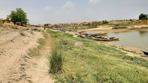
Canoes are parked at the shallow river banks. Photo: Abubakar Muktar Abba/HumAngle
Her frustration is echoed throughout the community. “The government hasn’t done anything tangible. No repairs, no support, not even a visit,” she says. “We’re left on our own.”
A cycle doomed to repeat
A HumAngle investigation published in 2024 traced the flood’s origins to a combination of infrastructural decay, poor planning, and delayed emergency response at the Alau Dam.
Originally designed in 1986 to hold 112 million cubic meters of water, the dam’s capacity has swelled to an estimated 279 to 296 million cubic meters, primarily because of unchecked sediment buildup.
Every year, during the June-to-September monsoon, stormwater flows from the Mubi highlands into the Yedzeram River. This major tributary quickly swells and merges with the Gambole River, before entering the wetlands of the Sambisa Forest to form the headwaters of the Ngadda.
From there, the Ngadda empties into Lake Alau, held back by the Alau Dam, a large reservoir on the outskirts of Maiduguri. When rainfall is heavy upstream, the rivers surge downstream with little delay, raising water levels sharply in Lake Alau.
The dam is gate-controlled, designed to hold and release water in a regulated manner.
However, another dam downstream lacks this control. Without gates, it simply overflows once water reaches a certain level, releasing torrents into vulnerable communities with no warning. This unregulated spillway worsened last year’s catastrophe in Maiduguri.
In February, the federal government announced a ₦80 billion rehabilitation and expansion project for the Alau Dam to prevent any disaster in the future. On March 2, the Minister of Water Resources and Sanitation, Joseph Utsev, officially flagged off the project, stating it would be executed in two phases over 24 months.
Yet, a visit by HumAngle to the site in May painted a different picture.
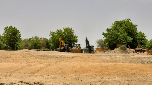
Three bulldozers sat idle in the sun. No workers were present. The dam, still visibly broken, lay open like an unhealed wound. A makeshift sand barrier was the only sign of intervention, containing stagnant water where a flowing river once ran.
Three bulldozers were parked near the dam. Photo: Abubakar Muktar Abba/HumAngle
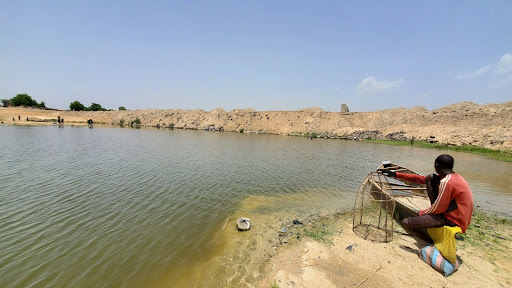
Nearby, fishermen cast their nets into the shallow puddles, making do with what remains of their vanishing livelihood.
“They [referring to government contractors] brought those bulldozers months ago,” said Musa, a wiry young man watching the water. “All they did was pile sand to block the flow. Since then, nothing.”
Adamu, another resident and a fisherman, leaned against a tree and shook his head. “This sand is like candy floss,” he muttered. “It will melt when the floods come. Then we’ll flood again.”
A fisherman gazes at the pond, waiting patiently for a sign from his fish trap. Photo: Abubakar Muktar Abba/HumAngle
At 53, Bulama Isa no longer moves with the vigour of his youth. Yet he frequently walks his farmland along the banks of the Ngadda River, inspecting what remains of his farmland.
“This place used to feed my whole family,” he says, gesturing at the gaping holes where his garden once stood. “Now I don’t have a farm.” Isa has farmed near the Alau Dam since the early 2000s. He watched the flood swallow his fields last September and his year’s harvest. When the water receded, he was left with a gaping hole.
Now, with no compensation and no clear plan from the government, he survives on support from relatives and the little his wife makes selling fried groundnuts.
Residents who spoke to HumAngle expressed frustration over the lack of progress and now fear that this year’s flood could be even worse than the last.
As of May 2025, neither the Fori Bridge nor the Alau Dam has been repaired.
The Nigerian Meteorological Agency (NiMet) has projected that the onset of the rainy season in Borno State will occur between early June and July 2025. In northern states, flooding will likely occur at the peak of rainfall between July and September, according to NiMet. Urban areas with poor drainage systems are particularly at risk of flooding during this period.
HumAngle reached out to the Ministry of Water Resources through the state commissioner, Tijjani Goni Alkali, to inquire about the project’s status and the concerns of nearby communities. As of press time, no response had been received.
With the forthcoming rains, many fear that their lives will be uprooted once again.