Calif

Quickly spreading wildfires trigger evacuations along Calif. coast

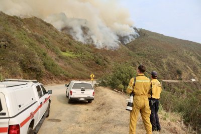
Firefighters survey smoke from the Plaskett Fire burning Saturday in California’s Big Sur region. The fire expanded to more than 15,000 acres and was only 1% contained on Sunday. Photo courtesy California Department of Forestry and Fire Protection

Aug. 30 (UPI) — A pair of wildfires burning along California’s Big Sur region expanded quickly over the weekend, jumping containment lines, closing roads and triggering extensive evacuations.

The Plaskett fire and the Timber fire have been burning for weeks in the rugged terrain of Monterrey and San Luis Obispo counties about 200 miles south of San Francisco.

But strong, gusty winds on Saturday sparked a rapid escalation, prompting officials to close the scenic State Hwy. 1 and issue a series of new evacuation orders after the Plaskett Fire jumped containment lines overnight.

That fire ballooned to nearly 15,500 acres and was only `1% contained as of Sunday afternoon, while the Timber Fire had spread to 24,700 acres and was 21% contained.

Firefighters fought to save structures near Sand Dollar and Plaskett Creek, executing “tactical firing operations overnight as the fire backed toward structures and residences,” according to the California Department of Forestry and Fire Protection, or Cal Fire.

The Plaskett fire crossed over the primary bulldozer containment line, officials said, even as ground teams supported by night flying helicopters fought to put out the “slop-overs.”

Monterrey County officials warned residents of Carmel Valley, Calif., to be ready for possible evacuation orders on Sunday as the fire advanced on the community. A mandatory evacuation order was issued later in day for an area southeast of Salmon Creek Trail and north of the San Luis Obispo County line.

The California Highway Patrol, meanwhile, closed Hwy. 1 just north of the county line, as well as further north at a location south of Little Sur River.
Source link

Ariz., Calif., Nevada face reductions in Colo. River water deliveries

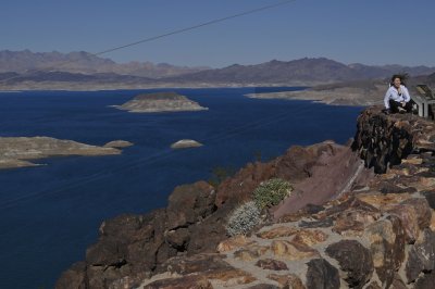
Declining water levels due to climate change and 20 years of ongoing drought have reshaped Lake Mead’s shorelines as seen in this file photo from Nov. 16, 2022. The Department of the Interior on Friday published a new framework under which three Lower Basin states will face reduced water deliveries. File Photo by Jim Ruymen/UPI | License Photo

Aug. 21 (UPI) — Arizona, Colorado and Nevada will see reductions in their water deliveries from the Colorado River by a combined 1.25 million acre-feet per year under a new framework finalized by federal officials on Friday.

Under the new 10-year “Decision Framework” governing the operations of the drought-afflicted Lake Mead and Lake Powell reservoirs along the Colorado River Basin, Arizona implements the largest reduction in deliveries of river water — some 760,000-acre-feet in each of the next two years.

Meanwhile, California will be hit with yearly reductions of 440,000 acre-feet and Nevada would see 50,000 acre-foot declines as state and federal officials grapple with a prolonged drought during which the two reservoirs have reached their lowest-ever recorded levels.

One acre-foot is enough water for as many as four households to use for a whole year.

The cuts represent the largest ever proposed for the three “Lower Basin” states.

The combined contents of Lake Powell and Lake Mead have not been this low since before Lake Powell began filling following the closure of the gates at Glen Canyon Dam in 1963, Interior Secretary Doug Burgum noted in announcing the new framework.

“We are grateful for the seven basin states, the thirty basin tribes, Mexico, and many other basin stakeholders who have provided the feedback and voluntary arrangements necessary for the development of the 2027-2028 operating guidelines.” he said.

“Forty million people, millions of acres of farmland and ranchland, industries that power the American West, and some of our nation’s fastest growing metropolitan areas depend on the Colorado River.”

In addition to the reduction in water deliveries, the framework allows for the three Lower Basin States to voluntarily conserve and store at least 700,000 acre-feet of water over the two-year period to protect the system.

The Colorado River Basin has been experiencing what federal officials have called an “unprecedented multidecadal drought,” resulting in historically low runoff and reservoir levels.

Conditions worsened during 2026, driven in part by the lowest observed snowpack on record during the winter of 2025-2026.

Source link