WASHINGTON — In a simple ceremony attended by their families and a few well-known friends, Sen. Nancy Landon Kassebaum and former Sen. Howard H. Baker Jr. were married Saturday, the first time two people who served in the Senate have ever tied the knot.
“She was beautiful, he was handsome, and they were happy,” said former Tennessee Gov. Lamar Alexander, who attended the wedding with his wife, Honey, at St. Alban’s Church in Washington.
The bride, 64, who is retiring in a few weeks after serving three Senate terms from Kansas, wore a dark purple dress just below knee length, accented by rolled pearls. Baker, 71, who served three Senate terms from Tennessee ending in 1985, wore a navy blue suit, white shirt, and navy tie with small yellow dots.
Viewed through the glass outer doors of the church, the couple clasped hands before the ceremony and then walked together down the aisle of the stone church, which is adjacent to the huge National Cathedral.
The 15-minute ceremony before 80 guests was performed by former Sen. John Danforth of Missouri, an ordained Episcopal priest, and the Rev. Martha Anne Fairchild, a Presbyterian minister from Baker’s hometown of Huntsville, Tenn.
The matron of honor was Kassebaum’s daughter, Linda Johnson. Baker’s son Darek was best man.
After sealing their marriage with a kiss and greeting guests, the newlyweds came outside in a steady, cold rain to talk to reporters. Kassebaum said she wasn’t nervous, but Baker felt a little differently.
“I’ve been nervous for days,” he said.
Aside from their families, guests at the wedding included former First Lady Barbara Bush, former Kansas Sen. Bob Dole and his wife, Elizabeth, former ambassador Robert S. Strauss and former Secretary of State Lawrence S. Eagleburger.
The couple planned a honeymoon, but wouldn’t reveal where they will go.
By midwinter, Los Angeles is defined less by cold than by light. Cool, clear mornings give way to afternoons shaped by the low winter arc of the sun, painting the mountains in long shadows and the sky in improbable color.
And as that low light settles in, my whole body shifts in spirit. Somewhere deep in the limbic system, a synapse fires like a flare, tracing the old circuitry of migration and memory — that annual pull toward the wide-open deserts of the American Southwest.
I dream of lizards, dark skies, sand dunes and sunsets streaked in rose-mauve and smoky violet, the air heavy with the scent of wet creosote and campfire smoke.
A sunrise in the desert.
(Josh Jackson)
But mostly I long for the open road, those forgotten highways where pavement runs through the quaint towns, weathered landmarks and the millions of acres of public land in the desert. It is a nostalgia shared by the chroniclers of the past.
In 1971, Lane Magazine published “The Backroads of California,” a large-format book that delivered trip notes and sketches of 42 backroads by the late artist Earl Thollander.
In the epilogue he writes, “On the backroads of California I re-discovered the pleasure of driving. It had nothing to do with haste, and everything to do with taking time to perceive, with full consciousness, the earth’s ever-changing colors, designs, and patterns.”
Many of those original roads have faded away, swallowed by high-speed highways or erased by suburban expansion. But a handful still survive — routes that don’t carve a straight line but follow the meandering, undulating contours of the land. They are living archives of the West.
This essay marks the beginning of a series exploring those remaining roads. And we begin on Highway 127, a two-lane stretch that runs north from Baker, slowly ascending and descending toward the Nevada border. To the west lies the outskirts of Death Valley National Park; to the east, millions of acres of public land managed by the Bureau of Land Management — acreage collectively owned by all of us.
The Baker Country Store.
(Josh Jackson)
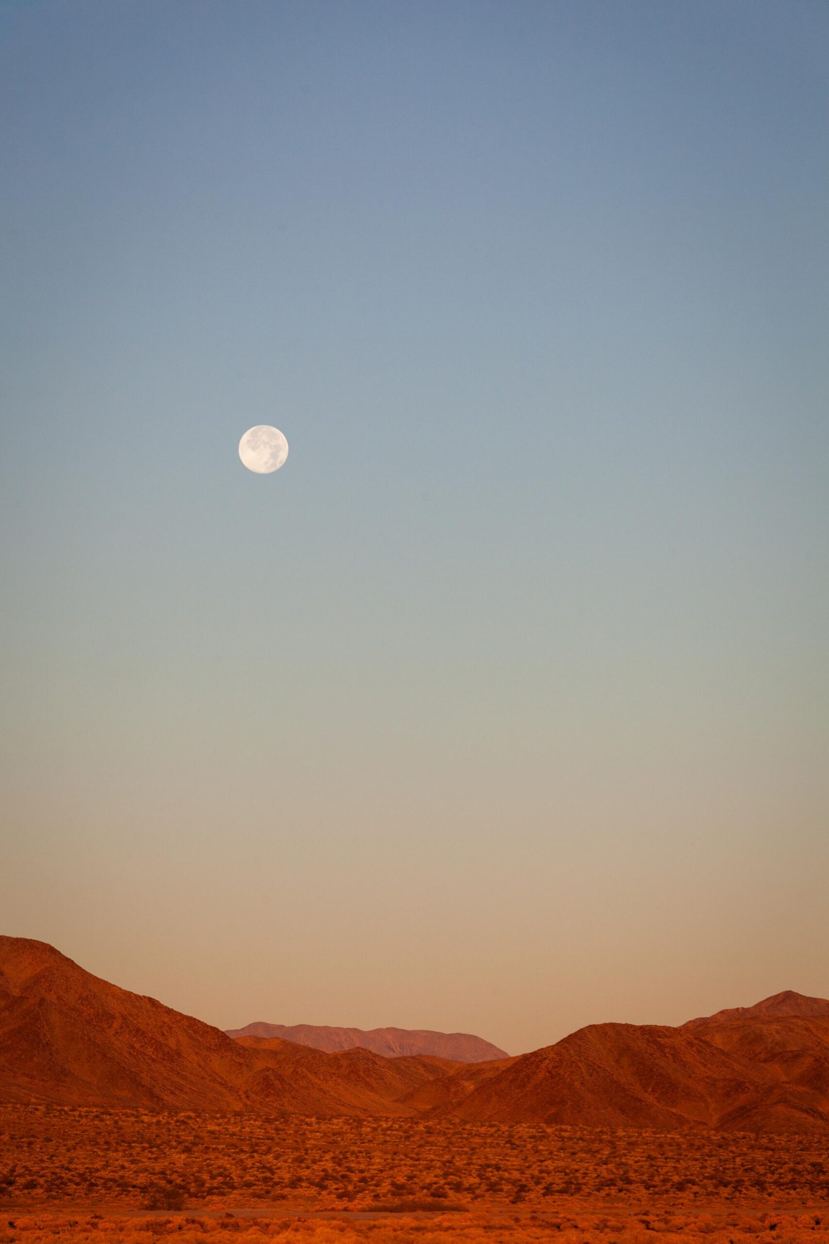
I arrived in Baker at sunrise in early December, camera in hand, notebook in pocket. The highway sign was nearly indecipherable beneath layers of stickers and graffiti.
I pulled the car north out of town, the 41-degree air still holding the night’s chill, and was greeted by shifting light and the open, empty scale of the desert. A full moon was dropping toward the Avawatz Mountains as the sun worked its way over the horizon in the east. The dry lake beds and bare mountains were cast in glow and shadow, the whole scene washed in cinnamon and brown sugar — earthy tones that felt almost edible.
Dumont Dunes, a playground for sand dune enthusiasts, is bordered by the slow-running Amargosa River.
(Josh Jackson)
By mile 34, the winter light had begun to settle over the landscape. A short spur leads to the Dumont Dunes, a popular off-highway vehicle area, but I came to witness the miraculous waterway that surfaces above ground on its 185-mile horseshoe journey from Nevada to Badwater Basin: the diminutive but mighty Amargosa River.
Here it pushes and carves through a canyon of mud walls that resemble the color of a wasp’s nest. Ravens circle overhead, croaking at my presence in defiance. The sight of water in the parched desert unsettles your perceptions. The urge to lie down for a soak, even in winter, is hard to resist. I bend down, scoop a handful of cold water and splash it against my face.
Amargosa Canyon is known for its dramatic rock formations.
(Josh Jackson)
The Amargosa Conservancy and local tribes have worked for decades to protect this river for its cultural and biodiversity values. As Executive Director Mason Voehl told me, it is “the lifeblood of these lands. The fates of every community of life in this extreme reach of the Mojave Desert are inextricably tied to the fate of the river.”
Kneeling at the riverbank, I understood exactly what he meant.
The Shoshone post office.
(Josh Jackson)
Built in the 1930s, the Crowbar Cafe & Saloon is like a time capsule.
(Josh Jackson)
Twenty-two miles farther north, Shoshone appears as a small village serving a couple dozen residents. A gas station, post office, general store and the Crowbar Café & Saloon anchor the town.
I met Molly Hansen, the community’s unofficial historian and naturalist, in her low-ceilinged office near the village center. We walked to the end of town, where spring-fed pools hold the fate of the only population of Shoshone pupfish in the world. Once thought extinct, they were rediscovered in a metal culvert in 1986. Today they dart and shimmer through the warm water — tiny, minnow-like survivors whose breeding males flash a bright desert blue.
Hansen gestured toward the springs. “We’re not just trying to save a species,” she said. “We’re trying to restore the entire ecosystem.”
This ecosystem persists in large part because of Susan Sorrells, who owns the town and surrounding thousand acres. As the lead advocate for the proposed Amargosa Basin National Monument, she is working to protect this entire corridor — the river, wetlands and deep cultural history stitched through these desert valleys. Shoshone might be a tiny dot on a map, but it holds something astonishing: the reminder that the desert doesn’t have to be a place where things go to die — it can be a place where they begin again.
Eagle Mountain.
(Josh Jackson)
Just past mile 72, Eagle Mountain begins to tease the horizon. At first only its serrated top breaches the low hills, as if surfacing for air. Eventually the entire massif stands exposed: a solitary block of limestone rising 1,800 feet above the Mojave floor. Its isolation is striking, a misplaced guardian island.
For the Southern Paiute and Western Shoshone, Eagle Mountain holds profound cultural significance — woven into their creation stories and Salt Songs, understood as a “passage to the sky.” Even with my limited knowledge, the mountain radiated a kind of gravity, as though the desert itself were remembering.
Amargosa Opera House.
(Josh Jackson)
By mile 83, the Amargosa Hotel and Opera House appear — one of the strangest and most enchanting landmarks in the Mojave. Its stucco walls and Spanish arches were once part of a Pacific Coast Borax company town, later abandoned when the boom ended. In 1967, Marta Becket, a professional ballet dancer from New York, serendipitously got a flat tire nearby and fell in love. Soon after, she moved to the outpost, bought the hotel and spent the rest of her life preserving the landmark and restoring the opera house, where she performed for audiences large and small until 2012. Today, the hotel and theater remain open — faded, fragile and utterly magnetic.
The final seven miles of Highway 127 passed quickly, the sun slipping toward the western horizon as I crossed into Nevada, eight hours after I began.
Turns out, Thollander was right: This experience had nothing to do with haste. These backroads teach a different rhythm — the wonders of going the long way, of stopping when something catches your eye, of noticing beauty that doesn’t shout for attention. In a world increasingly defined by speed and distraction, this slow way of seeing becomes more than nostalgia; it becomes an antidote to the frantic pace of our modern condition, a necessary pause to see not what has been forgotten, but what endures.
Road trip planner: California Highway 127
California 127 illustrated map.
(Illustrated map by Noah Smith)
The route: Baker to the Nevada state line
Distance: 91 miles (one way)
Drive time: 1.5 hours straight through; allow a full day for stops
Best time to go: Late October through April. Summer temperatures frequently exceed 110°F
Fuel and essentials:
Baker (Mile 0): Last major services. Fill your tank and stock up on water/supplies here.
Shoshone (Mile 57): Gas station, general store and post office available.
EV charging: Fast chargers available in Baker; Level 2 chargers available at Shoshone Inn.
Food and drink:
Los Dos Toritos Restaurant in Baker: Authentic Mexican.
China Ranch Date Farm (Mile 48): A historic desert oasis along the Amargosa River; famous for date shakes.
Crowbar Café & Saloon in Shoshone: The local watering hole. Hearty meals and cold beer.
Camping:
Dumont Dunes: A wind-shaped sand dune complex designated for off-highway vehicle recreation. Primitive camping (permit required, purchase on-site or online).
Shoshone RV Park: Full hookups, tent sites and access to the warm spring pool.
Lodging:
Hike and explore:
Amargosa River Crossing (Mile 34): Pull out safely to see the rare sight of water flowing in the Mojave.
China Ranch Trails (Mile 48): Creek Trail is an easy, short walk through riparian willow groves; Slot Canyon is a moderate 2-mile hike into spectacular mud-hill geology.
Shoshone Wetlands (Mile 57): Short walking paths to view the Shoshone pupfish habitat.
Amargosa Opera House (Mile 83): Tours of Marta Becket’s painted theater typically run daily (check schedule online); walk the grounds to see the historic borax town ruins.
Safety Notes:
Water: Carry at least one gallon per person per day.
Connectivity: Cell service is spotty to nonexistent between Baker and Shoshone. Download offline maps before leaving I-15.
Wildlife: Watch for wild burros and coyotes on the road, especially at dawn and dusk.