Cat. 4 Melissa regaining strength as it heads for Cuba

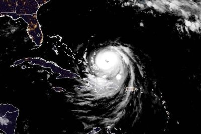
Hurricane Melissa was heading for Cuba late Tuesday as a Category 4 storm. Image by NOAA
Oct. 28 (UPI) — Hurricane Melissa was regaining strength Tuesday night as it was taking aim at Cuba after battering Jamaica throughout the day, forecasters said.
The eye of Melissa was situated about 110 miles southwest of Guantanamo, Cuba, and 300 miles south of the central Bahamas, the National Hurricane Center said in its 11 p.m. EDT update. It was moving northeast at 9 mph.
Melissa had maximum sustained winds of 130 mph, making it a Category 4 storm, and significantly weaker than the Category 5 storm when it hit Jamaica.
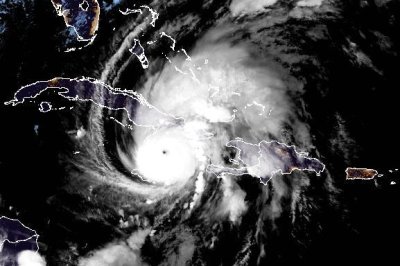
It had lost strength as it traveled over Jamaica’s western mountains, but forecasters said it appeared to be strengthening.
Melissa made landfall as a powerful major hurricane, the strongest direct hit on Jamaica since records have been kept in the Atlantic basin. It was also be the first storm to make landfall in the Caribbean this season.
Melissa is anticipated to make a second landfall along Cuba’s southeastern coast soon, while still maintaining major hurricane strength. It’s also expected to remain a hurricane when it reaches the Bahamas. Bermuda also could be threatened.
“Melissa is expected to continue to strengthen until it reaches Cuba in a few hours, and it is expected to make landfall there as a very dangerous major hurricane,” NHC forecaster John Cangialosi said in a late Tuesday discussion on the storm.
“Melissa is still expected to be a powerful hurricane when it moves through the Bahamas and near Bermuda.”
Catastrophic flash flooding and landslides in parts of southern Hispaniola and Jamaica were expected through early next week.
A hurricane warning was in effect for the Cuban provinces of Granma, Santiago de Cuba, Guantanamo and Holguin; and the southeastern and central Bahamas.
A hurricane watch was in effect for Bermuda.
There was a tropical storm warning for Jamaica, Haiti, Turks and Caicos Islands and the Cuban province of Las Tunas.
Hurricane-force winds extended up to 30 miles from the center, and tropical-storm-force winds extended outward to 195 miles.
Rainfall of 15 to 30 inches through Wednesday was forecast for portions of Jamaica and an additional 6 to 12 inches for southern Hispaniola, which includes Haiti and the Dominican Republic. Jamaica is to get a local maximum of 40 inches, the NHC said.
“Catastrophic flash flooding and numerous landslides are likely,” the NHC said.
Cuba is expected to receive rainfall of 10 to 20 inches, with local amounts up to 25 inches, into Wednesday, “resulting in life-threatening and potentially catastrophic flash flooding with numerous landslides,” the NHC said.
Over the southeastern Bahamas, rainfall is forecast to total 5 to 10 inches into Wednesday with flash flooding in some areas.
Life-threatening storm surge heights could reach 9 to 13 feet above ground level, near and to the east of where the center of Melissa makes landfall and are expected to be accompanied by large and destructive waves, NHC said.
Along the Cuban coast late Tuesday and Wednesday, there is a potential for a significant storm surge of 7 to 11 feet.
And in the southeastern Bahamas and Turks and Caicos Islands, there is the possibility of a storm surge of 4 to 6 feet.
Melissa is the 13th named storm of the season and fifth hurricane. The other Category 5 storms in the Atlantic have been Erin and Humberto.
In September 2019, Hurricane Dorian had maximum sustained winds of 185 mph and devastated the Bahamas islands, including Abaco Islands and Grand Bahama, as a Category 5 storm.
The all-time highest sustained wind speed was Hurricane Allen at 190 mph in August 1980 over the Yucatan Peninsula before weakening to a Category 3 when it struck South Texas.
The most destructive Category 5 storm in the United States was Hurricane Andrew in August 1992, with $27.3 billion in damage. Hurricane Michael, also a Category 5 storm, struck the less populated Florida Panhandle in October 2018.
The United States is not threatened this time.
Hurricane Gilbert struck Jamaica in 1988 as a Category 3 storm.