Humberto

Humberto brings dangerous surf, rip currents to Caribbean, U.S. coast

Hurricane Humberto, which can be seen to the right of Hurricane Imelda, is expected to lose its hurricane strength Wednesday afternoon. Photo courtesy of NOAA

Sept. 30 (UPI) — Forecasters early Wednesday were warning of dangerous surf and “life-threatening” rip currents at beaches of the northern Caribbean, Bahamas, Bermuda and much of the U.S. East Coast as Hurricane Humberto continued its way north across the Atlantic.

With maximum sustained winds of 80 mph, Humberto remained a Category 1 hurricane as of 5 a.m. AST Wednesday, the National Hurricane Center said in its morning update.

The storm was located about 280 miles north-northwest of Bermuda and was moving northeast at 14 mph, the NHC said.

No coastal watches or warnings were in effect, though forecasters continued to warn that its swells could persist for the next few days.

It is expected to move faster toward the east-northeast over Wednesday and remain “a powerful cyclone” until Humberto merges with a developing frontal boundary Wednesday night.

Humberto is the eighth named storm of the Atlantic season and became the season’s third hurricane on Friday morning.

Source link

Humberto weakens to Cat. 3 hurricane

Hurricane Humberto is expected to weaken over the next few days. Photo courtesy of the NOAA

Sept. 30 (UPI) — Humberto weakened to a Category 3 storm on Monday in the Atlantic, according to forecasters, who expected it to continue to lose strength over the next few days.

Humberto had maximum sustained winds of 115 mph, the National Hurricane Center said in its 11 p.m. AST update, a drop of 30 mph in the last 12 hours.

It was located about 265 miles southwest of Bermuda and was moving north-northwest at 14 mph, according to forecasters.

Hurricane-force winds extend outward up to 65 miles from the center of the storm, and tropical-force winds extend outward up to 200 miles.

No watches or warnings were in effect.

“On the forecast track, the center of Humberto will pass west and then north of Bermuda on Tuesday and Wednesday,” the NHC said.

Though the storm is expected to continue on its weakening trajectory, it is forecast to become a “strong extratropical system” in the next few days.

Swells generated by Humberto are likely to cause dangerous surf and life-threatening rip current conditions, affecting beaches of the northern Caribbean, Bahamas, Bermuda and much of the U.S. East Coast for the next few days.

Humberto is the eighth named storm of the Atlantic season and became the season’s third hurricane on Friday morning.

On Sunday, it was joined in the Atlantic by Tropical Storm Imelda.

Source link

Humberto remains major hurricane as it threatens U.S. East Coast

Hurricane Humberto, seen at the right, is expected to vary in intensity over the next day. Photo courtesy of the NOAA

Sept. 29 (UPI) — Humberto strengthened slightly on Monday, bringing threats to the U.S. East Coast and Bermuda, the National Hurricane Center said.

Humberto had maximum sustained winds of 145 mph, the National Hurricane Center said in its 11 a.m. AST update.

It was located about 340 miles south-southwest of Bermuda and was moving northwest at 13 mph, according to the forecasters.

Hurricane-force winds extend outward up to 70 miles from the center of the storm, and tropical-force winds extend outward up to 185 miles.

A tropical storm watch was in effect for Bermuda. While Humberto is expected to miss the island, its residents could begin to feel the effects of tropical-storm-force winds starting late Tuesday, the NHC said.

“On the forecast track, the center of Humberto will pass west and then north of Bermuda on Tuesday and Wednesday,” the NHC said.

The storm is expected to experience fluctuations in intensity over the next day or so, but gradual weakening is forecast after that. It is, however, to remain a “dangerous major hurricane” over the next few days, according to the forecasters.

Swells generated by Humberto will continue affecting portions of the northern Leeward Islands, the Virgin Islands, Puerto Rico and Bermuda through much of this week, and likely produce life-threatening surf and rip current conditions.

Dangerous surf conditions were expected to begin affecting much of the U.S. East Coast on Monday.

Humberto is the eighth named storm of the Atlantic season and became the season’s third hurricane on Friday morning.

On Sunday, it was joined in the Atlantic by Tropical Storm Imelda.

Source link

Humberto remains major hurricane; another system might strike the U.S.

1 of 3 | Hurricane Humberto, right, remained a major hurricane on Saturday morning, while Tropical Depression Nine, left, is forecast to become Tropical Storm Imelda by Sunday morning. Photo courtesy of the NOAA

Sept. 27 (UPI) — Humberto weakened to a Category 4 hurricane Sunday, but remains a threat to the East Coast and Bermuda this week, the National Hurricane Center said.

Humberto had maximum sustained winds of 145 mph, was located about 525 miles north-northwest of the Northern Leeward Islands and about 470 miles south-southeast of Bermuda, and was moving west-northwest at 10 mph, the National Hurricane Center reported in its 5 p.m. EDT update.

Hurricane-force winds extend outward up to 25 miles from the center of the storm, and tropical-force winds to 125 miles outward.

No coastal watches or warnings are in effect, but the NHS advises officials in Bermuda to monitor Hurricane Umberto’s progress.

Hurricane Humberto likely will retain its major hurricane status for the next several days and turned to the northwest on Sunday, and is projected to make another turn to the north by Tuesday, according to the NHC.

Swells generated by Humberto will start affecting portions of the northern Leeward Islands, the Virgin Islands, Puerto Rico and Bermuda beginning Sunday night, where the hurricane likely will cause life-threatening surf and rip current conditions.

The NHC shows Bermuda in the storm’s cone on Tuesday.

Humberto is the eighth named storm of the Atlantic season and became the season’s third hurricane on Friday morning.

Tropical Depression Nine could threaten southeastern U.S.

The NHC also is tracking Tropical Depression Nine on Saturday morning and expects it to strengthen to tropical storm status by late Saturday night, which would be named Tropical Storm Imelda.

The tropical depression had maximum sustained winds of 35 mph and was moving northwesterly at 5 mph while located about 200 miles northwest of the eastern tip of Cuba and about 105 miles south-southwest of the Central Bahamas, according to the NHC’s 5 p.m. EDT update.

“Strengthening is expected during the next few days, and the system is forecast to become a tropical storm tonight or early Sunday and a hurricane by late Monday or Tuesday,” the NHC update said.

A tropical storm watch was issued for Florida’s east coast from the Palm Beach/Martin County line north to Flagler/Volusia County line.

A tropical storm warning is in effect for the Central Bahamas and San Salvador, while a tropical storm watch is in effect for portions of the northwest Bahamas.

Moving north-northwest through Monday, the storm is expected to track across the central and northwestern Bahamas on Sunday and approach the U.S. coast early next week, according to the NHC.

Eastern Cuba is expected to see 8 to 12 inches of rain with the potential for up to 16 inches in isolated areas, while the Bahamas is predicted to see 4 to 8 inches of rain, forecasters said.

Between 2 and 4 inches of rain is forecast across Hispaniola, Jamaica, and portions of central and southern Cuba.

“This rainfall will likely produce flash and urban flooding,” NHC said. “Mudslides are also possible in areas of higher terrain across eastern Cuba, Hispaniola and Jamaica.

Swells generated by the cyclone, as well as Hurricane Humberto, will affect parts of the Bahamas this weekend and are predicted to spread to the southeast U.S. coast early next week.

The potential for swells could cause life-threatening surf and rip current conditions, NHC said.

Source link

Humberto remains major hurricane as another storm threatens

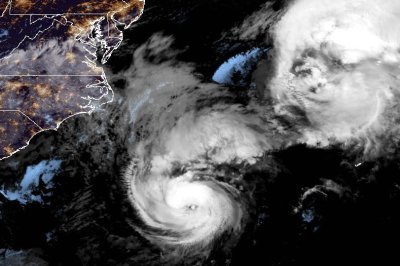
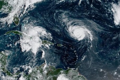
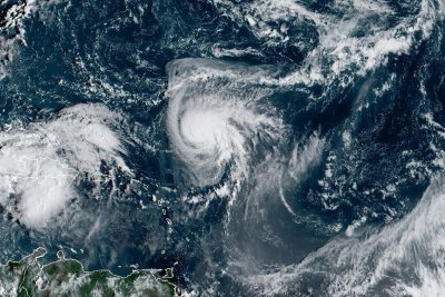
1 of 3 | Hurricane Humberto (R) remained a major hurricane on Saturday morning. Potential Tropical Cyclone Nine (L) is forecast to become Tropical Storm Imelda early Sunday. Photo courtesy of NOAA

Sept. 27 (UPI) — Humberto remained a major hurricane Saturday morning and is headed to Bermuda as another potential storm later threatens Cuba, the Bahamas and the eastern United States, the National Hurricane Center said.

Humberto, the eighth named storm of the Atlantic season, had maximum sustained winds of 145 mph as a Category 4, with additional strengthening forecast through the weekend, NHC officials said in a 5 a.m. EDT update. Humberto became the season’s fourth hurricane on Friday morning.

The eye of the storm was located about 375 miles northeast of the northern Leeward Islands. It was moving northwest at 6 mph.

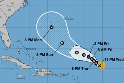
The forecast track has Humberto moving northward at a slightly faster forward speed through the weekend with a turn north-northwest on Monday night.

Swells generated by Humberto will start affecting portions of the northern Leeward Islands, the Virgin Islands, Puerto Rico and Bermuda this weekend, NHC said. They are likely to cause life-threatening surf and rip current conditions.

“As Humberto gains latitude, a significant expansion in the surface wind field will likely occur while it passes west of Bermuda,” NHC forecaster Lisa Bucci said in a discussion.

NHC shows Bermuda in NHC’s cone early Wedesday as a major storm. Humberto will move eastward out to sea on Thursday.

No coastal watches or warnings were in effect as of Saturday morning.

Hurricane-force winds extend outward up to 25 miles from the center of the storm, and tropical-force one outward to 105 miles.

Humberto became the Atlantic hurricane season’s eighth named storm on Wednesday. It’s the third hurricane after Erin and Gabrielle.

In August, Erin intensified into a Category 5 hurricane with 160 mph winds spreading across a 500-mile area. It did not make landfall in the United States but caused dangerous surf, rip currents and coastal flooding along the East Coast, with the worst conditions in North Carolina and Virginia.

Gabrielle formed in mid-September and also became a major hurricane, a Category 4. The storm dissipated into a post-tropical cyclone near the Azores on Friday.

Tropical Storm Chantal was the only storm to make landfall in the U.S. — South Carolina on July 6.

By Sept. 27 last year, there were 10 named storms with one other storm forming later in September.

Potential tropical cyclone

Another storm of concern in the Atlantic is Potential Tropical Cyclone Nine, which is forecast to become a depression on Saturday night and Imelda early Sunday. A hurricane is projected for Monday night east of Florida’s northern coast.

In the 8 a.m. EDT NHC advisory, the storm had maximum sustained winds of 35 mph and was about 170 miles northwest from the tip of Cuba and about 180 miles south of the Central Bahamas. It was moving northwest at 9 mph.

A tropical storm warning is in effect for the Central Bahamas and San Salvador, while a tropical storm watch is in effect for portions of the northwest Bahamas.

Moving north-northwest through Monday, the storm is expected to track across the central and northwestern Bahamas this weekend and approach the U.S. coast early next week. Eastern Cuba is expected to see 8 to 12 inches of rain with the potential for up to 16 inches of rain in isolated areas, which the Bahamas is predicted to see 4 to 8 inches of rain, forecasters said.

“Moisture from the disturbance will lead to a threat of heavy rainfall well to the north across portions of the Southeast U.S. and Virginia into early next week which could cause flash, urban, and river flooding,” NHC said.

Swells generated by the cyclone, as well as Hurricane Humberto, will affect parts of the Bahamas this weekend and are predicted to spread to the southeast U.S. coast early next week. The potential for swells could cause life-threatening surf and rip current conditions, NHC said.

Source link

Humberto strengthens into hurricane, could impact Bermuda

Hurricane Humberto is expected to intensify into a major hurricane sometime Saturday. Photo courtesy of NOAA

Sept. 26 (UPI) — Humberto strengthened into a hurricane Friday morning and could reach major hurricane status by the weekend, the National Hurricane Center said.

The eye of the storm was located about 465 miles northeast of the northern Leeward Islands. It had maximum sustained winds of 75 mph and was moving northwest at 3 mph, the NHC said in its 5 a.m. AST update.

The forecast track has Humberto moving northward toward the island of Bermuda in the coming days.

The NHC described Humberto as “better organized” over the previous several hours, with signs of “steady-to-rapid intensification.”

No coastal watches or warnings were in effect.

Humberto became the Atlantic hurricane season’s eighth named storm Wednesday. It’s the third official hurricane after Erin and Gabrielle.

In August, Erin intensified into a Category 5 hurricane with 160 mph winds spreading across a 500-mile area. It did not make landfall in the United States but caused dangerous surf, rip currents and coastal flooding along the East Coast, with the worst conditions in North Carolina and Virginia.

Gabrielle formed in mid-September and also became a major hurricane, a Category 4. The storm dissipated into a post-tropical cyclone near the Azores on Friday.

Tropical Storm Chantal was the only storm to make landfall in the U.S. — South Carolina on July 6.

Source link

Tropical Storm Humberto forms in Atlantic as eighth named storm

Tropical Storm Humberto is forecast to become a hurricane early Saturday and a major one by Sunday night. Image by National Hurricane Center

Sept. 24 (UPI) — Tropical Storm Humberto, the eighth named storm of the 2025 Atlantic hurricane season, formed Wednesday afternoon and is forecast to become a hurricane by Saturday and ultimately a major one, the National Hurricane Center said.

In a 5 p.m. EDT posting, NHC said Humberto became a tropical storm with maximum sustained winds of 40 mph, which is 1 mph below the minimum to be classified as a tropical storm. Six hours later, NHC said it had maximum sustained winds of 45 mph. A storm became a hurricane with winds at least 74 mph.

At 11 p.m., Humberto was about 505 miles east-northeast of the Northern Leeward Islands and was moving west-northwest at 12 mph.

NHC said the storm is expected to continue in the same direction over the next few days but with a lower forward speed.

“It may intensify into a hurricane late this weekend or early next week,” Alex DaSilva, AccuWeather lead hurricane expert, said.

NHC forecasters Richard Pasch and Eric Blake said in a discussion: “The system will probably become a hurricane in a couple of days, and then strengthen into a major hurricane.”

Humberto is forecast to pass between Bermuda and the U.S. East Coast.

“Towards the end of the forecast period, an approaching trough moving offshore the East Coast of the United States will erode the ridge and allow the system to turn more northward,” NHC forecaster Larry Kelly said in a discussion. “However, there is quite a bit of uncertainty with the forward speed and cross-track spread of the system.”

Tropical storm-force winds extend outward up to 105 miles, NHC said.

No coastal watches or warnings are in effect.

Of the eight named storms, two became hurricanes, both major.

In August, Erin intensified into a Category 5 hurricane with 160 mph winds spreading across a 500-mile area. It did not make landfall in the United States but caused dangerous surf, rip currents and coastal flooding along the East Coast, with the worst conditions in North Carolina and Virginia.

Gabrielle formed in mid-September and also became a major hurricane, a Category 4. In the 3 a.m. GMT update Thursday, Gabrielle had maximum sustained winds of 85 mph as a Category 1 storm and was about 855 miles west of the Azores.

Tropical Storm Chantal was the only storm to make landfall in the U.S. — South Carolina on July 6.

Source link