Floris

Storm Floris clear up after power cuts and travel disruption

Reuters A man in a hi vis vest and orange hat stands behind a fallen tree on a road.Reuters

A worker removes a fallen tree on the A82 at Onich near Fort William

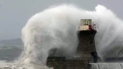
Storm Floris disruption is expected to continue on Tuesday as the clear-up continues after the amber weather alert.

Scottish and Southern Electricity Networks (SSEN) said it was continuing to restore supplies after about 50,000 homes were left without power.

Network Rail said teams had been working “tirelessly” to clear routes with 119 incidents reported on train lines across Scotland on Monday, amid gusts of up to 90mph in some parts.

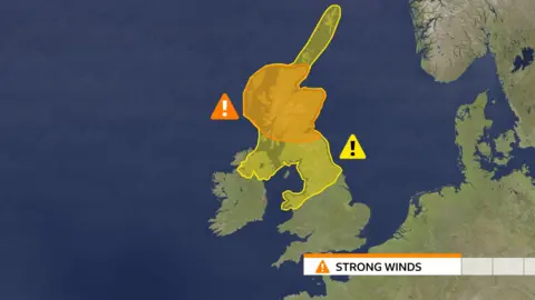
Winds of up to 70mph were expected overnight in Orkney and Shetland, with a Met Office yellow warning in place until 08:00.

The Scottish government held an emergency meeting on Monday night in response to the “significant disruption” caused by the storm.

Home Affairs Secretary Angela Constance said travel should be avoided if possible until the danger had passed.

She said that power cuts were still affecting a “significant” number of properties, and that the recovery period would take time despite an improving forecast over the rest of the week.

“We will continue to receive updates throughout Tuesday and will have a better idea on public transport tomorrow morning,” she added.

ScotRail urged customers to check their journey via the app, website or JourneyCheck before travelling on Tuesday.

SSEN said Floris was “the most damaging summer storm in recent memory” with thousands of properties hit in the Highlands, Moray and Aberdeenshire.

Damage and disruption as Storm Floris crashes into UK

About 9,000 homes had been reconnected by Monday night, with SSEN engineers working to restore power to 43,500 more.

The firm said free hot food and drinks would be provided on Tuesday in areas where homes were awaiting reconnection.

Confirmed food locations are:

  • DINGWALL – Maryburgh Hub Hall
  • HUNTLY – Market Muir Car Park
  • WICK – Bilbster Hall
  • LAIRG -Village car park
  • KYLE OF LOCHALSH – Lochalsh Leisure Centre

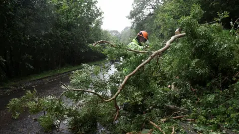
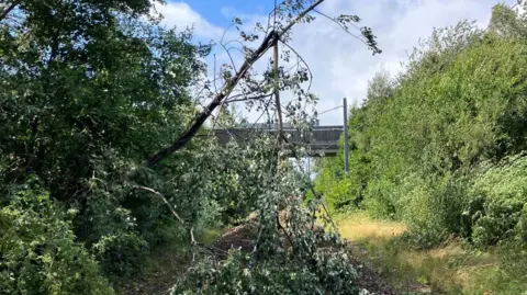
Network Rail reported 75 tree-related incidents across the network, including trees falling on to overhead lines at King’s Park in Glasgow, Cornton near Stirling and Bishopton near Paisley.

It said some train disruption would continue as checks were carried out on Tuesday morning.

Network Rail Scotland A broken tree fallen onto a train track with a thin trunk splintered over an overhead line below a blue cloudy skyNetwork Rail Scotland

In Clackmannanshire, Network Rail cleared trees from lines near Alloa

Ross Moran, Network Rail Scotland’s route director, said: “Storm Floris has caused significant disruption to Scotland’s railway.

“As the storm passes our focus switches to inspecting routes which have been closed by fallen trees, debris and other damage.

“We’ll use two helicopters to assist engineers on the ground. We’re grateful to passengers for their patience whilst we do this.”

Flights and ferries were also suspended across Scotland on Monday with people urged to avoid travel.

Most of the country’s major road bridges were closed to high-sided vehicles.

Vehicles were blown over in Glasgow and Skye, while the Royal Edinburgh Military Tattoo and other major events were cancelled.

PA Media A crowd of about 20 people on a windy cobbled street, a woman holds down her hat while another woman has her hood blown from her head. Staff in high vis vests stand at a metal barrier.PA Media

Visitors were turned away from Edinburgh Castle after it closed on Monday

Edinburgh Fringe Festival said about 110 shows had been cancelled – mostly those in temporary structures.

In Glasgow, location filming for the superhero blockbuster Spider-Man: Brand New Day was suspended in the city centre.

The SQA also warned that the weather would delay the delivery of exam results letters on Tuesday for pupils on Scotland’s islands.

A Met Office amber warning, covering a wide area from the central belt to the Highlands, expired at 23:00 on Monday.

Western coastal areas saw the strongest early gusts with the high winds moving north-east later.

The Met Office said summer storms caused problems as trees were in full leaf and were more likely to be toppled with branches broken off.

Tuesday is forecast to be a calmer day as Storm Floris moves towards Scandinavia.

Source link

Storm Floris amber weather warning issued ahead of strong winds hitting UK

Elizabeth Rizzini

Lead Weather Presenter

PA Media Large wave crashing against a lighthousePA Media

Weather warnings have been upgraded to amber for most of Scotland as Storm Floris bears down on the UK.

The warning lasts from 10:00 BST on Monday through to 22:00 and warns of danger to life as damage to buildings and trees due to storm conditions is expected.

There is also a yellow warning across northern England, north Wales and Northern Ireland from 06:00 BST on Monday through to midnight.

Storm Floris is the sixth named storm of the 2024/25 season, and the first since January.

The storm is yet to develop but there will be a rapid drop in pressure as the system nears British shores on Sunday night.

It is expected to bring “unusually strong” west or north-westerly winds to much of Scotland.

The amber warning covers a wide area as far south as the country’s central belt – including Glasgow and Edinburgh and also the Highlands.

Gusts of 50 to 70mph are expected, even inland. Exposed coasts, hills and bridges could see gusts of 80 to 90mph, while some models have even suggested 100mph gusts which were last seen during Storm Éowyn in January.

The worst of the winds will be in the western coastal areas of the warning zone between late morning and early afternoon.

As the storm spirals away by late afternoon and early evening the strongest winds will move further eastwards to coastal areas of Aberdeenshire.

Trees are in full leaf at this time of year and are more likely to be toppled with branches broken off than during winter when the wind can whistle through them unimpeded.

Power disruption is also possible while heavy rain and flooding could be an additional hazard.

Weather graphic showing the areas covered by the yellow and amber warnings

The area affected by the yellow warning includes Yorkshire and Humber, north Wales, North West England, North East England, Northern Ireland and all of Scotland including Orkney and the Shetland Islands.

Many inland areas are likely to see gusts of 40 to 50mph with 60 to 70mph possible along exposed coasts and high ground.

Scottish Transport Secretary Fiona Hyslop said a meeting had been held on Friday to ensure Scotland was ready for the storm.

“Given the unusual timing, and the fact some people will be on holiday, travelling or perhaps unaware, we are trying to raise even more awareness than usual of this potentially disruptive storm.”

She added: “This is a slightly unusual situation for August, however the message is the same as winter – plan ahead, check your journey in advance, allow extra time and don’t take any unnecessary risks.”

National Rail has warned that speed restrictions are likely and warned journey delays and cancellations are possible.

Strong winds can also bring down trees that block tracks and damage power lines.

Scottish ferry operator CalMac has issued a series of cancellation warnings ahead of the storm.

In a post on X it said: “Disruption to sailings is expected across our network on Monday, August 4 due to forecasted strong winds across parts of Scotland’s west coast.”

Meanwhile, motorists are urged to slow down in poor weather and avoid exposed Highland and coastal routes.

Rod Dennis, from breakdown service RAC, said: “It’s the height of the holiday season, so those towing trailers and caravans, as well as those with roof and tent boxes, must ensure their loads are properly secured.”

Named storms in August are not that rare.

Last year, Storm Lilian struck the UK on 23 August just before the bank holiday weekend, closing stages at the Leeds Festival and cancelling Heathrow flights.

In 2023, Storm Antoni brought wet and very windy weather to south Wales and south-west England affecting events such as Brighton and Plymouth Pride. Less than two weeks later Storm Betty brought further disruption.

In 2020 there were also two August storms – Ellen and Francis – that the Met Office describes as “two of the most notable August storms in the last 50 years”.

These two storms brought wind gusts of 79mph and 81mph respectively with transport disruption, coastal flooding and power cuts.

The storm follows the UK’s fifth warmest July on record, according to provisional figures from the Met Office.

All four UK nations recorded one of their 10 warmest Julys, and July was the sixth consecutive month of above-average mean temperatures for the UK, the Met Office said.

The first day of the month brought the highest temperature of the year so far, with 35.8C in Faversham, Kent.

Source link