3 hikes near L.A. where wildflowers are thriving right now
I went to the Santa Monica Mountains on the hunt for wildflowers.
I was nervous. What if I found absolutely nothing? I’d used data collected by plant lovers during previous blooms and checked on iNaturalist, a citizen science app, about where wildflowers had recently been noticed to discern where I’d be most likely to find blooms.
But, even then, I knew the unusual spring heat wave that prompted some wildflowers to bloom early could have also killed them. I knew the heat had already zapped the bright orange beauties at the Antelope Valley California Poppy Reserve. What if I’d already missed this annual springtime magic?
It was with this level of eagerness and anxiety I recently entered the Santa Monica Mountains. I feel more than lucky to have discovered a resplendent rainbow of native plant blooms.
I hope you also witness this abundance on the three trails below. L.A. is forecast to have more springtime rain, and you know what they say about April showers!
If not, though, I want to underscore that regardless of their foliage, each hike offers its own unique adventure, one I’d take in any season.

Chaparral bird’s-foot trefoil blooms in thick patches throughout the Saddle Peak Trail.
(Jaclyn Cosgrove / Los Angeles Times)
1. Saddle Peak via Backbone Trail
Distance: 3.3 miles out and back
Elevation gained: About 860 feet
Difficulty: Moderate
Dogs allowed? No
Accessible alternative: Inspiration Loop Loop ADA Trail at Will Rogers State Historic Park
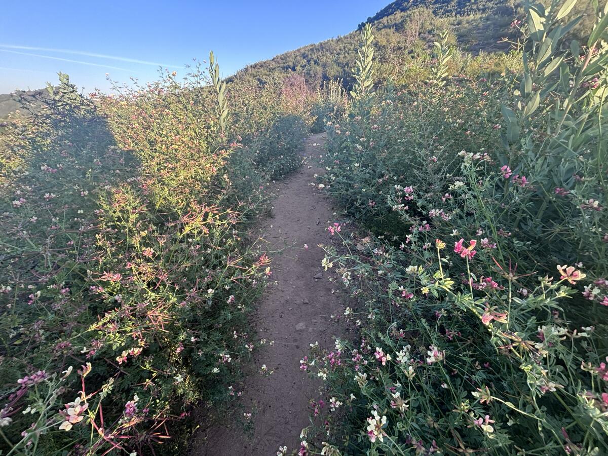
This 3.3-mile route to Saddle Peak takes hikers up a lush hillside with sweeping views of the nearby Calabasas Peak, the San Fernando Valley and, toward the top, the Pacific Ocean. Visitors will observe a landscape that features not only a diversity of wildflower species but also ancient sandstone formations.
You’ll start your hike by parking on the side of Stunt Road, a winding paved street with sharp turns popular among cyclists and drivers of very fast sports cars. There is limited parking here, so it’s good to either arrive early or hike this trail on a weekday. Additionally, the parking area on the side opposite the trailhead is near a steep drop-off so take good care if parking there.

The Saddle Peak Trail features multiple stretches where wildflowers grow close to the trail.
(Jaclyn Cosgrove / Los Angeles Times)
The trailhead sits just south of the road and is well-marked with large signs, including one that warns you that smoking, bicycles and dogs are prohibited on the trail. (Apologies to your cigar-loving circus canine.)
You will first take the short Stunt Road connector trail about 0.2 miles before bearing left, or east, onto the Backbone Trail to Saddle Peak. You’ll immediately start noticing wildflowers.

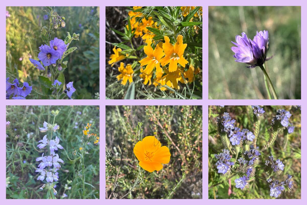
Chaparral bird’s-foot trefoil, clockwise, mini lupine, purple nightshade, showy penstemon, golden yarrow and large-flowered phacelia.
(Jaclyn Cosgrove / Los Angeles Times)
I have dubbed myself a “lupine freak” because of my obsession with this genus of plants — not because I enjoy howling at the moon once a month — and I paused just a third of a mile into this trail. “You look like a tiny little lupine,” I said to the short plant with purplish blue petals near my right foot. Turns out it was indeed a miniature lupine!
This would be the first of many delights. Within a half mile on the trail, I’d already spotted golden yarrow, bush poppy, purple nightshade and black sage abundant with purple blooms. And canyon sunflower covers substantial portions of this trail. This suggests the trail burned in recent years, as canyon sunflower is a fire follower.
There’s also a fair amount of California sagebrush, which you can run your fingers along and smell its delicious aroma (which I think smells like spicy Italian salad dressing).

The view from a bench at a lookout point near the Saddle Peak Trail in the Santa Monica Mountains.
(Jaclyn Cosgrove / Los Angeles Times)
As I hiked onward, I started to feel like Julie Andrews in “The Sound of Music” because the hills really were alive! I squinted at one plant I had no memory of seeing, a pink and green plant with bright pink and lemon chiffon-colored petals. Had I finally stumbled upon one of California’s rare, threatened or endangered plants?
I was so eager to Google this floral mystery. Later, I learned it’s a not-so-rare (but oh-so-beautiful) chaparral birdsfoot trefoil. It grew thick throughout the second leg of this trail, a real visual feast!
I briefly hiked through a lull where the trail was beautiful but not bursting with colors outside green and brown. Then, I came around another corner to find more trefoil, large-leaf phacelia and showy penstemon, which would be a great native plants-inspired drag performer name.

A massive sandstone rock wall along the Saddle Peak trail.
(Jaclyn Cosgrove / Los Angeles Times)
Very suddenly, after staring at plants for more than an hour, I looked up and realized I’d reached the massive ancient boulders. I watched as white-throated swifts dived in and out of the rock’s pockets where it might be considered tafoni (maybe!). Fun fact: These birds use “their saliva to glue a little cup of twigs and moss to the vertical wall” to build their nests, according to Cornell Lab of Ornithology.
You’ll take a few well-maintained sets of rock steps up, also navigating some rocky and, at times, somewhat washed-out portions of the trail. Take good care to look before you reach toward a rock for leverage so you don’t end up grabbing a danger noodle (read: snake).
About 1.3 miles in, you will crest a hill and be greeted with gorgeous views of the deep-blue ocean. From here, you can continue up to Saddle Peak, which features more massive rock formations.
I hiked over to a bench at an overlook point just past a few (invasive but pretty) Spanish broom plants. Here, I took stock of the day, savoring both the burrito I packed and the good day I’d had. I don’t know whether anyone would label it “super,” but I found myself chuckling over simply calling it a superb bloom.

The Musch Trail in Topanga State Park.
(Jaclyn Cosgrove / Los Angeles Times)
2. Backbone Trail to Musch Trail Camp
Distance: 2 miles out and back (with option to extend via a loop back)
Elevation gained: About 200 feet
Difficulty: Easier end of moderate
Dogs allowed? No
Accessible alternative: Musch Trail road, a 0.6-mile out-and-back trek on a paved path from the parking lot
This two-mile, out-and-back jaunt through Topanga State Park takes you through lush meadows and chaparral where you’ll be near destined to spot wildflowers and wildlife.
To begin your hike, you’ll park at Trippet Ranch and pay to park before heading out. The Musch Trail starts in the northeast corner of the lot. You’ll take the paved path just 1/10 of a mile before turning east onto the dirt path, the Backbone Trail.

Caterpillar scorpionweed with southern bush monkeyflower nearby, clockwise, purple owl’s clover, canyon sunflower, dodder over black sage, California poppy and western blue-eyed grass.
(Jaclyn Cosgrove / Los Angeles Times)
The ranch was originally called Rancho Las Lomas Celestiales by its owner Cora Larimore Trippet, which translates to “Ranch of Heavenly Hills.” You’ll find, as you hike through those hills covered in oak trees, black sage, ceanothus and more, that the name still rings true today.
I also spied significant blooms of orange-yellow southern bush monkeyflower, canyon sunflower, golden yarrow, a species of Clarkia, light purple caterpillar scorpionweed and exactly one blooming California poppy plant (just past the pond).
A mile in, you’ll arrive at Musch Trail Camp, a small campground with picnic tables and log benches. As you pause, listen to the songs of the birds. California quail, Anna’s hummingbird and yellow-rumped warbler are commonly spotted. Stay quiet enough, and you might just spot a mule deer, desert cottontail or gray fox. On a recent visit, I went to refill my water bottle at a spigot next to the camp, only to discover a Southern alligator lizard lounging in the path.
From the trail camp, you can either turn around or continue northeast to Eagle Rock, which will provide panoramic views of the park. From Eagle Rock, many hikers take Eagle Springs Fire Road to turn this trek into a loop. Regardless of which path you take, please make sure to download a map beforehand.

As the sun sets, golden light blankets the hillsides in Leo Carrillo State Park.
(Jaclyn Cosgrove / Los Angeles Times)
3. The Willow Creek and Nicholas Flats Trails
Distance: 1.9 miles with an option to extend
Elevation gained: About 630 feet (excluding extension)
Difficulty: Moderate
Dogs allowed? No
Accessible alternative: Sycamore Canyon Road
This 1.9-mile loop is a mostly moderate jaunt connecting two popular routes in Leo Carrillo State Park. As a bonus, you can head over to the beach after your hike, either to cool down, explore the tide pools or both!
To begin, you’ll park at Leo Carrillo State Park. An all-day pass is $12, payable to the ranger at the gate or via the machine in the parking lot. Once parked, you’ll head northeast to the trailhead. You’ll quickly come to a crossroads. Take the Willow Creek Trail east to officially start your hike.
You’ll gain about 575 feet in a mile as you traverse the Willow Creek Trail. I took breaks along the way to gaze at the ocean, watching surfers bobbing on their boards and a kite surfer trying to gain traction. You might spot coast paintbrush and California brittlebush, a flowering shrub that features yellow daisy-like flowers, on the path, along with several lizards.

California poppies growing amid invasive weeds, left, Coulter’s lupine and longleaf bush lupine observed in Leo Carrillo State Park last May.
(Jaclyn Cosgrove / Los Angeles Times)
A mile in, you’ll come to a junction in the trail where you have three-ish options. You can continue west to a branch of the Nicholas Flat Trail that will take you a mile back down to the parking lot. You can head south onto an ocean vista lookout point (which, though steep, I highly recommend). Or you can turn north onto another branch of the Nicholas Flat Trail.
I did a combination, hiking 235 feet up the lookout path, where I had one of those “Wow, I get to live here” moments. The ocean was varying shades of blue, from turquoise to cerulean to cobalt. I could clearly see in all directions, including about eight miles to the east to Point Dume. I was, once again, amazed to be alone in a beautiful place in a county of 10 million people.
Once I finished at this awe-inspiring point, I headed north onto the Nicholas Flat Trail, taking it about 2.3 miles — and about 1,100 feet up 🥵 — through laurel sumac and other coast sage scrub vegetation into the Nicholas Flat Natural Preserve. Along the way, keep an eye out for deerweed covered in its orange and yellow flowers along with scarlet bugler (which hummingbirds love). Other common sights here include Coulter’s lupine and small patches of California poppies.
If you start this hike early enough in the day, you can simply trek back to your car and change into your swimsuit for an afternoon at the beach. And if the tide is out, you might also be able to walk around the tide pools. You could hang out in the same day with both lizards and starfish, and even spy an endangered bumblebee on the trail and an octopus at the beach.
Please, go have yourself a remarkable Southern California day!

3 things to do

A person takes in the sunset on the beach in Venice.
(Michael Blackshire / Los Angeles Times)
1. Watch the sunset with new friends in Venice
Sunset Club L.A. will host a free community gathering at 6:15 p.m. Thursday at Venice Beach. Guests will meet in front of Fig Tree (431 Ocean Front Walk #2402) before setting up camp on the nearby beach to watch the sunset together. Learn more at the club’s Instagram page.
2. Take a peaceful jaunt in L.A.
L.A. for the Culture Hiking Club will host an adventure at 10:30 a.m. Saturday through Griffith Park. The group will take a 2.6-mile hike that includes the Ferndell Nature Trail. Afterward, guests will hang out at the Trails Cafe near the trailhead. Register at eventbrite.com.
3. Find a new kind of ‘dume’ scrolling in Malibu
California State Parks needs volunteers to help remove invasive plants from 9 a.m. to noon Saturday at Point Dume. Park workers will guide participants on removing weeds while cultural resource staff will teach volunteers about the ecological and cultural importance of the site. Register at eventbrite.com.

The must-read

The Griffith Park Pool has remained fenced in and closed for six years, but there are plans now to renovate and reopen the pool.
(Gina Ferazzi / Los Angeles Times)
Who is ready to take a dip at the Griffith Park historic swimming pool? That might become a reality by July 2029. Times staff writer Christopher Reynolds wrote that city officials aim to give the facility at Riverside Drive and Los Feliz Boulevard, which dates to 1927, a three-year, $40-million facelift. The new design will feature two new pools and rehabilitate the site’s pool house. Officials closed the pool in early 2020 amid COVID-19 shutdowns and later discovered when they tried to refill it that the pool wouldn’t hold water.
I cannot wait to take a hike and then a swim at the same public park!
Happy adventuring,

P.S.
Are you ready to transition from hiking around native wildflowers to planting them? Come meet experts from the Theodore Payne Foundation and the California Native Plant Society at the L.A. Times Plants Booth during The Times’ Festival of Books at USC on April 18 and 19. If you sign up for the L.A. Times Plants newsletter, you’ll receive Jeanette’s Mix, a special packet of sunflower and California poppy seeds named for our beloved L.A. Times plants writer Jeanette Marantos, who died in February. I am volunteering at the booth on April 18 and would love to meet you!
For more insider tips on Southern California’s beaches, trails and parks, check out past editions of The Wild. And to view this newsletter in your browser, click here.