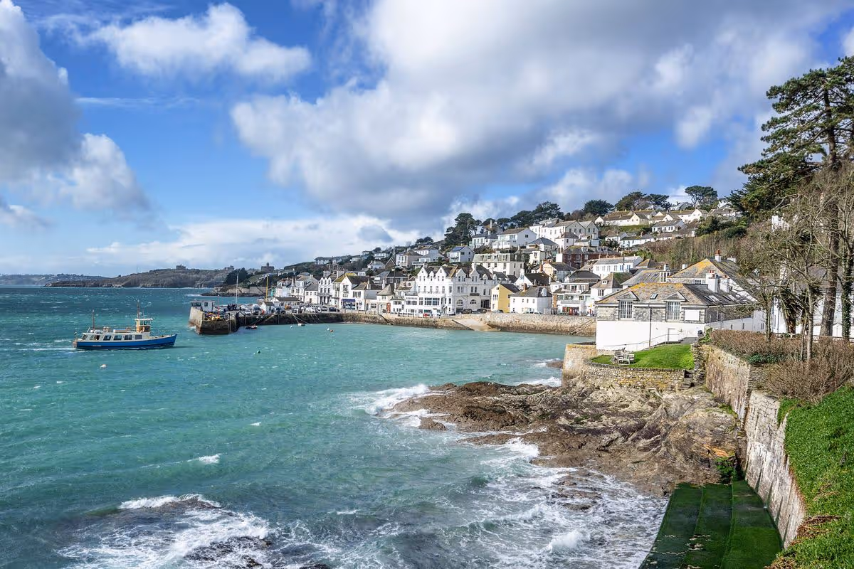
guide

What are Hols from £9.50? The ultimate guide to booking your 2026 holidays with The Sun

THE Sun’s Hols from £9.50 returns this week, giving you the chance to book a bargain break at over 300 holiday parks across the UK and Europe.

You can take part via The Sun newspaper, with our Sun Savers or by joining Sun Club.

a family is riding scooters down a street in front of a house .
The Sun’s Hols from £9.50 are back

Join the millions of readers over the past three decades who have packed their bags for our value holidays.

Here’s everything you need to know about Hols From £9.50 and how to book…

What are Hols From £9.50?

Millions of our readers have enjoyed our fabulous breaks from £9.50 and, with over 300 holiday parks across the UK and Europe to choose from you’re sure to find a break you like.

There is something for the whole family to enjoy, whether you are after a relaxing break, action and adventure or bowling and bingo.

SAVE A HOL OF A LOT

From travel tips to cash hacks… beat the squeeze on your holidays

Breaks are available for spring, summer and autumn 2026.

Remember, we offer the best value for holiday park breaks, including four midweek nights for the price of three, so always check here first – you will not find a better deal anywhere – guaranteed.*

To find out more on our great Hols from £9.50, as well as FAQs and all the holiday parks available check out thesun.co.uk/holidays.

How do I book Hols from £9.50?

There are FIVE ways to book our Holidays From £9.50:

Most read in Beach holidays

  1. Book online: Simply collect FIVE codewords printed in The Sun daily from Saturday, January 10 to Thursday, January 29. Then enter them at thesun.co.uk/holidays to unlock booking from Wednesday, January 14.
  2. Book with Sun Savers: Download the Sun Savers app or register at sunsavers.co.uk. Then go to the ‘Offers’ section of Sun Savers and click ‘Start Collecting’ on the ‘Hols From £9.50’ page. Collect FIVE Sun Savers codes from those printed at the bottom of the Sun Savers page in the newspaper from Saturday, January 10 to Thursday, January 29. Then enter or scan the codes on Sun Savers to unlock booking from Wednesday, January 14. Or if you are already a Sun Savers member, use the bonus Sun Savers code and we will send you details to book from Tuesday, January 13.
  3. Book by post: Collect FIVE of the codewords printed in The Sun each day from Saturday, January 10 to Thursday, January 29. Cut the codeword out and send it back with the booking form – found in paper on Saturday, January 10 or online at thesun.co.uk/holidays.
  4. Book with The Sun Digital Newspaper: Sign up to The Sun Digital Newspaper at thesun.co.uk/newspaper. Then download the Sun Savers app or sign up at sunsavers.co.uk, log in to Sun Savers with your Sun account details (the same email and password you use for your Digital Newspaper) and enjoy automatic access to Hols, without the need to collect Sun Savers codes daily. Booking opens on Tuesday, January 13.
  5. Book with Sun Club: Join Sun Club at thesun.co.uk/club for £1 for 3 months. Go to the Sun Club Offers hub and find the Hols from £9.50 page. You do not need to collect any codewords or Sun Savers codes. Booking opens on Tuesday, January 13.

Terms and Conditions: Price per person based on four sharing. Multiple codeword/code collect or digital subscription required. Subject to availability. *Price guarantee based on four people sharing, excluding extras/upgrades .

Date restrictions apply.– see full T&Cs here.

How to book by joining Sun Club

Becoming a member of Sun Club lets you skip token collecting completely…

Step 1: Simply head to thesun.co.uk/club and sign up to Sun Club for just £1.99 a month.

Or £12 for an annual subscription unless you cancel at least 7 days before your next billing date.

Step 2: Once you have joined, head to the Offers Hub and click ‘Book’ on the Sun Hols from £9.50 offer from Tuesday, January 13.

Step 3: You will be taken to the Sun Holidays website to choose from thousands of breaks at over 300 parks across the UK & Europe. 

Sun Club members do not need to collect any codewords or Sun Savers codes. 

Discover the very best of the UK, from the beaches of Cornwall and Devon to the highlands of Scotland and much more.

We’ve partnered with fantastic holiday parks that offer everything from British seaside charm to remote, natural beauty.

And when you get there, choose from evening entertainment, on-site pubs and restaurants, family activities and sports.

Or if you’re looking for some guaranteed sunshine, venture further to explore top European destinations including France, Spain and Italy.

a family playing on the beach with buckets and nets
There’s something for the whole family – from relaxing seaside breaks to adventure tripsCredit: Shutterstock

Source link

New L.A. restaurants to visit from 2025 101 Best Restaurants guide

The line at Holbox during the midweek lunch hour has become a cultural sensation, a queue of locals and visitors trailing past the automatic doors and around the parking lot like devotees angling for the latest iPhone series or limited-release sneakers. Believe the lauds, including ours when we named Holbox as The Times’ 2023 Restaurant of the Year. Gilberto Cetina’s command of mariscos is unmatched in Southern California – his ceviches, aguachiles and tostadas revolutionary in their freshness and jigsaw-intricate flavors. The smoked kanpachi taco alone — clinched with queso Chihuahua and finished with salsa cruda, avocado and drizzles of peanut salsa macha — is one of the most sophisticated things to eat in Los Angeles.

Holbox could be considered for the top ranking on its own strength. But in a year when disasters tore at our city, honoring the power of community feels more urgent than ever. Cetina’s seafood counter doesn’t thrive in a vacuum. Holbox resides inside the Mercado La Paloma in South L.A. The mercado is the economic-development arm of the Esperanza Community Housing Corp., a nonprofit organization founded in 1989 that counts affordable housing and equitable healthcare among its core missions. When the mercado was in the incubation stage, Esperanza’s executive director Nancy Ibrahim interviewed would-be restaurateurs about their challenges and hopes in starting a business. Among the candidates was Cetina’s father, Gilberto Sr., who proposed a stall serving his family’s regionally specific dishes from the Yucatán. Their venture, Chichén Itzá, was among the eight startups when the mercado opened in a former garment factory nearly 25 years ago, in February 2001.

Step into the 35,000-square-foot market today, and the smell of corn warms the senses. Fátima Juárez chose masa as her medium when she began working with Cetina at Holbox in 2017. Komal, the venue she opened last year with her husband, Conrado Rivera, is the only molino in L.A. grinding and nixtamalizing heirloom corn varieties daily. Among her deceptively spare menu of mostly quesadillas and tacos, start with the extraordinary quesadilla de flor de calabaza, a creased blue corn tortilla, bound by melted quesillo, arrayed with squash blossoms radiating like sunbeams.

Wander farther, past the communal sea of tiled tables between Holbox and Komal, to find jewels that first-timers or even regular visitors might overlook.

Taqueria Vista Hermosa, run by Raul Morales and his family, is the other remaining original tenant. Order an al pastor taco, or Morales’ specialty of Michoacan-style fish empapelado smothered in vegetables and wrapped in banana leaf. The lush, orange-scented cochinita pibil is the obvious choice next door at still-flourishing Chichén Itzá, but don’t overlook crackling kibi and the brunchy huevos motuleños over ham and black bean puree. The weekends-only tacos de barbacoa de chivo are our favorites at the stand called Oaxacalifornia, though we swing through any time for the piloncillo-sweetened café de olla and a scoop of smoked milk ice cream from its sibling juice and snack bar in the market’s center. Looking for the comfort of noodles? Try the pad see ew at Thai Corner Food Express in the far back.

The everyday and the exquisite; the fast and the formal (just try to score a reservation for Holbox’s twice-a-week tasting menu); a food hall and sanctuary for us all. Mercado La Paloma embodies the Los Angeles we love.

Source link

A guide to Montecito Hot Springs, where you can soak in a rustic oasis

p]:text-cms-story-body-color-text clearfix”>

The water bubbles up hot from the earth and sunlight filters down through the branches of mighty oaks.

But before you can soak in Santa Barbara County’s highly popular Montecito Hot Springs, you’ll need to hike a little over a mile uphill, threading your way among boulders, oaks and a meandering creek. And before the hike, there are two other crucial steps: getting to the trailhead and knowing what to expect.

The trail to Montecito Hot Springs surrounded by trees and brush.

The trail to Montecito Hot Springs.

These rustic spring pools are about 95 miles northwest of L.A. City Hall, just upslope from well-to-do Montecito, whose residents include Oprah Winfrey, Prince Harry and his wife, Meghan Markle, and Gwyneth Paltrow.

Though the trail and hot springs are part of Los Padres National Forest, the trailhead is in a residential neighborhood of gated mansions. Beyond the trailhead parking area (which has room for eight or nine cars), the neighborhood includes very little curbside parking. After visitation surged during the pandemic, some neighbors were accused by county officials of placing boulders to obstruct public parking. Parking options were reduced further when county officials added parking restrictions earlier this year.

  • Share via

Bottom line: Unless you can arrive on a weekday between 8 and 10 a.m., you’re probably better off taking a rideshare service to get there. Whenever you arrive, you’re likely to have company. And you might want to wait until the landscape dries out a bit from the rains of recent weeks.

As Los Padres National Forest spokesman Andrew Madsen warned, “the foothills of Santa Barbara are especially fragile and hiking is especially precarious in the aftermath of heavy rains.”

All that said, the hike is rewarding and free. From the Hot Springs Canyon trailhead at East Mountain Drive and Riven Rock Road, it’s a 2.5-mile out-and-back trail to the hot springs, with about 800 feet of altitude gain on the way.

Arriving at 10 a.m. on a Tuesday, I got the last parking spot at the trailhead, stepped past the signs forbidding parking before 8 a.m. or after sunset, then stepped past another sign warning that “this is a challenging and rugged hike.” Also, there are no bathrooms or trash cans on the trail or at the springs.

“It’s important that people know what’s going on up there before they show up,” said Madsen. “It’s not all that glamorous.”

Even though it’s only 1.2 or 1.3 miles to the hot springs, plan on about an hour of uphill hiking. Once you’re above the residential lots, you’ll see pipes along the way, carrying water down the hill, along with occasional trailside poison oak. As you near the pools, you’ll pick up the scent of sulfur and notice the water turning a strange bluish hue. Then the trail jumps across the creek — which I initially missed.

But there was a silver lining. That detour gave me a chance to admire the stone ruins of a hotel that was built next to the springs in 1870s. After a fire, it became a private club. Then it burned in the Coyote fire of 1964, which blackened more than 65,000 acres, destroyed more than 90 homes and killed a firefighter. The hot springs and surrounding land have been part of Los Padres National Forest since 2013.

Hikers look west over flowers and greenery from behind low stone ruins near Montecito Hot Springs.

Hikers look west from the ruins near Montecito Hot Springs.

(Christopher Reynolds / Los Angeles Times)

On a clear day with the sun in the right place, you can stand among the overgrown ruins, look west and see the ocean, a few old oil platforms and the long, low silhouette of Santa Cruz Island. This is what the native Chumash would have seen (minus the oil platforms) through the many years they used the springs before European immigrants arrived.

Pleasant as that view was, I was ready to soak, as were the two couples who got momentarily lost with me. (We were all Montecito Hot Springs rookies.) Once we’d retraced our steps to the creek and crossed it, the trail took us quickly past a hand-lettered CLOTHING OPTIONAL sign to a series of spring-fed pools of varying temperatures.

A dozen people were already lazing in and around the uppermost pools (one woman topless, one man bottomless), but several pools remained empty. I took one that was about 2 feet deep and perhaps 90 degrees. In one pool near me sat Ryan Binter, 30, and Kyra Rubinstein, 26, both from Wichita, Kan.

Hikers Ryan Binter and Kyra Rubinstein soak at Montecito Hot Springs.

Hikers Ryan Binter and Kyra Rubinstein, visiting from Wichita, Kan., soak at Montecito Hot Springs.

(Christopher Reynolds / Los Angeles Times)

“She found this,” said Binter, praising Rubinstein’s internet search savvy.

At the next pool were Emanuel Leon, 20, of Carpinteria, Calif., and Evelyn Torres, 19, of Santa Barbara. The last time they’d tried this hike, they’d strayed off-track and missed the hot springs, so this time, they were savoring the scene.

“Revenge!” said Leon, settling in.

The soaking was so mellow, quiet and unhurried that I was surprised to learn that the pools were not erected legally. As Madsen of the Los Padres National Forest explained later by phone, they were “created by the trail gnomes” — hikers arranging rocks themselves to adjust water flow and temperature, with no government entities involved.

Legal or not, they made a nice reward after the hike uphill. The downhill hike out was easier and quicker, of course, but still tricky because of the rocks and twisting trail.

On your way out of Montecito, especially if it’s your first time, take a good look at the adobe-style grandeur of the Our Lady of Mt. Carmel Catholic Church building, which looks like it was smuggled into California from Santa Fe. For food and drink, head to Coast Village Road (the community’s main drag) or the Montecito Village Shopping Center on East Valley Road. Those shops and restaurants may not match the wonder and comfort of a natural bath in the woods, but for civilization, they’re not bad.

Source link

Your hiking and camping guide to Angeles National Forest

Los Angeles is a place where essentially anyone can find themselves, especially outdoors lovers.

The hiking trails of Griffith Park offer tremendous views of the city and landscape. Kenneth Hahn State Recreation Area near Culver City features lush spaces to spend a Saturday with family and friends. But for Angelenos seeking adventure — and even solitude — a vast forested expanse awaits.

Angeles National Forest is a 700,000-plus acre wonderland that has long billed itself as L.A.’s “backyard playground.” But it’s so much more than that.

For almost a decade, I’ve hiked much of its 557 miles of trails, and so rarely was it just for exercise. I’ve sought refuge in our San Gabriel Mountains when life got overwhelming, whether it was after my brother died and my soul ached more than I could communicate, or it was just to briefly escape news headlines that kept breaking my heart. But it was also for joy.

Every hike in Angeles National Forest offers us a chance to be awestruck by our natural environment. I’ll never forget the first time I saw a California newt waddling through Millard Canyon falls. I’ve spotted hopping deer, hooting owls and exactly one haughty rattlesnake (as all other rattlers were much calmer — even the one my dog booped).

I’ve felt the temperature shift from cool to crisp on a winter’s day hike in Icehouse Canyon as a cold mist wafted through the trees, and I’ve sweated through my clothes on the exposed hillsides of the Strawberry Peak trail. I’ve made snow angels with my dog near Mt. Waterman and swam in my skivvies in the San Gabriel River.

Years ago, Angeles National Forest supervisor Michael J. Rogers pointed out what anyone who has spent time there knows too well.

“This is a national forest that could very easily be enjoyed and loved to death,” Rogers wrote for The Times on the forest’s 100th anniversary in 1992. “All of the unique values that visitors seek such as cool trees, shaded streams, solitude, beautiful vistas, watchable wildlife, fresh pine-scented air could all be lost through overuse and abuse.”

My intention with this guide falls in line with Rogers’ message: I hope you not only appreciate what the forest has to offer but also understand your responsibility to practice the “leave no trace” principles, leaving only footprints and taking only memories (and selfies).

Adventure awaits in Angeles National Forest. May you find the start and continuation of it in this guide.

Note: To bookmark this page for future use, press Ctrl+D (Windows/Linux) or Cmd+D (Mac).

A quick geography lesson| What to bring | Getting there | Things you should know | Beginner adventures| Intermediate adventures| Advanced adventures

A quick geography lesson

A sweeping view of Angeles Crest Highway.

A sweeping view of Angeles Crest Highway and the San Gabriel Mountains from the Hoyt Mountain trail.

(Jaclyn Cosgrove / Los Angeles Times)

Angeles National Forest is about 700,000 acres of federal land managed by the U.S. Forest Service. Its northern boundary extends through mountain ranges near the 5 Freeway near Gorman, eastward to the L.A. County and San Bernardino County line near Wrightwood. Its southern boundary runs near Castaic Lake southeast and eastward, ending north of Claremont, where the San Bernardino National Forest’s boundary begins.

It is located within a portion of the Sierra Pelona Mountains in the west, and the San Gabriel Mountains, which span about 60 miles from near Newhall to Cajon Canyon northeast of San Bernardino, according to state geology research. Angeles National Forest’s elevation ranges from 1,200 feet to 10,064 feet, its highest point being Mt. San Antonio, or Mt. Baldy as it’s more commonly known.

The original home of several Indigenous communities for thousands of years, the forest grows several species of trees, plants and animals endemic only to the San Gabriel Mountains or California, including the San Gabriel manzanita, the big cone Douglas fir and the endangered mountain yellow-legged frog. An estimated 14%, or about 29,000 acres, of Angeles National Forest is considered “old-growth” forest — white fir, lodgepole pine, Jeffrey pine (which has a bark that smells like butterscotch or vanilla), ponderosa pine and others that have grown for more than a century into hulking giants.

It is home to five wilderness areas: Cucamonga Wilderness; Magic Mountain Wilderness; Pleasant View Ridge Wilderness; San Gabriel Wilderness; and Sheep Mountain Wilderness. Wilderness areas are the “most protected” federal land in the country. Each of these wilderness areas offers something different. For example, when hiking in Cucamonga, you might spot bighorn sheep, while Magic Mountain is occasionally host to a California condor passing through.

layers of mountains covered in evergreen and pine trees

The view of the San Gabriel Mountains as seen from the Mt. Waterman area in the Angeles National Forest.

(Genaro Molina / Los Angeles Times)

What to bring

A full tank or battery. Consider entering the forest with either a full tank of gas or full charge on your vehicle’s battery. There are no gas or electric charging stations (outside of a plug-in you might find on a forest service building).

Sustenance. If hiking, you will likely want to pack all of the water you need for the day unless you plan to filter it from somewhere along the trail. If camping, check the Angeles National Forest website to see whether your campground offers drinking water. You will also want to bring all of your food, unless you plan to visit one of the few places — including Camp Williams Cafe, Cosmic Cafe, the Adams Pack Station or Top of the Notch restaurant — in the forest to buy food and you know the establishment will be open.

A thoughtfully packed bag. When preparing for a hike, some pack the “10 essentials,” which includes navigation tools, a light source and emergency shelter, while others preach a different method of considering specifically what’s needed for the day. Search and rescue team members generally recommend that folks have in their pack whatever they’d need to spend a night in the woods, just in case things go awry.

Parking pass. To park in most places in the forest, you will need a $5 single-day Adventure Pass, a $30 annual Adventure Pass or an America the Beautiful pass. You can be ticketed without properly displaying your pass. If visiting trails near Wrightwood, you might need a Big Pines parking pass, as many of those locations are managed by a concessionaire, Mountain High.

A view from a car driving up a road with snowy mountains in the distance.

Driving up Angeles Crest Highway to Mountain High.

(Ryan Fonseca / Los Angeles Times)

Getting there

Much of Angeles National Forest’s hiking trails and day-use areas through the San Gabriel Mountains can be accessed via the 66-mile, winding Angeles Crest Highway, or State Route 2. The speed limit is 55 mph, unless otherwise posted. It’s advisable to take it easy, though, both to enjoy the view and avoid an accident.

State Route 39, another winding mountain road, takes visitors north to popular trails along the San Gabriel River and into the Crystal Lake area. The road features jaw-dropping views of the San Gabriel Valley, occasional wildflower blooms and steep drop-offs. Best to let whoever in your party isn’t scared of heights drive.

tall skinny plant with purple petals

Lupine is sometimes spotted on the hillsides around San Gabriel Canyon Road (Highway 39) in the Angeles National Forest north of Azusa.

(Raul Roa/Los Angeles Times)

In 1978, a landslide destroyed the segment of Highway 39 that connected it to Highway 2, turning it into what one public official called “a 27-mile-long cul-de-sac.” Officials have said it is too costly — and dangerous to bighorn sheep — to repair, although there have been recent discussions about its reopening.

Regardless of where you’re traveling in Angeles National Forest, you should check road conditions before heading out, especially in the winter, as officials will close forest roads to protect the public, including because of snow, or require that drivers carry tire chains.

You should keep in mind while traveling to trailheads that it is considered rude in mountain driving culture not to let faster vehicles pass you. Angeles Crest Highway has several paved turnouts for this reason. Additionally, please take good care to notice signage regarding segments of the highway where daytime headlight use is required.

Lastly, be aware that there are dirt fire roads and several off-road vehicle routes through the forest. Your phone or car’s mapping app might try to send you down one to reach a trail. Please do not assume a road will be passable just because it’s open. When in doubt, call the ranger station before heading out.

Things you should know

Communicating while away. You should assume you won’t have cellphone reception anywhere in Angeles National Forest. For safety while you’re out of your mobile service area, you should share this form with a family member or friend to ensure someone knows where you’re headed. You should also print the form and place it on your dashboard so, in the event of emergency, rescuers can find you more quickly than having to track down details of your whereabouts from your family. If you forget to bring the form, simply write down the details of your day or overnight trip, including when you expect to return, and leave them on your car dash.

Emergencies. Emergency services in Angeles National Forest include 23 fire stations such as the Clear Creek Fire Station and the Monte Cristo Fire Station off Highway 2. Volunteer search-and-rescue crews respond in most hiking emergencies. If you are ever rescued by helicopter, you will not be charged by these groups. That said, they’re always in need of donations to stay afloat.

Fire restrictions. Forest officials will, at times, limit campfires and stove usage because of elevated wildfire risk. Before heading out, check the Angeles National Forest alerts webpage to discern what’s allowed on your trip. If campfires are allowed, you must still secure a free campfire permit and have a copy with you.

A clear highway with one car surrounded by snow-covered trees.

A vehicle heads north on Highway 39 into a winter wonderland with a good accumulation of snow at the 5,000-feet level in the Angeles National Forest north of Azusa in January.

(Raul Roa / Los Angeles Times)

Weather. Checking the forecast is not always top of mind for your average Angeleno, but hikers and campers must assess the weather before leaving for the forest. Temperatures in Angeles National Forest can range from below freezing overnight in winter, especially above 6,000 feet, to above 100 degrees in summer. Even after checking the forest, remember that elevation will play a role in temperature. Generally, for every 1,000 feet you gain, the temperature can drop from around 3½ to 5 degrees, something meteorologists call “environmental lapse rate.”

Eaton fire closures. Please note that the following guide does not include any of the trails burned in the Eaton fire, as they remain closed. Once they’re open, this guide will be updated.

Leave no trace. Whenever you hike, camp or otherwise visit Angeles National Forest, please practice the “leave no trace” principles, which include packing out everything you pack in, respecting the animals (which means not taking selfies with them), and overall ensuring these lands are protected for generations to come.

With that said, take a deep breath, and imagine being surrounded by the fresh scent of pine as mountain chickadees chirp all around you. Yes, friend, that’s possible — and all within a short drive of L.A. Let’s go on an adventure!

Forest scene illustration with a couple putting together a campground tent with their dog looking inside the tent flap

(Ruby Fresson / For The Times)

For Angelenos seeking a relaxing respite (easy)

It might seem daunting to drive into the hulking mountains surrounding L.A., but there are many easy-going and family-friendly adventures to be had in Angeles National Forest. Many families and friend groups spend time visiting vista lookouts and at one of several day-use picnic areas, which often feature picnic tables and grills (when allowed).

Here you’ll find some kid-friendly and wheelchair accessible trails and other opportunities, including campgrounds where you can easily drive up and spend a weekend.

Large boulders at the Mt. Hillyer summit.

Large boulders at the Mt. Hillyer summit.

(Jaclyn Cosgrove / Los Angeles Times)

Hiking trails

🌇For great views: the Mt. Wilson Observatory paved walking paths; Crystal Lake walking path.

🌳To be among tall trees: Joatngna Trail (the Elfin Forest Trail); the paved Buckhorn Campground paths.

💧For cool rivers, lakes and cascading falls: the West Fork National Scenic Bikeway (paved for the most part); San Antonio Falls trail (paved, but uphill); Gould Mesa Campground via the Gabrielino Trail (including about one mile of paved trail to start).

🪨To see massive rock formations: Mt. Hillyer via Silver Moccasin Trail (great for older kids); Mt. Hillyer Trail from Horse Flats Campground (easier, flatter option!).

Campgrounds

These campgrounds are in the “easy” category because they’re straightforward to reach. Additionally, they all usually offer piped (i.e. drinking) water, but you should check on the campground sites linked here to ensure it is available before heading out.

A hammock set up between two trees at Crystal Lake Campground.

Crystal Lake Campground is a 120-site campground north of Azusa.

(Raul Roa / Los Angeles Times)

The campgrounds below range from $12 to $30 per night for single sites ($5 per additional vehicle), with some requiring payment by cash or check. They are available on a first-come, first-served basis unless otherwise noted; feature picnic tables and fire rings; have vault toilets; and allow dogs.

  • Appletree Campground: Open year-round, Appletree features eight first-come, first-served walk-in sites that are a short distance, less than 100 yards, from the parking area. Three sites are ADA accessible. A Big Pines pass from Mt. High is required to park. Each site has a grill on top of the usual amenities. The campground is only 10 minutes from Wrightwood, a cozy mountain town with restaurants and a local grocery store.
  • Buckhorn Campground: Arguably one of the most beautiful of Angeles National Forest’s campground offerings, Buckhorn is a popular 38-site campground shaded by California incense-cedar, white fir and tall sugar and Jeffrey pine trees. It sits at around 6,500-feet elevation and, as such, is open from spring to fall since it is often blanketed in snow come winter. Campers should be prepared to pack their food and scented items in the bear boxes supplied, as our ursine neighbors are around the area. Many campers walk the short distance to the Burkhart trailhead and visit Cooper Canyon Falls, a 40-foot cascade reachable by carefully scrambling down from the trail. Others simply lounge in hammocks and play in the seasonal spring that runs through the site.
  • Chilao Campground: Chilao has 84 campsites spread over two loops, Little Pines and Manzanita. Its landscape features large boulders, sweeping views and pine trees (especially the eponymous loop). Piped water is available, although it is at times turned off, so please check the campground website before heading out. The Chilao Visitor Center, open on the weekends, is nearby.

  • Coldbrook Campground: Coldbrook Campground sits on the north fork of the San Gabriel River, where visitors can splash around its cool waters. Its 22 campsites offer shade and a river soundscape.
  • Crystal Lake Campground: Crystal Lake is a 120-site campground north of Azusa. It sits at 5,539-feet elevation and features great views of nearby peaks, including Mt. Islip and Windy Gap. Visitors can fish in Crystal Lake when it’s deep enough and find a hot meal at Crystal Lake Cafe and General Store.
  • Los Alamos Campground: One of few campgrounds in Angeles National Forest requiring reservations, the Los Alamos Campground has 90 individual and three group camp sites. Visitors are a short drive from Pyramid Lake where they can swim at Vaquero Beach or fish and boat elsewhere. Call ahead to ensure that Pyramid Lake isn’t experiencing an algal bloom, which has been a common occurrence in recent years.
  • Monte Cristo Campground: Monte Cristo has 19 individual drive-in sites, including some with large shady sycamore trees. A small creek runs through the middle of the campground and has small pools to splash in. Drive 2½ miles south to the nearby Hidden Springs Picnic Area for more swimming.
  • Table Mountain Campground: Open spring through fall, Table Mountain has more than 100 campsites that can be reserved through Recreation.gov, although first-come first-served may, at times, be available. This large campground is operated by Mountain High Resort near Wrightwood and near the company’s North Lodge, where guests can play a round at the disc golf course with sweeping views of the desert below. A Big Pines pass from Mt. High is required to park.

Bonus spots

The forest and the surrounding area have far more to explore than hiking trails and campgrounds. Some of the spots listed here are outside the forest but are included because they’re worth visiting when nearby.

Visitors walk through fields of California poppies.

Visitors walks on a path through fields of California poppies in the Antelope Valley California Poppy Reserve in Lancaster.

(Francine Orr / Los Angeles Times)

  • The Antelope Valley California Poppy Reserve: Although not in Angeles National Forest, this state natural reserve is over 1,700 acres of open space that bursts, when conditions are right, with bright orange poppies from sometime between mid-February to May. Note: Do not leave the trail and trample the poppies to nab selfies or other images, regardless of whether you see others doing it.

    A small olive-gray songbird with white and black wing bars, gently held by a human in their hand

    A ruby-crowned kinglet after it was measured and banded at the Bear Divide banding station near Santa Clarita.

    (Jaclyn Cosgrove / Los Angeles Times)

  • Bear Divide Banding Station: Volunteers operate this banding station seasonally from late March through mid-May. They place nets on the hillside to catch migratory birds that they add small metal bands to the legs of, collecting annual population data for further research.
  • Camp Williams: A privately operated RV and tent campground on the East Fork of the San Gabriel River; also has a cafe that’s open on weekends.
  • Cali Splash Park at Castaic Lake: If hiking near Castaic Lake, the Cali Splash Park offers what’s essentially a massive bounce house and obstacle course in the middle of a lake, a memorable experience and fun surprise after an early morning hike.

    Jackson Lake in Angeles National Forest near Wrightwood.

    Jackson Lake in Angeles National Forest near Wrightwood.

    (Jaclyn Cosgrove / Los Angeles Times)

  • Elizabeth Lake Day Use: A small picnic area about 30 minutes west of Lancaster where visitors can fish and kayak on a seasonal lake, or sag pond, formed by the San Andreas fault.
  • Jackson Lake: A small mountain lake near Wrightwood where Mountain High, a local ski resort, offers kayak, paddleboard and pedal boat rentals until the winter season. Guests can also fish, as the lake is stocked with rainbow trout several times a year, according to Mountain High.
  • Mt. Wilson Observatory: Visitors can look through large telescopes, enjoy Sunday afternoon concerts, take guided tours of the grounds and snag a bite to eat at the Cosmic Cafe, which is open seasonally.
  • Placerita Canyon Nature Center: Although not in Angeles National Forest, this charming facility near Santa Clarita is within a short hike from federal land. Swing by before a hike, and you can say hello to the animal ambassadors, which usually include red-tailed hawks and other native birds.
  • Stonyvale Picnic Site: A lesser-traveled picnic area with 11 tables and grills near Big Tujunga Creek, where families and friends can spend the day splashing in its cool waters, especially in the spring when it is flowing.
  • Vasquez Rocks Nature Center: This L.A. County park has been the site of several movies and television shows and is a fun side quest for those hiking on nearby federal forest trails.
  • Wildwood Picnic Area: A large picnic area near Sunland-Tujunga situated next to Big Tujunga Creek meanders where visitors can splash around the exposed rock bed of Stone Canyon.
Waterfall forest scene illustration with a couple looking on as their dog plays on a nearby rock

(Ruby Fresson / For The Times)

Are you ready to expand your hiking excursions beyond your favorite L.A. trails? Have you been hiking up to Mt. Hollywood, wondering what those peaks are beyond the city? Well, buckle up, buttercup, because here you’ll find an assortment of day hikes and weekend camping ideas that will have you filing for vacation before you realize you’re typing an email to your boss.

These trails are varying levels of difficulty, but are listed as moderate because none of them should require you to have significant technical outdoors knowledge. Enjoy!

Hiking trails

Hikers on the trail to Switzer Falls.

Hikers on the trail to Switzer Falls.

(Brian van der Brug / Los Angeles Times)

🌇For great views: Josephine Peak, Stoddard Peak, Tee Pee Trail, Three Points to Sulfur Springs via Pacific Crest Trail, Throop Peak, Vetter Mountain, Warm Springs Mountain.
🌳To be among tall trees: Boy Scout Trail Loop, Mt. Baldy Notch via Manker Flat, Mt. Waterman Loop, Rim Trail to Newcomb Pass, Valley Forge Trail Camp via Gabrielino National Recreation Trail, Winter Creek to Hoegees Trail Camp loop.
💧For cool rivers and cascading falls: Bridge to Nowhere, Brown Mountain Dam Waterfall, Cooper Canyon Falls via the Burkhart Trail, Fish Canyon Narrows, Sturtevant Falls Trail, Switzer Falls trail, Trail Canyon Falls.
🪨To see massive rock formations: Castaic Rock Trail near Castaic Lake, Devil’s Chair Trail, Mt. Hillyer via the Silver Moccasin Trail.

Campgrounds

These campgrounds are considered “moderate” because they either do not offer water but still offer car camping or they require a short backpacking trip. They offer opportunity for memorable outdoor experiences in remote places without making you feel like you’re secretly being filmed for “Naked and Afraid.”

The campgrounds here range from free to $12 per night ($5 per additional vehicle); available on a first-come, first-served basis; feature picnic tables and fire rings; have vault toilets; and allow dogs.

  • Cooper Canyon Trail Camp: The Cooper Canyon Trail Camp is a backcountry campground shaded by towering old pine trees. It has five sites, and bear-proof boxes are available to store food and scented items. It can be reached a few different ways, including a 1½-mile one-way trip down a fire road starting at Cloudburst Summit. There is no piped water. Campers will need to either bring their own or filter water from the nearby river.
  • Gould Mesa Trail Camp: Gould Mesa is a five-site backpacking campground accessed by a two-mile hike via the Gabrielino Trail starting near Pasadena. It can also be accessed by hiking Gould Mesa Road from La Cañada Flintridge. The Arroyo Seco flows nearby and offers seasonal swimming holes for campers. No fee charged outside of Adventure Pass for your vehicle at the trailhead.
  • Glenn Camp Campground: Accessible via a seven-mile bike ride or hike, the Glenn Camp Campground is a 10-site forested haven next to the West Fork of the San Gabriel River. There is no piped water. Campers will need to either bring their own or filter water from the nearby river.
  • Horse Flat Campground: Horse Flat is a 26-site shaded campground offering corrals and hitching posts should you have an equine companion. It is close to the Silver Moccasin National Recreation Trail, which you can hike to nearby Mt. Hillyer for bouldering. No water available. Closes seasonally.
  • Oak Flat Campground: Oak Flat is a rustic 20-site campground near Castaic that will provide you with an easy night of car camping although you might, at times, hear Interstate 5. Shaded by oak trees, the campground is close to Whitaker Peak and Piru Creek at Frenchman’s Flat. There is no piped water, so campers will need to bring their own.

Bonus spots

A deep blue lake with mountains nearby.

Pyramid Lake near Castaic.

(Eric Thayer / Los Angeles Times)

  • Adams Pack Station: A last remaining pack station in Southern California, this rustic shop in Big Santa Anita Canyon sells hot meals, hiking gear and souvenirs. Its wooden deck is close to the donkeys, who are worth saying hello to.
  • Castaic Lake: A fishing and swimming spot to cool off after a hike in the western Angeles National Forest.
    Two donkeys peer out of a stall.

    Cora and Kenny, two donkeys at Adams Pack Station in Big Santa Anita Canyon.

    (Jaclyn Cosgrove / Los Angeles Times)

  • Chantry Flat picnic area: A large picnic area with grills offering a great spot to rest after a nice hike through nearby Big Santa Anita Canyon.
  • Devil’s Punchbowl Natural Area and Nature Center: An L.A. County park near Pearblossom with massive rock formations and easy access to Angeles National Forest trails nearby.
  • Green Valley SmokeHouse: Nestled in the gorgeous rural town of Green Valley, this is a family-owned local restaurant with a robust menu that features both meat by the pound and vegan options. It’s an easy stop if you’re hiking or camping in the western end of Angeles National Forest.
  • Sturtevant Camp: Founded in 1893, the camp has cabins to rent, but is also a fun day trip. It’s a four(ish)-mile hike from Chantry Flat to reach the camp. If you would prefer not to haul in your gear, you can hire a mule team from Adams Pack Station to carry it for you.
Forest scene illustration with of a dog looking at colorful fall leaves

(Ruby Fresson / For The Times)

For the adventurer whose friends regularly call them ‘hardcore’ at parties (advanced)

The trails here are challenging but worthy adventures for experienced hikers to consider. What does “experienced” mean exactly? Unlike the trails categorized above as “easy” or “moderate,” the trails here require you to plan ahead, bringing plenty of water and other supplies, looking over topography maps and reading trail reports. With proper planning, though, you will find yourself on a great adventure that’s also close to home. Please note: Some of the trails below may be covered in snow in winter and require technical experience.

🌇For great views: Crystal Lake to Mt. Islip; Crystal Lake to South Mt. Hawkins; Fox Mountain via the Condor Peak Trail; Hoyt Mountain via Grizzly Flat; Jupiter Mountain Loop; Liebre Mountain via PCT; Magic Mountain; Mt. Baldy via Devil’s Backbone Trail; Mt. Lukens via Haines Canyon; Slide Mountain; the Three T’s via Icehouse Canyon; Townsend Peak; Whitaker Peak.
🌳To be among tall trees: Mt. Waterman to Twin Peaks; Mt. Baden Powell; Ontario Peak; Cucamonga Peak (with permit); Mt. Hawkins; Pacifico Mountain.
💧For cool rivers and cascading falls: Icehouse Canyon to Icehouse Saddle Trail, Oak Springs Trail
🪨To see massive rock formations: Strawberry Peak; Islip Saddle to Mt. Williamson Ridge.

Backpacking opportunities near L.A.

  • The Gabrielino Trail is a 26(ish)-mile National Recreation Trail that hikers traditionally start at Chantry Flats and hike north, west and finally south to its exit point near Pasadena.
  • The entire Silver Moccasin Trail, another National Recreation Trail in Angeles National Forest, is 53 miles — and you could buy yourself a vintage Scouting America “Silver Moccasins” badge on eBay afterward as a humble brag to friends.
  • An estimated 176 miles of the Pacific Crest Trail‘s 2,500 miles are through Angeles National Forest. Per the forest service, you can take the trail through Angeles high country, from near Mt. Gleason through Mill Creek Summit, Mt. Pacifico, Sulphur Springs, Cooper Canyon, Mt. Williamson, Little Jimmy, Mt. Baden-Powell and Blue Ridge and on to the Cajon Pass area.

Campgrounds

The campgrounds here are considered “advanced” because they require a level of planning and preparation that falls beyond your average car-camping trip. Several are backpacking sites and do not offer potable water. Some do not have streams to filter water. Despite the challenge to reach them, they are worth it for the sweeping views and solitude, the ability to nap under a hulking pine tree without interruption, outside of maybe a Steller’s jay curious about whether the weird animal (i.e. you) in its yard has any food to steal.

Unless otherwise noted, the campgrounds here range from free to $12 per night ($5 per additional vehicle); are available on a first-come, first-served basis; and allow dogs.

  • Big Rock Campground: Big Rock has eight free first-come, first-served sites, with picnic tables and campfire rings. It has vault toilets. Big Rock is on the “expert” list because the road to reach it is frequently closed. This means you’ll need to hike about one-eighth of a mile from a locked gate or take a 4×4 high-clearance vehicle from Vincent Gulch down Big Rock Creek Road (if open). You could also park at Vincent Gulch (displaying a Big Pines parking pass) and hike down the road to reach the campground. Either way, you’ll likely find solitude and hopefully seasonal springs to filter water from. Otherwise, you’ll need to pack in what you need.
  • Bear Camp: This trail camp, labeled “extremely primitive” by the Forest Service, has seven sites, each with a picnic table and campfire ring. It does not have toilets. Bear Camp is located on the far northwestern corner of the forest and is best reached by 4×4 or mountain bike, or by hiking the Pacific Crest Trail, which passes by it. It is, per the Forest Service, “extremely primitive” and lacks toilets or water. That said, each site features fire rings, bear-proof storage lockers and picnic tables.
  • Hoegees Trail Camp: A 14-site backcountry trail camp accessed by hiking by a 2½-mile, one-way hike up the Upper Winter Creek Trail in Big Santa Anita Canyon.
  • Little Jimmy Trail Camp: Little Jimmy is a 16-site campground positioned among tall trees at 7,500-feet elevation. It has a seasonal spring where campers can filter water when the spring is running. It is free. It has vault toilets. Each site has bear boxes, as it is an area of high bear activity, along with picnic tables and campfire rings. You can reach it via a 1½-mile hike from Islip Saddle.
  • Messenger Flats Campground: A backcountry campground reachable via a 10-mile hike from Mill Creek with vault toilets and picnic tables. Potable water is not available.
  • Mt. Pacifico Campground: A 10-tent-only campground with picnic tables and vault toilets but no potable water. Mt. Pacifico is reachable by high-clearance vehicles until the first winter storm of the season is expected, and the Forest Service then closes the road. Hikers can access the campground all season by taking the road or Pacific Crest Trail before turning east onto a spur that leads to the campground.
  • Sawmill Campground: Although you can drive to the eight-site Sawmill Campground, it is on the “hard” list because of the drive itself over a bumpy, steep, dirt road. Once there, you’ll be treated to expansive views of the Antelope Valley and beyond. Each site has a picnic table and campfire ring, and there is a vault toilet available. Potable water is not available.
  • Southfork Campground: A remote and rustic 21-site campground reachable with a high-clearance vehicle, as the road isn’t maintained. Campers often visit the South Fork of Big Rock Creek to splash around and observe fish swimming about.
  • Sulphur Springs Trail Camp: Sulphur Springs Trail Camp sits at 5,300 feet and features about six tent-camping sites. You can reach it by parking at Three Points and hiking about 3.6 miles of the Pacific Crest Trail to reach the camp. Its campsites are shaded by tall pine trees, ideal for hanging a hammock. It has vault toilets but no potable water or bear boxes.
  • Spruce Grove Trail Camp: A remote seven-site trail camp accessed by a 4(ish)-mile, one-way trip from Chantry Flat Picnic Area.

Bonus spots

The Mt. Baldy Lodge offers cabins.

The landmark Mt. Baldy Lodge, with quaint and cozy cabins in the village just as you enter town.

(Chris Erskine / Los Angeles Times)

  • Buckhorn Ski Lodge: A backcountry ski club with an off-grid cabin in a remote area of Angeles National Forest.
  • Mt. Baldy village: A small community near several popular trailheads where you can stop to eat at the Mt. Baldy Lodge and visit the Mt. Baldy visitor center, which is open generally midday on weekends. You can check the forest’s website for the visitor center’s latest hours.
  • Rowher Flats OHV: An off-roading site for motorcycles, ATVs and 4-wheel drive vehicles. Get your vroom-vroom on via several miles of trails.
A brown sign that reads "May your search through nature lead you to yourself."

A contemplative sign in Big Santa Anita Canyon in Angeles National Forest.

(Jaclyn Cosgrove / Los Angeles Times)

Respecting the land 🗻

L.A. is the second largest city in the U.S. and is often called the “entertainment capital of the world.”

But it offers residents and visitors alike the rare opportunity to spend the morning along bustling Hollywood Boulevard before finding total solitude in Angeles National Forest. With that opportunity comes a great responsibility to protect it so that Angeles National Forest is not loved to death but rather cherished for generations to come.


Source link

Most affordable restaurants from 2025 101 Best Restaurants guide

The line at Holbox during the midweek lunch hour has become a cultural sensation, a queue of locals and visitors trailing past the automatic doors and around the parking lot like devotees angling for the latest iPhone series or limited-release sneakers. Believe the lauds, including ours when we named Holbox as The Times’ 2023 Restaurant of the Year. Gilberto Cetina’s command of mariscos is unmatched in Southern California – his ceviches, aguachiles and tostadas revolutionary in their freshness and jigsaw-intricate flavors. The smoked kanpachi taco alone — clinched with queso Chihuahua and finished with salsa cruda, avocado and drizzles of peanut salsa macha — is one of the most sophisticated things to eat in Los Angeles.

Holbox could be considered for the top ranking on its own strength. But in a year when disasters tore at our city, honoring the power of community feels more urgent than ever. Cetina’s seafood counter doesn’t thrive in a vacuum. Holbox resides inside the Mercado La Paloma in South L.A. The mercado is the economic-development arm of the Esperanza Community Housing Corp., a nonprofit organization founded in 1989 that counts affordable housing and equitable healthcare among its core missions. When the mercado was in the incubation stage, Esperanza’s executive director Nancy Ibrahim interviewed would-be restaurateurs about their challenges and hopes in starting a business. Among the candidates was Cetina’s father, Gilberto Sr., who proposed a stall serving his family’s regionally specific dishes from the Yucatán. Their venture, Chichén Itzá, was among the eight startups when the mercado opened in a former garment factory nearly 25 years ago, in February 2001.

Step into the 35,000-square-foot market today, and the smell of corn warms the senses. Fátima Juárez chose masa as her medium when she began working with Cetina at Holbox in 2017. Komal, the venue she opened last year with her husband, Conrado Rivera, is the only molino in L.A. grinding and nixtamalizing heirloom corn varieties daily. Among her deceptively spare menu of mostly quesadillas and tacos, start with the extraordinary quesadilla de flor de calabaza, a creased blue corn tortilla, bound by melted quesillo, arrayed with squash blossoms radiating like sunbeams.

Wander farther, past the communal sea of tiled tables between Holbox and Komal, to find jewels that first-timers or even regular visitors might overlook.

Taqueria Vista Hermosa, run by Raul Morales and his family, is the other remaining original tenant. Order an al pastor taco, or Morales’ specialty of Michoacan-style fish empapelado smothered in vegetables and wrapped in banana leaf. The lush, orange-scented cochinita pibil is the obvious choice next door at still-flourishing Chichén Itzá, but don’t overlook crackling kibi and the brunchy huevos motuleños over ham and black bean puree. The weekends-only tacos de barbacoa de chivo are our favorites at the stand called Oaxacalifornia, though we swing through any time for the piloncillo-sweetened café de olla and a scoop of smoked milk ice cream from its sibling juice and snack bar in the market’s center. Looking for the comfort of noodles? Try the pad see ew at Thai Corner Food Express in the far back.

The everyday and the exquisite; the fast and the formal (just try to score a reservation for Holbox’s twice-a-week tasting menu); a food hall and sanctuary for us all. Mercado La Paloma embodies the Los Angeles we love.

Source link

A Ukraine reporter’s guide to managing wartime blackouts caused by Russia | Russia-Ukraine war News

Kyiv, Ukraine – Have you been on a plane during severe turbulence, fearing that the shaking aircraft is about to fall apart and tumble down? Brief moments of weightlessness stop your breath, perhaps you whisper prayers and remember everyone you love.

That’s the feeling you get during a Russian air raid in Kyiv, Ukraine, and there have been more than 1,800 of them since Russia’s full-scale invasion began in 2022.

Recommended Stories

list of 4 itemsend of list

These days, they are bigger, scarier and longer than ever, because each one involves hundreds of drones and dozens of missiles.

They begin after dark and sometimes last in waves until dawn. Whooshing missiles tear up the night sky in two. Drones buzz like horror movie chainsaws or giant mosquitoes out of childhood flu nightmares.

What’s really harrowing is to hear two or three drones at once – I sardonically call it “stereo” and “Dolby surround” – while the arrhythmia of bass drum-like air defence explosions coincides with your heartbeat.

Each boom and thud chokes your body with adrenaline, and some shake your house, but after a couple of hours, your brain gives up, and you fall asleep processing the booms into nightmares.

And in the morning, you fall awake – feeling hungover and disoriented – and read about the consequences. You’re glad when no one is killed, and still sad because several people are usually wounded, and several apartment buildings are damaged.

People walk near a petrol-run generator used to generate electricity for medical clinic during a power blackout after critical civil infrastructure was hit by a Russian missile and drone attacks, amid Russia's attack on Ukraine, in Kyiv, Ukraine October 10, 2025. REUTERS/Gleb Garanich
People walk near a petrol-run generator, used to generate electricity for a medical clinic during a power blackout, after critical civil infrastructure was hit by Russian missile and drone attacks in Kyiv, Ukraine, October 10, 2025 [Gleb Garanich/Reuters]

Sometimes, I think about the people who operate the drones and launch the missiles. How they come back to their families after the night shift, what they tell their children and, most importantly, themselves.

But I prefer the memory of a crowd of high school graduates who walked past my house in June, at dawn, after their prom night that coincided with an especially long and loud air raid.

Their laughter and happiness about the sunrise, the clouds of blossoming trees around them, the rugs of flowers and grass under their feet, and the future ahead of them made them sound immortal. It was a sound that defied Russian President Vladimir Putin.

In recent months, blackouts have been the most inevitable part of each air raid. It feels as though keeping millions awake and horrified during the raids is only part of Moscow’s strategy of terrorising Ukraine.

Moscow’s logic appears simple: if you do not want to surrender, you will freeze. It methodically destroys power stations, transmission and central heating lines to keep millions without electricity, light and heat.

And then there are “planned outages”. There are usually three a day, lasting between two and eight hours.

You can hear an outage because even the sounds in your ears barely register, such as the fridge’s purring or the flow of hot water in the heating system, are gone. You can see an outage because the neighbourhood lights go out, making the stars in the night sky closer and brighter.

How to survive darkness

What saves you from darkness and disconnection is gadgets.

Apart from smartphones with energy-saving modes, wi-fi hotspots and flashlights, there are laptops, tablets, wireless speakers and vacuum cleaners running on batteries.

There are also inexpensive rechargeable lamps – I have 10 of them. Three are pint-sized and bright enough for my mother to read. Three more are motion-activated, which means she can safely use the bathroom any time, and the cat is perpetually amazed.

There is a cap lamp that makes me look like a miner and helps me cook or find something in the basement, and two tiny lamps that can be stuck into a power bank and just glow in a corner.

And there is a Christmas garland in the kitchen that makes each outage feel festive.

But the most important device, the symbolic hearth of my powerless house, is a $1,200, 20kg (40lbs) battery that can keep us warm and energised for up to 12 hours.

I live on the outskirts of Kyiv in a remodelled summer house that has its own pump and a natural gas-powered heating system. Both need electricity, along with the two 50-litre (13-gallon) water heaters.

But boiling water and microwaving meals is too energy-consuming, so we stick to frying pans and an old-fashioned whistling kettle that scares the cat.

And when the power is back on, there is no room for procrastination.

You need to recharge all the lamps and devices, start a washing machine, wash dishes, and go out for groceries without risking your life while crossing the road with the traffic lights off.

The electricity’s comeback may be deceptive – sometimes, it’s too weak. I recently tried to microwave a bowl of soup, twice, but it remained cold.

And for extreme emergencies, I have a gasoline-fuelled generator.  It’s loud, shaky and stinky, and you need an entire canister of gas worth $30 for it to keep it going all night.

But such generators keep Ukraine running.

You can see them next to shops, offices and apartment buildings. Some are chained to trees or walls to prevent theft, and some are too huge and heavy to be carried away.

During a recent music festival celebrating Ukrainian composers, a giant diesel generator powered the concert hall.

My internet provider turns them on seconds after an outage begins, so I am online no matter what.

You also need to be prepared when you go out.

After covering the 2008 Russian war in Georgia, I used to drive everyone around me mad with my I-have-to-be-ready-for-any-emergency obsession.

Now, all of Ukraine feels the same obsession.

The phone has to be fully charged. There has to be a power bank in my backpack – along with a basic first aid kit, a lighter (I don’t smoke), extra batteries for the Dictaphone, pens and a pencil to take notes in subzero temperatures, when ballpen ink freezes.

A couple of months ago, I used the lighter at Kyiv’s Independence Square, dotted with hundreds of tiny Ukrainian flags next to photos of fallen soldiers.

I helped a man with a toddler light a tiny candle that he wanted to place next to the photo of his younger brother.

“He’s the toddler’s father,” the man said, and all I could utter was “God rest his soul” as I walked away, hiding tears and putting the lighter back.

Source link

A Beginner’s Guide to Analyzing Venezuela

Editor’s note: We are at a historical moment in which much of the mainstream discussion about Venezuela centers on two extremes: countering MAGA narratives, often riddled with lies and half-truths, and warning about the dangers of military intervention; or, conversely, leaning into the idea that the US will not back down from Maduro & Co., and that military intervention is imminent. Writing in absolutes and taking the words of figures like Diosdado Cabello, Stephen Miller, or even María Corina Machado at face value—within a context where they are in constant dialogue with allies and supporters—can seriously mislead audiences. Especially when framed as professional analysis. Which is not the same as opinion (as a former lady editor of this prestigious blog used to say: opinions are like assholes, everybody has one). And that’s fine. We have nothing against opinion, these pages are riddled with it.

But, again, professional analysis is something different, which is why the writing in our Political Risk Report doesn’t look at all like what we post on the webpage. Some actors posing as serious analysts and rational players are, of course, capable of generating strong headlines and plenty of material for meaty feature stories. But now, more than ever, focus should be on avoiding simplistic narratives and to bridge political discourse with on-the-ground realities, voices, and data obscured by chavismo’s censorship regime. Intelligence analyst Daniel Blanco here offers advice on how to help you identify (and/or write) credible analysis.

1) Don’t play into politics, stick to facts

Your role as an analyst, whether you are a political consultant advising a senior leader or an economic analyst with corporate clients, is to provide informed judgments to your consumers to support decision-making. It does not matter if the assumptions presented are an ugly truth; they need to be as accurate as possible. Shaping ugly truths into pleasing narratives to score points with political factions or escalate positions as a pleasing analyst can lead to policy failures or operational setbacks. Furthermore, such behaviour may end up damaging trust between analysts and consumers, as well as weakening the public credibility of your persona.  

2) Use estimative language to communicate nuance

Estimative language—using terms like likely, probable, possible, or unlikely—signals that your conclusions are based on judgments under uncertainty and prevents giving the false impression that you have absolute certainty. Consumers often come from non-technical backgrounds and may interpret analytical conclusions as statements of guarantees. Communicating the likelihood and percentages of different outcomes allows your consumers (including readers from the public in some cases) to understand that you are not presenting a black-and-white fact.

3) Keep up with the domestic context 

Context refers to the broad framework within which a foreign decision-maker operates, or within which an event or process unfolds. It is both temporal and spatial in nature. Venezuela, in particular, has a context dynamic that shifts constantly, variables that could act as an indicator yesterday could be a nothingburger tomorrow. Keeping up with the context can be the difference between interpreting data as a critical bullet point or an outdated pattern. Take for example, the power outages or connectivity blackouts that some junior analysts assessed as a major alert, while in reality, it is a common occurrence in Venezuela over the last seven years. 

4) Never assume actors are rational or cohesive 

Venezuelan actors are not always rational, and this includes decision makers in the government and the opposition. Some may act based on emotion or ideology, while others could throw personal ambition into their calculations. Assuming rationality may cause analysts to overlook actions that appear illogical but are nonetheless likely or meaningful within the actor’s perspective. Second, any organisation of human beings will produce factions. Before you assess the statement of a single actor as the current intent of a whole side, you need to take into account whether it represents a faction’s interest or if it’s part of a wider trend. 

5) Human contacts will always beat open source

Don’t get me wrong on this one, publicly available information can help you collect observable patterns or supporting evidence, but will only get you so far once you get knee-deep in assessing intentions. Venezuela runs heavily on informal power structures that are not visible on social media or tracking applications. Additionally, the civilian population, from community leaders to corporate figures, do not express their opinions or knowledge in public space due to the increasing internal repression. Developing ground contacts in different organisations is critical to collect and process information that will never be open to the public. 

6) Never stop challenging your local sources 

Speaking from experience, sources can have motives that shape their reporting. They may exaggerate their access level or withhold critical information for a variety of reasons that can range from pursuing personal agendas to avoiding political conflicts. Your responsibility to the consumer is to ensure that firsthand observation is distinguished from hearsay or speculation. Also, you need to clarify the collection method. Ask your source if they heard this in a meeting or if it is indirect information coming from a family member or a party friend. This needs to be presented in the most honest way possible in the body of your analysis.

7) Write disclaimers/statements on your analysis

Writing a statement of analysis forces the analyst to evaluate the quality of sources and identify analytical uncertainties. Often, we have to make calls on incomplete information, and the whole purpose of a statement on analysis is to let the report consumer know that there are some potholes along the road and things may turn out differently. Communicating your own level of confidence (low-medium-high) on a written report may be the difference between your decision maker acting with caution, knowing that we don’t have as much information as we like, or committing to a decision that will become a failure down the road.

Source link